

Dundas Street (Toronto)
Encyclopedia
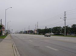
Dundas Street, also known as Highway 5
west of Toronto
, is a major arterial road connecting the centre of that city with its western suburbs
and southwestern Ontario
beyond. Originally intended as a military route to connect the capital
to the western end of Lake Ontario
at Dundas Valley
, the street today connects Toronto landmarks such as Yonge-Dundas Square and the city's principal Chinatown to rural villlages and the regional centre of London, Ontario
.
Dundas Street is also one of the few east–west routes to run uninterrupted through the Greater Toronto Area, from Toronto
to Halton Region
(the others are Eglinton Avenue
, Steeles Avenue
, Highway 7
, Castlemore Road/Rutherford Road/Carrville Road/16th Avenue, The Queensway, Bloor Street
, and Lake Shore Boulevard). Within Toronto, the TTC's 505 Dundas streetcar route
serves the street from Riverdale
to the Junction
.
shore in central Toronto, Dundas Street East originates near the Beaches
neighbourhood at Kingston Road
, itself a historic route to eastern Lake Ontario and the town of Kingston
.
Crossing the lower reaches of the Don River west of Broadview Avenue, Dundas serves as one of the few arterial roads connecting the central city
to the city's original eastern suburbs
. At Yonge Street
, Dundas intersects the city's unofficial heart at Yonge-Dundas Square, within sight of downtown landmarks such as the Eaton Centre and Ryerson University
. Called Dundas Street West from this point westward, the route passes Canada's financial heart
to the south on Bay Street
. At McCaul Street, the road fronts the Art Gallery of Ontario
in proximity to some of the city's institutions of higher learning, including OCAD University, Michener Institute, and the University of Toronto
. At Spadina Avenue
, Dundas serves as the east–west axis of the city's largest Chinatown. West of Ossington Avenue
, it meanders northwards towards Bloor Street
near the intersection of Roncesvalles Avenue
, heading north toward the Junction
district at Keele Street
. Proceeding due west from Keele through the Junction, Dundas parallels the CP Rail line through the mixed industrial-residential district. At Scarlett Road the route veers southwest toward a high crossing over the Humber River valley
, through the former village of Lambton Mills
. Beyond the river Dundas serves as the northern boundary of the upscale Kingsway
residential district. Passing the historic St. George's Church-on-the-Hill, Dundas again heads southwest toward the former village of Islington. This route traverses the west end of the city, avoiding obstacles that were expensive to negotiate in the 18th century, such as Grenadier Pond in what is now High Park
and the highest point of the Humber Valley (Bloor Street to the south requires a high bridge to cross the river at that point).
 West of the second intersection with Bloor Street in Islington, Dundas forms the route of the former Highway 5
. Upon crossing the Toronto-Peel boundary at Etobicoke Creek
, the street follows a true southwestern heading, again paralleling the lakeshore. The road passes through Mississauga, Oakville
, and Burlington
, entering rural Brant County near St. George, and ending in Paris
, with the junction of the former Highway 2
that proceeds west through Woodstock
en route to the city of London
.
In London, the street ends just east of the forks of the Thames River
before it crosses the Kensington Bridge to west London. Originally, this section was called "Dundas Street West" with the eastern portion being "Dundas Street East". However, since construction in the mid-1980s, the entire western portion has been called "Riverside Drive". Some Londoners still refer to "Dundas Street East" though no part of the street retains that name.
 Immigrant communities have sprung up along the route of Dundas Street within Toronto, with most still retaining elements of their original character. Kensington Market
was home to Toronto's first Jewish community; Spadina's Chinatown
is still the city's largest downtown Asian ethnic enclave; Brockton Village
became a west-end destination for the immigrant Irish community in the mid-19th century. This district was later settled by emigrants from Portugal and Brazil, and bears the name "Rua Açores". The Junction
attracted many immigrant labourers from Ireland
, Britain
, and Southern and Eastern Europe due to its proximity to railways and heavy industry, such as meat packing, which sprouted up there in the late 19th century.
Downtown centre
Dundas Street is centrally located in downtown Toronto, about midway between Front Street
and Bloor Street
. It serves as a major east–west thoroughfare for vehicular, transit, bicycle, and pedestrian traffic downtown and beyond. Since the building of the Eaton Centre and the Yonge-Dundas Square, the intersection of Yonge and Dundas Streets has become one of the busiest intersections in the city. It is estimated that over 56 million people pass this intersection each year. To ease traffic, a pedestrian scramble
has been installed.
Northeast of Yonge and Dundas is the Ryerson University
campus. To the east of downtown, Dundas travels through the older Cabbagetown
neighbourhood, and the large Regent Park
public housing project fills the block south of Dundas between Parliament Street and River Street.
 Art Gallery district
Dundas Street is the address of the Art Gallery of Ontario
, which takes a full city block on the south side of the street, at the corner of McCaul Street, just west of University Avenue
. The street is also home to many other art galleries, including Bau Xi Gallery
, Art Square and Show & Tell Gallery. Just to the south of Dundas on McCaul is OCAD University.
 Dundas Street was developed in different time periods and in different sections. Dundas Street is named after its one-time destination, the town of Dundas.
The section of the street near Dundas Valley was surveyed by Augustus Jones
and constructed by the Queen's Rangers
as a colonial road at the direction of John Graves Simcoe
, first lieutenant-governor of Upper Canada
. It connected the town of Dundas
to settlements west, and also around Lake Ontario
to Niagara-on-the-Lake
(Newark). The town itself was named for Henry Dundas
, Viscount Melville, British Secretary of State for the Home Department from 1791 to 1801. In the early 19th century, when Toronto's oldest streets were first named, Dundas was an important settlement in its own right, rather than simply a suburb of Hamilton
, as it has since become.
The road from the western end of Lake Ontario was constructed east to York in 1796. The road ended at the Humber River at Old Mill Road, following the path of today's Bloor Street within Etobicoke. An 1800 map shows Dundas connecting with the newly built Yonge Street, although the map does not show the route of this section within Toronto with any detail. An 1816 map of York shows a "Burlington Road", which was a westward extension of today's Queen Street.
 The first section of the current route of Dundas Street constructed in Toronto was constructed during the War of 1812. It connected today's intersection of Queen Street and Ossington Avenue to Lambton Mills
. It was constructed by the militia under the supervision of George Taylor Denison. The section of today's Ossington Avenue from Queen Street north to the intersection of Dundas Street was also known as Dundas. At the time, the district along Dundas was not cleared. Montgomery's Inn
was built on Dundas Street in 1830 for travellers along this route and also became a centre of neighbourhood business. It stands today, operated as a museum by the City of Toronto.
From Ossington Avenue to the east, Dundas was pieced together from various streets. In the latter half of the 19th century, Arthur Street was connected from Ossington Avenue and Dundas Street to Bathurst Street along the current alignment of Dundas. St. Patrick Street, the portion of today's Dundas from Bathurst Street to College Avenue (now University Avenue) bisected the Grange estate in 1877. The section from College Avenue (now University Avenue) to Yonge Street was known as Agnes Street. East of Yonge, Wilton Street, with a portion called Wilton Crescent (George Street to Sherbourne Avenue), connected to River Street. A bridge was not built over the Don River until the 20th century. The various streets were connected by jogs in the 20th century to form the current road.
In the 20th century, for purposes of efficiency, Highway 5 was redirected just west of the former village of Waterdown, Ontario
, and no longer passes through the town of Dundas, which was also located on the lower side of the Niagara Escarpment
.
Highway 5 (Ontario)
King's Highway 5, also known as Highway 5 and historically as the Dundas Highway, is a provincially maintained highway in the Canadian province of Ontario. The east–west highway travels a distance of between Highway 8 at Peter's Corners, north of Hamilton and Highway 6 at Clappison's Corners...
west of Toronto
Toronto
Toronto is the provincial capital of Ontario and the largest city in Canada. It is located in Southern Ontario on the northwestern shore of Lake Ontario. A relatively modern city, Toronto's history dates back to the late-18th century, when its land was first purchased by the British monarchy from...
, is a major arterial road connecting the centre of that city with its western suburbs
Greater Toronto Area
The Greater Toronto Area is the largest metropolitan area in Canada, with a 2006 census population of 5.5 million. The Greater Toronto Area is usually defined as the central city of Toronto, along with four regional municipalities surrounding it: Durham, Halton, Peel, and York...
and southwestern Ontario
Southwestern Ontario
Southwestern Ontario is a subregion of Southern Ontario in the Canadian province of Ontario, centred on the city of London. It extends north to south from the Bruce Peninsula on Lake Huron to the Lake Erie shoreline, and east to south-west roughly from Guelph to Windsor. The region had a population...
beyond. Originally intended as a military route to connect the capital
Toronto
Toronto is the provincial capital of Ontario and the largest city in Canada. It is located in Southern Ontario on the northwestern shore of Lake Ontario. A relatively modern city, Toronto's history dates back to the late-18th century, when its land was first purchased by the British monarchy from...
to the western end of Lake Ontario
Lake Ontario
Lake Ontario is one of the five Great Lakes of North America. It is bounded on the north and southwest by the Canadian province of Ontario, and on the south by the American state of New York. Ontario, Canada's most populous province, was named for the lake. In the Wyandot language, ontarío means...
at Dundas Valley
Dundas, Ontario
Dundas is a formerly independent town and now constituent community in the city of Hamilton in Ontario, Canada. It's nickname is the Valley Town. The population has been stable for decades at about twenty thousand, largely because it has not annexed rural land from the protected Dundas Valley...
, the street today connects Toronto landmarks such as Yonge-Dundas Square and the city's principal Chinatown to rural villlages and the regional centre of London, Ontario
London, Ontario
London is a city in Southwestern Ontario, Canada, situated along the Quebec City – Windsor Corridor. The city has a population of 352,395, and the metropolitan area has a population of 457,720, according to the 2006 Canadian census; the metro population in 2009 was estimated at 489,274. The city...
.
Dundas Street is also one of the few east–west routes to run uninterrupted through the Greater Toronto Area, from Toronto
Toronto
Toronto is the provincial capital of Ontario and the largest city in Canada. It is located in Southern Ontario on the northwestern shore of Lake Ontario. A relatively modern city, Toronto's history dates back to the late-18th century, when its land was first purchased by the British monarchy from...
to Halton Region
Regional Municipality of Halton, Ontario
The Regional Municipality of Halton, or Halton Region, is a regional municipality of Ontario, Canada located in Southern Ontario in the southwest part of the Greater Toronto Area and until 1973 was known as Halton County...
(the others are Eglinton Avenue
Eglinton Avenue
Eglinton Avenue, originally known as the Richview Sideroad within Etobicoke, is an east-west arterial thoroughfare in Toronto and Mississauga, in the Canadian province of Ontario. Within Toronto, Eglinton Avenue is the only road which crosses through all six former boroughs...
, Steeles Avenue
Steeles Avenue
Steeles Avenue is an east-west street that forms the northern city limit of Toronto and the southern limit of York Region, Ontario, Canada. It stretches across the western Greater Toronto Area from Milborough Townline in Halton Region east to the Scarborough-Pickering limit. It runs for within...
, Highway 7
Highway 7 (Ontario)
King's Highway 7, commonly referred to as Highway 7 and historically as the Northern Highway, is a provincially maintained highway in the Canadian province of Ontario...
, Castlemore Road/Rutherford Road/Carrville Road/16th Avenue, The Queensway, Bloor Street
Bloor Street
Bloor Street is a major east–west residential and commercial thoroughfare in Toronto, in the Canadian province of Ontario. Bloor Street runs from the Prince Edward Viaduct westward into Mississauga, where it ends at Central Parkway. East of the viaduct, Danforth Avenue continues along the same...
, and Lake Shore Boulevard). Within Toronto, the TTC's 505 Dundas streetcar route
Toronto streetcar system
The Toronto streetcar system comprises eleven streetcar routes in Toronto, Ontario, Canada, operated by the Toronto Transit Commission , and is the largest such system in the Americas in terms of ridership, number of cars, and track length. The network is concentrated primarily in downtown and in...
serves the street from Riverdale
Riverdale, Toronto
Riverdale is a large neighbourhood in Toronto, Ontario, Canada. It is bounded by the Don River Valley to the west, Danforth Avenue and Greektown to the north, Jones Avenue, the CN/GO tracks, and Leslieville to the east, and Lake Shore Boulevard to the south....
to the Junction
The Junction
The Junction is a neighbourhood in Toronto, Ontario, Canada, that is near the junction of four railway lines in the area known as the West Toronto Diamond. The neighbourhood was previously an independent city called West Toronto, that was also its own federal electoral district until amalgamating...
.
Route description
The route of Dundas through the city of Toronto is irregular. The street's various sections were originally constructed as several smaller named streets, running parallel but unconnected. Proceeding southwest and approximately parallel to the Lake OntarioLake Ontario
Lake Ontario is one of the five Great Lakes of North America. It is bounded on the north and southwest by the Canadian province of Ontario, and on the south by the American state of New York. Ontario, Canada's most populous province, was named for the lake. In the Wyandot language, ontarío means...
shore in central Toronto, Dundas Street East originates near the Beaches
The Beaches
The Beaches is a neighbourhood and popular tourist destination located in Toronto, Ontario, Canada. It is located on the east side of the "Old" City of Toronto. The original boundaries of the neighbourhood are from Fallingbrook Avenue on the east to Kingston Road on the north, to Woodbine Avenue...
neighbourhood at Kingston Road
Kingston Road (Toronto)
Kingston Road is the southernmost major road along the eastern portion of Toronto, specifically in the districts of East York and Scarborough. Until 1998, it formed a significant portion of Highway 2...
, itself a historic route to eastern Lake Ontario and the town of Kingston
Kingston, Ontario
Kingston, Ontario is a Canadian city located in Eastern Ontario where the St. Lawrence River flows out of Lake Ontario. Originally a First Nations settlement called "Katarowki," , growing European exploration in the 17th Century made it an important trading post...
.
Crossing the lower reaches of the Don River west of Broadview Avenue, Dundas serves as one of the few arterial roads connecting the central city
Downtown Toronto
Downtown Toronto is the central business district of Toronto, Ontario, Canada. It is approximately bounded by Bloor Street to the north, Lake Ontario to the south, the Don River to the east, and Bathurst Street to the west...
to the city's original eastern suburbs
East Toronto
East Toronto, Ontario was an incorporated community in what is today a part of the city of Toronto, Canada. It covered much of what is today the Upper Beaches neighbourhood, stretching up to Danforth Avenue in the north. The central street in the community was Main Street, running south from...
. At Yonge Street
Yonge Street
Yonge Street is a major arterial route connecting the shores of Lake Ontario in Toronto to Lake Simcoe, a gateway to the Upper Great Lakes. It was formerly listed in the Guinness Book of Records as the longest street in the world at , and the construction of Yonge Street is designated an "Event of...
, Dundas intersects the city's unofficial heart at Yonge-Dundas Square, within sight of downtown landmarks such as the Eaton Centre and Ryerson University
Ryerson University
Ryerson University is a public research university located in downtown Toronto, Ontario, Canada. Its urban campus is adjacent to Yonge-Dundas Square located at the busiest intersection in Downtown Toronto. The majority of its buildings are in the blocks northeast of the square in Toronto's Garden...
. Called Dundas Street West from this point westward, the route passes Canada's financial heart
Financial District, Toronto
The Financial District is a business district in Toronto, Ontario, Canada, within the downtown core. It was originally planned as New Town in 1796 as an extension of the Town of York . It is the main financial district in Toronto, and is the financial heart of Canada...
to the south on Bay Street
Bay Street
Bay Street, originally known as Bear Street, is a major thoroughfare in Downtown Toronto. It is the centre of Toronto's Financial District and is often used by metonymy to refer to Canada's financial industry since succeeding Montreal's St. James Street in that role in the 1970s...
. At McCaul Street, the road fronts the Art Gallery of Ontario
Art Gallery of Ontario
Under the direction of its CEO Matthew Teitelbaum, the AGO embarked on a $254 million redevelopment plan by architect Frank Gehry in 2004, called Transformation AGO. The new addition would require demolition of the 1992 Post-Modernist wing by Barton Myers and Kuwabara Payne McKenna Blumberg...
in proximity to some of the city's institutions of higher learning, including OCAD University, Michener Institute, and the University of Toronto
University of Toronto
The University of Toronto is a public research university in Toronto, Ontario, Canada, situated on the grounds that surround Queen's Park. It was founded by royal charter in 1827 as King's College, the first institution of higher learning in Upper Canada...
. At Spadina Avenue
Spadina Avenue
Spadina Avenue is one of the most prominent streets in Toronto, Ontario, Canada. Running through the western section of downtown, the road has a very different character in different neighbourhoods....
, Dundas serves as the east–west axis of the city's largest Chinatown. West of Ossington Avenue
Ossington Avenue
Ossington Avenue is a main or arterial street in Toronto, Ontario, Canada, west of downtown. Originally part of a pioneer road built in 1812, it became an arterial road. Today it is becoming a night-life district with numerous bars and restaurants.-History:...
, it meanders northwards towards Bloor Street
Bloor Street
Bloor Street is a major east–west residential and commercial thoroughfare in Toronto, in the Canadian province of Ontario. Bloor Street runs from the Prince Edward Viaduct westward into Mississauga, where it ends at Central Parkway. East of the viaduct, Danforth Avenue continues along the same...
near the intersection of Roncesvalles Avenue
Roncesvalles Avenue
Roncesvalles Avenue is a north-south arterial street in Toronto, Canada. It connects Queen Street West, King Street West and runs north to Dundas Street West. Roncesvalles Avenue takes its name from the Battle of Roncesvalles, which took place in the Roncesvalles gorge in Spain in 1813...
, heading north toward the Junction
The Junction
The Junction is a neighbourhood in Toronto, Ontario, Canada, that is near the junction of four railway lines in the area known as the West Toronto Diamond. The neighbourhood was previously an independent city called West Toronto, that was also its own federal electoral district until amalgamating...
district at Keele Street
Keele Street
Keele Street is a north-south road in Toronto and York Region in Ontario, Canada. It stretches 47km, running from Bloor Street in Toronto to the Holland Marsh. South of Bloor Street, the roadway is today known as Parkside Drive, but was originally part of Keele Street...
. Proceeding due west from Keele through the Junction, Dundas parallels the CP Rail line through the mixed industrial-residential district. At Scarlett Road the route veers southwest toward a high crossing over the Humber River valley
Humber River (Ontario)
The Humber River is one of two major rivers on either side of Toronto, Ontario, Canada, the other being the Don River to the east. It was designated a Canadian Heritage River on September 24, 1999....
, through the former village of Lambton Mills
Lambton Mills
The Village of Lambton Mills was a settlement at the crossing of Dundas Street and the Humber River. The settlement was on both sides of the Humber River, in both the former Etobicoke Township and York Township, within today's City of Toronto, Ontario, Canada...
. Beyond the river Dundas serves as the northern boundary of the upscale Kingsway
The Kingsway
The Kingsway, known also as Kingsway South, is a residential neighbourhood of Toronto, Ontario, Canada. It is located in the former City of Etobicoke, an area that became the west end of Toronto upon amalgamation in 1998. It is bounded by Bloor Street to the south, Dundas Street to the north, the...
residential district. Passing the historic St. George's Church-on-the-Hill, Dundas again heads southwest toward the former village of Islington. This route traverses the west end of the city, avoiding obstacles that were expensive to negotiate in the 18th century, such as Grenadier Pond in what is now High Park
High Park
High Park is a municipal park in Toronto, Ontario, Canada. It spans , and is a mixed recreational and natural park, with sporting facilities, cultural facilities, educational facilities, gardens, playgrounds and a zoo. One third of the park remains in a natural state, with a rare oak savannah ecology...
and the highest point of the Humber Valley (Bloor Street to the south requires a high bridge to cross the river at that point).
Highway 5 (Ontario)
King's Highway 5, also known as Highway 5 and historically as the Dundas Highway, is a provincially maintained highway in the Canadian province of Ontario. The east–west highway travels a distance of between Highway 8 at Peter's Corners, north of Hamilton and Highway 6 at Clappison's Corners...
. Upon crossing the Toronto-Peel boundary at Etobicoke Creek
Etobicoke Creek
Etobicoke Creek is one of the many creeks running through Toronto, Ontario and the Toronto Area into Lake Ontario, often characterized by their winding paths through deep ravines and distinctive shale banks....
, the street follows a true southwestern heading, again paralleling the lakeshore. The road passes through Mississauga, Oakville
Oakville, Ontario
Oakville is a town in Halton Region, on Lake Ontario in Southern Ontario, Canada, and is part of the Greater Toronto Area. As of the 2006 census the population was 165,613.-History:In 1793, Dundas Street was surveyed for a military road...
, and Burlington
Burlington, Ontario
Burlington , is a city located in Halton Region at the western end of Lake Ontario. Burlington is part of the Greater Toronto Area, and is also included in the Hamilton Census Metropolitan Area. Physically, Burlington lies between the north shore of Lake Ontario and the Niagara Escarpment...
, entering rural Brant County near St. George, and ending in Paris
Paris, Ontario
Paris, Ontario is a community on the Grand River in Ontario, Canada. The town was established in 1850. In 1999, its town government was amalgamated into that of the County of Brant, Ontario, thus ending about 149 years as a separate incorporated municipality.-History:The town was first settled in...
, with the junction of the former Highway 2
Highway 2 (Ontario)
King's Highway 2, usually referred to simply as Highway 2 is a provincially maintained highway in Ontario. Once the primary east–west route across the southern end of the province, Highway 2 became mostly redundant in the 1960s following the completion of Highway 401, which more or less...
that proceeds west through Woodstock
Woodstock, Ontario
Woodstock is a city and the county seat of Oxford County in Southern Ontario, Canada. Woodstock is located 128 km southwest of Toronto, north of Highway 401 along the historic Thames River...
en route to the city of London
London, Ontario
London is a city in Southwestern Ontario, Canada, situated along the Quebec City – Windsor Corridor. The city has a population of 352,395, and the metropolitan area has a population of 457,720, according to the 2006 Canadian census; the metro population in 2009 was estimated at 489,274. The city...
.
In London, the street ends just east of the forks of the Thames River
Thames River (Ontario)
The Thames River is located in southwestern Ontario, Canada.The Thames flows west through southwestern Ontario, through the cities of Woodstock, London and Chatham to Lighthouse Cove on Lake St. Clair...
before it crosses the Kensington Bridge to west London. Originally, this section was called "Dundas Street West" with the eastern portion being "Dundas Street East". However, since construction in the mid-1980s, the entire western portion has been called "Riverside Drive". Some Londoners still refer to "Dundas Street East" though no part of the street retains that name.
Neighbourhoods
Kensington Market
Kensington Market is a distinctive multicultural neighbourhood in Downtown Toronto, Ontario, Canada. The Market is an older neighbourhood and one of the city's most well-known. In November 2006, it was designated a National Historic Site of Canada. Robert Fulford wrote in 1999 that "Kensington...
was home to Toronto's first Jewish community; Spadina's Chinatown
Chinatown, Toronto
Chinatown is an ethnic enclave in Downtown Toronto, Ontario, Canada, with a high concentration of ethnic Chinese residents and businesses extending along Dundas Street West and Spadina Avenue. First developed in the late 19th century, it is now one of the largest Chinatowns in North America and...
is still the city's largest downtown Asian ethnic enclave; Brockton Village
Brockton Village
Brockton Village is a neighbourhood in Toronto, Ontario, Canada. It comprises a section of the old Town of Brockton which was annexed by the City of Toronto in 1884. The town encompassed the area from Bloor Street on the north, Dufferin Street on the east, High Park on the west and ranged from...
became a west-end destination for the immigrant Irish community in the mid-19th century. This district was later settled by emigrants from Portugal and Brazil, and bears the name "Rua Açores". The Junction
The Junction
The Junction is a neighbourhood in Toronto, Ontario, Canada, that is near the junction of four railway lines in the area known as the West Toronto Diamond. The neighbourhood was previously an independent city called West Toronto, that was also its own federal electoral district until amalgamating...
attracted many immigrant labourers from Ireland
Ireland
Ireland is an island to the northwest of continental Europe. It is the third-largest island in Europe and the twentieth-largest island on Earth...
, Britain
Great Britain
Great Britain or Britain is an island situated to the northwest of Continental Europe. It is the ninth largest island in the world, and the largest European island, as well as the largest of the British Isles...
, and Southern and Eastern Europe due to its proximity to railways and heavy industry, such as meat packing, which sprouted up there in the late 19th century.
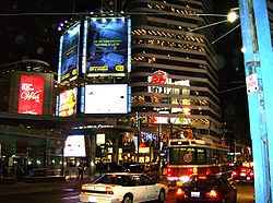
Downtown centre
Dundas Street is centrally located in downtown Toronto, about midway between Front Street
Front Street (Toronto)
Front Street is an east-west road in downtown Toronto, Ontario, Canada. The street marks the rough outline of the shoreline of Lake Ontario as it existed during the original English settlement of York, then called Palace Street...
and Bloor Street
Bloor Street
Bloor Street is a major east–west residential and commercial thoroughfare in Toronto, in the Canadian province of Ontario. Bloor Street runs from the Prince Edward Viaduct westward into Mississauga, where it ends at Central Parkway. East of the viaduct, Danforth Avenue continues along the same...
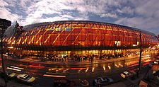
. It serves as a major east–west thoroughfare for vehicular, transit, bicycle, and pedestrian traffic downtown and beyond. Since the building of the Eaton Centre and the Yonge-Dundas Square, the intersection of Yonge and Dundas Streets has become one of the busiest intersections in the city. It is estimated that over 56 million people pass this intersection each year. To ease traffic, a pedestrian scramble
Pedestrian scramble
A pedestrian scramble, also known as a 'X' Crossing , diagonal crossing , scramble intersection , and more poetically Barnes Dance, is a pedestrian crossing system that stops all vehicular traffic and allows pedestrians to cross an intersection in every direction, including diagonally, at the same...
has been installed.
Northeast of Yonge and Dundas is the Ryerson University
Ryerson University
Ryerson University is a public research university located in downtown Toronto, Ontario, Canada. Its urban campus is adjacent to Yonge-Dundas Square located at the busiest intersection in Downtown Toronto. The majority of its buildings are in the blocks northeast of the square in Toronto's Garden...
campus. To the east of downtown, Dundas travels through the older Cabbagetown
Cabbagetown
There are two neighborhoods named Cabbagetown:*Cabbagetown , Canada*Cabbagetown , USA*Cabbagetown , a novel by Hugh Garner about Cabbagetown in Toronto and the Spanish Civil War...
neighbourhood, and the large Regent Park
Regent Park
Regent Park is a neighbourhood located in Old Toronto, Ontario, Canada. Regent Park is Canada's oldest and largest social housing project; built in the late 1940s. Formerly the centre of the Cabbagetown neighbourhood, it is bounded by Gerrard Street East to the north, River Street to the east,...
public housing project fills the block south of Dundas between Parliament Street and River Street.
Dundas Street is the address of the Art Gallery of Ontario
Art Gallery of Ontario
Under the direction of its CEO Matthew Teitelbaum, the AGO embarked on a $254 million redevelopment plan by architect Frank Gehry in 2004, called Transformation AGO. The new addition would require demolition of the 1992 Post-Modernist wing by Barton Myers and Kuwabara Payne McKenna Blumberg...
, which takes a full city block on the south side of the street, at the corner of McCaul Street, just west of University Avenue
University Avenue (Toronto)
University Avenue is a major north-south road in Downtown Toronto, Ontario, Canada. At its north end, University Avenue is the site of the Ontario Legislative Building. The eight-lane wide street is the location for several hospitals, numerous office buildings, Osgoode Hall and the Four Seasons...
. The street is also home to many other art galleries, including Bau Xi Gallery
Bau Xi Gallery
Bau-Xi Gallery is a commercial art gallery with locations in Vancouver, Toronto and Seattle. The Vancouver gallery began in 1965 and lead to a 'gallery row' on South Granville street. Its location is one of the few commercial gallery spaces designed from the ground-up to exhibit artwork...
, Art Square and Show & Tell Gallery. Just to the south of Dundas on McCaul is OCAD University.
History
The section of the street near Dundas Valley was surveyed by Augustus Jones
Augustus Jones
Augustus Jones was an American-born Upper Canadian farmer, land speculator, magistrate, militia captain and surveyor. Jones trained as a surveyor in New York City, and fled as a United Empire Loyalist to Upper Canada...
and constructed by the Queen's Rangers
Queen's Rangers
The Queen's Rangers was a military unit who fought on the Loyalist side during the American War of Independence. After the war they moved to Nova Scotia and disbanded, but were reformed again in Upper Canada before disbanding again, in 1802, a decade prior to the War of 1812.-French and Indian...
as a colonial road at the direction of John Graves Simcoe
John Graves Simcoe
John Graves Simcoe was a British army officer and the first Lieutenant Governor of Upper Canada from 1791–1796. Then frontier, this was modern-day southern Ontario and the watersheds of Georgian Bay and Lake Superior...
, first lieutenant-governor of Upper Canada
Upper Canada
The Province of Upper Canada was a political division in British Canada established in 1791 by the British Empire to govern the central third of the lands in British North America and to accommodate Loyalist refugees from the United States of America after the American Revolution...
. It connected the town of Dundas
Dundas, Ontario
Dundas is a formerly independent town and now constituent community in the city of Hamilton in Ontario, Canada. It's nickname is the Valley Town. The population has been stable for decades at about twenty thousand, largely because it has not annexed rural land from the protected Dundas Valley...
to settlements west, and also around Lake Ontario
Lake Ontario
Lake Ontario is one of the five Great Lakes of North America. It is bounded on the north and southwest by the Canadian province of Ontario, and on the south by the American state of New York. Ontario, Canada's most populous province, was named for the lake. In the Wyandot language, ontarío means...
to Niagara-on-the-Lake
Niagara-on-the-Lake
Niagara-on-the-Lake is a Canadian town located in Southern Ontario where the Niagara River meets Lake Ontario in the Niagara Region of the southern part of the province of Ontario. It is located across the Niagara river from Youngstown, New York, USA...
(Newark). The town itself was named for Henry Dundas
Henry Dundas, 1st Viscount Melville
Henry Dundas, 1st Viscount Melville PC and Baron Dunira was a Scottish lawyer and politician. He was the first Secretary of State for War and the last person to be impeached in the United Kingdom....
, Viscount Melville, British Secretary of State for the Home Department from 1791 to 1801. In the early 19th century, when Toronto's oldest streets were first named, Dundas was an important settlement in its own right, rather than simply a suburb of Hamilton
Hamilton, Ontario
Hamilton is a port city in the Canadian province of Ontario. Conceived by George Hamilton when he purchased the Durand farm shortly after the War of 1812, Hamilton has become the centre of a densely populated and industrialized region at the west end of Lake Ontario known as the Golden Horseshoe...
, as it has since become.
The road from the western end of Lake Ontario was constructed east to York in 1796. The road ended at the Humber River at Old Mill Road, following the path of today's Bloor Street within Etobicoke. An 1800 map shows Dundas connecting with the newly built Yonge Street, although the map does not show the route of this section within Toronto with any detail. An 1816 map of York shows a "Burlington Road", which was a westward extension of today's Queen Street.
Lambton Mills
The Village of Lambton Mills was a settlement at the crossing of Dundas Street and the Humber River. The settlement was on both sides of the Humber River, in both the former Etobicoke Township and York Township, within today's City of Toronto, Ontario, Canada...
. It was constructed by the militia under the supervision of George Taylor Denison. The section of today's Ossington Avenue from Queen Street north to the intersection of Dundas Street was also known as Dundas. At the time, the district along Dundas was not cleared. Montgomery's Inn
Montgomery's Inn
Montgomery's Inn is a historic home and inn in the Islington neighbourhood of Etobicoke in the city of Toronto, Ontario, Canada.Built in 1832 in a Georgian style with later additions, the inn has been restored to an 1847 period, and operates as a museum of the City of Toronto. Once in danger of...
was built on Dundas Street in 1830 for travellers along this route and also became a centre of neighbourhood business. It stands today, operated as a museum by the City of Toronto.
From Ossington Avenue to the east, Dundas was pieced together from various streets. In the latter half of the 19th century, Arthur Street was connected from Ossington Avenue and Dundas Street to Bathurst Street along the current alignment of Dundas. St. Patrick Street, the portion of today's Dundas from Bathurst Street to College Avenue (now University Avenue) bisected the Grange estate in 1877. The section from College Avenue (now University Avenue) to Yonge Street was known as Agnes Street. East of Yonge, Wilton Street, with a portion called Wilton Crescent (George Street to Sherbourne Avenue), connected to River Street. A bridge was not built over the Don River until the 20th century. The various streets were connected by jogs in the 20th century to form the current road.
In the 20th century, for purposes of efficiency, Highway 5 was redirected just west of the former village of Waterdown, Ontario
Waterdown, Ontario
Waterdown is a town in Canada which since 2001 has been a community of Hamilton, Ontario.On January 1, 2001 the new city of Hamilton was formed from the amalgamation of the Regional Municipality of Hamilton-Wentworth and its six municipalities: Hamilton, Ancaster, Dundas, Flamborough, Glanbrook,...
, and no longer passes through the town of Dundas, which was also located on the lower side of the Niagara Escarpment
Niagara Escarpment
The Niagara Escarpment is a long escarpment, or cuesta, in the United States and Canada that runs westward from New York State, through Ontario, Michigan, Wisconsin and Illinois...
.