
.gif)
Twelve Mile Creek (Ontario)
Encyclopedia
Twelve Mile Creek is a waterway located in the Niagara Peninsula
of Ontario, Canada. Its headwaters are located in the town of Pelham, Ontario
, encompassing some of the most unspoiled and natural areas of Niagara area. Its lower reaches flow through urban areas of Thorold, Ontario
and St. Catharines, Ontario
, and have been heavily altered by human activity for almost two centuries.
is located approximately 12 miles (19.3 km) from the Niagara River
. It drains a watershed of approximately 178 square kilometres (68.7 sq mi). This may be grouped into six sub-watersheds;
Of these, only the Upper Twelve Mile Creek can truly be considered to retain any significant degree of its natural state. This sub-watershed branches out into dozens of small streams and drains flowing through Short Hills Provincial Park
and St. John's Conservation Area, as well as various natural, agricultural and lightly developed areas. The area containing the headwaters is known as the Fonthill Kame Delta Complex and was formed from debris left behind by glacier
s as they retreated approximately 12000 years ago. This area has the highest elevation, and contains the only identified cold water streams identified in the Niagara region. . The area provides habitat for many bird species, including Acadian flycatcher
, Hooded warbler
, Louisiana Waterthrush
and Kentucky Warbler
.
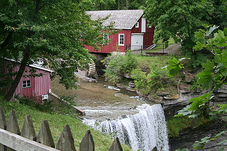 Lake Gibson is not a natural feature, but rather an artificially created reservoir. Township maps from the later half of the 19th century show a meandering stream flowing through this area (Beaverdams Creek) and plunging over the Niagara Escarpment
at Decew Falls. This is the site of Morningstar Mill (still in existence today) who used this stream for power. This stream was subsequently dammed to provide a reservoir for hydroelectric generation at the Decew Falls Generation Station. The landscape was further altered with various channels and canals to improve flow to the generating station, and with the creation of additional reservoirs. Lake Gibson receives almost all of its water supply from Lake Erie
via the Welland Canal
. This reservoir also serves as the domestic water supply for the City of St Catharines
Richardson Creek flows through mostly agricultural, but rapidly urbanizing land in the western part of St. Catharines. It is about 10.5 km in length. It combines with Francis Creek and empties into the Twelve Mile Creek at Martindale Pond, very close to its outlet. These two sub-watersheds therefore do not contribute to water flow on the great majority of the Twelve Mile Creek.
The Dicks Creek sub-watershed originates near the escarpment in a residential area, but afterwards flows into industrial and commercial areas. It flows through the abandoned second Welland Canal, passing through the stone locks which once carried ships, before entering a tunnel. It emerges from the tunnel and joins with the main branch of the Twelve Mile Creek immediately beside Highway 406, and not far from the downtown buildings of St. Catharines.
The lower portion of Twelve Mile Creek, while historically navigable as part of the second Welland Canal, is now a fast flowing river with rapids and a wide, swift water course. Almost all of the water in this portion of the creek (98 to 99%) is from the Welland Canal by way of the Decew Falls generating stations. The creek empties into Martindale Pond - a small artificial lake near the shores of Lake Ontario created to permit navigation on the first Welland Canal. This body of water also served as the route for the second and third canals and remains of locks from the second and third canals are still visible. Martindale Pond is now the site of the Royal Canadian Henley Regatta
course. The water flows over a weir into Port Dalhousie harbour, and finally out into Lake Ontario between two long piers.
 In the period following the War of 1812
, assorted mills made use of water power from various creeks which flowed over Niagara Escarpment. Among these was a sawmill and a grist mill on Twelve Mile Creek owned by William Hamilton Merritt
. Merritt's mills were plagued by low water conditions, especially in late summer - exactly when the grain harvest needed to be ground. He conceived of an idea to divert water from the Welland River
to augment the water supply. The idea of a navigable canal across the Niagara Peninsula had come up in the past and it did not take long before Merritt's idea was expanded to include such a navigable waterway . In spite of initial plans, the water source for the canal was initially the Grand River
via the Feeder Canal, as opposed to the Welland River. The modern canal receives it water directly from Lake Erie
. Twelve Mile Creek was not necessarily the best route for the canal, but it was the location of Merritt's mills, so economic motivation became a factor. Ultimately, the first two Welland Canal
s were routed via Twelve Mile Creek. The third bypassed most of the creek, but continued to use its outlet to Lake Ontario.
Early maps show that the creek meandered greatly in its lower reaches. These meanders were flooded by means of a dam at Port Dalhousie, Ontario
to create Martindale Pond. Further upstream, the first canal generally followed the bends in the creek, but most were straightened for the second canal resulting in the lower creek now being almost straight.
generating stations, the two DeCew Falls stations take their water supply from the Lake Gibson system, which is in turn fed mainly from Lake Erie via the Welland Canal. The DeCew Falls 1 station was originally put into service in 1898 and produces 23MW of power . The DeCew Falls 2 station has been in service since 1943 (unit 1) and 1948 (unit 2) and produces 144MW of power . Water from these plants is discharged into the lower Twelve Mile Creek.
 Large segments of Twelve Mile Creek are available for public access. Walking and cycling trails line most of the lower creek. Short Hills Provincial Park and St. John's Conservation Area provide both conservation and public access to the creek's upper reaches. Parks and trails are present in several areas around Lake Gibson and the Bruce Trail
crosses the upper portion of the watershed. Historic sites such as Morningstar Mill and remnants of the early Welland Canals are preserved and accessible.
The creek, however, is facing challenges from increasing urbanization and from agricultural, industrial and domestic pollution. The lower reaches are not in anything resembling a natural state, having been straightened, dredged and fed massively increased water flows. Dicks Creek flows through old stone locks and, in some areas, in tunnels. Other tributaries flow through flood control channels. Similarly, The Lake Gibson system bears little resemblance to Beaverdams Creek which once flowed through this area..
Twelve Mile Creek is a study in contrasts - in some areas, one of the most natural, and in other areas, one of the most altered watersheds in Niagara.
Niagara Peninsula
The Niagara Peninsula is the portion of Southern Ontario, Canada lying between the south shore of Lake Ontario and the north shore of Lake Erie. It stretches from the Niagara River in the east to Hamilton, Ontario in the west. The population of the peninsula is roughly 1,000,000 people...
of Ontario, Canada. Its headwaters are located in the town of Pelham, Ontario
Pelham, Ontario
The Town of Pelham is located in the centre of Niagara Region in Ontario, Canada.The town's southern boundary is formed by the Welland River, a meandering waterway that flows into the Niagara River. To the west is the township of West Lincoln, to the east the city of Welland, and to the north the...
, encompassing some of the most unspoiled and natural areas of Niagara area. Its lower reaches flow through urban areas of Thorold, Ontario
Thorold, Ontario
Thorold is a city in Ontario, Canada, located on the Niagara Escarpment. It is also the seat of the Regional Municipality of Niagara....
and St. Catharines, Ontario
St. Catharines, Ontario
St. Catharines is the largest city in Canada's Niagara Region and the sixth largest urban area in Ontario, Canada, with 97.11 square kilometres of land...
, and have been heavily altered by human activity for almost two centuries.
Watershed description
Twelve Mile Creek is named because its outlet to Lake OntarioLake Ontario
Lake Ontario is one of the five Great Lakes of North America. It is bounded on the north and southwest by the Canadian province of Ontario, and on the south by the American state of New York. Ontario, Canada's most populous province, was named for the lake. In the Wyandot language, ontarío means...
is located approximately 12 miles (19.3 km) from the Niagara River
Niagara River
The Niagara River flows north from Lake Erie to Lake Ontario. It forms part of the border between the Province of Ontario in Canada and New York State in the United States. There are differing theories as to the origin of the name of the river...
. It drains a watershed of approximately 178 square kilometres (68.7 sq mi). This may be grouped into six sub-watersheds;
- Upper Twelve Mile Creek
- Lake GibsonLake GibsonLake Gibson is a lake near Thorold, Ontario, Canada. The lake is not natural, but rather was created as a reservoir for hydroelectric power generation at the Ontario Power Generation Decew Falls 1 and Decew Falls 2 generating stations. The lake was created by flooding the shallow valley of...
System - Richardson Creek
- Francis Creek
- Dicks Creek
- Lower Twelve Mile Creek
Of these, only the Upper Twelve Mile Creek can truly be considered to retain any significant degree of its natural state. This sub-watershed branches out into dozens of small streams and drains flowing through Short Hills Provincial Park
Short Hills Provincial Park
Short Hills Provincial Park is a provincial park located in the centre of the Niagara Peninsula, bordering the city of St. Catharines and the town of Pelham in the Niagara Region in southern Ontario, Canada. It occupies an area of 6.6 km²...
and St. John's Conservation Area, as well as various natural, agricultural and lightly developed areas. The area containing the headwaters is known as the Fonthill Kame Delta Complex and was formed from debris left behind by glacier
Glacier
A glacier is a large persistent body of ice that forms where the accumulation of snow exceeds its ablation over many years, often centuries. At least 0.1 km² in area and 50 m thick, but often much larger, a glacier slowly deforms and flows due to stresses induced by its weight...
s as they retreated approximately 12000 years ago. This area has the highest elevation, and contains the only identified cold water streams identified in the Niagara region. . The area provides habitat for many bird species, including Acadian flycatcher
Acadian Flycatcher
The Acadian Flycatcher is a small insect-eating bird of the tyrant flycatcher family.- Description :Adults have olive upperparts, darker on the wings and tail, with whitish underparts; they have a white eye ring, white wing bars and a wide bill. The breast is washed with olive. The upper part of...
, Hooded warbler
Hooded Warbler
The Hooded Warbler, Wilsonia citrina, is a New World warbler. It breeds in eastern North America and across the eastern USA and into southernmost Canada, . It is migratory, wintering in Central America and the West Indies...
, Louisiana Waterthrush
Louisiana Waterthrush
The Louisiana Waterthrush is a New World warbler. It breeds in eastern North America from southernmost Canada and south through the eastern USA, excluding Florida and the coast....
and Kentucky Warbler
Kentucky Warbler
The Kentucky Warbler, Oporornis formosus, is a small species of New World warbler. The Kentucky Warbler, like all members of the genus Oporornis, is a sluggish and heavy warbler with a short tail, preferring to spend most of its time on or near the ground, except when singing.Adult Kentucky...
.
Niagara Escarpment
The Niagara Escarpment is a long escarpment, or cuesta, in the United States and Canada that runs westward from New York State, through Ontario, Michigan, Wisconsin and Illinois...
at Decew Falls. This is the site of Morningstar Mill (still in existence today) who used this stream for power. This stream was subsequently dammed to provide a reservoir for hydroelectric generation at the Decew Falls Generation Station. The landscape was further altered with various channels and canals to improve flow to the generating station, and with the creation of additional reservoirs. Lake Gibson receives almost all of its water supply from Lake Erie
Lake Erie
Lake Erie is the fourth largest lake of the five Great Lakes in North America, and the tenth largest globally. It is the southernmost, shallowest, and smallest by volume of the Great Lakes and therefore also has the shortest average water residence time. It is bounded on the north by the...
via the Welland Canal
Welland Canal
The Welland Canal is a ship canal in Canada that extends from Port Weller, Ontario, on Lake Ontario, to Port Colborne, Ontario, on Lake Erie. As a part of the St...
. This reservoir also serves as the domestic water supply for the City of St Catharines
St. Catharines, Ontario
St. Catharines is the largest city in Canada's Niagara Region and the sixth largest urban area in Ontario, Canada, with 97.11 square kilometres of land...
Richardson Creek flows through mostly agricultural, but rapidly urbanizing land in the western part of St. Catharines. It is about 10.5 km in length. It combines with Francis Creek and empties into the Twelve Mile Creek at Martindale Pond, very close to its outlet. These two sub-watersheds therefore do not contribute to water flow on the great majority of the Twelve Mile Creek.
The Dicks Creek sub-watershed originates near the escarpment in a residential area, but afterwards flows into industrial and commercial areas. It flows through the abandoned second Welland Canal, passing through the stone locks which once carried ships, before entering a tunnel. It emerges from the tunnel and joins with the main branch of the Twelve Mile Creek immediately beside Highway 406, and not far from the downtown buildings of St. Catharines.
The lower portion of Twelve Mile Creek, while historically navigable as part of the second Welland Canal, is now a fast flowing river with rapids and a wide, swift water course. Almost all of the water in this portion of the creek (98 to 99%) is from the Welland Canal by way of the Decew Falls generating stations. The creek empties into Martindale Pond - a small artificial lake near the shores of Lake Ontario created to permit navigation on the first Welland Canal. This body of water also served as the route for the second and third canals and remains of locks from the second and third canals are still visible. Martindale Pond is now the site of the Royal Canadian Henley Regatta
Royal Canadian Henley Regatta
The Royal Canadian Henley Regatta started in 1880 as the first championship for the newly formed Canadian Amateur Rowing Association. It changed venues often until 1903, when it was decided to hold it at St. Catharines Port Dalhousie's Martindale Pond hosted by the St...
course. The water flows over a weir into Port Dalhousie harbour, and finally out into Lake Ontario between two long piers.
The early Welland Canal
War of 1812
The War of 1812 was a military conflict fought between the forces of the United States of America and those of the British Empire. The Americans declared war in 1812 for several reasons, including trade restrictions because of Britain's ongoing war with France, impressment of American merchant...
, assorted mills made use of water power from various creeks which flowed over Niagara Escarpment. Among these was a sawmill and a grist mill on Twelve Mile Creek owned by William Hamilton Merritt
William Hamilton Merritt
William Hamilton Merritt was an influential figure in the Niagara Peninsula of Upper Canada in early 19th century and one of the fathers of the Welland Canal....
. Merritt's mills were plagued by low water conditions, especially in late summer - exactly when the grain harvest needed to be ground. He conceived of an idea to divert water from the Welland River
Welland River
The Welland River is a river in the Niagara Region of southern Ontario which flows from its headwaters south of Hamilton, Ontario to empty into the Niagara River near the city of Niagara Falls, Ontario. It drains an area of 880 km²....
to augment the water supply. The idea of a navigable canal across the Niagara Peninsula had come up in the past and it did not take long before Merritt's idea was expanded to include such a navigable waterway . In spite of initial plans, the water source for the canal was initially the Grand River
Grand River (Ontario)
The Grand River is a large river in southwestern Ontario, Canada. From its source, it flows south through Grand Valley, Fergus, Elora, Waterloo, Kitchener, Cambridge, Paris, Brantford, Caledonia, and Cayuga before emptying into the north shore of Lake Erie south of Dunnville at Port Maitland...
via the Feeder Canal, as opposed to the Welland River. The modern canal receives it water directly from Lake Erie
Lake Erie
Lake Erie is the fourth largest lake of the five Great Lakes in North America, and the tenth largest globally. It is the southernmost, shallowest, and smallest by volume of the Great Lakes and therefore also has the shortest average water residence time. It is bounded on the north by the...
. Twelve Mile Creek was not necessarily the best route for the canal, but it was the location of Merritt's mills, so economic motivation became a factor. Ultimately, the first two Welland Canal
Welland Canal
The Welland Canal is a ship canal in Canada that extends from Port Weller, Ontario, on Lake Ontario, to Port Colborne, Ontario, on Lake Erie. As a part of the St...
s were routed via Twelve Mile Creek. The third bypassed most of the creek, but continued to use its outlet to Lake Ontario.
Early maps show that the creek meandered greatly in its lower reaches. These meanders were flooded by means of a dam at Port Dalhousie, Ontario
Port Dalhousie, Ontario
Port Dalhousie is a community in St. Catharines, Ontario, Canada. It is known for its waterfront appeal. It is also home to the Royal Canadian Henley Regatta and is historically significant as the terminus for the first three routes of the Welland Canal.The city's most popular beach, on the...
to create Martindale Pond. Further upstream, the first canal generally followed the bends in the creek, but most were straightened for the second canal resulting in the lower creek now being almost straight.
Hydroelectric development
Just as water once powered mills directly, it continues to power industrial and domestic uses through generation of electricity. On a significantly smaller scale than the nearby Niagara FallsNiagara Falls
The Niagara Falls, located on the Niagara River draining Lake Erie into Lake Ontario, is the collective name for the Horseshoe Falls and the adjacent American Falls along with the comparatively small Bridal Veil Falls, which combined form the highest flow rate of any waterfalls in the world and has...
generating stations, the two DeCew Falls stations take their water supply from the Lake Gibson system, which is in turn fed mainly from Lake Erie via the Welland Canal. The DeCew Falls 1 station was originally put into service in 1898 and produces 23MW of power . The DeCew Falls 2 station has been in service since 1943 (unit 1) and 1948 (unit 2) and produces 144MW of power . Water from these plants is discharged into the lower Twelve Mile Creek.
Current state of the creek
Bruce Trail
The Bruce Trail is a hiking trail in southern and central Ontario, Canada.-General:The trail follows the edge of the Niagara Escarpment, one of the thirteen UNESCO World Biosphere Reserves in Canada, for almost...
crosses the upper portion of the watershed. Historic sites such as Morningstar Mill and remnants of the early Welland Canals are preserved and accessible.
The creek, however, is facing challenges from increasing urbanization and from agricultural, industrial and domestic pollution. The lower reaches are not in anything resembling a natural state, having been straightened, dredged and fed massively increased water flows. Dicks Creek flows through old stone locks and, in some areas, in tunnels. Other tributaries flow through flood control channels. Similarly, The Lake Gibson system bears little resemblance to Beaverdams Creek which once flowed through this area..
Twelve Mile Creek is a study in contrasts - in some areas, one of the most natural, and in other areas, one of the most altered watersheds in Niagara.
Natural areas
History
- Brock University - Special Collections - Canals - Digital versions of various maps and surveys relating to the first and second canals, including the Twelve Mile Creek section.
- Morningstar Mill - A working historical gist and sawmill on a tributary to Twelve Mile Creek.
- DeCew Falls 1 Generating Station - Page by Ontario Power Generation with interesting historical notes.
Watershed plan
- Twelve Mile Creek Watershed Plan - Summary, with a link to download the full document (65MB).