

First Welland Canal
Encyclopedia
Welland Canal
The Welland Canal is a ship canal in Canada that extends from Port Weller, Ontario, on Lake Ontario, to Port Colborne, Ontario, on Lake Erie. As a part of the St...
has gone through many incarnations in its history. Today, five distinct canal-construction efforts are recognized. The retronym First Welland Canal is applied to the original canal, constructed from 1824 to 1829 and 1831 to 1833.
Pre-canal times
The Great LakesGreat Lakes
The Great Lakes are a collection of freshwater lakes located in northeastern North America, on the Canada – United States border. Consisting of Lakes Superior, Michigan, Huron, Erie, and Ontario, they form the largest group of freshwater lakes on Earth by total surface, coming in second by volume...
form an excellent navigation route into the interior of North America
North America
North America is a continent wholly within the Northern Hemisphere and almost wholly within the Western Hemisphere. It is also considered a northern subcontinent of the Americas...
. Downstream from Niagara Falls
Niagara Falls
The Niagara Falls, located on the Niagara River draining Lake Erie into Lake Ontario, is the collective name for the Horseshoe Falls and the adjacent American Falls along with the comparatively small Bridal Veil Falls, which combined form the highest flow rate of any waterfalls in the world and has...
, ships can reach the port city of Montreal
Montreal
Montreal is a city in Canada. It is the largest city in the province of Quebec, the second-largest city in Canada and the seventh largest in North America...
without encountering major difficulties. Upstream, the lakes are navigable all the way to the western end of Lake Superior
Lake Superior
Lake Superior is the largest of the five traditionally-demarcated Great Lakes of North America. It is bounded to the north by the Canadian province of Ontario and the U.S. state of Minnesota, and to the south by the U.S. states of Wisconsin and Michigan. It is the largest freshwater lake in the...
. Early on during the European settlement of North America, lack of other infrastructure made the Great Lakes the premier route to reach the interior of the continent, and later to ship materials and goods from the new frontiers.
Portage
Portage or portaging refers to the practice of carrying watercraft or cargo over land to avoid river obstacles, or between two bodies of water. A place where this carrying occurs is also called a portage; a person doing the carrying is called a porter.The English word portage is derived from the...
between Queenston, Ontario
Queenston, Ontario
Queenston is located 5 km north of Niagara Falls, Ontario in the Town of Niagara-on-the-Lake. The community is bordered by Highway 405 and the Niagara River; its location on the Niagara Escarpment led to the establishment of the now-defunct Queenston Quarry in the area...
and Chippawa
Chippawa, Ontario
Chippawa is a community located within the city of Niagara Falls, Ontario.The village was founded in 1850, and became part of the City of Niagara Falls, Ontario by amalgamation in 1970. It is located on the Canadian shore of the Niagara River about 2 km upstream from Niagara Falls. It is...
was used, but the solution was far from optimal. The cargo had to be unloaded, carried 18 km up the Niagara Escarpment
Niagara Escarpment
The Niagara Escarpment is a long escarpment, or cuesta, in the United States and Canada that runs westward from New York State, through Ontario, Michigan, Wisconsin and Illinois...
, then loaded onto different ships to continue on its way.
The relatively narrow Niagara Peninsula
Niagara Peninsula
The Niagara Peninsula is the portion of Southern Ontario, Canada lying between the south shore of Lake Ontario and the north shore of Lake Erie. It stretches from the Niagara River in the east to Hamilton, Ontario in the west. The population of the peninsula is roughly 1,000,000 people...
, situated between Lake Ontario
Lake Ontario
Lake Ontario is one of the five Great Lakes of North America. It is bounded on the north and southwest by the Canadian province of Ontario, and on the south by the American state of New York. Ontario, Canada's most populous province, was named for the lake. In the Wyandot language, ontarío means...
and Lake Erie
Lake Erie
Lake Erie is the fourth largest lake of the five Great Lakes in North America, and the tenth largest globally. It is the southernmost, shallowest, and smallest by volume of the Great Lakes and therefore also has the shortest average water residence time. It is bounded on the north by the...
, was a natural match to the idea of bypassing the Falls. Indeed, the idea of a canal across the Peninsula was examined as early as 1799, when a group headed by Robert Hamilton, a Queenston merchant, unsuccessfully petitioned the Legislative Assembly of Upper Canada
Legislative Assembly of Upper Canada
The Legislative Assembly of Upper Canada was created by the Constitutional Act of 1791. It was the elected legislature for the province of Upper Canada and functioned as the province's lower house in the Parliament of Upper Canada...
. Hamilton's plan called for a canal to be constructed between Fort Erie
Fort Erie, Ontario
Fort Erie is a town on the Niagara River in the Niagara Region, Ontario, Canada. It is located directly across the river from Buffalo, New York....
and, perhaps unsurprisingly, Queenston.
In 1816, a young man called William Hamilton Merritt
William Hamilton Merritt
William Hamilton Merritt was an influential figure in the Niagara Peninsula of Upper Canada in early 19th century and one of the fathers of the Welland Canal....
bought a rundown sawmill
Sawmill
A sawmill is a facility where logs are cut into boards.-Sawmill process:A sawmill's basic operation is much like those of hundreds of years ago; a log enters on one end and dimensional lumber exits on the other end....
on the Twelve Mile Creek
Twelve Mile Creek (Ontario)
Twelve Mile Creek is a waterway located in the Niagara Peninsula of Ontario, Canada. Its headwaters are located in the town of Pelham, Ontario, encompassing some of the most unspoiled and natural areas of Niagara area. Its lower reaches flow through urban areas of Thorold, Ontario and St...
, and added a grist mill
Gristmill
The terms gristmill or grist mill can refer either to a building in which grain is ground into flour, or to the grinding mechanism itself.- Early history :...
and a store. The Twelve flowed from its source south of the Escarpment to Lake Ontario, but its water levels varied considerably, creating difficulties for Merritt and his mills. In 1818, when the flow was especially low, Merritt pursued the idea of bringing water to his mills from the Welland River
Welland River
The Welland River is a river in the Niagara Region of southern Ontario which flows from its headwaters south of Hamilton, Ontario to empty into the Niagara River near the city of Niagara Falls, Ontario. It drains an area of 880 km²....
.
On a bigger scale, the Erie Canal
Erie Canal
The Erie Canal is a waterway in New York that runs about from Albany, New York, on the Hudson River to Buffalo, New York, at Lake Erie, completing a navigable water route from the Atlantic Ocean to the Great Lakes. The canal contains 36 locks and encompasses a total elevation differential of...
, dug from the Hudson River
Hudson River
The Hudson is a river that flows from north to south through eastern New York. The highest official source is at Lake Tear of the Clouds, on the slopes of Mount Marcy in the Adirondack Mountains. The river itself officially begins in Henderson Lake in Newcomb, New York...
through northern New York
New York
New York is a state in the Northeastern region of the United States. It is the nation's third most populous state. New York is bordered by New Jersey and Pennsylvania to the south, and by Connecticut, Massachusetts and Vermont to the east...
, was about to reach Lake Erie
Lake Erie
Lake Erie is the fourth largest lake of the five Great Lakes in North America, and the tenth largest globally. It is the southernmost, shallowest, and smallest by volume of the Great Lakes and therefore also has the shortest average water residence time. It is bounded on the north by the...
. The impending completion meant the cargo from upper Great Lakes was about to head down the canal and Hudson River to New York City
New York City
New York is the most populous city in the United States and the center of the New York Metropolitan Area, one of the most populous metropolitan areas in the world. New York exerts a significant impact upon global commerce, finance, media, art, fashion, research, technology, education, and...
, bypassing its previous destination, Montreal. At the time, a considerable rivalry existed between Montreal and New York for cargo headed to Europe via ocean-going vessels. All of these factors contributed to the construction of the Welland Canal.
Planning
In 1818, William Hamilton Merritt borrowed an instrument called a water level from Samuel Beckett, a mill owner in St. Johns. Along with George Keefer, John DeCew, and a couple of other neighbours he set out to survey a potential route for a water canal. From the headwaters of the Twelve Mile Creek near present-day AllanburgAllanburg, Ontario
Allanburg is a community within the City of Thorold, Ontario, Canada. It is located on the Welland Canal and Highway 20, both important transportation routes through the Niagara Peninsula. The two cross at a 1932-built vertical-lift bridge, numbered as Bridge 11 by the Saint Lawrence Seaway...
, they planned a line three kilometers south to meet with the Welland River. A ridge was encountered along the way, and using the instrument, the surveyors calculated it to be 10 meters high. It was actually double that height; the reason for the error is not known.
On July 4, 1818, Merritt organized a meeting in St. Catharines. The outcome was a petition sent to Upper Canada Legislature
Legislative Assembly of Upper Canada
The Legislative Assembly of Upper Canada was created by the Constitutional Act of 1791. It was the elected legislature for the province of Upper Canada and functioned as the province's lower house in the Parliament of Upper Canada...
to provide for construction of a canal between the Twelve Mile Creek and Welland River. Unlike Merritt's original water-canal plan, the petition included plans for allowing boats to cross the Niagara Escarpment. In 1823, Hiram Tibbetts, an engineer, was employed to make a formal survey for the route. He suggested to dig a channel four feet below the surface level of Welland River between present-day Port Robinson
Port Robinson, Ontario
Port Robinson is a small community in the southernmost part of Thorold, Ontario, Canada. The community is divided in half by the Welland Canal, as there is no bridge in the immediate vicinity to connect the two halves of the community. In the summer, a passenger ferry runs across the canal...
and Allanburg, and then follow the Twelve Mile Creek northwest to DeCew's Falls (where George DeCew owned a mill). There, it was suggested to descend the escarpment by an incline railway
Canal inclined plane
An inclined plane is a system used on some canals for raising boats between different water levels. Boats may be conveyed afloat, in caissons, or may be carried in cradles or slings. It can be considered as a specialised type of cable railway....
and continue along the creek to Port Dalhousie
Port Dalhousie, Ontario
Port Dalhousie is a community in St. Catharines, Ontario, Canada. It is known for its waterfront appeal. It is also home to the Royal Canadian Henley Regatta and is historically significant as the terminus for the first three routes of the Welland Canal.The city's most popular beach, on the...
to reach Lake Ontario.
On January 19, 1824, an act of the Legislature formed the Welland Canal Company, with a capitalization of $150,000 and Merritt as the financial agent. As part of his fundraising duties, he travelled extensively, including the United States
United States
The United States of America is a federal constitutional republic comprising fifty states and a federal district...
and Great Britain
Great Britain
Great Britain or Britain is an island situated to the northwest of Continental Europe. It is the ninth largest island in the world, and the largest European island, as well as the largest of the British Isles...
.
Later in 1824, a revised route was put forward for the canal. It travelled from Port Robinson to Allanburg like the previous one, but from there went north and descended the escarpment by a series of canal locks in present-day Merritton
Merritton, Ontario
thumb|right|275px|The Keg RestaurantMerritton is both a distinct community within and a council ward of St. Catharines, Ontario, Canada. It was named after William Hamilton Merritt, a prominent local entrepreneur and founder of the Welland Canal Company...
. The canal then followed a local creek before joining the Twelve Mile and continuing on to Port Dalhousie. (With this new route, John Decew, one of the original canal proponents would become an opponent, when he realised that the new route would not only bypass his property, but divert water from his mill.)
Construction
Prior to the construction of the Welland Canal, the main settlements in the area were located along Lake Ontario and Niagara River, as the interior of the Niagara Peninsula remained hard to reach and rural areas, if that. As the construction progressed, however, shantytowns to house the labourers and their families were established along the way, giving birth to communities that later became Port Dalhousie
Port Dalhousie, Ontario
Port Dalhousie is a community in St. Catharines, Ontario, Canada. It is known for its waterfront appeal. It is also home to the Royal Canadian Henley Regatta and is historically significant as the terminus for the first three routes of the Welland Canal.The city's most popular beach, on the...
, Merritton
Merritton, Ontario
thumb|right|275px|The Keg RestaurantMerritton is both a distinct community within and a council ward of St. Catharines, Ontario, Canada. It was named after William Hamilton Merritt, a prominent local entrepreneur and founder of the Welland Canal Company...
, Thorold
Thorold, Ontario
Thorold is a city in Ontario, Canada, located on the Niagara Escarpment. It is also the seat of the Regional Municipality of Niagara....
, Allanburg
Allanburg, Ontario
Allanburg is a community within the City of Thorold, Ontario, Canada. It is located on the Welland Canal and Highway 20, both important transportation routes through the Niagara Peninsula. The two cross at a 1932-built vertical-lift bridge, numbered as Bridge 11 by the Saint Lawrence Seaway...
and Port Robinson
Port Robinson, Ontario
Port Robinson is a small community in the southernmost part of Thorold, Ontario, Canada. The community is divided in half by the Welland Canal, as there is no bridge in the immediate vicinity to connect the two halves of the community. In the summer, a passenger ferry runs across the canal...
.
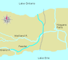
As the Deep Cut progressed, plans were being made for an alternate route to Lake Erie. The original motivation behind the canal was to bring water to mills, and this was met by constructing a canal to the Welland River. However, as the plans evolved to include a ship route, they were accommodated by simply following the Welland River until it emptied into the Niagara River. This was suboptimal for a number of reasons, the main one being the strong current of Niagara and the proximity of the towering Niagara Falls that made the journey hard and uncomfortable. Due to this, a second route was planned to diverge from the canal at Port Robinson. It would follow the Welland River southwest, then branch off, following Forks Creek and a 20 kilometre channel cut through present-day Wainfleet
Wainfleet, Ontario
Wainfleet is a rural township in southern Niagara Region, Ontario, Canada.There is a small and growing tourist industry, near and on Lake Erie at the southern area of Wainfleet called Long Beach...
and the Wainfleet Marsh to reach Grand River
Grand River (Ontario)
The Grand River is a large river in southwestern Ontario, Canada. From its source, it flows south through Grand Valley, Fergus, Elora, Waterloo, Kitchener, Cambridge, Paris, Brantford, Caledonia, and Cayuga before emptying into the north shore of Lake Erie south of Dunnville at Port Maitland...
and Lake Erie.
In September 1827, work on the Deep Cut was paused due to heavy rains. Many workers were transferred to construction of the canal in Wainfleet, and have made significant progress before Deep Cut work was resumed the following April.
However, the rains continued. On November 9, 1828, just two weeks' worth of work before completion of the Deep Cut, the banks of the cut near Port Robinson collapsed into the excavated channel, killing an unknown number of workers below. More landslides followed, and it soon became evident that making a cut deep enough as to use the Welland River as the source of canal water would not be possible. An alternate, sufficiently high source of water was necessary.
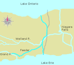
Feeder Canal
Aqueduct
An aqueduct is a water supply or navigable channel constructed to convey water. In modern engineering, the term is used for any system of pipes, ditches, canals, tunnels, and other structures used for this purpose....
would be used to cross the Welland River.
The dam was relocated eight kilometers inland by naval authorities, mindful of its safety in times not long after the War of 1812
War of 1812
The War of 1812 was a military conflict fought between the forces of the United States of America and those of the British Empire. The Americans declared war in 1812 for several reasons, including trade restrictions because of Britain's ongoing war with France, impressment of American merchant...
. The settlement by the dam later evolved into present-day Dunnville
Dunnville, Ontario
Dunnville is an unincorporated community of 6,000 people located near the mouth of the Grand River in Haldimand County, Ontario, Canada, near the historic Talbot Trail...
. From there, the Feeder went southeast to Stromness, before turning northeast in a straight cut across the Wainfleet Marsh. Interestingly, the location chosen for the aqueduct across Welland River was not Port Robinson. Although the Welland Canal and River first met in Port Robinson, it was decided to dig the canal essentially parallel to the river for a couple of kilometers upstream before crossing it. The aqueducts of three subsequent canals were later built in the same spot.
Once again, many of the Deep Cut labourers were transferred to the Feeder cut. The digging was finished in the span of 177 days, which was a large achievement at the time. Lake Erie water was let into the Feeder and Welland Canals in November 1829.
As with other locations in the peninsula, shantytowns sprung up along the Feeder Canal. These later developed into places like Dunnville, Wainfleet and Welland
Welland, Ontario
Welland is a city in the Regional Municipality of Niagara in Southern Ontario, Canada.The city has been traditionally known as the place where rails and water meet, referring to the railways from Buffalo to Toronto and Southwestern Ontario, and the waterways of Welland Canal and Welland River,...
, among others.
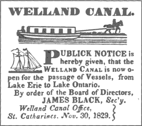
The Welland Canal was officially opened on November 30, 1829, exactly five years after the first turning of the sod. Two schooners, Annie and Jane from York, Upper Canada
York, Upper Canada
York was the name of Old Toronto between 1793 and 1834. It was the second capital of Upper Canada.- History :The town was established in 1793 by Governor John Graves Simcoe, with a new 'Fort York' on the site of the last French 'Fort Toronto'...
and R.H. Broughton from Youngstown, New York
Youngstown, New York
Youngstown is a village in Niagara County, New York, USA. The population was 1,957 at the 2000 census. It is part of the Buffalo–Niagara Falls Metropolitan Statistical Area....
, left Port Dalhousie on Lake Ontario and arrived in Buffalo
Buffalo, New York
Buffalo is the second most populous city in the state of New York, after New York City. Located in Western New York on the eastern shores of Lake Erie and at the head of the Niagara River across from Fort Erie, Ontario, Buffalo is the seat of Erie County and the principal city of the...
on the eastern end of Lake Erie two days later. Annie and Jane returned to Lake Ontario along the same route four days later.
On to Lake Erie
In March 1831, a location called Gravelly Bay (now Port Colborne
Port Colborne, Ontario
Port Colborne is a city on Lake Erie, at the southern end of the Welland Canal, in the Niagara Region of southern Ontario, Canada...
) was chosen as the new Lake Erie terminus for the canal. It was one of the closest points on the Lake Erie shore, and also offered a natural harbour for the ships waiting to enter the canal. The new part of the canal was to run in a fairly straight line, except for a stretch where it followed a local ravine and a creek to minimise required excavation of hard rock in the area.
The Welland Canal Company obtained a loan of 50,000 pounds from the Province of Upper Canada. Construction started soon after, but it was delayed by rain, difficulty in clearing land, and a cholera
Cholera
Cholera is an infection of the small intestine that is caused by the bacterium Vibrio cholerae. The main symptoms are profuse watery diarrhea and vomiting. Transmission occurs primarily by drinking or eating water or food that has been contaminated by the diarrhea of an infected person or the feces...
outbreak in 1832. Neither the Wainfleet Marsh nor the rock south of it were easy to dig in, but work was accelerated during mild weather of late 1832 and early 1833.
On June 1, 1833, the schooner Matilda, headed for Cleveland from Oakville
Oakville, Ontario
Oakville is a town in Halton Region, on Lake Ontario in Southern Ontario, Canada, and is part of the Greater Toronto Area. As of the 2006 census the population was 165,613.-History:In 1793, Dundas Street was surveyed for a military road...
, became the first ship to travel through the new channel.
Completion
Overall, the combined Welland and Feeder Canals stretched 44 kilometres (27.3 mi) between the two lakes, with 40 wooden locks. The minimum lock size was 33.5 m by 6.7 m (110 ft by 22 ft), with a minimum canal depth of 2.4 m (8 ft).Today, very little of the First Canal is evident. Much of the Feeder Canal, however is still present today in Wainfleet township
Wainfleet, Ontario
Wainfleet is a rural township in southern Niagara Region, Ontario, Canada.There is a small and growing tourist industry, near and on Lake Erie at the southern area of Wainfleet called Long Beach...
.