
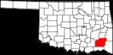
Pushmataha County, Oklahoma
Encyclopedia
Administrative History
- Ca. 1000-1500: Caddoan Mississippian civilization at Spiro Mounds
- 1492-1718: Spain
- 1718-1763: France
- 1763-1800: Spain
- 1800-1803: France
- 1803–present: United States
- 1824-1825: Miller County, Arkansas Territory (eastern portion of the county)
- 1825-1907: Choctaw Nation of Indian Territory
- 1907-present: State of Oklahoma
Prehistory and Exploration
During prehistoric times Pushmataha County was the home during the Middle Woodland periodWoodland period
The Woodland period of North American pre-Columbian cultures was from roughly 1000 BCE to 1000 CE in the eastern part of North America. The term "Woodland Period" was introduced in the 1930s as a generic header for prehistoric sites falling between the Archaic hunter-gatherers and the...
of the Fourche Maline culture
Fourche Maline culture
The Fourche Maline culture was a Woodland Period Native American culture that existed from 300 BCE to 800 CE, in southeastern Oklahoma, southwestern Arkansas, northwestern Louisiana, and northeastern Texas. They are considered to be one of the main ancestral groups of the Caddoan Mississippian...
. Over time, and possibly through contact with the Middle Mississippian culture
Mississippian culture
The Mississippian culture was a mound-building Native American culture that flourished in what is now the Midwestern, Eastern, and Southeastern United States from approximately 800 CE to 1500 CE, varying regionally....
to their northeast, the Fourche Maline became the Caddoan Mississippian culture
Caddoan Mississippian culture
The Caddoan Mississippian culture was a prehistoric Native American culture considered by archaeologists as a variant of the Mississippian culture. The Caddoan Mississippians covered a large territory, including what is now Eastern Oklahoma, Western Arkansas, Northeast Texas, and Northwest Louisiana...
. One of their most impressive sites was at Spiro Mounds
Spiro Mounds
Spiro Mounds is an important pre-Columbian Caddoan Mississippian culture archaeological site located in present-day eastern Oklahoma in the United States. The site is located seven miles north of Spiro, and is the only prehistoric Native American archaeological site in Oklahoma open to the public...
, near Spiro, Oklahoma
Spiro, Oklahoma
Spiro is a town in Le Flore County, Oklahoma, United States. It is part of the Fort Smith, Arkansas-Oklahoma Metropolitan Statistical Area. The population was 2,227 at the 2000 census.-Geography:Spiro is located at ....
, whose trade territory easily encompassed the full extent of the Kiamichi River
Kiamichi River
The Kiamichi River is a river in southeastern Oklahoma. A tributary of the Red River, its headwaters rise on Pine Mountain in the Ouachita Mountains near the Arkansas border...
and Little River
Little River (Red River)
The Little River is a tributary of the Red River, about long, in southeastern Oklahoma and southwestern Arkansas in the United States. Via the Red, it is part of the watershed of the Mississippi River.-Course:...
valleys.
North America’s history changed forever in 1492 with the arrival of Europeans under Christopher Columbus
Christopher Columbus
Christopher Columbus was an explorer, colonizer, and navigator, born in the Republic of Genoa, in northwestern Italy. Under the auspices of the Catholic Monarchs of Spain, he completed four voyages across the Atlantic Ocean that led to general European awareness of the American continents in the...
. Within decades European explorers were ranging wide and far across the North American interior, seeking fame, treasures, and conquests on behalf of their empires.
France’s Bernard de la Harpe
Bernard de la Harpe
Bernard de la Harpe or Jean-Baptiste Bénard de la Harpe was a French explorer who is credited with the discovery of Little Rock, Arkansas. In 1722, la Harpe found two distinct rock formations on the Arkansas River, the smaller one the South bank he named La Petite Roche and the larger on the North...
explored the area of the modern Pushmataha County in 1719. New Orleans was founded the year before, and with de la Harpe’s exploration France was making an imperial thrust into the Mississippi River
Mississippi River
The Mississippi River is the largest river system in North America. Flowing entirely in the United States, this river rises in western Minnesota and meanders slowly southwards for to the Mississippi River Delta at the Gulf of Mexico. With its many tributaries, the Mississippi's watershed drains...
valley seeking trade with the native peoples and also a route to New Mexico
New Mexico
New Mexico is a state located in the southwest and western regions of the United States. New Mexico is also usually considered one of the Mountain States. With a population density of 16 per square mile, New Mexico is the sixth-most sparsely inhabited U.S...
. After this time France claimed this region of North America.
The area that became Pushmataha County was bought by the United States with the Louisiana Purchase
Louisiana Purchase
The Louisiana Purchase was the acquisition by the United States of America of of France's claim to the territory of Louisiana in 1803. The U.S...
in 1803.
The first American explorer to set foot in the modern county was Major Stephen H. Long in 1817. He was followed in 1819 by Thomas Nuttall
Thomas Nuttall
Thomas Nuttall was an English botanist and zoologist, who lived and worked in America from 1808 until 1841....
, a scientist. Both explored the Kiamichi River valley, which Nuttall described in detail.
The Red River became an international boundary in 1819 when the United States concluded the Adams-Onis Treaty
Adams-Onís Treaty
The Adams–Onís Treaty of 1819, also known as the Transcontinental Treaty or the Purchase of Florida, was a treaty between the United States and Spain in 1819 that gave Florida to the U.S. and set out a boundary between the U.S. and New Spain . It settled a standing border dispute between the two...
with the Spanish Empire
Spanish Empire
The Spanish Empire comprised territories and colonies administered directly by Spain in Europe, in America, Africa, Asia and Oceania. It originated during the Age of Exploration and was therefore one of the first global empires. At the time of Habsburgs, Spain reached the peak of its world power....
. Fortifying the frontier
Frontier
A frontier is a political and geographical term referring to areas near or beyond a boundary. 'Frontier' was absorbed into English from French in the 15th century, with the meaning "borderland"--the region of a country that fronts on another country .The use of "frontier" to mean "a region at the...
from Spanish incursion, and securing it against potential uprisings by American Indians
Native Americans in the United States
Native Americans in the United States are the indigenous peoples in North America within the boundaries of the present-day continental United States, parts of Alaska, and the island state of Hawaii. They are composed of numerous, distinct tribes, states, and ethnic groups, many of which survive as...
, was important to United States policy, and it established a chain of forts along its southern border.
Fort Towson
Fort Towson
Fort Towson was a frontier outpost for Frontier Army Quartermasters along the Permanent Indian Frontier located about two miles northeast of the present community of Fort Towson, Oklahoma....
, established at the mouth of Gates Creek on the Kiamichi River, just upstream from its confluence with the Red River, was charged with providing security for the region encompassing modern Pushmataha County. Established as it was in wilderness, the U.S. Army Corps of Engineers constructed a military road connecting Fort Towson with Fort Smith, Arkansas
Fort Smith, Arkansas
Fort Smith is the second-largest city in Arkansas and one of the two county seats of Sebastian County. With a population of 86,209 in 2010, it is the principal city of the Fort Smith, Arkansas-Oklahoma Metropolitan Statistical Area, a region of 298,592 residents which encompasses the Arkansas...
for purposes of supply and provision. Its route took it through the Little River valley, and was Pushmataha County’s first modern roadway. It lapsed into disuse after Fort Towson was abandoned after the American Civil War
American Civil War
The American Civil War was a civil war fought in the United States of America. In response to the election of Abraham Lincoln as President of the United States, 11 southern slave states declared their secession from the United States and formed the Confederate States of America ; the other 25...
. Traces of it may still be seen.
The Indian Territory
Pushmataha County’s modern origins lie in the Choctaw NationChoctaw Nation of Oklahoma
The Choctaw Nation of Oklahoma is a semi-autonomous Native American homeland comprising twelve tribal districts. The Choctaw Nation maintains a special relationship with both the United States and Oklahoma governments...
, during its time as a sovereign nation in the Indian Territory
Indian Territory
The Indian Territory, also known as the Indian Territories and the Indian Country, was land set aside within the United States for the settlement of American Indians...
, prior to Oklahoma
Oklahoma
Oklahoma is a state located in the South Central region of the United States of America. With an estimated 3,751,351 residents as of the 2010 census and a land area of 68,667 square miles , Oklahoma is the 28th most populous and 20th-largest state...
statehood.
Political Organization
The Choctaw territory comprising the modern county was, until statehood in 1907, divided among two of the three administrative districts, or regions, comprising the nation – Pushmataha and Apukshunnubbee. Each of these districts was subdivided into counties. The modern county fell within Cedar County
Cedar County, Choctaw Nation
Cedar County was a political subdivision of the Choctaw Nation in the Indian Territory. The county formed part of the nation’s Apukshunnubbee District, or Second District, one of three administrative super-regions....
, Nashoba County and Wade County of the Apukshunnubbee District
Apukshunnubbee District
Apukshunnubbee District was one of three administrative super-regions comprising the former Choctaw Nation in the Indian Territory. Also called the Second District, it encompassed the southeastern one-third of the nation....
—today the county’s eastern area – and Jack’s Fork County and Kiamitia County
Kiamitia County
Kiamitia County, also known as Kiamichi County, was a political subdivision of the Choctaw Nation of Indian Territory. The county formed part of the nation’s Pushmataha District, or Third District, one of three administrative super-regions....
(Kiamichi County) of the Pushmataha District
Pushmataha District
Pushmataha District was one of three administrative super-regions comprising the former Choctaw Nation in the Indian Territory. Also called the Third District, it encompassed the southwestern one-third of the nation....
– today the county’s western area.
The War Between the States
During the American Civil War
American Civil War
The American Civil War was a civil war fought in the United States of America. In response to the election of Abraham Lincoln as President of the United States, 11 southern slave states declared their secession from the United States and formed the Confederate States of America ; the other 25...
federal troops withdrew from the Indian Territory and the Choctaw Nation allied itself with the Confederate States of America
Confederate States of America
The Confederate States of America was a government set up from 1861 to 1865 by 11 Southern slave states of the United States of America that had declared their secession from the U.S...
. The Choctaw government sent a representative to the Confederate Congress, meeting in the Confederate capital at Richmond, Virginia, and raised battalions of warriors to participate with Confederate troops.
McAlester, Oklahoma
McAlester is a city in Pittsburg County, Oklahoma, United States. The population was 17,783 at the 2000 census. It is the county seat of Pittsburg County. It is currently the largest city in the Choctaw Nation of Oklahoma, followed by Durant....
and the Battle of Middle Boggy Depot took place outside present-day Atoka
Atoka, Oklahoma
Atoka is a city in Atoka County, Oklahoma, United States. The population was 3,052 at the 2010 census. It is the county seat of Atoka County.-Geography:Atoka is located at ....
. Numerous Choctaws left their homes in the present-day county to join the battalions and participated in the Battle of Pea Ridge
Battle of Pea Ridge
The Battle of Pea Ridge was a land battle of the American Civil War, fought on March 6–8, 1862, at Pea Ridge in northwest Arkansas, near Garfield. In the battle, Union forces led by Brig. Gen. Samuel R. Curtis defeated Confederate troops under Maj. Gen. Earl Van Dorn. The outcome of the...
, in Arkansas, and at the Battle of Honey Springs
Battle of Honey Springs
The Battle of Honey Springs was an American Civil War battle, an important victory for Union forces in their efforts to gain control of the Indian Territory. The battle was also unique in the fact that white soldiers were the minority in both forces...
in the Cherokee Nation, which pitted them against a Unionist faction of Cherokee Indians.
Contemporary accounts make mention of many refugees streaming through the Kiamichi River valley. The war itself finally ended with the surrender of the last Confederate army—Cherokee General Stand Watie
Stand Watie
Stand Watie , also known as Standhope Uwatie, Degataga , meaning “stand firm”), and Isaac S. Watie, was a leader of the Cherokee Nation and a brigadier general of the Confederate States Army during the American Civil War...
's forces, who surrendered at Fort Towson
Fort Towson
Fort Towson was a frontier outpost for Frontier Army Quartermasters along the Permanent Indian Frontier located about two miles northeast of the present community of Fort Towson, Oklahoma....
in June 1865, over two months after General Robert E. Lee
Robert E. Lee
Robert Edward Lee was a career military officer who is best known for having commanded the Confederate Army of Northern Virginia in the American Civil War....
surrendered the Army of Northern Virginia
Army of Northern Virginia
The Army of Northern Virginia was the primary military force of the Confederate States of America in the Eastern Theater of the American Civil War, as well as the primary command structure of the Department of Northern Virginia. It was most often arrayed against the Union Army of the Potomac...
-- and with it any chance of Confederate success.
Sometime before 1862 a Negro slave, Wallace Willis
Wallace Willis
Uncle Wallace Willis was a Choctaw freedman living in the Indian Territory. His dates are unclear: perhaps 1820 to 1880. He is credited with composing several Negro spirituals. Willis received his name from his owner, Britt Willis, probably in Mississippi, the ancestral home of the Choctaws...
, composed the Negro spiritual "Swing Low, Sweet Chariot
Swing Low, Sweet Chariot
"Swing Low, Sweet Chariot" is a historic African-American spiritual. The first recording was in 1909, by the Fisk Jubilee Singers of Fisk University....
". He did so while working at Spencer Academy, a Choctaw Nation boarding school located at Spencervile, Indian Territory
Spencerville, Oklahoma
Spencerville is a community in northern Choctaw County, Oklahoma, 12 miles northeast of Hugo, Oklahoma, adjacent to the Pushmataha County border....
. The site of the academy and old Spencerville was located less than 1,000 yards from the current southern border of Pushmataha County, and it is entirely possible Uncle Wallace resided in Pushmataha County. He died in present-day Atoka County
Atoka County, Oklahoma
Atoka County is a county located in the U.S. state of Oklahoma, and was formed in 1907 from Choctaw Lands. As of 2000, the population is 13,879. Its county seat is Atoka.-Geography:...
and is buried in an unmarked grave.
Railroad through the Wilderness
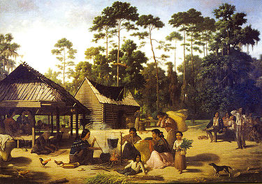
The Choctaw people were sedentary. Their lives were tied to their farms and small acreages. The Choctaw Nation was not home to industry of any sort. As a result the territory comprising modern-day Pushmataha County was still virgin wilderness decades after the Choctaws’ arrival.
This changed during the 1880s when the St. Louis and San Francisco Railroad – popularly known as the Frisco—built a line from Fort Smith, Arkansas
Fort Smith, Arkansas
Fort Smith is the second-largest city in Arkansas and one of the two county seats of Sebastian County. With a population of 86,209 in 2010, it is the principal city of the Fort Smith, Arkansas-Oklahoma Metropolitan Statistical Area, a region of 298,592 residents which encompasses the Arkansas...
to Paris, Texas
Paris, Texas
Paris, Texas is a city located northeast of the Dallas–Fort Worth Metroplex in Lamar County, Texas, in the United States. It is situated in Northeast Texas at the western edge of the Piney Woods. Physiographically, these regions are part of the West Gulf Coastal Plain. In 1900, 9,358 people lived...
. Station stops were established every few miles, both to aid in opening the land and also to serve the railroad.
The Frisco’s route took it down the Kiamichi River valley, entering the present-day county near Albion
Albion, Oklahoma
Albion is a town in Pushmataha County, Oklahoma, United States. The population was 143 at the 2000 census.- History :A United States Post Office opened at Albion, Indian Territory on December 6, 1887 and is still in operation....
and leaving the river only at Antlers, to skirt the massive bluff on which it sits.
With the railroad came civilization, and concrete ties to the outside world. The telegraph came hand-in-hand with the railroad, providing instantaneous news of events outside the Choctaw Nation.
Logging companies opened operations immediately. Rough-and-tumble sawmill communities began growing up around the railroad station stops. Kosoma
Kosoma, Oklahoma
Kosoma is a settlement and former railroad station in Pushmataha County, Oklahoma, United States. It is located just off Oklahoma State Highway 2, about north of Antlers.-Geography:...
, a veritable boomtown, boasted several hotels, doctors’ offices, and general stores during its heyday.
During the next few decades loggers harvested the entire region, using the railroad stations as transshipment points. These transshipment points grew into the present-day communities of Albion, Moyers
Moyers, Oklahoma
- History :A permanent settlement has existed at the site of modern Moyers since at least the 1880s.During the 1880s the St. Louis-San Francisco Railway, more popularly known as the “Frisco”, built a line from north to south through the Choctaw Nation, connecting Fort Smith, Arkansas with Paris,...
, and Antlers. Other communities along the railroad between these points later vanished or are today only place names, such as Kellond
Kellond, Oklahoma
Kellond, Oklahoma is a settlement and former railroad station in Pushmataha County, Oklahoma. Kellond is located approximately three miles northwest of Antlers, Oklahoma on Oklahoma State Highway 2.- History :During the 1880s the St...
, Stanley
Stanley, Oklahoma
Stanley is a community in northern Pushmataha County, Oklahoma, eight miles southwest of Clayton, Oklahoma.A United States Post Office was established at Stanley, Indian Territory on August 20, 1906. It was named for William Eugene Stanley , Governor of Kansas, 1899–1903, and member of the Dawes...
and Kiamichi
Kiamichi, Oklahoma
Kiamichi is a former community in northern Pushmataha County, Oklahoma, six miles east of Tuskahoma, Oklahoma.A United States Post Office was established at Kiamichi, Indian Territory on September 27, 1887 and operated until September 14, 1962. The community and post office took its name from the...
.
For decades the Frisco constituted the greatest feat of engineering and manmade structure in Pushmataha County. Huge amounts of earth were moved and shaped to form its elevated roadbed, and numerous wooden trestles were constructed over creeks and rivers. Once in place the railroad enabled commerce and industry. And that interested the white men in the Indian Territory.
A Bid for Self-Determination
Although the Five Civilized Tribes
Five Civilized Tribes
The Five Civilized Tribes were the five Native American nations—the Cherokee, Chickasaw, Choctaw, Creek, and Seminole—that were considered civilized by Anglo-European settlers during the colonial and early federal period because they adopted many of the colonists' customs and had generally good...
of the Indian Territory opposed their incorporation within an American state, by the turn of the Twentieth Century statehood of some sort appeared inevitable. A group of leaders from all five nations – Choctaw, Cherokee, Chickasaw, Creek, and Seminole – met at Muskogee in an attempt to seize the initiative and fashion a state of the Indian Territory. Their meeting, which came to be known as the Sequoyah Constitutional Convention, established the proposed State of Sequoyah
State of Sequoyah
The State of Sequoyah was the proposed name for a state to be established in the eastern part of present-day Oklahoma. In 1905, faced by proposals to end their tribal governments, Native Americans of the Five Civilized Tribes in Indian Territory proposed such a state as a means to retain some...
.
The leaders meeting in Muskogee recognized that the counties of the Choctaw Nation, drawn to reflect easily recognizable natural landmarks such as mountain ranges and rivers, were not economically viable. Jack’s Fork County, as example – in which Antlers was located – was a vast territory whose tiny county seat was Many Springs (modern-day Daisy, Oklahoma
Daisy, Oklahoma
Daisy is a small unincorporated community in Atoka County, Oklahoma, United States, along State Highway 43. Located in the northeastern part of the county, Daisy was once a thriving community with a general store, school and other institutions. The post office was opened April 5, 1906...
). But the only commercially successful town within its boundaries was Antlers, and it was situated in its far southeastern corner.
County boundaries for the new State of Sequoyah were carefully crafted to take into account the existing towns and the range of their commercial interests. County seats were centered geographically amidst the populations of the areas they would govern.
The area comprising modern-day Pushmataha County, Oklahoma proved a particular challenge. Huge areas of its east were virtually empty of people. Its population was centered in towns along the railroad in the Kiamichi River valley. A county was eventually drawn with the crescent of the Kiamichi River valley forming its commercial heart, and it was to be called Pushmataha County, Sequoyah
Pushmataha County, Sequoyah
Pushmataha County was a proposed political subdivision created by the Sequoyah Constitutional Convention. The convention, meeting in Muskogee, Indian Territory in 1905, established the political and administrative layout of a prospective U.S. state it called the State of Sequoyah...
.
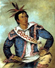
Records of the Sequoyah Constitutional Convention’s committee on counties are lost, and no evidence remains to document the committee’s deliberations. It is clear they wished to continue the Choctaw Nation’s legacy of naming an area after the revered Chief Pushmataha
Pushmataha
Pushmataha , the "Indian General", was one of the three regional chiefs of the major divisions of the Choctaw in the nineteenth century. Many historians considered him the "greatest of all Choctaw chiefs"...
, and singled out the future Pushmataha County, Sequoyah for this honor.
Then, as now, Hugo’s businesses served an area extending as far north as Kent, Speer, Hamden
Hamden, Oklahoma
Hamden is a community in northern Choctaw County, Oklahoma, seven miles southeast of Antlers, Oklahoma.A United States Post Office was established at Hamden, Indian Territory on March 31, 1894 and operated until May 15, 1924. Hamden is on the boundary separating Choctaw County and Pushmataha...
, and nearly to Rattan
Rattan, Oklahoma
Rattan is a town in Pushmataha County, Oklahoma, United States. The population was 241 at the 2000 census.-Geography:Rattan is located at...
. As a result, the county boundary for the proposed Hitchcock County
Hitchcock County, Sequoyah
Hitchcock County was a proposed political subdivision created by the Sequoyah Constitutional Convention. The convention, meeting in Muskogee, Indian Territory in 1905, established the political and administrative layout of a prospective U.S...
– with Hugo as county seat – was established along the line of the existing boundary between Choctaw and Pushmataha counties. Similar considerations governed the establishment of the county’s northern, eastern and western borders.
The United States Congress failed to admit the proposed State of Sequoyah into the Union, preferring instead to await a possible federation of the Indian Territory and Territory of Oklahoma. This was soon proposed, and in 1907 the Oklahoma Constitutional Convention met in Guthrie, Oklahoma Territory
Guthrie, Oklahoma
Guthrie is a city in and the county seat of Logan County, Oklahoma, United States, and a part of the Oklahoma City Metroplex. The population was 9,925 at the 2000 census.Guthrie was the territorial and later the first state capital for Oklahoma...
to create the new State of Oklahoma. During these deliberations it became clear that the work of the Sequoyah Constitutional Convention had been groundbreaking: the Guthrie meeting essentially adopted almost exactly the same boundaries for Pushmataha County, Oklahoma as were proposed earlier for Sequoyah, again identifying Antlers as county seat.
Since Statehood
Pushmataha County, at statehood, was considered an agricultural paradise. Local residents believed the soil to be fertile and the weather enviable and moderate… such that almost any fruit or vegetable could be grown. Most residents at the time were farmers, and lived off their land.Cotton was king, for the county’s first few decades. It was grown throughout the Kiamichi River valley. Growers hauled it into Antlers, Clayton, Albion
Albion, Oklahoma
Albion is a town in Pushmataha County, Oklahoma, United States. The population was 143 at the 2000 census.- History :A United States Post Office opened at Albion, Indian Territory on December 6, 1887 and is still in operation....
, and other places to be weighed, and shipped away to distant markets on the Frisco Railroad.
Many of the farmers or hired hands were Negroes, as African-Americans were called. The county had a significant African-American population, although this has since dwindled to almost nothing. Many made their living raising cotton, and after cotton’s decline they moved elsewhere in search of other work.
The territory comprising Pushmataha County, as it was inherited from the Choctaw Nation, was almost completely unimproved. Because the Choctaw government owned land in “severalty”, or common, and individuals did not—and because most Choctaws were a sedentary people who did not engage in industry or commerce—no bridges had been built; no road had been improved; and no public works
Public works
Public works are a broad category of projects, financed and constructed by the government, for recreational, employment, and health and safety uses in the greater community...
of any kind existed.
Early business leaders immediately sought to fund public improvements by asking voters to pass bonds. Early attempts were made to pass bridge bonds, as example, to build bridges across the Kiamichi River and Jack Fork Creek. These uniformly failed, slowing the county’s development. Choctaw County, Oklahoma
Choctaw County, Oklahoma
Choctaw County is a county located in the U.S. state of Oklahoma. As of 2000, the population was 15,342. Its county seat is Hugo.-Geography:According to the U.S. Census Bureau, the county has a total area of , of which is land and is water....
, by contrast, passed bonds almost immediately causing bridges to be built throughout the county. This proved excellent for business and commerce, and after this point Hugo grew significantly faster than Antlers.
Despite these setbacks, however, Pushmataha County grew in a healthy manner. People settled and founded communities throughout the county. Each community built its own school, and raised money with which to hire a teacher or teachers. Churches were also established. Some of the more significant communities, such as Jumbo, Moyers, Clayton and Albion, also established cultural leagues or institutions—poetry clubs, music groups, and literary societies – in a bid to be culturally couth.
Choctaw Indians continued playing a role in the region, contributing numerous elected officials and other government and society leaders in Pushmataha County. During World War I a Choctaw soldier in the U.S. Army, Tobias W. Frazier
Tobias W. Frazier
Tobias William Frazier, Sr. was a full-blood Choctaw Indian who was a member of the famous fourteen Choctaw Code Talkers. The Code Talkers pioneered the use of American Indian languages as military code during war. Their initial exploits took place during World War I, and were repeated by Native...
, a member of the famous Choctaw Code Talkers
Choctaw Code Talkers
Choctaw code talkers were a group of Choctaw Indians from Oklahoma who pioneered the use of Native American languages as military code. Their exploits took place during the waning days of . The government of the Choctaw Nation maintains these men comprised the first code talkers ever to serve in...
, was a county resident. Others were from just over the border in McCurtain County. The fourteen soldiers pioneered the use of American Indian languages as military code during war, bringing World War I to a quicker close.
The 1930s saw a lasting change across the county: the federal Works Progress Administration
Works Progress Administration
The Works Progress Administration was the largest and most ambitious New Deal agency, employing millions of unskilled workers to carry out public works projects, including the construction of public buildings and roads, and operated large arts, drama, media, and literacy projects...
(or WPA), established in response to the Great Depression
Great Depression
The Great Depression was a severe worldwide economic depression in the decade preceding World War II. The timing of the Great Depression varied across nations, but in most countries it started in about 1929 and lasted until the late 1930s or early 1940s...
, built handsome, study schools and school gymnasiums in numerous communities across the county. The new buildings were always built of native “red rock” gathered in nearby fields. They aged very well, and several are still in use, notably in Moyers, Rattan and Antlers. The school at Jumbo was bulldozed by a local farmer in the 1990s to clear the field for cattle
Cattle
Cattle are the most common type of large domesticated ungulates. They are a prominent modern member of the subfamily Bovinae, are the most widespread species of the genus Bos, and are most commonly classified collectively as Bos primigenius...
.
Another lasting change resulted from another Great Depression-era innovation, the Rural Electrification Administration. Under guidance and funding by the REA, electrical lines were strung throughout Pushmataha County, connecting homes to the electrical grid. The changes caused by electrification are hard to measure. But it is safe to say the entire social life changed as social activities moved from outdoors and downtowns to the indoors, which increasingly were artificially cooled by air conditioning
Air conditioning
An air conditioner is a home appliance, system, or mechanism designed to dehumidify and extract heat from an area. The cooling is done using a simple refrigeration cycle...
and enlivened by television. Even architecture changed, as stores, churches and homes no longer were designed to allow for maximum ventilation via the free flow of air from open windows and doors.
Highway came to be paved and standardized in the 1950s, causing transportation to be made easy and linking farms and countryside to the towns, and the towns to one another. The timing was fortunate, as the Frisco Railroad ceased passenger operations in the late 1950s and freight operations followed in the early 1980s. At that time the trestles
Trestles
Trestles is a collection of surfing spots at San Onofre State Beach in San Diego County, California. Trestles consists of, from north to south, Upper Trestles , Lower Trestles , and Middle Trestles . North of Upper Trestles is the surf spot called Cottons...
were dismantled, rails removed and its roadbed was abandoned to nature.
The Indian Nation Turnpike
Indian Nation Turnpike
The Indian Nation Turnpike is a toll road in southeastern Oklahoma. It is the longest tollway in the state.-Route description:The Indian Nation turnpike is built to parkway-like design standards, omitting a center barrier and left-hand shoulders for a slightly mounded grassy median that is flush...
, which opened in 1970, connected Antlers—its only interchange in Pushmataha County—with Oklahoma City
Oklahoma city
Oklahoma City is the capital and largest city of the U.S. state of Oklahoma.Oklahoma City may also refer to:*Oklahoma City metropolitan area*Downtown Oklahoma City*Uptown Oklahoma City*Oklahoma City bombing*Oklahoma City National Memorial...
and Tulsa.
Geography
According to the U.S. Census BureauUnited States Census Bureau
The United States Census Bureau is the government agency that is responsible for the United States Census. It also gathers other national demographic and economic data...
, the county has a total area of 3,685 km² (1,423 mi²). 3,619 km² (1,397 mi²) of it is land and 66 km² (25 mi²) of it (1.79%) is water.
Adjacent counties
- Latimer CountyLatimer County, OklahomaLatimer County is a county located in the U.S. state of Oklahoma. As of 2000, the population was 10,692. Its county seat is Wilburton.-Geography:According to the U.S. Census Bureau, the county has a total area of , of which is land and is water....
(north) - Le Flore CountyLe Flore County, OklahomaLe Flore County is a county located in the U.S. state of Oklahoma. It is part of the Fort Smith, Arkansas-Oklahoma Metropolitan Statistical Area. As of 2000, the population was 48,109. Its county seat is Poteau. The United States District Court for the Eastern District of Oklahoma is the federal...
(northeast) - McCurtain CountyMcCurtain County, OklahomaMcCurtain County is a county located in the U.S. state of Oklahoma. As of 2010, the population was 33,151. Its county seat is Idabel.-Geography:...
(east) - Choctaw CountyChoctaw County, OklahomaChoctaw County is a county located in the U.S. state of Oklahoma. As of 2000, the population was 15,342. Its county seat is Hugo.-Geography:According to the U.S. Census Bureau, the county has a total area of , of which is land and is water....
(south) - Atoka CountyAtoka County, OklahomaAtoka County is a county located in the U.S. state of Oklahoma, and was formed in 1907 from Choctaw Lands. As of 2000, the population is 13,879. Its county seat is Atoka.-Geography:...
(west) - Pittsburg CountyPittsburg County, OklahomaPittsburg County is a county located in the U.S. state of Oklahoma. As of 2000, the population was 43,953. Its county seat is McAlester.-Geography:According to the U.S. Census Bureau, the county has a total area of 3,569 km²...
(northwest)
Most of Pushmataha County is mountainous, with the exception of a relatively flat agricultural belt along the county’s southern border. The Kiamichi River valley forms a crescent through the county from northeast to southwest, and most of the human habitation has occurred inside this crescent.
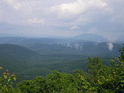
Kiamichi Mountains
The Kiamichi Mountains are a mountain range in southeastern Oklahoma. A subrange within the larger Ouachita Mountains that extend from Oklahoma to western Arkansas, the Kiamichi Mountains sit within Le Flore, Pushmataha, and McCurtain counties near the towns of Poteau and Albion...
, a sub-range of the Ouachita Mountains
Ouachita Mountains
The Ouachita Mountains are a mountain range in west central Arkansas and southeastern Oklahoma. The range's subterranean roots may extend as far as central Texas, or beyond it to the current location of the Marathon Uplift. Along with the Ozark Mountains, the Ouachita Mountains form the U.S...
, occupy most of the land in the county. This mountain chain has never been formally defined, nor have its neighboring mountain chains, such as the Winding Stair Mountains to the county’s north or the Bok Tuklo Mountains to its east. The Kiamichi Mountains range to a height of approximately 1650 feet (502.9 m) in the county. Many of its summits are not in the classical, conical shape but rather are long furrows. The mountains are difficult for roads to penetrate, and large areas of the county are virtually empty of population.
Two rivers, the Kiamichi and Little River
Little River (Red River)
The Little River is a tributary of the Red River, about long, in southeastern Oklahoma and southwestern Arkansas in the United States. Via the Red, it is part of the watershed of the Mississippi River.-Course:...
, flow through the county with their numerous tributaries. Sardis Lake
Sardis Lake (Oklahoma)
Sardis Lake is a reservoir in Pushmataha County and Latimer County in Oklahoma, USA. The dam impounding the lake is located approximately north of Clayton. The lake covers with of shoreline. The lake is an impoundment of Jackfork Creek, a tributary of the Kiamichi River.The lake's normal pool...
, a flood control facility in the northeastern part of the county, impounds the waters of Jack Fork Creek. Hugo Lake
Hugo Lake
Hugo Lake is manmade lake located east of Hugo, in Choctaw County, Oklahoma, USA. It is formed by Hugo Lake Dam on the Kiamichi River upstream from the Red River. The dam is visible from U.S. Route 70, which crosses its spillway just west of Sawyer. Lake Hugo features approximately of...
, in Choctaw County, provides a similar function on the main stem of the river. It backs up the Kiamichi River northward into the county. Smaller impoundments include Clayton Lake, Nanih Waiyah Lake
Nanih Waiyah Lake
Nanih Waiya Lake is a small recreational lake in Pushmataha County, Oklahoma. It is located northeast of Tuskahoma, Oklahoma.The lake, which was built in 1958, impounds the waters of several small creeks which are Kiamichi River tributaries. It was named for Nanih Waiya, the first capital of the...
, Ozzie Cobb Lake
Ozzie Cobb Lake
Ozzie Cobb Lake is a small recreational lake in Pushmataha County, Oklahoma. It is located north of Rattan, Oklahoma.The lake, which was built in 1958, impounds the waters of Rock Creek. It is named for J. Ozzie Cobb , an area resident...
and Pine Creek Lake
Pine Creek Lake
Pine Creek Lake is a lake in McCurtain County and Pushmataha County, Oklahoma, USA. It is located east of Rattan and north of Sobol.The lake, which was built in 1969, impounds the waters of Little River, Pine Creek, and Turkey Creek. It is managed by the U.S. Army Corps of Engineers for flood...
.
Major tributaries of the Kiamichi River include Jack Fork Creek, Buck Creek
Buck Creek (Kiamichi River tributary)
Buck Creek is a stream in Pushmataha County, Oklahoma. It flows generally southward from its headwaters in the western Kiamichi Mountains to its confluence with the Kiamichi River....
, and Ten Mile Creek. Black Fork Creek and Pine Creek are the most significant tributaries of Little River.
Two areas designated for wildlife management by the State of Oklahoma may be found in the county: the Pine Creek Wildlife Management Area
Pine Creek Wildlife Management Area
Pine Creek Wildlife Management Area is a scientifically managed preserve of natural and native wildlife flora and fauna. It is located in Pushmataha County and McCurtain County, Oklahoma, adjacent to Pine Creek Lake, seven miles north of Valliant, Oklahoma.Pine Creek WMA consists of...
, in the southeastern part of the county adjacent to Pine Creek Lake, and the Pushmataha Wildlife Management Area
Pushmataha Wildlife Management Area
Pushmataha Wildlife Management Area is a scientifically managed preserve of native flora and fauna in northern Pushmataha County, Oklahoma, five miles south of Clayton, Oklahoma. It is managed by the Oklahoma Department of Wildlife Conservation....
, near Clayton. Both areas are scientifically managed, and a multi-year research project regarding species management is underway in the Pushmataha Wildlife Management Area.
Interesting geographical features in the county include Rock Town, a small region of distinctive boulders in Johns Valley
Johns Valley, Oklahoma
Johns Valley is a geographic feature and place name located in the Kiamichi Mountains in northwestern Pushmataha County, Oklahoma. The valley is formally classified by geologists as a “basin” due to its complete encirclement by mountains. - Location :...
; Umbrella Rock near Clayton
Clayton, Oklahoma
Clayton is a town in Pushmataha County, Oklahoma, United States. The population was 719 at the 2000 census.- History :Clayton was formerly known as Dexter. A United States Post Office was established at Dexter, Indian Territory on March 31, 1894...
; McKinley Rocks near Tuskahoma
Tuskahoma, Oklahoma
Tuskahoma is a community in northern Pushmataha County, Oklahoma, four miles east of Clayton, Oklahoma.-History:A United States Post Office was established at Tushka Homma, Indian Territory on February 27, 1884. On October 28, 1891, the spelling changed to Tushkahomma. On December 6, 1910 the...
; and the Potato Hills—unusually serrated landforms near Tuskahoma.
Economy
Pushmataha County has always been separated economically from the rest of Oklahoma by what the economists call the “Ouachita barrier”. The Kiamichi Mountains and the mountains to the north of them, all subranges of the Ouachita Mountains, cause commerceCommerce
While business refers to the value-creating activities of an organization for profit, commerce means the whole system of an economy that constitutes an environment for business. The system includes legal, economic, political, social, cultural, and technological systems that are in operation in any...
with points to their north to be difficult. McAlester, Oklahoma
McAlester, Oklahoma
McAlester is a city in Pittsburg County, Oklahoma, United States. The population was 17,783 at the 2000 census. It is the county seat of Pittsburg County. It is currently the largest city in the Choctaw Nation of Oklahoma, followed by Durant....
, instead of being a regional trading center for Pushmataha County, instead seems very remote from it.
When the nation’s Federal Reserve System
Federal Reserve System
The Federal Reserve System is the central banking system of the United States. It was created on December 23, 1913 with the enactment of the Federal Reserve Act, largely in response to a series of financial panics, particularly a severe panic in 1907...
was established in 1911 and the country was divided into regional federal reserve districts, Pushmataha, Choctaw and McCurtain counties all fell within the jurisdiction of the Dallas Federal Reserve Bank and its regional district. The rest of Oklahoma falls within the jurisdiction of the Kansas City Federal Reserve Bank and its regional district. This dichotomy was due to what economists realized then, and remains the case—the county’s economic lifelines lie to its south.
Natural resources have always been the lifeblood of Pushmataha County.
The county is one of few in Oklahoma in which the petroleum industry
Petroleum industry
The petroleum industry includes the global processes of exploration, extraction, refining, transporting , and marketing petroleum products. The largest volume products of the industry are fuel oil and gasoline...
does not, and has never had, a major presence drilling for oil. During recent years extraction companies have drilled successfully for natural gas, and this is increasingly common.
During the later days of the Indian Territory and early statehood asphalt
Asphalt
Asphalt or , also known as bitumen, is a sticky, black and highly viscous liquid or semi-solid that is present in most crude petroleums and in some natural deposits, it is a substance classed as a pitch...
was mined at two locations: Jumbo
Jumbo, Oklahoma
Jumbo is a community in western Pushmataha County, Oklahoma, 10 miles north of Miller, Oklahoma.- History :A United States Post Office was established for Jumbo, Indian Territory on November 8, 1906...
and Sardis
Sardis, Oklahoma
Sardis was a community in northern Pushmataha County, Oklahoma, six miles northwest of Clayton, Oklahoma.A United States Post Office was established at Sardis, Indian Territory on February 20, 1905. It took its name from the nearby Sardis Indian Mission Church, which appears to have named itself...
. For a time these were economically successful, even at Jumbo, which experienced a catastrophic mine explosion in 1910 which killed numerous miners.
Monoculture
Monoculture is the agricultural practice of producing or growing one single crop over a wide area. It is also known as a way of farming practice of growing large stands of a single species. It is widely used in modern industrial agriculture and its implementation has allowed for large harvests from...
of pine trees—at the expense of any other—has been established.
During the Twentieth Century a rapidly improving transportation network enabled Pushmataha County to advance economically. At this writing one federal highway and several state highways are in operation. In addition, the Indian Nation Turnpike, a four-lane turnpike constructed to national interstate highway standards, is in operation with interchanges at Antlers and Daisy. The highways:
- Indian Nation TurnpikeIndian Nation TurnpikeThe Indian Nation Turnpike is a toll road in southeastern Oklahoma. It is the longest tollway in the state.-Route description:The Indian Nation turnpike is built to parkway-like design standards, omitting a center barrier and left-hand shoulders for a slightly mounded grassy median that is flush...
(Antlers) - Oklahoma State Highway 2 (Antlers, Kellond, Moyers, Kosoma, Dunbar, Clayton)
- Oklahoma State Highway 3 (Darwin, Antlers, Rattan, Oleta, Corinne)
- Oklahoma State Highway 43 (Adel, Clayton)
- Oklahoma State Highway 93Oklahoma State Highway 93State Highway 93 is a state highway in the U.S. state of Oklahoma. It runs north–south for 15.7 mi in southeastern Oklahoma. SH-93 has no lettered spur routes.-Route description:...
(Rattan, Hugo) - Oklahoma State Highway 144 (Albion, Nolia, Fewell, Honobia)
- U.S. Highway 271 (Antlers, Finley, Snow, Nashoba, Clayton, Tuskahoma, Albion)
Climate
Pushmataha County, located at the heart of “Tornado AlleyTornado Alley
Tornado Alley is a colloquial and popular media term that most often refers to the area of the United States where tornadoes are most frequent. Although an official location is not defined, the area between the Rocky Mountains and Appalachian Mountains is usually associated with it.The areas...
”, has a sometimes turbulent and often capricious climate.
High temperatures range during summer as high as 100 degrees F., often for several or more days in a row. Low temperatures during the winter can range as far as the single digits, but these “cold snaps” are rare and short-lived.
Rainfall varies across the county. Its easternmost area, in the vicinity of Honobia and north of Cloudy, receives approximately 52 inches of rain per year. Its western portions receive approximately 46 inches per year.
Snow is a rare event, and is almost never deeper than one inch. What snow falls generally melts within a day. Ice is a more frequent occurrence, sometimes breaking tree branches and downing power lines.
Tornado
Tornado
A tornado is a violent, dangerous, rotating column of air that is in contact with both the surface of the earth and a cumulonimbus cloud or, in rare cases, the base of a cumulus cloud. They are often referred to as a twister or a cyclone, although the word cyclone is used in meteorology in a wider...
season ranges from approximately April to September each year. Pushmataha County experiences powerful storms each year. A tornado striking Antlers in April 1945 devastated the town and killed 69 residents. Meteorologists now believe it to have been the most powerful category of tornado possible, and the 32nd most devastating tornado in U.S. history. Modern-day residents are protected by a civil defense system consisting of “storm spotters” stationed throughout the populated areas during threatening weather, observing the skies for signs of rotations or funnels. In Antlers a system of three public-alert sirens sounds the alarm when a funnel is spotted, allowing residents to seek shelter.
During recent decades the county has experienced unstable weather patterns. It is currently in the midst of a multi-year drought
Drought
A drought is an extended period of months or years when a region notes a deficiency in its water supply. Generally, this occurs when a region receives consistently below average precipitation. It can have a substantial impact on the ecosystem and agriculture of the affected region...
, at least as measured by local standards. Rainfall has been much below average during this time.
Demographics

Population density
Population density is a measurement of population per unit area or unit volume. It is frequently applied to living organisms, and particularly to humans...
was 3/km² (8/mi²). There were 5,795 housing units at an average density of 2/km² (4/mi²). The racial makeup of the county was 77.97% White
Race (United States Census)
Race and ethnicity in the United States Census, as defined by the Federal Office of Management and Budget and the United States Census Bureau, are self-identification data items in which residents choose the race or races with which they most closely identify, and indicate whether or not they are...
, 0.82% Black or African American, 15.59% Native American, 0.10% Asian, 0.06% Pacific Islander, 0.29% from other races, and 5.16% from two or more races. 1.64% of the population were Hispanic or Latino of any race. 96.2% spoke English, 1.7% Spanish and 1.6% Choctaw
Choctaw language
The Choctaw language, traditionally spoken by the Native American Choctaw people of the southeastern United States, is a member of the Muskogean family...
as their first language.
There were 4,739 households out of which 30.20% had children under the age of 18 living with them, 55.30% were married couples living together, 10.80% had a female householder with no husband present, and 30.60% were non-families. 27.90% of all households were made up of individuals and 14.20% had someone living alone who was 65 years of age or older. The average household size was 2.42 and the average family size was 2.94.
In the county, the population was spread out with 26.00% under the age of 18, 6.60% from 18 to 24, 24.00% from 25 to 44, 25.20% from 45 to 64, and 18.30% who were 65 years of age or older. The median age was 40 years. For every 100 females there were 92.50 males. For every 100 females age 18 and over, there were 90.40 males.
The median income for a household in the county was $22,127, and the median income for a family was $27,808. Males had a median income of $25,509 versus $17,473 for females. The per capita income
Per capita income
Per capita income or income per person is a measure of mean income within an economic aggregate, such as a country or city. It is calculated by taking a measure of all sources of income in the aggregate and dividing it by the total population...
for the county was $12,864. About 18.80% of families and 23.20% of the population were below the poverty line, including 28.70% of those under age 18 and 19.40% of those age 65 or over.
Cities and towns
|
Clayton, Oklahoma Clayton is a town in Pushmataha County, Oklahoma, United States. The population was 719 at the 2000 census.- History :Clayton was formerly known as Dexter. A United States Post Office was established at Dexter, Indian Territory on March 31, 1894... Cloudy, Oklahoma Cloudy, Oklahoma is an unincorporated community located in Pushmataha County, Oklahoma, USA. It is 12 miles northeast of Rattan, Oklahoma.Using the Public Land Survey System in use in Oklahoma the community is located at T16-3S-R19E.... Cohn, Oklahoma Cohn is a former railroad switch and loading point on the St. Louis and San Francisco Railway in Pushmataha County, Oklahoma, nine miles south of Talihina, Oklahoma. It was named for William Cohn, gravel quarry operator... Corinne, Oklahoma Corinne is a community in southern Pushmataha County, Oklahoma, 19 miles east of Antlers, Oklahoma. Using the Public Land Survey System commonly in use in Oklahoma the community is located in T22-4S-R19E.... Council House, Oklahoma Council House, also known as the Choctaw Capitol Building, is an historic site in Pushmataha County, Oklahoma two miles north of Tuskahoma, Oklahoma. The Choctaw National Council House is located here, as well as the Old Town Cemetery of Tuskahoma.... |
Crum Creek, Oklahoma Crum Creek is a former railroad spur along the St. Louis and San Francisco Railway in Pushmataha County, Oklahoma, 14 miles southwest of Tuskahoma, Oklahoma.... Darwin, Oklahoma Darwin is a community in western Pushmataha County, Oklahoma, nine miles west of Antlers, Oklahoma. It is approximately one-half mile east of the Atoka County border.... Dela, Oklahoma Dela is a community in Pushmataha County, Oklahoma six miles southeast of Antlers, Oklahoma.A United States Post Office operated here from May 12, 1920 to October 31, 1954. It was named for Dela M. Whitaker, local schoolteacher... Dunbar, Oklahoma Dunbar is a community in Pushmataha County, Oklahoma, 17 miles north of Antlers, Oklahoma.A United States Post Office operated here from May 5, 1925 to January 15, 1956. In its early days it was a sawmill town in the Indian Territory.During the 1880s the St... Ethel, Oklahoma Ethel is a community in Pushmataha County, Oklahoma, six miles east of Antlers, Oklahoma.A United States Post Office was established at Ethel, Indian Territory on April 22, 1901 and operated until August 15, 1933. It was named for Ethel Labors, early-day resident... |
Eubanks, Oklahoma Eubanks is a former community in Pushmataha County, Oklahoma, 13 miles north of Antlers, Oklahoma.A United States Post Office was established for Eubanks, Indian Territory on February 26, 1907 and operated until April 30, 1934. It was named for William Eubanks, local lumberman. During the 1880s... Fewell, Oklahoma Fewell is a community in eastern Pushmataha County, Oklahoma.A United States Post Office operated here from November 4, 1913 to October 15, 1943. It was named for Benjamin F... Finley, Oklahoma Finley is a community in Pushmataha County, Oklahoma, 10 miles northeast of Antlers, Oklahoma.A United States Post Office was established at Finley, Indian Territory on April 30, 1903. It was named for Sidney W. Finley , local merchant and first postmaster... Gee, Oklahoma Gee is a community in Pushmataha County, Oklahoma, 11 miles southeast of Clayton, Oklahoma.A United States Post Office operated here from May 22, 1909 to November 30, 1911.... Honobia, Oklahoma Honobia is a community on the border between western LeFlore County, Oklahoma and eastern Pushmataha County, Oklahoma, 15 miles southeast of Talihina.- History :A United States Post Office was established here on August 30, 1919... |
Johns Valley, Oklahoma Johns Valley is a geographic feature and place name located in the Kiamichi Mountains in northwestern Pushmataha County, Oklahoma. The valley is formally classified by geologists as a “basin” due to its complete encirclement by mountains. - Location :... Jumbo, Oklahoma Jumbo is a community in western Pushmataha County, Oklahoma, 10 miles north of Miller, Oklahoma.- History :A United States Post Office was established for Jumbo, Indian Territory on November 8, 1906... Kellond, Oklahoma Kellond, Oklahoma is a settlement and former railroad station in Pushmataha County, Oklahoma. Kellond is located approximately three miles northwest of Antlers, Oklahoma on Oklahoma State Highway 2.- History :During the 1880s the St... Kiamichi, Oklahoma Kiamichi is a former community in northern Pushmataha County, Oklahoma, six miles east of Tuskahoma, Oklahoma.A United States Post Office was established at Kiamichi, Indian Territory on September 27, 1887 and operated until September 14, 1962. The community and post office took its name from the... Kosoma, Oklahoma Kosoma is a settlement and former railroad station in Pushmataha County, Oklahoma, United States. It is located just off Oklahoma State Highway 2, about north of Antlers.-Geography:... |
Lyceum, Oklahoma Lyceum is a former academic community in northern Pushmataha County, Oklahoma, two miles west of Tuskahoma, Oklahoma.A United States Post Office was established at Lyceum, Indian Territory on March 23, 1896 and operated until July 30, 1900... Miller, Oklahoma Miller is a community in southwestern Pushmataha County, Oklahoma, 10 miles northwest of Antlers, Oklahoma and a short distance west of Moyers, Oklahoma.... Moyers, Oklahoma - History :A permanent settlement has existed at the site of modern Moyers since at least the 1880s.During the 1880s the St. Louis-San Francisco Railway, more popularly known as the “Frisco”, built a line from north to south through the Choctaw Nation, connecting Fort Smith, Arkansas with Paris,... Nashoba, Oklahoma Nashoba is a community in Pushmataha County, Oklahoma, 11 miles southeast of Tuskahoma.A United States Post Office opened at Nashoba, Indian Territory on September 13, 1886. The community took its name from Nashoba County, Choctaw Nation. The county took its name from nashoba, the word in the... Nolia, Oklahoma Nolia is a former community in eastern Pushmataha County, Oklahoma, five miles east of Nashoba, Oklahoma.A United States Post Office operated here from October 26, 1912 to December 15, 1920. It was named for Nolia Johnson, wife of Ben F. Johnson , its first postmaster. Nolia was located in the... |
Oleta, Oklahoma Oleta is a community in southeastern Pushmataha County, Oklahoma, 15 miles east of Antlers, Oklahoma. According to the Public Land Survey System in use in Oklahoma it is located in S18-T4S-R19E.... Rattan, Oklahoma Rattan is a town in Pushmataha County, Oklahoma, United States. The population was 241 at the 2000 census.-Geography:Rattan is located at... Rodney, Oklahoma Rodney is a former community in Pushmataha County, Oklahoma, five miles north of Antlers, Oklahoma.A United States Post Office was established at Rodney, Indian Territory on June 30, 1890 and closed on July 5, 1899. The community was named for Rodney Moyer, early-day resident. It was located at... Sardis, Oklahoma Sardis was a community in northern Pushmataha County, Oklahoma, six miles northwest of Clayton, Oklahoma.A United States Post Office was established at Sardis, Indian Territory on February 20, 1905. It took its name from the nearby Sardis Indian Mission Church, which appears to have named itself... Snow, Oklahoma Snow is a community in Pushmataha County, Oklahoma, 18 miles northeast of Antlers, Oklahoma.A United States Post Office was established here on July 21, 1930. It was named for George Snow, local resident and merchant.... |
Sobol, Oklahoma Sobol is a community in southeastern Pushmataha County, Oklahoma.A United States Post Office was established here on January 21, 1911. It was named for Harry Sobol, a merchant in nearby Fort Towson, Oklahoma... Spencerville, Oklahoma Spencerville is a community in northern Choctaw County, Oklahoma, 12 miles northeast of Hugo, Oklahoma, adjacent to the Pushmataha County border.... Stanley, Oklahoma Stanley is a community in northern Pushmataha County, Oklahoma, eight miles southwest of Clayton, Oklahoma.A United States Post Office was established at Stanley, Indian Territory on August 20, 1906. It was named for William Eugene Stanley , Governor of Kansas, 1899–1903, and member of the Dawes... Tuskahoma, Oklahoma Tuskahoma is a community in northern Pushmataha County, Oklahoma, four miles east of Clayton, Oklahoma.-History:A United States Post Office was established at Tushka Homma, Indian Territory on February 27, 1884. On October 28, 1891, the spelling changed to Tushkahomma. On December 6, 1910 the... Wilson, Pushmataha County, Oklahoma Wilson was a community in Pushmataha County, Oklahoma, 12 miles north of Antlers, Oklahoma.A United States Post Office operated here from October 15, 1908 to August 15, 1910. No longer in existence, the community and its post office were named for Benjamin D. Wilson, first postmaster. More... |
Zoraya, Oklahoma Zoraya, pronounced “Zoray”, is a community in western Pushmataha County, Oklahoma, west of Miller, Oklahoma.A United States Post Office opened at Zoraya, Indian Territory on April 22, 1905 and closed on October 31, 1919.... |
NRHP sites
The following sites in Pushmataha County are listed on the National Register of Historic PlacesNational Register of Historic Places
The National Register of Historic Places is the United States government's official list of districts, sites, buildings, structures, and objects deemed worthy of preservation...
:
- Albion State BankAlbion State BankAlbion State Bank was an historic structure in Albion, Oklahoma. Albion, located amidst the rugged and rural but verdant Kiamichi Mountains, in northeastern Pushmataha County, Oklahoma....
, Albion - Antlers Frisco Depot and Antlers SpringAntlers Frisco Depot and Antlers SpringThe Frisco Depot and adjacent Antlers Spring are historic sites in Antlers, Oklahoma. The sites are a part of the National Register of Historic Places, in which they appear as a single entry.-Establishing the Railroad:...
, Antlers - Choctaw Capitol BuildingChoctaw Capitol BuildingThe Choctaw Capitol Building is a historic site in Pushmataha County, Oklahoma two miles north of Tuskahoma, Oklahoma. The Choctaw National Council House is located here, as well as the Old Town Cemetery of Tuskahoma....
, Tuskahoma - Clayton High School AuditoriumClayton High School Auditorium (Oklahoma)Clayton High School Auditorium is an historic structure serving the public school of Clayton, Oklahoma. Clayton is located in the Kiamichi Mountains of Pushmataha County, Oklahoma....
, Clayton - Fewell SchoolFewell SchoolFewell School is a historic site located in Fewell, Oklahoma. Fewell, 10 miles east of Nashoba, Oklahoma, is a rural community in the Kiamichi Mountains of Pushmataha County, Oklahoma....
, Nashoba - Mato Kosyk HouseMato Kosyk HouseThe Mato Kosyk House is a private residence in Albion, Oklahoma. It was added to the National Register of Historic Places in 1979.- Mato Kosyk :...
, Albion - Snow SchoolSnow SchoolSnow School was added to the National Register of Historic Places in 1988. It is located in the unincorporated rural community of Snow, Oklahoma, approximately 18 miles north of Antlers, Oklahoma.-History:...
, Snow
In 1984 a growing awareness of the county's rich history—encompassed by these and other historic sites—and the fact its legacy was becoming endangered—prompted a group of Antlers residents to found the Pushmataha County Historical Society
Pushmataha County Historical Society
The Pushmataha County Historical Society is a historical society devoted to collecting and preserving the history of Pushmataha County, Oklahoma...
. The society's first project was a successful initiative to obtain and preserve the Antlers Frisco Depot
Antlers Frisco Depot and Antlers Spring
The Frisco Depot and adjacent Antlers Spring are historic sites in Antlers, Oklahoma. The sites are a part of the National Register of Historic Places, in which they appear as a single entry.-Establishing the Railroad:...
. It later completed a large-scale inventory of county cemeteries, and has undertaken numerous other projects since.
A significant historical site is also located atop Big Mountain, north of Moyers
Moyers, Oklahoma
- History :A permanent settlement has existed at the site of modern Moyers since at least the 1880s.During the 1880s the St. Louis-San Francisco Railway, more popularly known as the “Frisco”, built a line from north to south through the Choctaw Nation, connecting Fort Smith, Arkansas with Paris,...
and east of Kosoma
Kosoma, Oklahoma
Kosoma is a settlement and former railroad station in Pushmataha County, Oklahoma, United States. It is located just off Oklahoma State Highway 2, about north of Antlers.-Geography:...
. During World War II two aircraft flown by British pilots from a Royal Air Force base in Texas crashed in poor weather into White Rock Mountain and Big Mountain, killing four crewmen. In 2000 the AT6 Monument
AT6 Monument
The AT6 Monument is a granite memorial to Royal Air Force cadets who were killed while on a training flight during World War II. It stands on Big Mountain, north of Moyers, Oklahoma, and was dedicated on February 20, 2000—the 58th anniversary of the deadly crashes.- Background :The United Kingdom...
was dedicated in their memory at the crash site on Big Mountain, to international acclaim.
Notable residents
- Eugene M. Bradley - namesake of Bradley International AirportBradley International AirportBradley International Airport is a joint civil-military public airport located in Windsor Locks on the border with East Granby and Suffield, in Hartford County, Connecticut, United States. It is owned by the State of Connecticut....
- Nicole DeHuffNicole DeHuffNicole Renee DeHuff was an American actress.-Early life:DeHuff was born in Antlers, Oklahoma and raised in Rattan, Stringtown and Gillham, Arkansas. She began her acting career by earning a bachelor's degree in drama from Carnegie Mellon University...
- actress - Tobias W. FrazierTobias W. FrazierTobias William Frazier, Sr. was a full-blood Choctaw Indian who was a member of the famous fourteen Choctaw Code Talkers. The Code Talkers pioneered the use of American Indian languages as military code during war. Their initial exploits took place during World War I, and were repeated by Native...
- Choctaw Code Talker - Mato KosykMato KósykMato Kosyk was a Sorbian poet and minister. He was born in Werben, Prussia, emigrated from Lower Lusatia to the United States, and died at his rural home near Albion, Oklahoma.- Youth :...
- poet - Charles C. Stephenson, Jr.Charles C. Stephenson, Jr.Charles C. Stephenson, Jr. is a petroleum industry executive and philanthropist. He was born in Antlers, Oklahoma, the son of a successful grocer. He lives in Tulsa, Oklahoma.-Education:...
- energy company CEO