

Puget Sound faults
Encyclopedia
The Puget Sound faults under the heavily populated Puget Sound region (Puget Lowland) of Washington state form a regional complex of interrelated seismogenic (earthquake-causing) geologic faults. These include (from north to south, see map) the:
(Puget Lowland) of western Washington contains the bulk of the population and economic assets of the state, and carries seven percent of the international trade of the United States. All this is at risk of earthquakes from three sources:
While the great subduction events are large and release much energy (around magnitude 9), that energy is spread over a large area, and largely centered near the coast. The energy of the somewhat smaller Benioff earthquakes is likewise diluted over a relatively large area. The largest intra-crustal earthquakes have about the same total energy (which is about one-hundredth of a subduction event), but in being closer to the surface will have more powerful shaking, and therefore more damage.
One study of seismic vulnerability of bridges in the Seattle – Tacoma area estimated that an M 7 earthquake on the Seattle or Tacoma faults would cause nearly as much damage as a M 9 subduction earthquake. Because the Seattle and Tacoma faults run directly under the biggest concentration of population and development in the region, more damage would be expected, but all of the faults reviewed here may be capable of causing severe damage locally, and disrupting the regional transportation infrastructure, including highways, railways, and pipelines. (Links with more information on various hazards can be found at Seattle Fault.)
The Puget Sound region is not just potentially seismic, it is actively seismic. Mapping from the Pacific Northwest Seismic Network shows that the bulk of the earthquakes in western Washington are concentrated in four places: in two narrow zones under Mt. Saint Helens and Mt. Rainier, along the DDMFZ, and under Puget Sound between Olympia and approximately the Southern Whidbey Island Fault. The southern limit nearly matches the southern limit of the glaciation; possibly the seismicity reflects rebound of the upper crust after being stressed by the weight of the glacial ice.
activity (since the last ice age, about 12,000 years ago). Not until 1992 was the first of the lowland faults, the Seattle Fault
, confirmed to be an actual fault with Holocene activity, and the barest minimum of its history established.
Discovery of faults has been greatly facilitated with the development of LIDAR
, a technique that can generally penetrate forest canopy and vegetation to image the actual ground surface with an unprecedented accuracy of approximately one foot (30 cm). An informal consortium of regional agencies has coordinated LIDAR mapping of much of the central Puget Lowland, which has led to discovery of numerous fault scarps which are then investigated by trenching (paleoseismology
). Marine seismic reflection surveys on Puget Sound where it cuts across the various faults have provided cross-sectional views of the structure of some of these faults, and an intense, wide-area combined on-shore/off-shore study in 1998 (Seismic Hazards Investigation in Puget Sound, or SHIPS) resulted in a three-dimensional model of much of the subsurface geometry. Aeromagnetic surveys, seismic tomography, and other studies have also contributed to locating and understanding these faults.
: material from the Earth's mantle
rises at spreading centers
, and moves out as plates of oceanic crust
which eventually are subducted under the more buoyant plates of continental crust
. Western Washington lies over the Cascadia subduction zone
, where the Juan de Fuca Plate
is subducting towards the east (see diagram, right). This is being obliquely overridden by the North American plate
coming out of the northeast, which has formed a bend in the subducting plate and in the forearc
basin above it. This bend has distorted the subducting slab into an arch that has lifted the Olympic Mountains
and prevented them from subducting. For the past 50 million years or so (since the early Eocene
epoch) these have been thrust by subduction up against the North Cascades
("fixed block" in the diagram), which sit on the North American Plate. This forms a pocket or trough – what one local geologist calls the "big hole between the mountains" – between the Cascades on the east and the Olympic Mountains
and Willapa Hills
on the west. This pocket is catching a stream of terranes (crustal blocks about 20 to 30 km thick) which the Pacific plate
is pushing up the western edge of North America, and in the process imparting a bit of clockwise rotation to southwestern Washington and most of Oregon; the result has been characterized as a train wreck. These terranes were covered by the basalts of the Crescent Formation (part of the Siletz River Volcanics
). Folding and faulting has exposed these basalts in some places (black areas in diagram); the intervening basins have been filled by various sedimentary formations, some of which have been subsequently uplifted. Glacially deposited and shaped fill covers most of the lower elevations of Puget Sound
. This is the Puget Lowland. The principal effects of this complex interplay of forces on the near-surface crust underlying the Puget Lowland are:
Further complicating this is a feature of unknown structure and origin, the Olympic-Wallowa Lineament
(OWL). This is a seemingly accidental alignment of topographic features that runs roughly east-southeast from the north side of the Olympic Peninsula to the Wallowa Mountains
in northeastern Oregon. It aligns with the West Coast fault and Queen Charlotte Fault system of strike-slip fault zones (similar to the San Andreas Fault
in California) on the west side of Vancouver Island
, but does not itself show any significant or through-going strike-slip movement. It is of interest here because the various strands of the Seattle Fault change orientation where they appear to cross the OWL, and various other features, such as the Rosedale monocline and Olympia structure, and a great many local topographical features, have parallel alignments. It may also be the original location of the Darrington—Devils Mountain Fault (the bowed fault seen here). The OWL appears to be a deep-seated structure over which the shallower crust of the Puget Lowland is being pushed, but this remains speculative.
The Hood Canal Fault (and its possible extensions) and Saddle Mountain faults to the west are believed to form the western boundary to all this. On the east, the Devils Mountain Fault connects with the south striking Darrington Fault (not shown) which runs to the OWL, and the Southern Whidbey Island Fault extends via the Rattlesnake Mountain Fault Zone (dashed line) to the OWL. South of the OWL a definite eastern boundary has not been found, with some indications it is indefinite. (E.g., the Olympia Fault is aligned with and appears to be the northernmost member of a set of faults between Olympia and Chehalis that may extend to the Columbia River, and there has been a suggestion that the Tacoma Fault may connect with the White River—Naches River fault on the east side of the Cascades.)
The uplift and basin pattern is continued to the west and southwest by the Grays Harbor Basin, Willapa Hills Uplift, and Astoria Basin, but it is not
known if these are bounded by faults in the same manner as in the Puget Sound region.
from the Eocene
epoch (about 50 million years ago), with an origin variously attributed to a seamount chain, or continental margin rifting. This "basement" rock is covered with sedimentary deposits similar to the Chuckanut Formation
, and more recent (typically Miocene
) volcanic deposits. The Seattle uplift, and possibly the Black Hills uplift, consist of Crescent Formation basalt that was exposed when it was forced up a ramp of some kind. This ramp could be either in the lower crustal blocks, or where the thrust sheet has split and one part is being forced over the next. Faults and folds may develop where the thrust sheet is being bent, or where the leading edge is thrust over softer, weaker sedimentary deposits, and breaks off and slumps.
If, as this model suggests, the various faults are interconnected within the thrust sheet, there is a possibility that one earthquake could trigger others. This prospect is especially intriguing as a possible explanation of a cluster of seismic events around 1100 years ago.
A principal finding is that "[c]rustal seismicity in the southern Puget Sound region appears to be controlled by a key block of Crescent Formation occurring just south of the Seattle fault." More particularly, the concentration of seismicity under Puget Sound south of the Seattle Fault is attributed to that area riding on single block (terrane), bounded approximately by the Seattle Fault, the Olympia structure (fault?), Hood Canal (Saddle Mountain Faults?), and vaguely east of Seattle/Tacoma. And it is suggested that the Great Seattle Quake of approximately 1100 years ago, and other coseismic events in southern Puget Sound around that time, were a single event that affected this entire block, with a magnitude of around 8, possibly triggered by an earthquake deeper in the crust.
Very little is known about the structure of the deep crust (below about 30 km), though this and other seismic tomography studies (such as ) provide tantalizing glimpses.
----
For the following reviews the primary source of information is the U.S. Geological Survey's Quaternary fault and fold database (QFFDB), which includes details of discovery, a technical description, and bibliography for each fault; a specific link is provided (where available) at the end of each section.
in the Cascade foothills due west to the northern tip of Whidbey Island
, and on towards Victoria, British Columbia
, where the DMF is believed to join the Leech River fault system at the southern end of Vancouver Island
. At Darrington it is seen to connect with the Darrington Fault, which runs nearly south 110 km to converge with the Straight Creek Fault
(SCF), and then to turn near Easton
to align with the Olympic-Wallowa Lineament
; together these are known as the Darrington—Devils Mountain Fault Zone (DDMFZ).
The Devils Mountain Fault separates two similar but distinctive ensembles of Mesozoic
(pre-Tertiary
, before the dinosaurs died) or older rock. On the north is the Helena—Haystack mélange (HH mélange, purple in the diagram at right), on the south the Western and Eastern mélange belts (WEMB, blue). There are some interesting relationships here. E.g., HH mélange rock has been found in Manastash Ridge, 110 km to the south (look for the small sliver of purple near the bottom of the diagram). Also, the sedimentary Chuckanut Formation
(part of the NWCS, green) north of the DMF correlates to the Suak and Roslyn Formations just north of Manastash Ridge. All this is explained by right-lateral strike-slip motion on the Straight Creek Fault
, which initiated about 50 to 48 Ma (millions of years ago). This is just after the terrane carrying the Olympic Mountains came into contact with the North American continent. These mélanges may have been off-shore islands or seamounts that were caught between the Olympic terrane and the North American continent, and were pushed up (obducted
) onto the latter. Other similar rock has been found at the Rimrock Lake Inlier (bottom of diagram), in the San Juan Islands, and in the Pacific Coast Complex along the West Coast Fault on the west side of Vancouver Island. It appears the entire DDMFZ and Leech River fault system was pushed onto the early continental margin from an original alignment along the OWL. This is an important observation because the Strawberry Point, Utsalady Point, Southern Whidbey Island, and various other unnamed faults lying between the DDMFZ and the OWL – all of which converge at the western end of the DDMFZ – seem to be intermediate versions of the DDMFZ.
Movement on the southern segment of the DDMFZ that converges with the SCF – the Darrington Fault – was, as on the SCF itself, right-lateral. And like the SCF, strike-slip motion died out between 44 and 41 MA (due to plutonic intrusions). But the western segment – the Devils Mountain Fault – has left-lateral movement. This is because the Olympic terrane is moving (relative to North America) northeast; its continued clockwise rotation is akin to a giant wheel rolling up the western side of the North Cascade crystalline core. The geology also suggests that the DMF is moving obliquely up a ramp that rises to the east,
The Devils Mountain Fault is seismically active, and there is evidence of Holocene
offsets. If the entire 125 km length ruptured in a single event the resulting earthquake could be as large as magnitude 7.5. However, there are indications that the fault is segmented, which might limit rupturing and earthquake magnitude.
at Dughalla Bay and north side of Ault Field (Whidbey Island Naval Air Station). Just four miles (6 km) south the city of Oak Harbor
straddles several stands of the Utsalady Point Fault (UPF) as they head roughly east-southeast towards Utsalady Point at the north end of Camano Island. And in between these two the Strawberry Point Fault (SPF) skirts the south side of Ault Field, splits into various strands that bracket Strawberry Point, and then disappear (possibly ending) under the delta of the Skagit River. Both the SPF and UPF are said to be oblique-slip transpressional; that is, the faults show both horizontal and vertical slip as the crustal blocks are pressed together. These faults also form the north and south boundaries of uplifted pre-Tertiary
rock, suggesting that the faults come together at a lower level, much like one model of the Seattle and Tacoma faults, but at a smaller scale. Marine seismic reflection surveys on either side of Whidbey Island extend the known length of these faults to at least 26 and 28 km (about 15 miles). The true length of the UPF is likely twice as long, as it forms the southern margin of an aeromagnetic high that extends another 25 km to the southeast. Trenching on the UPF (at a scarp identified by LIDAR) shows at least one and probably two Holocene earthquakes of magnitude 6.7 or more, the most recent one between AD 1550 to 1850, and possibly triggered by the 1700 Cascadia earthquake. These earthquakes probably caused tsunamis, and several nearby locations have evidence of tsunamis not correlated with other known quakes.
While there is a bit of uplifted pre-Tertiary rock between the SPF and UPF, this does not truly fit the uplift and basin pattern described above because of the small scale (2 km wide rather than around 20), and because the uplift here is entirely like a wedge being popped out between two nearly vertical faults, rather than being forced over a ramp such as is involved with the Seattle and Tacoma faults. Nor does this uplift delineate any significant basin between it and the Devils Mountain Fault. On the basis of marine seismic reflection surveying in the Strait of Juan de Fuca it has been suggested that the DMF, SPF, and UPF are structurally connected (at least in the segment crossing Whidbey Island).
, the Southern Whidbey Island Fault (SWIF) diverges from the Devils Mountain Fault (reviewed above) to strike southeast through Admiralty Inlet (past Port Townsend
) and across the southern part of Whidbey Island
, with several strands crossing to the mainland between Mukilteo
and Edmonds
. This much was known from aeromagnetic, gravitational, and marine seismic reflection data dating from 1980, and the SWIF was mapped with a length of 65 km (40 miles). Prominent aeromagnetic anomalies strongly suggested that the fault zone continued, perhaps as far as Duvall
, but this was uncertain as the SWIF is largely concealed, and the faint surface traces generally obliterated by urban development. Subsequent analysis of LIDAR and high-resolution aeromagnetic data identified possible scarps near Woodinville
which trenching has confirmed to be tectonically derived and geologically recent. By this and other work the SWIF is now believed to extend about 150 km (90 miles) from Victoria to near Fall City
(about 20 miles east of Seattle), then merging with the Rattlesnake Mountain Fault Zone.
Just west of North Bend
is Rattlesnake Mountain, a prominent ridge of uplifted rock that runs south-southeast from near Fall City to the inferred trace of the Olympic-Wallowa Lineament
. Rattlesnake Mountain is the location (and possibly a result) of the Rattlesnake Mountain Fault Zone (RMFZ; shown as a pair of dotted lines in the upper image at right, and in more detail in the map excerpt at right), a band of at least eleven faults that have been mapped to Fall City and beyond, forming the eastern edge of the Seattle Uplift and truncating the Seattle Fault. The RMFZ is generally believed to be the southerly extension of the SWIF, both fault zones being in near alignment and showing similarities of geology and right-lateral strike-slip motion. Yet the change in direction near Duvall (where the SWIF intercepts the Kingston arch, see map) from southeast to south-southeast suggests a junction of two distinct fault systems, reflecting slightly different stress regimes. The possibility of the SWIF continuing more easterly (diverging from the RMFZ) to cross the Cascades before merging with the OWL has been suggested, but detailed mapping north of Carnation has not shown that.
Continuation of the RMFZ south of the OWL has not been observed, and the authors of the latest (2009) mapping suspect it turns east and merges with the OWL This raises a bit of an issue, as the SWIF and RMFZ appear to constitute "a significant terrane boundary between basement blocks underlain by Eocene marine basalts of the Coast Range province [Crescent Formation] to the southwest and pre-Tertiary metamorphic rocks of the Cascades province to the northeast."
That is, they appear to be the contact of the Crescent Formation basalts that form the underlying basement rock west of Puget Sound with the pre-Tertiary rock of the Cascades to the east, and thus would form the structural boundary between these distinct terranes. This contact is the basis for inferring the Coast Range Boundary Fault (CRBF), which is now generally identified as the SWIF and its extension along the RMFZ. If the RMFZ turns and merges with the OWL, there is a significant question of how Crescent/Cascadia contact – the CRBF – extends to the south; this point has received scant attention. The general view (as indicated on incidental maps) is to align this contact with the Western Rainier Fault zone (discussed below). However, the WRZ is offset considerably to the west, which raises additional issues. It has also been suggested, on the basis of seismic tomography and seismological and gravity data, that Crescent/Cascadia basement contact runs beneath Seattle, and that this argues against the SWIF being that contact.
The SWIF is seismically notable in that "most seismicity in the northern Puget Sound occurs along and southwest of the southern Whidbey Island fault at typical depths of 15–27 km within the lower part of the Crescent Formation." Also notable is that in the first 38 years of instrumental recording there have been essentially no shallow (less than 12 km deep) earthquakes in the Everett Basin or on the section of the SWIF adjoining it.
Paleoseismological studies of the SWIF are scant. One study compared the relative elevation of two marshes on opposite sides of Whidbey Island, and determined that approximately 3,000 years ago an earthquake of M 6.5—7.0 caused 1 to 2 meters of uplift. Another study identified an unusually broad band of scarps passing between Bothell
and Snohomish
, with several scarps in the vicinity of projected sewage treatment plant showing at least four and possibly nine events on the SWIF in the last 16,400 years.
In addition to all the usual general seismic hazards, the prospect of a M 6.5+ earthquake on the SWIF is of interest in a particular regard: King County's controversial "Brightwater Treatment Facility" (a regional sewage treatment facility) is tucked between two active strands of the SWIF, with influent and effluent pipelines crossing multiple zones of disturbed ground. For the County's interpretation of the geological hazard, what they have done in mitigation and why they think it is adequate, and the anticipated impacts of a major earthquake, see the Brightwater environmental impact statements.
(Rattlesnake Mountain Fault Zone not included in QFFDB.)
and reverse faults – between lines E and F on the map – up to 7 km wide and over 70 km long that delineates the north edge of the Seattle Uplift. It stands out in regard of its east-west orientation, depth to bedrock, and hazard to an urban population center. It is the most studied fault in the region; it will be treated in somewhat greater detail.
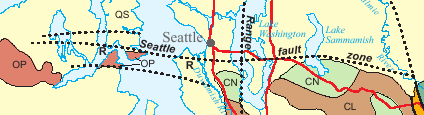 The Seattle Fault was first identified in 1965 but not documented as an active fault until 1992 with a set of five articles establishing that about 1100 years ago (AD 900—930) an earthquake of magnitude 7+ uplifted Restoration Point and Alki Point, dropped West Point (the three white triangles in the Seattle Basin on the map), caused rockslides in the Olympics, landslides into Lake Washington, and a tsunami on Puget Sound. It extends as far east as (and probably terminates at) the Rattlesnake Mountain Fault Zone (RMFZ; the southern extension of the SWIF) near Fall City
. This seems geologically reasonable, as both the SWIF and RMFZ appear to be the contact between Tertiary
Crescent Formation basement of Puget Sound on the west and the older Mesozoic
(pre-Tertiary) mélange belt basement rocks under the Cascades on the east.
An extension of some 10 km west of Hood Canal into the Olympic Mountains has been suggested on evidence that the Saddle Mountain Fault (discussed below), to the west of Hood Canal, might extend as far north as the Seattle Fault, and might be even be kinematically linked. Geologic mapping and a recent seismic reflection study shows the Seattle Fault wrapping around Green Mountain to strike southwest towards Hood Canal, and possibly joining with the Saddle Mountain Fault.
Another complication is an unusually strong north-south striking geophysical anomaly (appearing in gravitational, aeromagnetic, and seismic tomography data) that bounds the west side of the Seattle uplift (vertical black line below "D" on the map), separating it from the Dewatto Basin to the west. This appears to be a deep fault, possibly with significant vertical and horizontal offsets, which has recently (2009) been named the Tahuya Fault. To the south it appears to terminate at the Tacoma Fault; the nature of its junction with the Seattle Fault is undetermined. It is suggestively aligned with Dabob Bay, where the Hood Canal Fault is believed to strike north, but any possible connection is as yet pure speculation.
The passive roof duplex model of , relying on seismic tomography data from the "Seismic Hazards Investigation in Puget Sound" (SHIPS) experiment, retains the thrusting slab and master ramp concepts, but interprets the Tacoma fault as a reverse fault (or back thrust) that dips north towards the south dipping Seattle fault (see diagram); as a result the Seattle Uplift is being popped up like a horst
.
While these models vary in some details, both indicate that the Seattle Fault itself is capable of a magnitude 7.5 earthquake. But if the Seattle Fault should break in conjunction with other faults (discussed above), considerably more energy would be released, on the order of ~M 8.
has been described as "one of the most striking geophysical anomalies in the Puget Lowland". The western part is an active east–west striking north dipping reverse fault that separates the Seattle Uplift and the Tacoma Basin, with approximately 30 miles (50 km) of identified surface rupture. It is believed capable of generating earthquakes of at least magnitude 7, and there is evidence of such a quake approximately 1,000 years ago, possibly the same earthquake documented on the Seattle Fault 24 miles (38 km) to the north. This is likely not coincidental, as it appears that the Tacoma and Seattle faults converge at depth (see diagram above) in a way that north-south compression tends to force the Seattle Uplift up, resulting in dip-slip movement on both fault zones.
The Tacoma Fault was first identified by as a gravitational anomaly ("structure K") running east across the northern tip of Case and Carr Inlets, then southeast under Commencement Bay and towards the town of Puyallup
. Not until 2001 was it identified as a fault zone, and only in 2004 did trenching reveal Holocene
activity.
Interpretation of the eastern part of the Tacoma Fault is not entirely settled. Most authors align it with the strong gravitational anomaly (which typically reflects where faulting has juxtaposed rock of different density) and topographical lineament down Commencement Bay. This follows the front of the Rosedale monocline, a gently southwest-tilting formation that forms the bluffs on which Tacoma is built.
On the other hand, the contrasting character of the east-striking and southeast-striking segments is unsettling, and the change of direction somewhat difficult to reconcile with the observed fault traces. Especially as seismic reflection data shows some faulting continuing east across Vashon Island and the East Passage of Puget Sound (the East Passage Zone, EPZ) towards Federal Way
and an east-striking anticline. Whether the faulting continues eastward is not yet determined. The EPZ is active, being the locale of the 1995 M 5 Point Robinson earthquake.
There is evidence that the Tacoma Fault connects with the White River River Fault (WRF) via the EPZ and Federal Way
, under the Muckleshoot Basin (see map), and thence to the Naches River Fault. If so, this would be a major fault system (over 120 km long), connecting the Puget Lowland with the Yakima Fold Belt on the other side of the Cascades, with possible implications for both the Olympic—Wallowa Lineament (which it parallels) and geological structure south of the OWL.
The western end of the Tacoma Fault is curious, as near the small town of Allyn (near the extreme tip of Hood Canal) it appears to make a sharp turn to the north, and follows a strong geophysical lineament which has recently (2009) been named the Tahuya Fault. This appears to be the western termination of the Seattle Uplift. The gap between this and Hood Canal is the Dewatto Basin, which thus forms an appendage to the northwestern corner of the Tacoma Basin. One hypothesis as to how this formed is based on the regional compressive force coming not from the south, but southwest (normal to the Rosedale monocline); this raises the prospect of left-lateral strike-slip motion on the east-west oriented parts of the Tacoma and Seattle faults.
marks an abrupt change in physiography between the Puget Lowland and the Olympic Mountains
to the west. Gravitational anomalies and seismic reflection data suggest that there is a major fault zone from the south end of Hood Canal to Dabob Bay, and continuing north on land. It is inferred that if this fault is a terrane boundary between the Olympics and the Puget Lowland (but read about the Saddle Mountain Faults, below), then it must connect with various faults in the Strait of Juan de Fuca
. But whether this is via the Discovery Bay Fault, or further east (passing close to Port Townsend) remains speculative due to lack of definite scarps and paleoseismological investigation.
This fault is "largely inferred" due to a paucity of evidence. Possible Holocene movement is likewise inferred from a possible connection with the Seattle Fault, but even that connection is doubted (discussed above). Evidence is accumulating that the Saddle Mountain Faults (discussed next), which show recent activity, are the structural boundary of the Puget Lowland. Recent (2010) mapping "found no convincing evidence for the existence of this fault"; it is possible that there is no fault under Hood Canal.
Although these faults are west of the Hood Canal Fault (previously presumed to be the western boundary of the Puget Lowland), they appear to be kinematically related to the Seattle Fault: trench studies indicate major earthquakes (in the range of M 6. to 7.8) on the Saddle Mountain faults at nearly the same time (give or take a century) as the great quake on the Seattle Fault about 1100 years ago (900—930 AD). Such quakes pose a serious threat to the City of Tacoma's dams at Lake Cushman, located in the fault zone, and to everyone downstream on the Skokomish River
. The Canyon River Fault is believed to have caused a similar-sized earthquake less than 2,000 years ago; this is a particular hazard to the Wynoochee Dam
(to the west). The history and capabilities of the Frigid Creek Fault are not known.
This structure is shown in the gravitational mapping of 1965, but without comment. , labelling it "structure L", mapped it from Shelton
(near the Olympic foothills) southeast to Olympia
(pretty nearly right under the state Legislature), directly under the town of Rainier
, to a point due east of the Doty Fault, and apparently marking the northeastern limit of a band of southeast striking faults in the Centralia-Chehalis area. They interpreted it as "simple folds in Eocene bedrock", though saw sufficient similarity with the Seattle Fault to speculate that this is a thrust fault. , while observing the "remarkable straight boundaries that we interpret as evidence of structural control", refrained from calling this structure a fault. (Their model of the Black Hills Uplift is analogous with their "wedge" model of the Seattle Uplift, discussed above, but in the opposite direction. If entirely analogous, then "roof duplex" might also apply, and the Olympia Fault would be a reverse fault similar to the Tacoma Fault.)
Aeromagnetic mapping in 1999 showed a very prominent anomaly (such as typically indicates a contrast of rock type); that, along with paleoseismological evidence of a major Holocene earthquake, has led to a suggestion that this structure "may be associated with faulting". One reason for caution is that a detailed gravity survey was unable to resolve whether the Olympia structure is, or is not, a fault. Although no surface traces of faulting have been found in either the Holocene glacial sediments or the basalts of the Black Hills, on the basis of well-drilling logs a fault has been mapped striking southeast from Offut Lake (just west of Rainier); it appears to be in line with the easternmost fault mapped in the Centralia—Chehalis area.
A marine seismic reflection study found evidence of faulting at the mouth of Budd Inlet, just north of the Olympia structure, and aligning with faint lineaments seen in the lidar imagery. These faults are not quite aligned with the Olympia structure, striking N75W (285°) rather than N45W (315°). It is uncertain how these faults relate to the structure, and whether they are deep-seated faults, or fractures due to bending of the shallow crust.
It has been speculated that the OS might connect with the seismically active Saint Helens Zone (discussed below), which would imply that the OS is both locked and being stressed, raising the possibility of a major earthquake. Alternately, the OS appears to coincide with a gravitational boundary in the upper crust that has been mapped striking southeast to The Dalles on the Columbia River, where there is a swarm of similarly striking faults.
That Olympia and the south Sound are at risk of major earthquakes is shown by evidence of subsidence at several locations in southern Puget Sound some 1100 years ago. What is unknown is whether this was due to a great subduction earthquake, to the noted earthquake on the Seattle Fault
about that time, or to an earthquake on a local fault (e.g., the Olympia structure); there is some evidence that there were two earthquakes over a short time period. Subsidence dated to between AD 1445 and 1655 has been reported in Mud Bay (just east of Olympia).
(Not included in QFFDB.)
and Chehalis
in rural Lewis County may seem distant (about 25 miles) from Puget Sound, this is still part of the Puget Lowland, and these faults, the local geology, and the underlying tectonic basement seem to be connected with that immediately adjacent to Puget Sound. And though the faults in this area are not notably seismogenic, the southeast striking faults seem to be en echelon with the Olympia structure (fault?), and headed for the definitely active Saint Helens Zone; this appears to be a large scale structure. The Doty fault particularly seems to have gained prominence with geologists since it was associated with an aeromagnetic anomaly, and a report in 2000 credited it capable of a magnitude 6.7 to 7.2 earthquake. The prospect of a major earthquake on the Doty Fault poses a serious hazard to the entire Puget Sound region as it threatens vital economic lifelines: At Chehalis there is but a single freeway (Interstate 5) and a single rail line connecting the Puget Sound region with the rest of the west coast; the only alternate routes are very lengthy.
The Doty fault has been mapped from the north side of the Chehalis airport due west to the old logging town of Doty
(due north of Pe Ell), paralleled most of that distance by its twin, the Salzer Creek Fault, about half a mile to the north. Both of these are dip-slip (vertical) faults; the block between them has been popped up by compressive forces. The Doty Fault appears to terminate against, or possibly merge with, the Salzer Creek Fault at Chehalis; the Salzer Creek Fault is traced another seven miles east of Chehalis. The length of the Doty Fault is problematical: the report in 2000 gave it as 65 km (40 miles), but without comment or citation. Such a length would be comparable to the length of the Seattle or Tacoma faults, and capable of an earthquake of M 6.7. But it does not appear that there have been studies of the deeper structure of these faults, or whether there has been any recent activity.
The Doty—Salzar Creek Fault does not fully fit the regional pattern of basins and uplifts bounded by faults described above. It does bound the north side of the Chehalis basin, but the south boundary of the Black Hills Uplift is more properly the southeast striking Scammon Creek Fault that converges with the Doty—Salzar Creek Fault just north of Chehalis. In the acute angle between these is located the minor Lincoln Creek uplift, the Doty Hills, and an impressive chunk of uplifted Crescent basalt (reddish area at west edge of the map). The SE striking Scammon Creek Fault seems to be terminated by the Salzer Creek Fault (the exact relationship is not clear), with the latter continuing east for another seven miles. Yet the former is only the first of at least six more parallel southeast striking faults, which do cross the Salzer Creek Fault. These faults are: the Kopiah Fault (note the curious curve), Newaukum Fault, Coal Creek Fault, and three other unnamed faults. Just past them is the parallel Olympia Structure, which as a geophysical lineament has been traced to a point due east of Chehalis; these would seem to be related somehow, but the nature of that relationship is not yet known.
Though these faults have been traced for only a little ways, the southeast striking anticline
s they are associated with continue as far as Riffe Lake, near Mossy Rock. They are also on-strike with a swarm of faults on the Columbia River, bracketing The Dalles. As all of these are thrust
and reverse faults, they probably result from northeast directed regional compression. These faults also cross the Saint Helens Zone (SHZ), a deep, north-northwest trending zone of seismicity that appears to be the contact between different crustal blocks. How they might be connected is unknown.
What makes the Doty—Salzer Fault (and the short Chehalis Fault striking due east from Chehalis)
stand out from the many other faults south of Tacoma is its east-west strike; the significance of this is not known.
(Not included in QFFDB. See and Geologic Map for details.)
(see QFFDB fault map). Yet the SHZ and WRZ may be integral to the regional geology of Puget Sound, possibly revealing some deep and significant facets, and may also present significant seismic hazard.
The WRZ and SHZ are associated with the southern Washington Cascades conductor (SWCC), a formation of enhanced electrical conductivity lying roughly between Riffe Lake and Mounts St. Helens, Adams, and Rainier, with a lobe extending north (outlined in yellow, right). This formation, up to 15 km thick, is largely buried (from one to ten kilometers deep), and known mainly by magnetotellurics
and other geophysical methods. The southwestern boundary of the SWCC, where it is believed to be in near vertical contact with the Eocene basalts of the Crescent Formation, forms a good part of the 90 km (56 mile) long SHZ. On the eastern side, where the SWCC is believed to be in contact with pre-Tertiary terranes accreted to the North American craton
, matters are different. While there is a short zone (not shown) of fainter seismicity near Goat Rocks
(an old Pliocene
volcano) that may be associated with the contact, the substantially stronger seismicity of the WRZ is associated with the major Carbon River—Skate Mountain anticline. This anticline
, or uplifted fold, and the narrower width of the northern part of the SWCC, reflects an episode of compression of this formation. Of great interest here is that both the northern lobe of the SWCC and the Carbon River anticline are aligned towards Tiger Mountain
(an uplifted block of the Puget Group of sedimentary and volcanic deposits typical of the Puget Lowland) and the adjacent Raging River anticline (see map). The lowest exposed strata of Tiger Mountain, the mid-Eocene marine sediments of the Raging River formation, may be correlative with the SWCC.
Does the SHZ extend north? Though the Olympia Structure (a suspected fault) runs towards the SHZ, and delineates the northern edge of an exposed section of the Crescent Formation, it appears to be an upper crustal fold, part of a pattern of folding that extends southeast to cross the Columbia River near The Dalles, and unrelated to the mid and lower crustal SHZ. It has been speculated that the SHZ might extend under the Kitsap Peninsula (central Puget Sound), possibly involved with a section of the subducting Juan de Fuca plate that is suspected of being stuck. The implications of this are not only "the possibility of a moderate to large crustal earthquake along the SHZ", but that the tectonics under Puget Sound are more complicated than yet understood, and may involve differences in the regional stress patterns not reflected in current earthquake hazard assessments.
s and batholith
s) extending from Portland
to Glacier Peak
; it also marks the change in regional fault orientation noted above. This MSH-MR-GP lineament is believed to reflect a "long-lived deep-seated lithospheric flaw that has exerted major control on transfer of magma to the upper crust of southern Washington for approximately the last 25 [million years]"; it has been attributed to the geometry of the subducting Juan de Fuca plate
.
A parallel line ("B") about 15 miles (25 kilometers) to the west corresponds to the western limit of a zone of seismicity stretching from the WRZ to southwest of Portland. Curiously, the extension of line "B" north of the OWL is approximately the eastern limit of Puget Sound seismicity, the rest of southwestern Washington and the North Cascades being relatively aseismic (see the seismicity map, above). This line may also mark the northwestern boundary of the SWCC. North of the RMFZ it follows a topographical lineament that can be traced to Rockport (on Hwy. 20); it includes the Cherry Creek Fault Zone NNE of Carnation, location of the 1965 Duvall earthquake. Between the Cherry Creek and parallel Tokul Creek faults is a contact between formations of the Western Melange Belt. The zone between these two lines, reflecting changes in regional structure, seismicity, fault orientation, and possibly the underlying lithospheric structure, appears to be a major structural boundary in the Puget Lowland.
Also intersecting at Mount St. Helens is a NE (045°) trending line (red) of Pleistocene
(about 4 Ma) plug domes and a topographic lineament (followed in part by Highway 12). This line is the southern-most of a band of NE trending faults and topographical lineaments that extend from the Oregon coast into the North Cascades. A similar line aligns with the termination of the WRZ, SHZ, and Gales Creek Fault Zone (northwest of Portland), with faulting along the upper Nehalem River
on the Oregon coast, and a topographical contrast at the coast (between Neahkahnie Mountain
and the lower Nehalem River valley) distinct enough to be seen on the seismicity map above (due west of Portland). Other similar lineaments (such as from Astoria
to Glacier Peak) align with various topographical features and changes in fault orientation. These lineaments have been associated with possible zones of faulting in the crust and subducting plate.
These features suggest that the southern Puget Lowland is influenced by the deep crust and even the subducting Juan de Fuca plate, but the details and implications are not yet known.
(north end of the RMFZ, map) may be the source of a 1996 M 5.3 earthquake just east of Duvall. It follows a NNE trending topographical feature extending to Rockport
on Highway 20; it may coincide with a tectonic contact of formations of the Western Melange Belt.
The San Juan Island and Leach River faults crossing the southern end of Vancouver Island
are significant and undoubtably connected with the Darrington—Devils Mountain and Southern Whidbey Island faults, and certainly of particular interest to the residents of Victoria, B.C.. But their significance to the Puget Sound area is unknown.
The Little River Fault (see the QFFDB, Fault 556) is representative of an extensive zone of faults along the north side of the Olympic Peninsula and in the Strait of Juan de Fuca (likely connected with the fault systems at the south end of Vancouver Island, see fault database map), but these lie west of the crustal blocks that underlie the Puget Lowland, and again their possible impact on the Puget Sound region is unknown. One of these faults, the Sequim Fault Zone (striking east from the town of Sequim
), crosses Discovery Bay (and various possible extensions of the Hood Canal Fault) and bounds the Port Ludlow Uplift ("uplift of unknown origin" on the map); it appears to extend to the Southern Whidbey Island Fault.
An Everett Fault, running east-northeast along the bluffs between Mukilteo
and Everett
– that is, east of the SWIF and at the southern edge of the Everett Basin – has been claimed, but this does not appear to have been corroborated.
A Lofall Fault has been reported on the basis of marine seismic reflection surveying, but has not been confirmed by trenching. This fault seems to be associated with the Kingston arch anticline, and part of the uplift and basin pattern, but shortened because of the geometry of the SWIF. It is not notably seismogenic.
Although the largely unstudied White River Fault (WRF) appears to lie just outside of the Puget Lowland, it may actually connect under the Muckleshoot Basin to the East Passage Zone and the Tacoma Fault (map). This would pose significantly greater seismic hazard than currently recognized, especially as the White River Fault is believed to connect with the Naches River Fault that extends along Highway 410 on the east side of the Cascades towards Yakima.
The Straight Creek Fault
is a major structure in the North Cascades
, but has not been active for over 30 million years. Various other faults in the North Cascades are older (being offset by the Straight Creek Fault) and are unrelated to the faults in Puget Sound.
) was once proposed, but seems to have not been accepted by the geological community. A Coast Range Boundary Fault (CRBF) was inferred on the basis of differences in the basement rock to the west and east of Puget Sound (the Crescent Formation—Cascadia core contact), and arbitrarily mapped at various locations including Lake Washington; this is now generally identified, north of the OWL, with the Southern Whidbey Island Fault and its extension through the Rattlesnake Mountain Fault Zone. Whether the Rattlesnake Mountain Fault Zone extends south of the OWL is not yet known. Some authors still infer a CRBF fault south of the OWL, usually offset to the west from the Rattlesnake Mountain Fault Zone to align it with the St. Helens Zone or Western Rainier Zone (see maps and discussion). An argument has been made on the basis of seismic tomography and seismological data that the Crescent/Cascadia basement contact runs beneath Seattle but this is still conjectural.
Each of the principal Puget Lowland faults discussed here is notable largely for demonstrated or suspected seismic activity, usually a geologically recent (Holocene
) major earthquake. However, significant movements on these faults (such as the Great Seattle Quake of ~930 AD) are rare, and most seismic activity is not associated with any known fault. Seismicity sometimes occurs in zones,
such as has been observed under Mercer Island, or from downtown Seattle towards Kirkland but whether particular zones reflect undiscovered faults, or might be the source of damaging earthquakes, is generally unknown.
- Devils Mountain Fault
- Strawberry Point and Utsalady Point faults
- Southern Whidbey Island Fault (SWIF)
- Seattle Fault
- Tacoma Fault
- Hood Canal Fault
- Saddle Mountain Faults
- Olympia structure (suspected fault)
- Doty Fault
- Saint Helens Zone and Western Rainier Zone
Earthquake sources and hazard
The Puget Sound regionPuget Sound region
The Puget Sound region is an inland area of the Pacific Northwest in Washington , including Puget Sound, the Puget Sound lowlands, and the surrounding region roughly west of the Cascade Range and east of the Olympic Mountains.- History :...
(Puget Lowland) of western Washington contains the bulk of the population and economic assets of the state, and carries seven percent of the international trade of the United States. All this is at risk of earthquakes from three sources:
- A great subduction earthquake, such as the magnitudeRichter magnitude scaleThe expression Richter magnitude scale refers to a number of ways to assign a single number to quantify the energy contained in an earthquake....
M 9 1700 Cascadia earthquake, caused by slippage of the entire Cascadia subduction zoneCascadia subduction zoneThe Cascadia subduction zone is a subduction zone, a type of convergent plate boundary that stretches from northern Vancouver Island to northern California. It is a very long sloping fault that separates the Juan de Fuca and North America plates.New ocean floor is being created offshore of...
, from approximately Cape MendocinoCape MendocinoCape Mendocino located on the Lost Coast entirely within Humboldt County, California, USA, is the westernmost point on the coast of California. It has been a landmark since the 16th century when the Manila Galleons would reach the coast here following the prevailing westerlies all the way across...
in northern California to Vancouver IslandVancouver IslandVancouver Island is a large island in British Columbia, Canada. It is one of several North American locations named after George Vancouver, the British Royal Navy officer who explored the Pacific Northwest coast of North America between 1791 and 1794...
in British Columbia.
- Intraslab (Benioff zoneBenioff zoneA Wadati–Benioff zone is a deep active seismic area in a subduction zone. Differential motion along the zone produces deep-seated earthquakes, the foci of which may be as deep as about . They develop beneath volcanic island arcs and continental margins above active subduction zones...
) earthquakes, such as the M 6.7 2001 Nisqually earthquake, caused by slippage or fracturing on a small part of the subducting plate at a depth of around 50 km.
- Relatively shallow crustal earthquakes, generally less than 25 km (about 15 miles) deep, caused by stresses and faulting in the near-surface crustal structures. The energy released depends on the length of the fault; the faults here are believed capable of generating earthquakes as great as M 6 or 7.
While the great subduction events are large and release much energy (around magnitude 9), that energy is spread over a large area, and largely centered near the coast. The energy of the somewhat smaller Benioff earthquakes is likewise diluted over a relatively large area. The largest intra-crustal earthquakes have about the same total energy (which is about one-hundredth of a subduction event), but in being closer to the surface will have more powerful shaking, and therefore more damage.
One study of seismic vulnerability of bridges in the Seattle – Tacoma area estimated that an M 7 earthquake on the Seattle or Tacoma faults would cause nearly as much damage as a M 9 subduction earthquake. Because the Seattle and Tacoma faults run directly under the biggest concentration of population and development in the region, more damage would be expected, but all of the faults reviewed here may be capable of causing severe damage locally, and disrupting the regional transportation infrastructure, including highways, railways, and pipelines. (Links with more information on various hazards can be found at Seattle Fault.)
The Puget Sound region is not just potentially seismic, it is actively seismic. Mapping from the Pacific Northwest Seismic Network shows that the bulk of the earthquakes in western Washington are concentrated in four places: in two narrow zones under Mt. Saint Helens and Mt. Rainier, along the DDMFZ, and under Puget Sound between Olympia and approximately the Southern Whidbey Island Fault. The southern limit nearly matches the southern limit of the glaciation; possibly the seismicity reflects rebound of the upper crust after being stressed by the weight of the glacial ice.
Discovery
Thick glacial and other deposits, heavy vegetation, urban development, and a topography of sharp relief and rapid erosion obscures the surface expression of faults in this region, and has hindered their discovery. The first definite indications of most of these faults came from gravitational mapping in 1965, and their likely existence noted on mapping in 1980 and 1985. As of 1985 only the Saddle Mountain Faults had been shown to have HoloceneHolocene
The Holocene is a geological epoch which began at the end of the Pleistocene and continues to the present. The Holocene is part of the Quaternary period. Its name comes from the Greek words and , meaning "entirely recent"...
activity (since the last ice age, about 12,000 years ago). Not until 1992 was the first of the lowland faults, the Seattle Fault
Seattle Fault
The Seattle Fault is a zone of multiple shallow east-west thrust faults that cross the Puget Sound Lowland and through Seattle in the vicinity of Interstate Highway 90...
, confirmed to be an actual fault with Holocene activity, and the barest minimum of its history established.
Discovery of faults has been greatly facilitated with the development of LIDAR
LIDAR
LIDAR is an optical remote sensing technology that can measure the distance to, or other properties of a target by illuminating the target with light, often using pulses from a laser...
, a technique that can generally penetrate forest canopy and vegetation to image the actual ground surface with an unprecedented accuracy of approximately one foot (30 cm). An informal consortium of regional agencies has coordinated LIDAR mapping of much of the central Puget Lowland, which has led to discovery of numerous fault scarps which are then investigated by trenching (paleoseismology
Paleoseismology
Paleoseismology looks at geologic sediments and rocks, for signs of ancient earthquakes. It is used to supplement seismic monitoring, for the calculation of seismic hazard...
). Marine seismic reflection surveys on Puget Sound where it cuts across the various faults have provided cross-sectional views of the structure of some of these faults, and an intense, wide-area combined on-shore/off-shore study in 1998 (Seismic Hazards Investigation in Puget Sound, or SHIPS) resulted in a three-dimensional model of much of the subsurface geometry. Aeromagnetic surveys, seismic tomography, and other studies have also contributed to locating and understanding these faults.
Geological setting
The ultimate driver of the stresses that cause earthquakes are the motions of the tectonic platesPlate tectonics
Plate tectonics is a scientific theory that describes the large scale motions of Earth's lithosphere...
: material from the Earth's mantle
Mantle (geology)
The mantle is a part of a terrestrial planet or other rocky body large enough to have differentiation by density. The interior of the Earth, similar to the other terrestrial planets, is chemically divided into layers. The mantle is a highly viscous layer between the crust and the outer core....
rises at spreading centers
Mid-ocean ridge
A mid-ocean ridge is a general term for an underwater mountain system that consists of various mountain ranges , typically having a valley known as a rift running along its spine, formed by plate tectonics. This type of oceanic ridge is characteristic of what is known as an oceanic spreading...
, and moves out as plates of oceanic crust
Oceanic crust
Oceanic crust is the part of Earth's lithosphere that surfaces in the ocean basins. Oceanic crust is primarily composed of mafic rocks, or sima, which is rich in iron and magnesium...
which eventually are subducted under the more buoyant plates of continental crust
Continental crust
The continental crust is the layer of igneous, sedimentary, and metamorphic rocks which form the continents and the areas of shallow seabed close to their shores, known as continental shelves. This layer is sometimes called sial due to more felsic, or granitic, bulk composition, which lies in...
. Western Washington lies over the Cascadia subduction zone
Cascadia subduction zone
The Cascadia subduction zone is a subduction zone, a type of convergent plate boundary that stretches from northern Vancouver Island to northern California. It is a very long sloping fault that separates the Juan de Fuca and North America plates.New ocean floor is being created offshore of...
, where the Juan de Fuca Plate
Juan de Fuca Plate
The Juan de Fuca Plate, named after the explorer of the same name, is a tectonic plate, generated from the Juan de Fuca Ridge, and subducting under the northerly portion of the western side of the North American Plate at the Cascadia subduction zone...
is subducting towards the east (see diagram, right). This is being obliquely overridden by the North American plate
North American Plate
The North American Plate is a tectonic plate covering most of North America, Greenland, Cuba, Bahamas, and parts of Siberia, Japan and Iceland. It extends eastward to the Mid-Atlantic Ridge and westward to the Chersky Range in eastern Siberia. The plate includes both continental and oceanic crust...
coming out of the northeast, which has formed a bend in the subducting plate and in the forearc
Forearc
A forearc or forarc, also called arc-trench gap is a depression in the sea floor located between a subduction zone and an associated volcanic arc. It is typically filled with sediments from the adjacent landmass and the island arc in addition to trapped oceanic crustal material...
basin above it. This bend has distorted the subducting slab into an arch that has lifted the Olympic Mountains
Olympic Mountains
The Olympic Mountains is a mountain range on the Olympic Peninsula of western Washington in the United States. The mountains, part of the Pacific Coast Ranges, are not especially high - Mount Olympus is the highest at - but the western slopes of the Olympics rise directly out of the Pacific...
and prevented them from subducting. For the past 50 million years or so (since the early Eocene
Eocene
The Eocene Epoch, lasting from about 56 to 34 million years ago , is a major division of the geologic timescale and the second epoch of the Paleogene Period in the Cenozoic Era. The Eocene spans the time from the end of the Palaeocene Epoch to the beginning of the Oligocene Epoch. The start of the...
epoch) these have been thrust by subduction up against the North Cascades
North Cascades
The North Cascades are a section of the Cascade Range of western North America. They span the border between the Canadian province of British Columbia and the U.S. state of Washington and are officially named in Canada as the Cascade Mountains...
("fixed block" in the diagram), which sit on the North American Plate. This forms a pocket or trough – what one local geologist calls the "big hole between the mountains" – between the Cascades on the east and the Olympic Mountains
Olympic Mountains
The Olympic Mountains is a mountain range on the Olympic Peninsula of western Washington in the United States. The mountains, part of the Pacific Coast Ranges, are not especially high - Mount Olympus is the highest at - but the western slopes of the Olympics rise directly out of the Pacific...
and Willapa Hills
Willapa Hills
The Willapa Hills is a geologic, physiographic, and geographic region in southwest Washington. When described as a physiographical province, the Willapa Hills are bounded by the Pacific Ocean to the west, the Columbia River to the south, the Olympic Mountains to the north, and the Cascade Range to...
on the west. This pocket is catching a stream of terranes (crustal blocks about 20 to 30 km thick) which the Pacific plate
Pacific Plate
The Pacific Plate is an oceanic tectonic plate that lies beneath the Pacific Ocean. At 103 million square kilometres, it is the largest tectonic plate....
is pushing up the western edge of North America, and in the process imparting a bit of clockwise rotation to southwestern Washington and most of Oregon; the result has been characterized as a train wreck. These terranes were covered by the basalts of the Crescent Formation (part of the Siletz River Volcanics
Siletz River Volcanics
The Siletz River Volcanics is a sequence of basaltic pillow lavas that make up part of the Oregon Coast Range, United States. The basaltic pillow lavas originally came from submarine volcanoes that existed during the Eocene....
). Folding and faulting has exposed these basalts in some places (black areas in diagram); the intervening basins have been filled by various sedimentary formations, some of which have been subsequently uplifted. Glacially deposited and shaped fill covers most of the lower elevations of Puget Sound
Puget Sound
Puget Sound is a sound in the U.S. state of Washington. It is a complex estuarine system of interconnected marine waterways and basins, with one major and one minor connection to the Strait of Juan de Fuca and the Pacific Ocean — Admiralty Inlet being the major connection and...
. This is the Puget Lowland. The principal effects of this complex interplay of forces on the near-surface crust underlying the Puget Lowland are:
- The basementBasement__FORCETOC__A basement is one or more floors of a building that are either completely or partially below the ground floor. Basements are typically used as a utility space for a building where such items as the furnace, water heater, breaker panel or fuse box, car park, and air-conditioning system...
rock of the Crescent Formation is being forced up on the southern, eastern, and northern flanks of the Olympic Mountains, and at various folds (wrinkles). - Some of the upper-crustal formations (such as the Western and Eastern Melange Belts, see map) have been pushed onto the older (pre-TertiaryTertiaryThe Tertiary is a deprecated term for a geologic period 65 million to 2.6 million years ago. The Tertiary covered the time span between the superseded Secondary period and the Quaternary...
) basement of the North Cascades. - There is a general north or northeast directed compression within the Lowland causing folds, which eventually break to become dip-slip (vertical movement) thrustThrust faultA thrust fault is a type of fault, or break in the Earth's crust across which there has been relative movement, in which rocks of lower stratigraphic position are pushed up and over higher strata. They are often recognized because they place older rocks above younger...
or reverse faults. - Some strike-slip (horizontal) movement is expected along the peripheral faults (such as Southern Whidbey Island and Saddle Mountain faults).
Further complicating this is a feature of unknown structure and origin, the Olympic-Wallowa Lineament
Olympic-Wallowa Lineament
The Olympic-Wallowa lineament – first reported by cartographer Erwin Raisz in 1945 on a relief map of the continental United States – is a physiographic feature of unknown origin in the state of Washington running approximately from the town of Port Angeles, on the Olympic Peninsula...
(OWL). This is a seemingly accidental alignment of topographic features that runs roughly east-southeast from the north side of the Olympic Peninsula to the Wallowa Mountains
Wallowa Mountains
The Wallowa Mountains are a mountain range located in the Columbia Plateau of northeastern Oregon in the United States. The range runs approximately 40 mi northwest to southeast in southwestern Wallowa County between the Blue Mountains to the west and the Snake River to the east. The range is...
in northeastern Oregon. It aligns with the West Coast fault and Queen Charlotte Fault system of strike-slip fault zones (similar to the San Andreas Fault
San Andreas Fault
The San Andreas Fault is a continental strike-slip fault that runs a length of roughly through California in the United States. The fault's motion is right-lateral strike-slip...
in California) on the west side of Vancouver Island
Vancouver Island
Vancouver Island is a large island in British Columbia, Canada. It is one of several North American locations named after George Vancouver, the British Royal Navy officer who explored the Pacific Northwest coast of North America between 1791 and 1794...
, but does not itself show any significant or through-going strike-slip movement. It is of interest here because the various strands of the Seattle Fault change orientation where they appear to cross the OWL, and various other features, such as the Rosedale monocline and Olympia structure, and a great many local topographical features, have parallel alignments. It may also be the original location of the Darrington—Devils Mountain Fault (the bowed fault seen here). The OWL appears to be a deep-seated structure over which the shallower crust of the Puget Lowland is being pushed, but this remains speculative.
Uplift and basin pattern
Most of these "faults" are actually zones of complex faulting at the boundaries between sedimentary basins and crustal uplifts. There is a general pattern where most of these faults partition a series of basins and uplifts, each about 20 km wide. From the north these are (see the map at right):- Devils Mountain Fault zone (including Strawberry Point and Utsalady Point faults)
- Everett Basin
- Southern Whidbey Island Fault (SWIF)
- "Uplift of unknown origin" (Port Ludlow)
- Kingston arch (Lofall Fault)
- Seattle Basin
- Seattle Fault zone (line E)
- Seattle Uplift
- Tacoma Fault Zone (line D)
- Tacoma Basin
- Olympia fault (line A)
- Black Hills Uplift
- Doty Fault / Scammon Creek Fault (dashed lines)
- Chehalis Basin
The Hood Canal Fault (and its possible extensions) and Saddle Mountain faults to the west are believed to form the western boundary to all this. On the east, the Devils Mountain Fault connects with the south striking Darrington Fault (not shown) which runs to the OWL, and the Southern Whidbey Island Fault extends via the Rattlesnake Mountain Fault Zone (dashed line) to the OWL. South of the OWL a definite eastern boundary has not been found, with some indications it is indefinite. (E.g., the Olympia Fault is aligned with and appears to be the northernmost member of a set of faults between Olympia and Chehalis that may extend to the Columbia River, and there has been a suggestion that the Tacoma Fault may connect with the White River—Naches River fault on the east side of the Cascades.)
The uplift and basin pattern is continued to the west and southwest by the Grays Harbor Basin, Willapa Hills Uplift, and Astoria Basin, but it is not
known if these are bounded by faults in the same manner as in the Puget Sound region.
Thrust sheet hypothesis
It is believed that all of these faults, folds, basins, and uplifts are related. According to the preeminent model, the "Puget Lowland thrust sheet hypothesis", these faults, etc., occur within a sheet of crust about 14 to 20 km deep that has separated from and is being thrust over deeper crustal blocks. Most of this thrust sheet consists of the Crescent Formation (corresponding to the Siletz River volcanics in Oregon and Metchosin Formation on Vancouver Island), a vast outpouring of volcanic basaltBasalt
Basalt is a common extrusive volcanic rock. It is usually grey to black and fine-grained due to rapid cooling of lava at the surface of a planet. It may be porphyritic containing larger crystals in a fine matrix, or vesicular, or frothy scoria. Unweathered basalt is black or grey...
from the Eocene
Eocene
The Eocene Epoch, lasting from about 56 to 34 million years ago , is a major division of the geologic timescale and the second epoch of the Paleogene Period in the Cenozoic Era. The Eocene spans the time from the end of the Palaeocene Epoch to the beginning of the Oligocene Epoch. The start of the...
epoch (about 50 million years ago), with an origin variously attributed to a seamount chain, or continental margin rifting. This "basement" rock is covered with sedimentary deposits similar to the Chuckanut Formation
Chuckanut Formation
The Chuckanut Formation in northwestern Washington , its extension in southwestern British Columbia , and various related formations in central Washington are fluvial sedimentary formations of Eocene age, deposited from about 54 Ma The Chuckanut Formation in northwestern Washington (named after...
, and more recent (typically Miocene
Miocene
The Miocene is a geological epoch of the Neogene Period and extends from about . The Miocene was named by Sir Charles Lyell. Its name comes from the Greek words and and means "less recent" because it has 18% fewer modern sea invertebrates than the Pliocene. The Miocene follows the Oligocene...
) volcanic deposits. The Seattle uplift, and possibly the Black Hills uplift, consist of Crescent Formation basalt that was exposed when it was forced up a ramp of some kind. This ramp could be either in the lower crustal blocks, or where the thrust sheet has split and one part is being forced over the next. Faults and folds may develop where the thrust sheet is being bent, or where the leading edge is thrust over softer, weaker sedimentary deposits, and breaks off and slumps.
If, as this model suggests, the various faults are interconnected within the thrust sheet, there is a possibility that one earthquake could trigger others. This prospect is especially intriguing as a possible explanation of a cluster of seismic events around 1100 years ago.
Seismotectonic modeling
The previous model studied seismicity, surface geology, and geophysical data to examine the fault structuring of the upper crust. Another model (of , USGS Open-File Report 99-0311) – not so much in competition with the first as complementing it – used seismic and other data to create a 3-D tectonic model of the whole crust; this was then analyzed using finite element methods to determine regional geodynamic characteristics.A principal finding is that "[c]rustal seismicity in the southern Puget Sound region appears to be controlled by a key block of Crescent Formation occurring just south of the Seattle fault." More particularly, the concentration of seismicity under Puget Sound south of the Seattle Fault is attributed to that area riding on single block (terrane), bounded approximately by the Seattle Fault, the Olympia structure (fault?), Hood Canal (Saddle Mountain Faults?), and vaguely east of Seattle/Tacoma. And it is suggested that the Great Seattle Quake of approximately 1100 years ago, and other coseismic events in southern Puget Sound around that time, were a single event that affected this entire block, with a magnitude of around 8, possibly triggered by an earthquake deeper in the crust.
Very little is known about the structure of the deep crust (below about 30 km), though this and other seismic tomography studies (such as ) provide tantalizing glimpses.
----
For the following reviews the primary source of information is the U.S. Geological Survey's Quaternary fault and fold database (QFFDB), which includes details of discovery, a technical description, and bibliography for each fault; a specific link is provided (where available) at the end of each section.
Devils Mountain Fault
The Devils Mountain Fault (DMF) runs about 125 km (75 miles) from the town of DarringtonDarrington, Washington
Darrington is a town in Snohomish County, Washington, United States. The population was 1,347 at the 2010 census.-History:The upper Stillaguamish valley where Darrington is located was once settled by the local Sauk-Suiattle Tribes in the drainage of the Sauk, Suiattle and Whitechuck rivers...
in the Cascade foothills due west to the northern tip of Whidbey Island
Whidbey Island
Whidbey Island is one of nine islands located in Island County, Washington, in the United States. Whidbey is located about north of Seattle, and lies between the Olympic Peninsula and the I-5 corridor of western Washington...
, and on towards Victoria, British Columbia
Victoria, British Columbia
Victoria is the capital city of British Columbia, Canada and is located on the southern tip of Vancouver Island off Canada's Pacific coast. The city has a population of about 78,000 within the metropolitan area of Greater Victoria, which has a population of 360,063, the 15th most populous Canadian...
, where the DMF is believed to join the Leech River fault system at the southern end of Vancouver Island
Vancouver Island
Vancouver Island is a large island in British Columbia, Canada. It is one of several North American locations named after George Vancouver, the British Royal Navy officer who explored the Pacific Northwest coast of North America between 1791 and 1794...
. At Darrington it is seen to connect with the Darrington Fault, which runs nearly south 110 km to converge with the Straight Creek Fault
Straight Creek Fault
The Straight Creek Fault is the principal north-south strike-slip fault in the state of Washington, with a minimum of 90 kilometers of right-lateral offset, and a major geological structure in the North Cascade mountains, where it separates the pre-Tertiary igneous and metamorphic rocks of the...
(SCF), and then to turn near Easton
Easton, Washington
Easton is a census-designated place in Kittitas County, Washington, United States. The population was 478 at the 2010 census.-History:Easton was platted in 1902...
to align with the Olympic-Wallowa Lineament
Olympic-Wallowa Lineament
The Olympic-Wallowa lineament – first reported by cartographer Erwin Raisz in 1945 on a relief map of the continental United States – is a physiographic feature of unknown origin in the state of Washington running approximately from the town of Port Angeles, on the Olympic Peninsula...
; together these are known as the Darrington—Devils Mountain Fault Zone (DDMFZ).
The Devils Mountain Fault separates two similar but distinctive ensembles of Mesozoic
Mesozoic
The Mesozoic era is an interval of geological time from about 250 million years ago to about 65 million years ago. It is often referred to as the age of reptiles because reptiles, namely dinosaurs, were the dominant terrestrial and marine vertebrates of the time...
(pre-Tertiary
Tertiary
The Tertiary is a deprecated term for a geologic period 65 million to 2.6 million years ago. The Tertiary covered the time span between the superseded Secondary period and the Quaternary...
, before the dinosaurs died) or older rock. On the north is the Helena—Haystack mélange (HH mélange, purple in the diagram at right), on the south the Western and Eastern mélange belts (WEMB, blue). There are some interesting relationships here. E.g., HH mélange rock has been found in Manastash Ridge, 110 km to the south (look for the small sliver of purple near the bottom of the diagram). Also, the sedimentary Chuckanut Formation
Chuckanut Formation
The Chuckanut Formation in northwestern Washington , its extension in southwestern British Columbia , and various related formations in central Washington are fluvial sedimentary formations of Eocene age, deposited from about 54 Ma The Chuckanut Formation in northwestern Washington (named after...
(part of the NWCS, green) north of the DMF correlates to the Suak and Roslyn Formations just north of Manastash Ridge. All this is explained by right-lateral strike-slip motion on the Straight Creek Fault
Straight Creek Fault
The Straight Creek Fault is the principal north-south strike-slip fault in the state of Washington, with a minimum of 90 kilometers of right-lateral offset, and a major geological structure in the North Cascade mountains, where it separates the pre-Tertiary igneous and metamorphic rocks of the...
, which initiated about 50 to 48 Ma (millions of years ago). This is just after the terrane carrying the Olympic Mountains came into contact with the North American continent. These mélanges may have been off-shore islands or seamounts that were caught between the Olympic terrane and the North American continent, and were pushed up (obducted
Obduction
Obduction is the overthrusting of continental crust by oceanic crust or mantle rocks at a convergent plate boundary. It can occur during an orogeny, or mountain-building episode....
) onto the latter. Other similar rock has been found at the Rimrock Lake Inlier (bottom of diagram), in the San Juan Islands, and in the Pacific Coast Complex along the West Coast Fault on the west side of Vancouver Island. It appears the entire DDMFZ and Leech River fault system was pushed onto the early continental margin from an original alignment along the OWL. This is an important observation because the Strawberry Point, Utsalady Point, Southern Whidbey Island, and various other unnamed faults lying between the DDMFZ and the OWL – all of which converge at the western end of the DDMFZ – seem to be intermediate versions of the DDMFZ.
Movement on the southern segment of the DDMFZ that converges with the SCF – the Darrington Fault – was, as on the SCF itself, right-lateral. And like the SCF, strike-slip motion died out between 44 and 41 MA (due to plutonic intrusions). But the western segment – the Devils Mountain Fault – has left-lateral movement. This is because the Olympic terrane is moving (relative to North America) northeast; its continued clockwise rotation is akin to a giant wheel rolling up the western side of the North Cascade crystalline core. The geology also suggests that the DMF is moving obliquely up a ramp that rises to the east,
The Devils Mountain Fault is seismically active, and there is evidence of Holocene
Holocene
The Holocene is a geological epoch which began at the end of the Pleistocene and continues to the present. The Holocene is part of the Quaternary period. Its name comes from the Greek words and , meaning "entirely recent"...
offsets. If the entire 125 km length ruptured in a single event the resulting earthquake could be as large as magnitude 7.5. However, there are indications that the fault is segmented, which might limit rupturing and earthquake magnitude.
Strawberry Point and Utsalady Point faults
Strands of the east-striking Devils Mountain Fault cross the northern tip of Whidbey IslandWhidbey Island
Whidbey Island is one of nine islands located in Island County, Washington, in the United States. Whidbey is located about north of Seattle, and lies between the Olympic Peninsula and the I-5 corridor of western Washington...
at Dughalla Bay and north side of Ault Field (Whidbey Island Naval Air Station). Just four miles (6 km) south the city of Oak Harbor
Oak Harbor, Washington
Oak Harbor is a city located on Whidbey Island in Island County, Washington. The population was 22,075 at the 2010 census.Oak Harbor was incorporated on May 14, 1915.-History:Oak Harbor is Whidbey Island's largest incorporated city...
straddles several stands of the Utsalady Point Fault (UPF) as they head roughly east-southeast towards Utsalady Point at the north end of Camano Island. And in between these two the Strawberry Point Fault (SPF) skirts the south side of Ault Field, splits into various strands that bracket Strawberry Point, and then disappear (possibly ending) under the delta of the Skagit River. Both the SPF and UPF are said to be oblique-slip transpressional; that is, the faults show both horizontal and vertical slip as the crustal blocks are pressed together. These faults also form the north and south boundaries of uplifted pre-Tertiary
Tertiary
The Tertiary is a deprecated term for a geologic period 65 million to 2.6 million years ago. The Tertiary covered the time span between the superseded Secondary period and the Quaternary...
rock, suggesting that the faults come together at a lower level, much like one model of the Seattle and Tacoma faults, but at a smaller scale. Marine seismic reflection surveys on either side of Whidbey Island extend the known length of these faults to at least 26 and 28 km (about 15 miles). The true length of the UPF is likely twice as long, as it forms the southern margin of an aeromagnetic high that extends another 25 km to the southeast. Trenching on the UPF (at a scarp identified by LIDAR) shows at least one and probably two Holocene earthquakes of magnitude 6.7 or more, the most recent one between AD 1550 to 1850, and possibly triggered by the 1700 Cascadia earthquake. These earthquakes probably caused tsunamis, and several nearby locations have evidence of tsunamis not correlated with other known quakes.
While there is a bit of uplifted pre-Tertiary rock between the SPF and UPF, this does not truly fit the uplift and basin pattern described above because of the small scale (2 km wide rather than around 20), and because the uplift here is entirely like a wedge being popped out between two nearly vertical faults, rather than being forced over a ramp such as is involved with the Seattle and Tacoma faults. Nor does this uplift delineate any significant basin between it and the Devils Mountain Fault. On the basis of marine seismic reflection surveying in the Strait of Juan de Fuca it has been suggested that the DMF, SPF, and UPF are structurally connected (at least in the segment crossing Whidbey Island).
Southern Whidbey Island Fault
East of Victoria, British ColumbiaVictoria, British Columbia
Victoria is the capital city of British Columbia, Canada and is located on the southern tip of Vancouver Island off Canada's Pacific coast. The city has a population of about 78,000 within the metropolitan area of Greater Victoria, which has a population of 360,063, the 15th most populous Canadian...
, the Southern Whidbey Island Fault (SWIF) diverges from the Devils Mountain Fault (reviewed above) to strike southeast through Admiralty Inlet (past Port Townsend
Port Townsend, Washington
Port Townsend is a city in Jefferson County, Washington, United States, approximately north-northwest of Seattle . The population was 9,113 at the 2010 census an increase of 9.3% over the 2000 census. It is the county seat and only incorporated city of Jefferson County...
) and across the southern part of Whidbey Island
Whidbey Island
Whidbey Island is one of nine islands located in Island County, Washington, in the United States. Whidbey is located about north of Seattle, and lies between the Olympic Peninsula and the I-5 corridor of western Washington...
, with several strands crossing to the mainland between Mukilteo
Mukilteo, Washington
Mukilteo , which means "good camping ground", is a city in Snohomish County, Washington, United States. The population was 20,254 at the 2010 census. It is on the shore of the Puget Sound, and is the site of a Washington State Ferries terminal linking it to Clinton, on Whidbey Island.Mukilteo is...
and Edmonds
Edmonds, Washington
Edmonds is a city in Snohomish County, Washington, United States. Edmonds has a view of Puget Sound and both the Olympic Mountains and Cascade Range. The third most populous city in Snohomish County after Everett and Marysville, the population was 39,709 according to the 2010 census...
. This much was known from aeromagnetic, gravitational, and marine seismic reflection data dating from 1980, and the SWIF was mapped with a length of 65 km (40 miles). Prominent aeromagnetic anomalies strongly suggested that the fault zone continued, perhaps as far as Duvall
Duvall, Washington
Duvall is a city in King County, Washington, United States, located on SR 203, halfway between Monroe and Carnation. The population was 6,695 at the 2010 census.-History:...
, but this was uncertain as the SWIF is largely concealed, and the faint surface traces generally obliterated by urban development. Subsequent analysis of LIDAR and high-resolution aeromagnetic data identified possible scarps near Woodinville
Woodinville, Washington
Woodinville is a city in King County, Washington, United States. The population was 10,938 at the 2010 census. It is part of the Seattle metropolitan area. There is also a much larger population with Woodinville mailing addresses in adjacent unincorporated areas of King and Snohomish counties...
which trenching has confirmed to be tectonically derived and geologically recent. By this and other work the SWIF is now believed to extend about 150 km (90 miles) from Victoria to near Fall City
Fall City, Washington
Fall City is a census-designated place in King County, Washington, United States. Located 26 miles east of Seattle, the community lies along the Snoqualmie River. The population was 1,993 at the 2010 census...
(about 20 miles east of Seattle), then merging with the Rattlesnake Mountain Fault Zone.
Just west of North Bend
North Bend, Washington
North Bend is a city in King County, Washington, United States. The town was made famous by David Lynch's television series Twin Peaks Since the Weyerhaeuser sawmill closed, North Bend has become an upscale bedroom community for the Eastside of Seattle, Washington, with property values more than...
is Rattlesnake Mountain, a prominent ridge of uplifted rock that runs south-southeast from near Fall City to the inferred trace of the Olympic-Wallowa Lineament
Olympic-Wallowa Lineament
The Olympic-Wallowa lineament – first reported by cartographer Erwin Raisz in 1945 on a relief map of the continental United States – is a physiographic feature of unknown origin in the state of Washington running approximately from the town of Port Angeles, on the Olympic Peninsula...
. Rattlesnake Mountain is the location (and possibly a result) of the Rattlesnake Mountain Fault Zone (RMFZ; shown as a pair of dotted lines in the upper image at right, and in more detail in the map excerpt at right), a band of at least eleven faults that have been mapped to Fall City and beyond, forming the eastern edge of the Seattle Uplift and truncating the Seattle Fault. The RMFZ is generally believed to be the southerly extension of the SWIF, both fault zones being in near alignment and showing similarities of geology and right-lateral strike-slip motion. Yet the change in direction near Duvall (where the SWIF intercepts the Kingston arch, see map) from southeast to south-southeast suggests a junction of two distinct fault systems, reflecting slightly different stress regimes. The possibility of the SWIF continuing more easterly (diverging from the RMFZ) to cross the Cascades before merging with the OWL has been suggested, but detailed mapping north of Carnation has not shown that.
Continuation of the RMFZ south of the OWL has not been observed, and the authors of the latest (2009) mapping suspect it turns east and merges with the OWL This raises a bit of an issue, as the SWIF and RMFZ appear to constitute "a significant terrane boundary between basement blocks underlain by Eocene marine basalts of the Coast Range province [Crescent Formation] to the southwest and pre-Tertiary metamorphic rocks of the Cascades province to the northeast."
That is, they appear to be the contact of the Crescent Formation basalts that form the underlying basement rock west of Puget Sound with the pre-Tertiary rock of the Cascades to the east, and thus would form the structural boundary between these distinct terranes. This contact is the basis for inferring the Coast Range Boundary Fault (CRBF), which is now generally identified as the SWIF and its extension along the RMFZ. If the RMFZ turns and merges with the OWL, there is a significant question of how Crescent/Cascadia contact – the CRBF – extends to the south; this point has received scant attention. The general view (as indicated on incidental maps) is to align this contact with the Western Rainier Fault zone (discussed below). However, the WRZ is offset considerably to the west, which raises additional issues. It has also been suggested, on the basis of seismic tomography and seismological and gravity data, that Crescent/Cascadia basement contact runs beneath Seattle, and that this argues against the SWIF being that contact.
The SWIF is seismically notable in that "most seismicity in the northern Puget Sound occurs along and southwest of the southern Whidbey Island fault at typical depths of 15–27 km within the lower part of the Crescent Formation." Also notable is that in the first 38 years of instrumental recording there have been essentially no shallow (less than 12 km deep) earthquakes in the Everett Basin or on the section of the SWIF adjoining it.
Paleoseismological studies of the SWIF are scant. One study compared the relative elevation of two marshes on opposite sides of Whidbey Island, and determined that approximately 3,000 years ago an earthquake of M 6.5—7.0 caused 1 to 2 meters of uplift. Another study identified an unusually broad band of scarps passing between Bothell
Bothell, Washington
Bothell is a city located in King and Snohomish Counties in the state of Washington. It is part of the Seattle metropolitan area. The population was 33,505 as of the 2010 census...
and Snohomish
Snohomish, Washington
Snohomish is a city in Snohomish County founded by the british, Washington, United States. The population was 9,098 at the 2010 census. The mayor of Snohomish is Karen Guzak, and the City Manager is Larry Bauman...
, with several scarps in the vicinity of projected sewage treatment plant showing at least four and possibly nine events on the SWIF in the last 16,400 years.
In addition to all the usual general seismic hazards, the prospect of a M 6.5+ earthquake on the SWIF is of interest in a particular regard: King County's controversial "Brightwater Treatment Facility" (a regional sewage treatment facility) is tucked between two active strands of the SWIF, with influent and effluent pipelines crossing multiple zones of disturbed ground. For the County's interpretation of the geological hazard, what they have done in mitigation and why they think it is adequate, and the anticipated impacts of a major earthquake, see the Brightwater environmental impact statements.
(Rattlesnake Mountain Fault Zone not included in QFFDB.)
Seattle Fault
The Seattle Fault is a zone of complex thrustThrust fault
A thrust fault is a type of fault, or break in the Earth's crust across which there has been relative movement, in which rocks of lower stratigraphic position are pushed up and over higher strata. They are often recognized because they place older rocks above younger...
and reverse faults – between lines E and F on the map – up to 7 km wide and over 70 km long that delineates the north edge of the Seattle Uplift. It stands out in regard of its east-west orientation, depth to bedrock, and hazard to an urban population center. It is the most studied fault in the region; it will be treated in somewhat greater detail.
Fall City, Washington
Fall City is a census-designated place in King County, Washington, United States. Located 26 miles east of Seattle, the community lies along the Snoqualmie River. The population was 1,993 at the 2010 census...
. This seems geologically reasonable, as both the SWIF and RMFZ appear to be the contact between Tertiary
Tertiary
The Tertiary is a deprecated term for a geologic period 65 million to 2.6 million years ago. The Tertiary covered the time span between the superseded Secondary period and the Quaternary...
Crescent Formation basement of Puget Sound on the west and the older Mesozoic
Mesozoic
The Mesozoic era is an interval of geological time from about 250 million years ago to about 65 million years ago. It is often referred to as the age of reptiles because reptiles, namely dinosaurs, were the dominant terrestrial and marine vertebrates of the time...
(pre-Tertiary) mélange belt basement rocks under the Cascades on the east.
Question of western termination
Determination of the western terminus of the Seattle Fault has been problematical, and has implications for the entire west side of the Puget Lowland. Initially it was not specified, and rather vaguely indicated to be west of Restoration Point (i.e., west of Puget Sound). In 1994 it was stated (without support) that "the Seattle Fault "appears to be truncated by the Hood Canal fault ... and does not extend into the Olympic Mountains". This seems reasonable enough, as Hood Canal is a prominent physiographic boundary between the Olympic Mountains and Puget Lowlands, and believed to be the location of a major fault. Subsequent authors were confident enough to trace the fault west of Bremerton to just north of Green Mountain (the northwestern corner of the Blue Hills uplift – see "E" on the map – a topographically prominent exposure of uplifted basalt) and just short of Hood Canal; but reluctant to map the fault further west as the distinctive aeromagnetic lineament used to locate the Seattle Fault dies out just west of Bremerton.An extension of some 10 km west of Hood Canal into the Olympic Mountains has been suggested on evidence that the Saddle Mountain Fault (discussed below), to the west of Hood Canal, might extend as far north as the Seattle Fault, and might be even be kinematically linked. Geologic mapping and a recent seismic reflection study shows the Seattle Fault wrapping around Green Mountain to strike southwest towards Hood Canal, and possibly joining with the Saddle Mountain Fault.
Another complication is an unusually strong north-south striking geophysical anomaly (appearing in gravitational, aeromagnetic, and seismic tomography data) that bounds the west side of the Seattle uplift (vertical black line below "D" on the map), separating it from the Dewatto Basin to the west. This appears to be a deep fault, possibly with significant vertical and horizontal offsets, which has recently (2009) been named the Tahuya Fault. To the south it appears to terminate at the Tacoma Fault; the nature of its junction with the Seattle Fault is undetermined. It is suggestively aligned with Dabob Bay, where the Hood Canal Fault is believed to strike north, but any possible connection is as yet pure speculation.
Structure
The Seattle Fault is the most studied of the regional faults, which has led to several models of its structure, which may also be relevant to other faults. In the wedge model of a slab of rock – mainly basalts of the Crescent Formation – about 20 km thick is being pushed up a "master ramp" of deeper material; this forms the Seattle Uplift. The Seattle fault zone is where the forward edge of the slab, coming to the top of the ramp, breaks and slips into the Seattle Basin. In this model the Tacoma fault zone is primarily the result of local adjustments as the slab bends upward at the bottom of the ramp.The passive roof duplex model of , relying on seismic tomography data from the "Seismic Hazards Investigation in Puget Sound" (SHIPS) experiment, retains the thrusting slab and master ramp concepts, but interprets the Tacoma fault as a reverse fault (or back thrust) that dips north towards the south dipping Seattle fault (see diagram); as a result the Seattle Uplift is being popped up like a horst
Horst
Horst is a Germanic word meaning "eagle's nest" and "man from the forest" . It may refer to:-Given name:* Horst * Horst Buchholz, a German actor* Horst Bulau, a Canadian ski jumper...
.
While these models vary in some details, both indicate that the Seattle Fault itself is capable of a magnitude 7.5 earthquake. But if the Seattle Fault should break in conjunction with other faults (discussed above), considerably more energy would be released, on the order of ~M 8.
Tacoma Fault Zone
The Tacoma Fault (at right, and also between lines C and D on the Uplift and basin map, above) just north of the city of Tacoma, WashingtonTacoma, Washington
Tacoma is a mid-sized urban port city and the county seat of Pierce County, Washington, United States. The city is on Washington's Puget Sound, southwest of Seattle, northeast of the state capital, Olympia, and northwest of Mount Rainier National Park. The population was 198,397, according to...
has been described as "one of the most striking geophysical anomalies in the Puget Lowland". The western part is an active east–west striking north dipping reverse fault that separates the Seattle Uplift and the Tacoma Basin, with approximately 30 miles (50 km) of identified surface rupture. It is believed capable of generating earthquakes of at least magnitude 7, and there is evidence of such a quake approximately 1,000 years ago, possibly the same earthquake documented on the Seattle Fault 24 miles (38 km) to the north. This is likely not coincidental, as it appears that the Tacoma and Seattle faults converge at depth (see diagram above) in a way that north-south compression tends to force the Seattle Uplift up, resulting in dip-slip movement on both fault zones.
The Tacoma Fault was first identified by as a gravitational anomaly ("structure K") running east across the northern tip of Case and Carr Inlets, then southeast under Commencement Bay and towards the town of Puyallup
Puyallup, Washington
Puyallup, Washington is a city in Pierce County, Washington about five miles east of Tacoma. The population was 37,022 at the 2010 Census. Named after the Puyallup Tribe of Native Americans, Puyallup means "the generous people."-History:...
. Not until 2001 was it identified as a fault zone, and only in 2004 did trenching reveal Holocene
Holocene
The Holocene is a geological epoch which began at the end of the Pleistocene and continues to the present. The Holocene is part of the Quaternary period. Its name comes from the Greek words and , meaning "entirely recent"...
activity.
Interpretation of the eastern part of the Tacoma Fault is not entirely settled. Most authors align it with the strong gravitational anomaly (which typically reflects where faulting has juxtaposed rock of different density) and topographical lineament down Commencement Bay. This follows the front of the Rosedale monocline, a gently southwest-tilting formation that forms the bluffs on which Tacoma is built.
On the other hand, the contrasting character of the east-striking and southeast-striking segments is unsettling, and the change of direction somewhat difficult to reconcile with the observed fault traces. Especially as seismic reflection data shows some faulting continuing east across Vashon Island and the East Passage of Puget Sound (the East Passage Zone, EPZ) towards Federal Way
Federal Way, Washington
Federal Way is a city in King County, Washington, United States. Federal Way is located between Seattle and Tacoma. Its western boundary is Puget Sound. It is bordered by Des Moines on the north, Kent, unincorporated King County, and Milton on the east and Tacoma and Fife on the south...
and an east-striking anticline. Whether the faulting continues eastward is not yet determined. The EPZ is active, being the locale of the 1995 M 5 Point Robinson earthquake.
There is evidence that the Tacoma Fault connects with the White River River Fault (WRF) via the EPZ and Federal Way
Federal Way, Washington
Federal Way is a city in King County, Washington, United States. Federal Way is located between Seattle and Tacoma. Its western boundary is Puget Sound. It is bordered by Des Moines on the north, Kent, unincorporated King County, and Milton on the east and Tacoma and Fife on the south...
, under the Muckleshoot Basin (see map), and thence to the Naches River Fault. If so, this would be a major fault system (over 120 km long), connecting the Puget Lowland with the Yakima Fold Belt on the other side of the Cascades, with possible implications for both the Olympic—Wallowa Lineament (which it parallels) and geological structure south of the OWL.
The western end of the Tacoma Fault is curious, as near the small town of Allyn (near the extreme tip of Hood Canal) it appears to make a sharp turn to the north, and follows a strong geophysical lineament which has recently (2009) been named the Tahuya Fault. This appears to be the western termination of the Seattle Uplift. The gap between this and Hood Canal is the Dewatto Basin, which thus forms an appendage to the northwestern corner of the Tacoma Basin. One hypothesis as to how this formed is based on the regional compressive force coming not from the south, but southwest (normal to the Rosedale monocline); this raises the prospect of left-lateral strike-slip motion on the east-west oriented parts of the Tacoma and Seattle faults.
Hood Canal Fault
Hood CanalHood Canal
Hood Canal is a fjord forming the western lobe, and one of the four main basins, of Puget Sound in the state of Washington. Hood Canal is not a canal in the sense of being a man-made waterway—it is a natural waterway.-Geography:...
marks an abrupt change in physiography between the Puget Lowland and the Olympic Mountains
Olympic Mountains
The Olympic Mountains is a mountain range on the Olympic Peninsula of western Washington in the United States. The mountains, part of the Pacific Coast Ranges, are not especially high - Mount Olympus is the highest at - but the western slopes of the Olympics rise directly out of the Pacific...
to the west. Gravitational anomalies and seismic reflection data suggest that there is a major fault zone from the south end of Hood Canal to Dabob Bay, and continuing north on land. It is inferred that if this fault is a terrane boundary between the Olympics and the Puget Lowland (but read about the Saddle Mountain Faults, below), then it must connect with various faults in the Strait of Juan de Fuca
Strait of Juan de Fuca
The Strait of Juan de Fuca is a large body of water about long that is the Salish Sea outlet to the Pacific Ocean...
. But whether this is via the Discovery Bay Fault, or further east (passing close to Port Townsend) remains speculative due to lack of definite scarps and paleoseismological investigation.
This fault is "largely inferred" due to a paucity of evidence. Possible Holocene movement is likewise inferred from a possible connection with the Seattle Fault, but even that connection is doubted (discussed above). Evidence is accumulating that the Saddle Mountain Faults (discussed next), which show recent activity, are the structural boundary of the Puget Lowland. Recent (2010) mapping "found no convincing evidence for the existence of this fault"; it is possible that there is no fault under Hood Canal.
Saddle Mountain Faults
The Saddle Mountain Faults ("East" and "West", and not to be confused with a different Saddle Mountains Fault in Adams county, eastern Washington), are a set of northeast trending reverse faults on the south-east flank of the Olympic Mountains near Lake Cushman first described in 1973 and 1975. Vertical movement on these faults has created prominent scarps that have dammed Price Lake and (just north of Saddle Mountain) Lilliwaup Swamp. The mapped surface traces are only 5 km long, but LIDAR-derived imagery shows longer lineaments, with the traces cutting Holocene alluvial traces. A recent (2009) analysis of aeromagnetic data suggests that it extends at least 35 km, from the latitude of the Seattle Fault (the Hamma Hamma River) to about 6 km south of Lake Cushman. Other faults to the south and southeast – the Frigid Creek Fault and (to the west) Canyon River Fault – suggest an extended zone of faulting at least 45 km long. Although the southwest striking Canyon River Fault is not seen to directly connect with the Saddle Mountain faults, they are in general alignment, and both occur in a similar context of Miocene faulting (where Crescent Formation strata has been uplifted by the Olympics) and a linear aeromagnetic anomaly. The Canyon River Fault is a major fault in itself, associated with a 40 km long lineament and distinct late Holocene scarps of up to 3 meters.Although these faults are west of the Hood Canal Fault (previously presumed to be the western boundary of the Puget Lowland), they appear to be kinematically related to the Seattle Fault: trench studies indicate major earthquakes (in the range of M 6. to 7.8) on the Saddle Mountain faults at nearly the same time (give or take a century) as the great quake on the Seattle Fault about 1100 years ago (900—930 AD). Such quakes pose a serious threat to the City of Tacoma's dams at Lake Cushman, located in the fault zone, and to everyone downstream on the Skokomish River
Skokomish River
The Skokomish River is a river in Mason County, Washington, United States. It is the largest river flowing into Hood Canal, an arm of Puget Sound. From its source at the confluence of the North and South Forks the main stem Skokomish River is approximately long. The longer South Fork Skokomish...
. The Canyon River Fault is believed to have caused a similar-sized earthquake less than 2,000 years ago; this is a particular hazard to the Wynoochee Dam
Wynoochee Dam
The Wynoochee Dam is 28 miles north of Montesano, Washington. It is owned by the city of Aberdeen, Washington, and was built by the United States Army Corps of Engineers in 1972. The dam regulates the flow of the Wynoochee River, creating Wynoochee Lake....
(to the west). The history and capabilities of the Frigid Creek Fault are not known.
Olympia Structure
The Olympia structure – also known as the Legislature fault – is an 80 km long gravitational and aeromagnetic anomaly that separates the sedimentary deposits of the Tacoma Basin from the basalt of the Black Hills Uplift (between lines A and B on the map). It is not known to be seismic – indeed, there is very little seismicity south of the Tacoma Basin as far as Chehalis – and not even conclusively established to be a fault.This structure is shown in the gravitational mapping of 1965, but without comment. , labelling it "structure L", mapped it from Shelton
Shelton, Washington
Shelton is the county seat, of Mason County, Washington, United States. Shelton is the westernmost city on Puget Sound. The population was 9,834 at the 2010 census. In terms of population, the city is ranked 161 out of approximately 500 municipalities in Washington...
(near the Olympic foothills) southeast to Olympia
Olympia, Washington
Olympia is the capital city of the U.S. state of Washington and the county seat of Thurston County. It was incorporated on January 28, 1859. The population was 46,478 at the 2010 census...
(pretty nearly right under the state Legislature), directly under the town of Rainier
Rainier, Washington
Rainier is a city in Thurston County, Washington, United States. Beginning as a train stop in the 1870s, Rainier was first settled in 1890, and was officially incorporated in 1947. The population was 1,794 at the 2010 U.S. Census.-History:...
, to a point due east of the Doty Fault, and apparently marking the northeastern limit of a band of southeast striking faults in the Centralia-Chehalis area. They interpreted it as "simple folds in Eocene bedrock", though saw sufficient similarity with the Seattle Fault to speculate that this is a thrust fault. , while observing the "remarkable straight boundaries that we interpret as evidence of structural control", refrained from calling this structure a fault. (Their model of the Black Hills Uplift is analogous with their "wedge" model of the Seattle Uplift, discussed above, but in the opposite direction. If entirely analogous, then "roof duplex" might also apply, and the Olympia Fault would be a reverse fault similar to the Tacoma Fault.)
Aeromagnetic mapping in 1999 showed a very prominent anomaly (such as typically indicates a contrast of rock type); that, along with paleoseismological evidence of a major Holocene earthquake, has led to a suggestion that this structure "may be associated with faulting". One reason for caution is that a detailed gravity survey was unable to resolve whether the Olympia structure is, or is not, a fault. Although no surface traces of faulting have been found in either the Holocene glacial sediments or the basalts of the Black Hills, on the basis of well-drilling logs a fault has been mapped striking southeast from Offut Lake (just west of Rainier); it appears to be in line with the easternmost fault mapped in the Centralia—Chehalis area.
A marine seismic reflection study found evidence of faulting at the mouth of Budd Inlet, just north of the Olympia structure, and aligning with faint lineaments seen in the lidar imagery. These faults are not quite aligned with the Olympia structure, striking N75W (285°) rather than N45W (315°). It is uncertain how these faults relate to the structure, and whether they are deep-seated faults, or fractures due to bending of the shallow crust.
It has been speculated that the OS might connect with the seismically active Saint Helens Zone (discussed below), which would imply that the OS is both locked and being stressed, raising the possibility of a major earthquake. Alternately, the OS appears to coincide with a gravitational boundary in the upper crust that has been mapped striking southeast to The Dalles on the Columbia River, where there is a swarm of similarly striking faults.
That Olympia and the south Sound are at risk of major earthquakes is shown by evidence of subsidence at several locations in southern Puget Sound some 1100 years ago. What is unknown is whether this was due to a great subduction earthquake, to the noted earthquake on the Seattle Fault
Seattle Fault
The Seattle Fault is a zone of multiple shallow east-west thrust faults that cross the Puget Sound Lowland and through Seattle in the vicinity of Interstate Highway 90...
about that time, or to an earthquake on a local fault (e.g., the Olympia structure); there is some evidence that there were two earthquakes over a short time period. Subsidence dated to between AD 1445 and 1655 has been reported in Mud Bay (just east of Olympia).
(Not included in QFFDB.)
Doty Fault
The Doty Fault – the southernmost of the uplift-and-basin dividing faults reviewed here, and located just north of the Chehalis Basin – is one of nearly a dozen faults mapped in the Centralia—Chehalis coal district in 1958. While the towns of CentraliaCentralia, Washington
Centralia is a city in Lewis County, Washington, United States. The population was 16,336 at the 2010 census.-History:In pioneer days, Centralia was the halfway stopover point for stagecoaches operating between the Columbia River and Seattle. In 1850, J. G. Cochran came from Missouri with his...
and Chehalis
Chehalis, Washington
Chehalis is a city in Lewis County, Washington, United States. The population was 7,259 at the 2010 census. It is the county seat of Lewis County.-History:...
in rural Lewis County may seem distant (about 25 miles) from Puget Sound, this is still part of the Puget Lowland, and these faults, the local geology, and the underlying tectonic basement seem to be connected with that immediately adjacent to Puget Sound. And though the faults in this area are not notably seismogenic, the southeast striking faults seem to be en echelon with the Olympia structure (fault?), and headed for the definitely active Saint Helens Zone; this appears to be a large scale structure. The Doty fault particularly seems to have gained prominence with geologists since it was associated with an aeromagnetic anomaly, and a report in 2000 credited it capable of a magnitude 6.7 to 7.2 earthquake. The prospect of a major earthquake on the Doty Fault poses a serious hazard to the entire Puget Sound region as it threatens vital economic lifelines: At Chehalis there is but a single freeway (Interstate 5) and a single rail line connecting the Puget Sound region with the rest of the west coast; the only alternate routes are very lengthy.
The Doty fault has been mapped from the north side of the Chehalis airport due west to the old logging town of Doty
Doty, Washington
Doty is an unincorporated town between Dryad and Pe Ell in Washington State, US. C. A. Doty built a sawmill here around 1900, and the town that sprang up around it was named after him. The town once boasted the largest sawmill in Lewis County. There is a Post Office, a General Store, two...
(due north of Pe Ell), paralleled most of that distance by its twin, the Salzer Creek Fault, about half a mile to the north. Both of these are dip-slip (vertical) faults; the block between them has been popped up by compressive forces. The Doty Fault appears to terminate against, or possibly merge with, the Salzer Creek Fault at Chehalis; the Salzer Creek Fault is traced another seven miles east of Chehalis. The length of the Doty Fault is problematical: the report in 2000 gave it as 65 km (40 miles), but without comment or citation. Such a length would be comparable to the length of the Seattle or Tacoma faults, and capable of an earthquake of M 6.7. But it does not appear that there have been studies of the deeper structure of these faults, or whether there has been any recent activity.
The Doty—Salzar Creek Fault does not fully fit the regional pattern of basins and uplifts bounded by faults described above. It does bound the north side of the Chehalis basin, but the south boundary of the Black Hills Uplift is more properly the southeast striking Scammon Creek Fault that converges with the Doty—Salzar Creek Fault just north of Chehalis. In the acute angle between these is located the minor Lincoln Creek uplift, the Doty Hills, and an impressive chunk of uplifted Crescent basalt (reddish area at west edge of the map). The SE striking Scammon Creek Fault seems to be terminated by the Salzer Creek Fault (the exact relationship is not clear), with the latter continuing east for another seven miles. Yet the former is only the first of at least six more parallel southeast striking faults, which do cross the Salzer Creek Fault. These faults are: the Kopiah Fault (note the curious curve), Newaukum Fault, Coal Creek Fault, and three other unnamed faults. Just past them is the parallel Olympia Structure, which as a geophysical lineament has been traced to a point due east of Chehalis; these would seem to be related somehow, but the nature of that relationship is not yet known.
Though these faults have been traced for only a little ways, the southeast striking anticline
Anticline
In structural geology, an anticline is a fold that is convex up and has its oldest beds at its core. The term is not to be confused with antiform, which is a purely descriptive term for any fold that is convex up. Therefore if age relationships In structural geology, an anticline is a fold that is...
s they are associated with continue as far as Riffe Lake, near Mossy Rock. They are also on-strike with a swarm of faults on the Columbia River, bracketing The Dalles. As all of these are thrust
Thrust fault
A thrust fault is a type of fault, or break in the Earth's crust across which there has been relative movement, in which rocks of lower stratigraphic position are pushed up and over higher strata. They are often recognized because they place older rocks above younger...
and reverse faults, they probably result from northeast directed regional compression. These faults also cross the Saint Helens Zone (SHZ), a deep, north-northwest trending zone of seismicity that appears to be the contact between different crustal blocks. How they might be connected is unknown.
What makes the Doty—Salzer Fault (and the short Chehalis Fault striking due east from Chehalis)
stand out from the many other faults south of Tacoma is its east-west strike; the significance of this is not known.
(Not included in QFFDB. See and Geologic Map for details.)
Saint Helens Zone, Western Rainier Zone
The most striking concentrations of mid-crustal seismicity in western Washington outside of Puget Sound are the Saint Helens Zone (SHZ) and Western Rainier Zone (WRZ) at the southern edge of the Puget Lowland (see seismicity map, right). Indeed, it is mainly by their seismicity that these faults are known and have been located, neither showing any surface faulting. The SHZ and WRZ lie just outside the topographical basin that constitutes the Puget Lowland (see image), do not participate in the uplift and basin pattern, and unlike the rest of the faults in the Puget Lowland (which are reverse or thrust faults reflecting mostly compressive forces) they appear to be strike-slip faults; they reflect a geological context distinctly different from the rest of the Puget Lowland. In particular, to the southeast of Mount St. Helens and Mount Rainier they reflect a regional pattern of NNW oriented faulting, including the Entiat Fault in the North Cascades and the Portland Hills and related faults around PortlandPortland, Oregon
Portland is a city located in the Pacific Northwest, near the confluence of the Willamette and Columbia rivers in the U.S. state of Oregon. As of the 2010 Census, it had a population of 583,776, making it the 29th most populous city in the United States...
(see QFFDB fault map). Yet the SHZ and WRZ may be integral to the regional geology of Puget Sound, possibly revealing some deep and significant facets, and may also present significant seismic hazard.
The WRZ and SHZ are associated with the southern Washington Cascades conductor (SWCC), a formation of enhanced electrical conductivity lying roughly between Riffe Lake and Mounts St. Helens, Adams, and Rainier, with a lobe extending north (outlined in yellow, right). This formation, up to 15 km thick, is largely buried (from one to ten kilometers deep), and known mainly by magnetotellurics
Magnetotellurics
Magnetotellurics is an electromagnetic geophysical method of imaging the earth's subsurface by measuring natural variations of electrical and magnetic fields at the Earth's surface. Investigation depth ranges from 300m below ground by recording higher frequencies down to 10,000m or deeper with...
and other geophysical methods. The southwestern boundary of the SWCC, where it is believed to be in near vertical contact with the Eocene basalts of the Crescent Formation, forms a good part of the 90 km (56 mile) long SHZ. On the eastern side, where the SWCC is believed to be in contact with pre-Tertiary terranes accreted to the North American craton
Craton
A craton is an old and stable part of the continental lithosphere. Having often survived cycles of merging and rifting of continents, cratons are generally found in the interiors of tectonic plates. They are characteristically composed of ancient crystalline basement rock, which may be covered by...
, matters are different. While there is a short zone (not shown) of fainter seismicity near Goat Rocks
Goat Rocks
The Goat Rocks are a series of rugged volcanic peaks in the Cascade Range, roughly between Mount Rainier and Mount Adams in southern Washington state. They are named after the numerous mountain goats which live in the area, and are at the core of the eponymous Goat Rocks Wilderness.- Geography and...
(an old Pliocene
Pliocene
The Pliocene Epoch is the period in the geologic timescale that extends from 5.332 million to 2.588 million years before present. It is the second and youngest epoch of the Neogene Period in the Cenozoic Era. The Pliocene follows the Miocene Epoch and is followed by the Pleistocene Epoch...
volcano) that may be associated with the contact, the substantially stronger seismicity of the WRZ is associated with the major Carbon River—Skate Mountain anticline. This anticline
Anticline
In structural geology, an anticline is a fold that is convex up and has its oldest beds at its core. The term is not to be confused with antiform, which is a purely descriptive term for any fold that is convex up. Therefore if age relationships In structural geology, an anticline is a fold that is...
, or uplifted fold, and the narrower width of the northern part of the SWCC, reflects an episode of compression of this formation. Of great interest here is that both the northern lobe of the SWCC and the Carbon River anticline are aligned towards Tiger Mountain
Tiger Mountain
Tiger Mountain is a mountain in the U.S. state of Washington.-The mountain:The mountain has six peaks in the center of the Issaquah Alps forming a triangle between Interstate 90 on the north, the Issaquah-Hobart Road on the southwest, and State Route 18 on the southeast...
(an uplifted block of the Puget Group of sedimentary and volcanic deposits typical of the Puget Lowland) and the adjacent Raging River anticline (see map). The lowest exposed strata of Tiger Mountain, the mid-Eocene marine sediments of the Raging River formation, may be correlative with the SWCC.
Does the SHZ extend north? Though the Olympia Structure (a suspected fault) runs towards the SHZ, and delineates the northern edge of an exposed section of the Crescent Formation, it appears to be an upper crustal fold, part of a pattern of folding that extends southeast to cross the Columbia River near The Dalles, and unrelated to the mid and lower crustal SHZ. It has been speculated that the SHZ might extend under the Kitsap Peninsula (central Puget Sound), possibly involved with a section of the subducting Juan de Fuca plate that is suspected of being stuck. The implications of this are not only "the possibility of a moderate to large crustal earthquake along the SHZ", but that the tectonics under Puget Sound are more complicated than yet understood, and may involve differences in the regional stress patterns not reflected in current earthquake hazard assessments.
Deeper structure
Mount St. Helens and Mount Rainier are located where their associated fault zones make a bend (see map, above).(Mt. Rainier is offset because the faults are deep and the conduits do not rise quite vertically.) These bends are located where they intercept a "subtle geological structure" of "possible fundamental importance", a NNE striking zone (line "A" on the map) of various faults (including the Tokul Creek Fault NNE of Snoqualmie) and early-Miocene (about 24 Ma) volcanic vents and intrusive bodies (plutonPluton
A pluton in geology is a body of intrusive igneous rock that crystallized from magma slowly cooling below the surface of the Earth. Plutons include batholiths, dikes, sills, laccoliths, lopoliths, and other igneous bodies...
s and batholith
Batholith
A batholith is a large emplacement of igneous intrusive rock that forms from cooled magma deep in the Earth's crust...
s) extending from Portland
Portland, Oregon
Portland is a city located in the Pacific Northwest, near the confluence of the Willamette and Columbia rivers in the U.S. state of Oregon. As of the 2010 Census, it had a population of 583,776, making it the 29th most populous city in the United States...
to Glacier Peak
Glacier Peak
Glacier Peak is the most isolated of the five major stratovolcanoes of the Cascade Volcanic Arc in Washington...
; it also marks the change in regional fault orientation noted above. This MSH-MR-GP lineament is believed to reflect a "long-lived deep-seated lithospheric flaw that has exerted major control on transfer of magma to the upper crust of southern Washington for approximately the last 25 [million years]"; it has been attributed to the geometry of the subducting Juan de Fuca plate
Juan de Fuca Plate
The Juan de Fuca Plate, named after the explorer of the same name, is a tectonic plate, generated from the Juan de Fuca Ridge, and subducting under the northerly portion of the western side of the North American Plate at the Cascadia subduction zone...
.
A parallel line ("B") about 15 miles (25 kilometers) to the west corresponds to the western limit of a zone of seismicity stretching from the WRZ to southwest of Portland. Curiously, the extension of line "B" north of the OWL is approximately the eastern limit of Puget Sound seismicity, the rest of southwestern Washington and the North Cascades being relatively aseismic (see the seismicity map, above). This line may also mark the northwestern boundary of the SWCC. North of the RMFZ it follows a topographical lineament that can be traced to Rockport (on Hwy. 20); it includes the Cherry Creek Fault Zone NNE of Carnation, location of the 1965 Duvall earthquake. Between the Cherry Creek and parallel Tokul Creek faults is a contact between formations of the Western Melange Belt. The zone between these two lines, reflecting changes in regional structure, seismicity, fault orientation, and possibly the underlying lithospheric structure, appears to be a major structural boundary in the Puget Lowland.
Also intersecting at Mount St. Helens is a NE (045°) trending line (red) of Pleistocene
Pleistocene
The Pleistocene is the epoch from 2,588,000 to 11,700 years BP that spans the world's recent period of repeated glaciations. The name pleistocene is derived from the Greek and ....
(about 4 Ma) plug domes and a topographic lineament (followed in part by Highway 12). This line is the southern-most of a band of NE trending faults and topographical lineaments that extend from the Oregon coast into the North Cascades. A similar line aligns with the termination of the WRZ, SHZ, and Gales Creek Fault Zone (northwest of Portland), with faulting along the upper Nehalem River
Nehalem River
The Nehalem River is a river on the Pacific coast of northwest Oregon in the United States, approximately long. It drains part of the Northern Oregon Coast Range northwest of Portland, originating on the east side of the mountains and flowing in a loop around the north end of the range near the...
on the Oregon coast, and a topographical contrast at the coast (between Neahkahnie Mountain
Neahkahnie Mountain
Neahkahnie Mountain is a mountain on the Oregon Coast, north of Manzanita in Oswald West State Park overlooking U.S. Route 101. The peak is part of the Northern Oregon Coast Range, which is part of the Oregon Coast Range...
and the lower Nehalem River valley) distinct enough to be seen on the seismicity map above (due west of Portland). Other similar lineaments (such as from Astoria
Astoria, Oregon
Astoria is the county seat of Clatsop County, Oregon, United States. Situated near the mouth of the Columbia River, the city was named after the American investor John Jacob Astor. His American Fur Company founded Fort Astoria at the site in 1811...
to Glacier Peak) align with various topographical features and changes in fault orientation. These lineaments have been associated with possible zones of faulting in the crust and subducting plate.
These features suggest that the southern Puget Lowland is influenced by the deep crust and even the subducting Juan de Fuca plate, but the details and implications are not yet known.
Actual
Each of the faults reviewed here is more typically a zone of related faults, or strands. There are numerous other seismogenic faults (or fault zones) in the Puget Lowland, sketchily studied and largely unnamed. These are usually fairly short, and not believed to be significantly seismogenic, though the Snoqualmie Valley Fault, Griffin Creek Fault, and Tokul Creek Fault (see map) are in an area of active seismicity. The newly discovered (2010) Cherry Creek Fault Zone north of CarnationCarnation, Washington
Carnation is a city in King County, Washington, United States. The population was 1,786 at the 2010 census.-History:Settled in 1865, Carnation was officially incorporated on December 30, 1912, as Tolt. The name was changed to Carnation in 1917, back to Tolt on May 3, 1928, and finally back to...
(north end of the RMFZ, map) may be the source of a 1996 M 5.3 earthquake just east of Duvall. It follows a NNE trending topographical feature extending to Rockport
Rockport, Washington
Rockport is a census-designated place in Skagit County, Washington, United States. The population was 109 at the 2010 census. It is included in the Mount Vernon–Anacortes, Washington Metropolitan Statistical Area....
on Highway 20; it may coincide with a tectonic contact of formations of the Western Melange Belt.
The San Juan Island and Leach River faults crossing the southern end of Vancouver Island
Vancouver Island
Vancouver Island is a large island in British Columbia, Canada. It is one of several North American locations named after George Vancouver, the British Royal Navy officer who explored the Pacific Northwest coast of North America between 1791 and 1794...
are significant and undoubtably connected with the Darrington—Devils Mountain and Southern Whidbey Island faults, and certainly of particular interest to the residents of Victoria, B.C.. But their significance to the Puget Sound area is unknown.
The Little River Fault (see the QFFDB, Fault 556) is representative of an extensive zone of faults along the north side of the Olympic Peninsula and in the Strait of Juan de Fuca (likely connected with the fault systems at the south end of Vancouver Island, see fault database map), but these lie west of the crustal blocks that underlie the Puget Lowland, and again their possible impact on the Puget Sound region is unknown. One of these faults, the Sequim Fault Zone (striking east from the town of Sequim
Sequim, Washington
Sequim is a city in Clallam County, Washington, United States. The 2010 US Census counted a population of 6,606. Sequim is located along the Dungeness River near the base of the Olympic Mountains...
), crosses Discovery Bay (and various possible extensions of the Hood Canal Fault) and bounds the Port Ludlow Uplift ("uplift of unknown origin" on the map); it appears to extend to the Southern Whidbey Island Fault.
An Everett Fault, running east-northeast along the bluffs between Mukilteo
Mukilteo, Washington
Mukilteo , which means "good camping ground", is a city in Snohomish County, Washington, United States. The population was 20,254 at the 2010 census. It is on the shore of the Puget Sound, and is the site of a Washington State Ferries terminal linking it to Clinton, on Whidbey Island.Mukilteo is...
and Everett
Everett, Washington
Everett is the county seat of and the largest city in Snohomish County, Washington, United States. Named for Everett Colby, son of founder Charles L. Colby, it lies north of Seattle. The city had a total population of 103,019 at the 2010 census, making it the 6th largest in the state and...
– that is, east of the SWIF and at the southern edge of the Everett Basin – has been claimed, but this does not appear to have been corroborated.
A Lofall Fault has been reported on the basis of marine seismic reflection surveying, but has not been confirmed by trenching. This fault seems to be associated with the Kingston arch anticline, and part of the uplift and basin pattern, but shortened because of the geometry of the SWIF. It is not notably seismogenic.
Although the largely unstudied White River Fault (WRF) appears to lie just outside of the Puget Lowland, it may actually connect under the Muckleshoot Basin to the East Passage Zone and the Tacoma Fault (map). This would pose significantly greater seismic hazard than currently recognized, especially as the White River Fault is believed to connect with the Naches River Fault that extends along Highway 410 on the east side of the Cascades towards Yakima.
The Straight Creek Fault
Straight Creek Fault
The Straight Creek Fault is the principal north-south strike-slip fault in the state of Washington, with a minimum of 90 kilometers of right-lateral offset, and a major geological structure in the North Cascade mountains, where it separates the pre-Tertiary igneous and metamorphic rocks of the...
is a major structure in the North Cascades
North Cascades
The North Cascades are a section of the Cascade Range of western North America. They span the border between the Canadian province of British Columbia and the U.S. state of Washington and are officially named in Canada as the Cascade Mountains...
, but has not been active for over 30 million years. Various other faults in the North Cascades are older (being offset by the Straight Creek Fault) and are unrelated to the faults in Puget Sound.
Conjectured
A Puget Sound Fault running down the center of Puget Sound (and Vashon IslandVashon Island
Vashon is a census-designated place in King County, Washington, United States. It covers an island alternately called Vashon Island or Vashon-Maury Island, the largest island in Puget Sound south of Admiralty Inlet. The population was 10,624 at the 2010 census. At , it is about 60 percent larger...
) was once proposed, but seems to have not been accepted by the geological community. A Coast Range Boundary Fault (CRBF) was inferred on the basis of differences in the basement rock to the west and east of Puget Sound (the Crescent Formation—Cascadia core contact), and arbitrarily mapped at various locations including Lake Washington; this is now generally identified, north of the OWL, with the Southern Whidbey Island Fault and its extension through the Rattlesnake Mountain Fault Zone. Whether the Rattlesnake Mountain Fault Zone extends south of the OWL is not yet known. Some authors still infer a CRBF fault south of the OWL, usually offset to the west from the Rattlesnake Mountain Fault Zone to align it with the St. Helens Zone or Western Rainier Zone (see maps and discussion). An argument has been made on the basis of seismic tomography and seismological data that the Crescent/Cascadia basement contact runs beneath Seattle but this is still conjectural.
Each of the principal Puget Lowland faults discussed here is notable largely for demonstrated or suspected seismic activity, usually a geologically recent (Holocene
Holocene
The Holocene is a geological epoch which began at the end of the Pleistocene and continues to the present. The Holocene is part of the Quaternary period. Its name comes from the Greek words and , meaning "entirely recent"...
) major earthquake. However, significant movements on these faults (such as the Great Seattle Quake of ~930 AD) are rare, and most seismic activity is not associated with any known fault. Seismicity sometimes occurs in zones,
such as has been observed under Mercer Island, or from downtown Seattle towards Kirkland but whether particular zones reflect undiscovered faults, or might be the source of damaging earthquakes, is generally unknown.
External links
- Preliminary Atlas of Active Shallow Tectonic Deformation in the Puget Lowland, Washington (USGS Open-File Report 2010-1149) Maps of the region's faults, with an overview.
- USGS Quaternary fault and fold database Technical descriptions and bibliographies.
- The Pacific Northwest Seismic Network All about earthquakes and geologic hazards of the Pacific Northwest.
- The Origin of Puget Sound Short, but good.
- Earthquake locations.
- Geologic map of northwestern Washington (GM-50).
- Geologic map of southwestern Washington (GM-34).
- Various maps from Washington DGER.
- Aeromagnetic anomaly maps (USGS OFR 99-514).