

Olympic-Wallowa Lineament
Encyclopedia
Erwin Raisz
Erwin Raisz was a Hungarian-born American cartographer, best known for his physiographic maps of landforms.-Biography:...
in 1945 on a relief map of the continental United States – is a physiographic feature of unknown origin in the state of Washington (northwestern U.S.) running approximately from the town of Port Angeles
Port Angeles, Washington
Port Angeles is a city in and the county seat of Clallam County, Washington, United States. The population was 19,038 at the 2010 census. The area's harbor was dubbed Puerto de Nuestra Señora de los Ángeles by Spanish explorer Francisco de Eliza in 1791, but by the mid-19th century the name had...
, on the Olympic Peninsula to the Wallowa Mountains
Wallowa Mountains
The Wallowa Mountains are a mountain range located in the Columbia Plateau of northeastern Oregon in the United States. The range runs approximately 40 mi northwest to southeast in southwestern Wallowa County between the Blue Mountains to the west and the Snake River to the east. The range is...
of northeastern Oregon.
Location
Raisz located the OWL particularly from Cape Flattery (the northwest corner of the Olympic Peninsula) and along the north shore of Lake Crescent, thence the Little River (south of Port AngelesPort Angeles, Washington
Port Angeles is a city in and the county seat of Clallam County, Washington, United States. The population was 19,038 at the 2010 census. The area's harbor was dubbed Puerto de Nuestra Señora de los Ángeles by Spanish explorer Francisco de Eliza in 1791, but by the mid-19th century the name had...
), Liberty Bay (Poulsbo), Elliot Bay (setting the orientation of the streets in downtown Seattle), the north shore of Mercer Island, the Cedar River (Chester Morse Reservoir), Stampede Pass (Cascade crest), the south side of the Kittitas Valley (I-90), Manastash Ridge
Manastash Ridge
Manastash Ridge is a long anticline mountain ridge located in central Washington state in the United States. Manastash Ridge runs mostly west-to-east in Kittitas and Yakima counties, for approximately 50 miles...
, the Wallula Gap
Wallula Gap
Wallula Gap is a large water gap of the Columbia River through basalt anticlines in the Columbia River Basin in the U.S. state of Washington, just south of the confluence of the Walla Walla and Columbia rivers...
(on the Columbia River where it approaches the Oregon state line), and then the South Fork of the Walla Walla River into the northeastern corner of Oregon. After crossing the Blue Mountains
Blue Mountains (Oregon)
The Blue Mountains are a mountain range in the western United States, located largely in northeastern Oregon and stretching into southeastern Washington...
Riasz associated the OWL with a dramatic scarp on the north side of the Wallowa Mountains
Wallowa Mountains
The Wallowa Mountains are a mountain range located in the Columbia Plateau of northeastern Oregon in the United States. The range runs approximately 40 mi northwest to southeast in southwestern Wallowa County between the Blue Mountains to the west and the Snake River to the east. The range is...
. Riasz observed that the OWL tends to have basins on the north side (Seattle Basin, Kittitas Valley, Pasco Basin, Walla Walla Basin) and mountains on the southern side (the Olympics, Manastash and Umtanum ridges, Rattlesnake Mountain, the Horseheaven Hills, the Wallowa Mountains), and noted parallel alignments at various points, generally about four miles north or south of the main line. The alignment of these particular features is somewhat irregular; modern maps with much more detail show a broad zone of more regular alignments. Subsequent geological investigations have suggested various refinements and adjustments.
Introduction to a puzzle

Optical illusion
An optical illusion is characterized by visually perceived images that differ from objective reality. The information gathered by the eye is processed in the brain to give a perception that does not tally with a physical measurement of the stimulus source...
, such as the Kanizsa triangle (see image), where we "see" a triangle that does not really exist?
Raisz considered whether the OWL might be just a chance alignment of random elements, and geologists since have not been able to find any common unitary feature, nor identify any connection between the various local elements. called it a "fictional structural element". Yet it has been found to be coincide with many faults and fault zones, and to delineate significant differences of geology. These are much too correlated to be dismissed as random alignments. But for all of its prominence, there is as yet no understanding of what the OWL is or how it came to be; it looms just beyond the horizon of current human knowledge.
The OWL piques the interest of geologically minded persons in part because its characteristic NW-SE angle of orientation – approximately 50 to 60 degrees west of north (a little short of northwest) – is shared by many other seeming local features across a broad swath of geography. Around Seattle these include strikingly parallel alignments at the south end of Lake Washington, the northside of Elliot Bay, the valley of the Ship Canal, the bluff along Interlaken Blvd. (aligned with the Ship Canal, but offset slightly to the north), the alignment of Ravenna Creek (draining Green Lake southeast into Union Bay) and Carkeek Creek (northwest into Puget Sound), various stream drainages around Lake Forest Park (north end of Lake Washington), and (on the Eastside) the Northrup Valley (Hwy. 520 from Yarrow Bay to the Overlake area), and various smaller details too numerous to mention. All of these are carved into "recent" (less than 18,000 years old) glacial deposits, and it is difficult to conceive of how these could be controlled by anything other than a recent glacial process.
Yet the same orientation shows up in the Brothers, Euguene-Denio, and McLoughlin fault zones in Oregon (see map, below), which are geological features tens of millions of years old, and the Walker Lane
Walker Lane
The Walker Lane is a geologic trough roughly aligned with the California/Nevada border southward to where Death Valley intersects the Garlock Fault, a major left-lateral strike-slip fault...
lineament in Nevada.
Likewise to the east, where both the OWL and the Brothers Fault Zone become less distinct in Idaho where they hit the old North American continental craton and the track of Yellowstone hotspot
Yellowstone hotspot
The Yellowstone hotspot, also referred to as the Snake River Plain-Yellowstone hotspot, is a volcanic hotspot responsible for large scale volcanism in Oregon, Nevada, Idaho, and Wyoming, United States. It created the eastern Snake River Plain through a succession of caldera forming eruptions...
. But some 50 miles to the north is the parallel Trans-Idaho Discontinuity, and further north, the Osburn fault (Lewis and Clark line) running roughly from Missoula to Spokane. And aeromagnetic
Aeromagnetic survey
An aeromagnetic survey is a common type of geophysical survey carried out using a magnetometer aboard or towed behind an aircraft. The principle is similar to a magnetic survey carried out with a hand-held magnetometer, but allows much larger areas of the Earth's surface to be covered quickly for...
and gravitational anomaly
Bouguer anomaly
In geodesy and geophysics, the Bouguer anomaly is a gravity anomaly, corrected for the height at which it is measured and the attraction of terrain. The height correction alone gives a free-air anomaly.-Bouguer reduction:...
surveys suggest extension into the interior of the continent.
All of these alignments seem too strong to be random, but as yet it is quite a puzzle of how features millions of years old are linked with features only thousands of years young, and across hundreds of miles of diverse geology. Geology has not yet sorted this out. So this article will examine what the puzzle looks like before the pieces are assembled, touching on what may – or may not – be parts of the answers, and showing that shadowy zone at the edge of knowledge. Because geologists do not yet know even which pieces are relevant, a wide and even speculative view must be taken. This is what science looks like at the edge, before it is tamed and neatly trimmed.
Structural relationships with other features
A problem in evaluating any hypothesis regarding the OWL is a dearth of evidence.Raisz suggested that the OWL might be a "transcurrent fault" (long strike-slip faults at what are now known to be plate boundaries), but lacked both data and competence to assess it. One of the first speculations that the OWL might be a major geological structure – written when the theory of plate tectonics
Plate tectonics
Plate tectonics is a scientific theory that describes the large scale motions of Earth's lithosphere...
was still new and not entirely accepted – was called by the author "an outrageous hypothesis". Modern investigation is still largely balked by the immense span of geography involved and lack of continuous structures, the lack of clearly cross-cutting features, and a confusing expression in both rock millions of years old and glacial sediments only 16,000 years old.
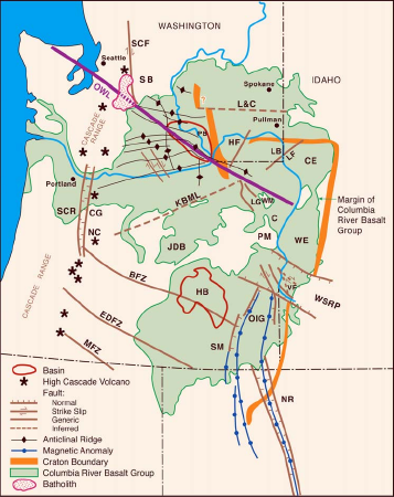
Cascade Range
The most notable geological feature crossing the OWL is the Cascade RangeCascade Range
The Cascade Range is a major mountain range of western North America, extending from southern British Columbia through Washington and Oregon to Northern California. It includes both non-volcanic mountains, such as the North Cascades, and the notable volcanoes known as the High Cascades...
, raised up in the Pliocene
Pliocene
The Pliocene Epoch is the period in the geologic timescale that extends from 5.332 million to 2.588 million years before present. It is the second and youngest epoch of the Neogene Period in the Cenozoic Era. The Pliocene follows the Miocene Epoch and is followed by the Pleistocene Epoch...
(two to five million years ago) as a result of the Cascadia subduction zone
Cascadia subduction zone
The Cascadia subduction zone is a subduction zone, a type of convergent plate boundary that stretches from northern Vancouver Island to northern California. It is a very long sloping fault that separates the Juan de Fuca and North America plates.New ocean floor is being created offshore of...
. These mountains are distinctly different on either side of the OWL, the material of the South Cascades being Cenozoic
Cenozoic
The Cenozoic era is the current and most recent of the three Phanerozoic geological eras and covers the period from 65.5 mya to the present. The era began in the wake of the Cretaceous–Tertiary extinction event at the end of the Cretaceous that saw the demise of the last non-avian dinosaurs and...
(<66 Ma) volcanic and sedimentary rock, and the North Cascades being much older Paleozoic
Paleozoic
The Paleozoic era is the earliest of three geologic eras of the Phanerozoic eon, spanning from roughly...
(hundreds of millions of years) metamorphic and plutonic rocks. It is unknown whether this difference is in any way linked with the OWL, or is simply a coincidental regional difference.
Raisz judged the Cascades on the north side of the OWL to be offset about six miles to the west, and similarly for the Blue Mountains, but this is questionable, and similar offsets are not apparent in the older – up to 17 Ma (millions of years) old – Columbia River basalt flows
Columbia River Basalt Group
The Columbia River Basalt Group is a large igneous province that lies across parts of the Western United States. It is found in the U.S. states of Washington, Oregon, Idaho, Nevada, and California...
. In general, there are no clear indications of structures offset by the OWL, but neither are there any distinct features crossing the OWL (and older than 17 Ma) that positively demonstrate a lack of offsetting.
Straight Creek Fault
The Straight Creek FaultStraight Creek Fault
The Straight Creek Fault is the principal north-south strike-slip fault in the state of Washington, with a minimum of 90 kilometers of right-lateral offset, and a major geological structure in the North Cascade mountains, where it separates the pre-Tertiary igneous and metamorphic rocks of the...
(SCF) – just east of Snoqualmie Pass and running nearly due north into Canada – is a major fault notable for considerable identified dextral strike-slip offset (opposite side moving laterally to the right) of at least 90 km (55.9 mi). Its intersection with the OWL (near Kachess Lake
Kachess Lake
Kachess Lake is a lake and reservoir along the course of the Kachess River in Washington state, USA. The upper part of the lake, north of a narrows, is called Little Kachess Lake. The Kachess River flows into the lake from the north, and out from the south...
) is the geological equivalent of an atom smasher, and the results should be informative. For example, that the OWL is not offset suggests that it must be younger than the last strike-slip motion on the SCF, anywhere from around 44 to about 41 million years ago (i.e., during the middle-Eocene
Eocene
The Eocene Epoch, lasting from about 56 to 34 million years ago , is a major division of the geologic timescale and the second epoch of the Paleogene Period in the Cenozoic Era. The Eocene spans the time from the end of the Palaeocene Epoch to the beginning of the Oligocene Epoch. The start of the...
epoch). And if the OWL is a strike-slip fault or megashear, as many have speculated, then it should offset the SCF, and whether the OWL offsets the SCF, or not, becomes an important test of just what the OWL is.
So does the OWL offset the SCF, or not? It is hard to say, as no trace whatsoever has been found of the SCF anywhere south of the OWL. While some geologists have speculated that it does continue directly south, albeit hidden under younger deposits, not a trace has been found.
If the SCF fault does not continue directly southward – and the utter lack of evidence that it does makes a case for evidence of lack – then where else might it be? suggest some possibilities: it may curve to the east, it may curve to the west, or it may just end.
Tabor mapped the SCF turning and merging with the Taneum fault (coincident with the OWL) south of Kachess Lake. This conforms with the general pattern seen in Lakes Keechelus, Kachess, and Cle Elum, and associated geological units and faults (see image, right): each is aligned north—south at the north end, but turns to the southeast where it approaches the OWL. This is suggestive of the OWL being a left lateral (sinistral) strike-slip fault that has distorted and offset the SCF. But that is inconsistent with the SCF itself and most other strike-slip faults associated with the OWL being right lateral (dextral), and incompatible with the geology to the southeast. Particularly, studies of the region to the southeast (in connection with Department of Energy activities at the Hanford Reservation) show no indication of any fault or other structure comparable to the SCF.
On the other hand, maps the SCF as proceeding southerly (without addressing the situation south of the OWL). (He has subsequently speculated that the missing part of the SCF may have been dextrally offset to become a southerly trending fault in the Puget Lowland. But same problem: later deposits cover any traces.) The seeming southeasterly curvature is possibly explained as a geometrical effect of foreshortening: it occurs in a belt of intense folding (much resembling a rug which has slid against a wall) which, if unfolded, could restore some of the "curves" to a linear position along the southerly extension of the SCF.
There seem to be no indications that the SCF turns to the west. Although such indications would mostly be buried, the general sense of the topography suggests no such turn. Displacement, to either the west or the east, seems unlikely in that certain effects that would be expected are not found.
Could the SCF just end? This is difficult to comprehend. If there is displacement along this fault, where did it come from? To quote Wyld et al. (albeit in the context of a different fault): "it cannot just end". Although the SCF has had substantial strike-slip displacement, claim that final major movement on the SCF (about 40 Ma ago) was dominantly dip-slip (vertical displacement). So perhaps the displacement came from the depths, and, as it was extruded, was eroded and redistributed as sediments. But this has not been established.
Another possibility is that the missing southern segment of the SCF is on a crustal block that rotated away from the OWL. There is evidence that around 45 million years ago much of Oregon and southwestern
Washington rotated some 60° or more about a pivot somewhere in the Olympic Peninsula (see Oregon rotation, below). This would have left a large gap south of the OWL, which could explain why Tertiary rocks are not found immediately south of the OWL. This suggests that a continuation of the SCF, if any, and the missing Tertiary rock, might be somewhere southwest of Mount Saint Helens, but this has not been observed.
Darrington–Devils Mountain Fault Zone
The interaction of the Straight Creek Fault with the OWL has yielded practically no intelligible information, and remains as enigmatic as the OWL itself. More informative is the closely related Darrington—Devils Mountain Fault Zone (DDMFZ). It runs east from a complex of faults on the southern end of Vancouver IslandVancouver Island
Vancouver Island is a large island in British Columbia, Canada. It is one of several North American locations named after George Vancouver, the British Royal Navy officer who explored the Pacific Northwest coast of North America between 1791 and 1794...
to the town of Darrington, where it turns south to converge with the SCF (see map, above).
North of the DDMFZ (and west of the SCF) is the Chuckanut Formation
Chuckanut Formation
The Chuckanut Formation in northwestern Washington , its extension in southwestern British Columbia , and various related formations in central Washington are fluvial sedimentary formations of Eocene age, deposited from about 54 Ma The Chuckanut Formation in northwestern Washington (named after...
(part of the "Northwest Cascade System" of rocks shown in green on the map), an Eocene
Eocene
The Eocene Epoch, lasting from about 56 to 34 million years ago , is a major division of the geologic timescale and the second epoch of the Paleogene Period in the Cenozoic Era. The Eocene spans the time from the end of the Palaeocene Epoch to the beginning of the Oligocene Epoch. The start of the...
sedimentary formation which formed adjacent to the Swauk, Roslyn and other formations (also in green) south of Mount Stuart
Mount Stuart
Mount Stuart is a mountain in the Cascade Range, in the U.S. state of Washington. It is the second highest non-volcanic peak in the state, after Bonanza Peak and tenth-highest overall...
; their wide separation is attributed to right-lateral strike-slip movement along the SCF. That the northern part of the DDMFZ shows left-lateral strike-slip movement is not the inconsistency it may initially seem – think of the motion on either side of an arrowhead.
It appears that what is now the DDMFZ was originally aligned on the OWL. Then about 50 Ma ago North America crashed into what is now the Olympic Peninsula along an axis nearly perpendicular to the OWL, pushing the rock of the Mesozoic (pre-Tertiary) Western and Eastern Melange Belts (WEMB, blue on the map) across the OWL, bowing the DDMFZ, and initiating the SCF and thereby splitting the Chuckanut Formation. On the north side of the DDMFZ, and wrapping around a bit to the east side, is a suite of distinctive rocks – the Helena—Haystack mélange ("HH Melange" on the map) – which was collapsed into vertical folds. Similarly distinctive rock is found in Manastash Ridge
Manastash Ridge
Manastash Ridge is a long anticline mountain ridge located in central Washington state in the United States. Manastash Ridge runs mostly west-to-east in Kittitas and Yakima counties, for approximately 50 miles...
(shown on the map, but almost too small to see) still lying on the OWL, just east of the SCF.
This can explain an early puzzle as to why the Mesozic rocks just south of the DDMFZ – the Western and Eastern Melange Belts – have no counterpart on the east side of the OWL and offset to the south: they were not faulted by the SCF, but were pushed against it from the southwest.
Then it gets curiouser. Rock very similar to the WEMB (including a type called blueschist
Blueschist
Blueschist is a rock that forms by the metamorphism of basalt and rocks with similar composition at high pressures and low temperatures, approximately corresponding to a depth of 15 to 30 kilometers and 200 to ~500 degrees Celsius....
) is also found in the San Juan Islands, and along the West Coast fault on the west side of Vancouver Island. This suggests that the OWL was once a strike-slip fault, possibly a continental margin, along which terranes moved from the southeast. But similar rock also occurs in the Rimrock Lake Inlier, about 75 km south of the OWL and just west of the projected trace of the SCF, and also in the Klamath Mountains of southwestern Oregon. To account for the wide dispersal of this rock is difficult; many geologists see no alternative to transport along an extended SCF. But that upsets some of the "solutions" described above, and there is yet no consensus on this.
CLEW and Columbia Plateau
Further east is the "CLEW", the segment of the OWL from approximately the town of Cle Elum (marking the western limit of the Columbia River basalts) to the Wallula GapWallula Gap
Wallula Gap is a large water gap of the Columbia River through basalt anticlines in the Columbia River Basin in the U.S. state of Washington, just south of the confluence of the Walla Walla and Columbia rivers...
(a narrow gap on the Columbia River just north of the Oregon border). This segment, and the associated Yakima fold belts, do include many northeast-trending faults crossing the
OWL. However, these are largely dip-slip (vertical) faults, associated with compressional folding of the overlying basalt. As there is typically 3 km of sedimentary deposits separating the basalts
(also about 3 km thick) from the basement rock, these faults are somewhat isolated from the deeper structure. The geological consensus is that any strike-slip activity on the OWL predates the 17 Ma old Columbia River Basalt Group
Columbia River Basalt Group
The Columbia River Basalt Group is a large igneous province that lies across parts of the Western United States. It is found in the U.S. states of Washington, Oregon, Idaho, Nevada, and California...
.
There is some evidence that some of the northwest-trending ridges may have some continuity with the basement structure, but the nature and details of the deeper structure is not known.
A 260 km long seismic refraction
Seismic refraction
Seismic refraction is a geophysical principle governed by Snell's Law. Used in the fields of engineering geology, geotechnical engineering and exploration geophysics, seismic refraction traverses are performed using a seismograph and/or geophone, in an array and an energy source...
profile
showed a rise in the crustal basement beneath the OWL, but was unable to determine if that rise was aligned with the OWL, or just coincidentally crossed the OWL at the same location as the profile; gravity data suggested the latter. The seismic data showed a uniformity of rock type and thickness across the OWL that discounts the possibility of it being a boundary between continental and oceanic crust. The results were interpreted as suggesting continental rifting during the Eocene, perhaps a failed rift basin, possibly connected with the rotation of the Klamath Mountain block away from the Idaho Batholith (see Oregon rotation, below).
There is a curious change of character of the OWL in the center of the CLEW where it crosses the roughly north-trending Hog Ranch—Naneum Anticline. West of there the OWL seems to follow a ridge in the basement structure, to the east it follows a gravity gradient, much like the Klamath–Blue Mountain LIneament (see below) does.
The significance of all this is not known.
Hite Fault System
Past the Wallula Gap the OWL is identified with the Wallula Fault Zone, which heads towards the Blue MountainsBlue Mountains (Oregon)
The Blue Mountains are a mountain range in the western United States, located largely in northeastern Oregon and stretching into southeastern Washington...
. The Wallula Fault Zone is active, but whether that can be attributed to the OWL is unknown: it may be that, like the Yakima Fold Belt, it is a result of regional stresses, and is expressed only in the superficial basalt, quite independently of what ever is happening in the basement rock.
At the western edge of the Blue Mountains the Wallula Fault zone intersects the northeast-striking Hite Fault System (HFS). This system is complex and has been variously interpreted.
Although seismically active it appears to be offset by, and thus should be older than, the Wallula fault.
On the other hand, a later study found "no obvious displacement" of either the OWL or HFS–related faults. Reidel et al. suggested that the HFS reflects the eastern margin of a piece of old continental craton (centered around the "HF" – Hite Fault – on the map) that has slipped south; Kuehn attributed 80 to 100 kilometers of left-lateral displacement along the HFS (and significant vertical displacements).
The interaction of the Wallula and Hite Fault systems is not yet understood. Past the Hite Fault System the OWL enters a region of geological complexity and confusion, where even the trace of the OWL is less clear, even to the point where it has been suggested that both the topographic feature and the Wallula fault are terminated by the Hite fault.
The original topographic lineament as described by Raisz is along the scarp on the northeast side of the Wallowa Mountains. However, there is a sense that the trend of the faulting in that area turns more to the south; it has been suggested the faulting associated with the OWL takes a large step south to the Vale Fault Zone, which connects with the Snake River Fault Zone in Idaho.
Both of these lines introduce a bend into the OWL. The Imnaha Fault (striking towards Riggins, Idaho
Riggins, Idaho
Riggins is a city in Idaho County, Idaho, United States. It is nestled deep in a canyon at the confluence of the Salmon River and the Little Salmon River in west central Idaho, approximately 150 highway miles north of Boise, and 120 highway miles south-southeast of Lewiston...
) is more nearly in line with the rest of the OWL, and in line with the previously mentioned gravitational anomalies that run into the continent.
Which ever way is deemed correct, it is notable that the OWL seems to change character after it crosses the Hite Fault System. What this says about the nature of the OWL is unclear, although Kuehn concluded that, in northeastern Oregon or western Idaho, it is not a tectonically significant structure.
Wallowa terrane
As described above, the trace of the OWL becomes faint and somewhat confused between the Blue Mountains and the margin of the North American cratonCraton
A craton is an old and stable part of the continental lithosphere. Having often survived cycles of merging and rifting of continents, cratons are generally found in the interiors of tectonic plates. They are characteristically composed of ancient crystalline basement rock, which may be covered by...
(the thick orange line on the map, just beyond the Oregon—Idaho border; the dashed line on the diagram below). This is the Wallowa terrane, a piece of crust that drifted in from somewhere else and got jammed between the Columbia Embayment to the west and the North American continent to the east and north. A notable feature is the anomalously elevated Wallowa Mountains
Wallowa Mountains
The Wallowa Mountains are a mountain range located in the Columbia Plateau of northeastern Oregon in the United States. The range runs approximately 40 mi northwest to southeast in southwestern Wallowa County between the Blue Mountains to the west and the Snake River to the east. The range is...
, to the east is Hells Canyon
Hells Canyon
Hells Canyon is a wide canyon located along the border of eastern Oregon and western Idaho in the United States. It is North America's deepest river gorge at and part of the Hells Canyon National Recreation Area....
(Snake River) on the Oregon—Idaho border. Northeast of the OWL (Wallowa Mountains) is the Clearwater Embayment ("CE" on the map), delineated by ancient rock of the craton. Southwest of this section of the OWL is a region of graben
Graben
In geology, a graben is a depressed block of land bordered by parallel faults. Graben is German for ditch. Graben is used for both the singular and plural....
s (where large blocks of crust have dropped) extending about 60 miles (96.6 km) south to the nearly parallel Vale Fault Zone (see diagram, below).
Graben
In geology, a graben is a depressed block of land bordered by parallel faults. Graben is German for ditch. Graben is used for both the singular and plural....
s form where the crust is being stretched or extended. Several explanations have been offered as to why this is happening here. theorized that right-lateral slip on the Wallula Fault is being transferred to more southerly faults such as the Vale Fault, wherefore he labelled this region the Wallula–Vale Transfer Zone. suggested that crustal deformation in this region is a continuation of the Basin and Range region immediately to the south, with any connection to the OWL deemed circumstantial. Another explanation is that clock-wise rotation of part of Oregon (discussed below) about a point near the Wallula Gap has pulled the Blue Mountains away from the OWL; this might also explain why the OWL seems to be bending here.
These theories may all have some truth to them, but what they might imply regarding the genesis and structure of the OWL has not been worked out.
Hells Canyon
Hells Canyon
Hells Canyon is a wide canyon located along the border of eastern Oregon and western Idaho in the United States. It is North America's deepest river gorge at and part of the Hells Canyon National Recreation Area....
– North America's deepest river gorge – is so deep because the terrain it cuts through is so high. This is generally attributed to thinning of the crust, which allows the hotter, and therefore lighter and more buoyant, mantle
Mantle (geology)
The mantle is a part of a terrestrial planet or other rocky body large enough to have differentiation by density. The interior of the Earth, similar to the other terrestrial planets, is chemically divided into layers. The mantle is a highly viscous layer between the crust and the outer core....
material to rise higher. This is believed by many to be involved with the Yellowstone hotspot
Yellowstone hotspot
The Yellowstone hotspot, also referred to as the Snake River Plain-Yellowstone hotspot, is a volcanic hotspot responsible for large scale volcanism in Oregon, Nevada, Idaho, and Wyoming, United States. It created the eastern Snake River Plain through a succession of caldera forming eruptions...
and Columbia River Basalts
Columbia River Basalt Group
The Columbia River Basalt Group is a large igneous province that lies across parts of the Western United States. It is found in the U.S. states of Washington, Oregon, Idaho, Nevada, and California...
; the nature of such involvement, if any, is hotly debated.
While the Yellowstone hotspot and Columbia River Basalts do not seem to directly interact with the OWL, clarification of their origin and context might explain some of the OWL's context, and even constrain possible models. Likewise, clarification of the nature and history of the Wallowa terrane, and particularly of the nature and causes of the apparent bending and multiple alignments of the OWL in this region, would be a major step in understanding the OWL.
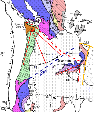
Columbia Embayment and KBML
The bedrock of Washington and Oregon, like most of the continent, is nearly all pre-Cenozoic (or pre-Tertiary) rock, older than 66 million years. The exception is southwestern Washington and Oregon, which has virtually no pre-Cenozoic strata. This is the Columbia Embayment, a large indentation into the North American continent characterized by oceanic crust covered by thick sedimentary deposits. ("Embayment" is perhaps a misleading term, in that it suggests a bowing of a coast line, which only seems so in the context of the modern coast. In the geological past, the coast of North America was in Idaho and Nevada, as will be described later.)The Columbia Embayment is of interest here because its northern margin is approximately delineated by the OWL. The variations are mainly in the region of the CLEW, where sediments are buried under the basalts of the Columbia Basin
Columbia Basin
The Columbia Basin, the drainage basin of the Columbia River, occupies a large area–about —of the Pacific Northwest region of North America. In common usage, the term often refers to a smaller area, generally the portion of the drainage basin that lies within eastern Washington.Usage of the term...
, and in Puget Sound, where the Cenozoic geology extends as far north as Vancouver Island. Whether the OWL might reflect a deeper crustal boundary has been
questioned by geophysical studies which may – or may not – see the characteristics expected of such a boundary.
The southern edge of the Columbia Embayment is along a line from the Klamath Mountains on the Oregon coast to a point in the Blue Mountains just east of the Wallula Gap. Unlike the OWL, this line has little topographical expression, and aside from the Hite Fault System is not associated with any major fault systems. But mapping of gravitational anomalies shows a definite lineament, some 700 km (about 400 miles) long, called the Klamath-Blue Mountain Lineament (KBML). This lineament is of interest here because of the possibility it was formerly conjugate with OWL, discussed in the next section.
Oregon rotation
Then the situation gets very interesting. Measurements of paleomagnetismPaleomagnetism
Paleomagnetism is the study of the record of the Earth's magnetic field in rocks. Certain minerals in rocks lock-in a record of the direction and intensity of the magnetic field when they form. This record provides information on the past behavior of Earth's magnetic field and the past location of...
(the record of the direction the rock was pointed when it cooled) from a variety of sites in the Coast Range – from the Klamath Mountains to the Olympic Peninsula – consistently measure clockwise rotations of 50 to 70 degrees. (See map, below.)
One interpretation of this is that western Oregon and southwestern Washington have swung as a rigid block about a pivot point at the northern end, near the Olympic Peninsula.
Eocene
The Eocene Epoch, lasting from about 56 to 34 million years ago , is a major division of the geologic timescale and the second epoch of the Paleogene Period in the Cenozoic Era. The Eocene spans the time from the end of the Palaeocene Epoch to the beginning of the Oligocene Epoch. The start of the...
). This interpretation implies a "back arc" of magmatism, probably fed by a subduction zone, and possibly implicated with the intrusion of various plutons in the North Cascades around 50 Ma. Curiously, this is just when the Kula–Farallon spreading ridge passed under the OWL (discussed below). found a spurt of rapid rotation around 45 Ma ago. This may be when this block was impinged by the Sierra Nevada block of California; note that around 40 Ma ago there was a change in the direction of the Pacific Plate (possibly due to collision with another plate). (The cause and nature of the rifting does not seem to have been worked out yet. Certain complications in the subduction of the Kula and Farallon plates may have been involved.)
During this rotation of the Coast Range the block of continental crust that is now the Blue Mountains (on the eastern side of the KBML) was also rifted away from the Idaho batholith, and also rotated about 50 degrees, but about a point near the Wallula Gap (or perhaps further east).
In the resulting gap the crust was stretched and thinned; the buoyancy of the hotter mantle have contributed to the subsequent rise of the Wallowa and Seven Devils Mountains, and perhaps also with the irruption of the Columbia River basalts
Columbia River Basalt Group
The Columbia River Basalt Group is a large igneous province that lies across parts of the Western United States. It is found in the U.S. states of Washington, Oregon, Idaho, Nevada, and California...
and other basalt flows.
While the rigid-block rotation model has much appeal, many geologists prefer another interpretation that minimizes whole–block rotation, and instead of rifting invokes "dextral shear" (resulting from the relative motion of the Pacific plate past the North American plate, or possibly from the extension of the Basin and Range province) as the primary driving force. The large values of paleomagnetic rotation are explained by a "ball bearing" model: the entire Oregon block (western Oregon including the Cascades and southwestern Washington) are deemed to be composed of many smaller blocks (on the scale of tens of kilometers), each of which rotates independently on its own axis.
Evidence of such small blocks (at least in southwestern Washington) has been claimed.
Later work has attempted to work out how much of the paleomagnetic rotation reflects actual block rotation;
although the amount of rotation has been reduced (to perhaps only 28°), it seems it will not entirely go away. How this affects the postulated rifting does not seem to have been addressed. A more recent work based on analysis of GPS measurements concluded that "most of the Pacific Northwest can be described by a few large, rotating, elastic crustal blocks", but noted that in a zone about 50 km wide on the Oregon coast the apparent rotation rate seems to double; this suggests that multiple models may be applicable.
Modern measurements show that the central Oregon is still rotating, with the calculated rotation poles bracketing the Wallula Gap., which is approximately the intersection of the OWL and KBML. It is intriguing to consider whether the KBML has participated in this rotation, but this is unclear; that it is unbent where it crosses the OWL suggests it is not. The OWL seems to be the northern edge of the rotating block, and the paucity of paleomagnetic data to the southeast of the KBML suggests it might be the southern edge. But the details of all this remain murky.
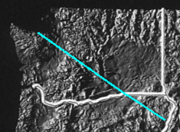
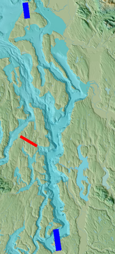
Puget Sound
Puget Sound
Puget Sound is a sound in the U.S. state of Washington. It is a complex estuarine system of interconnected marine waterways and basins, with one major and one minor connection to the Strait of Juan de Fuca and the Pacific Ocean — Admiralty Inlet being the major connection and...
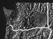
, and it is curious to consider the possible implications of a Puget Sound Fault. (Such a fault was once proposed on the basis of certain marine seismic data, but the proposal was stiffly rejected, and now seems to have been abandoned.) Combined terrestrial and bathymetric topography shows a distinct lineament along the west side of Puget Sound from Vashon Island (just north of Tacoma) north to the west side of Holmes Harbor and Saratoga Passage on Whidbey Island
Whidbey Island
Whidbey Island is one of nine islands located in Island County, Washington, in the United States. Whidbey is located about north of Seattle, and lies between the Olympic Peninsula and the I-5 corridor of western Washington...
(see image). But at Port Madison
Port Madison
Port Madison, sometimes called Port Madison Bay, is a deep water bay located on the west shore of Puget Sound in western Washington. It is bounded on the north by Indianola, on the west by Suquamish, and on the south by Bainbridge Island. Port Madison connects to Port Orchard via the Agate Pass...
(at the red bar in the image) it is split by a distinct offset of several miles.
Curiously, the southern section lies in the approximate zone of the OWL. (Note OWL–associated lineaments running parallel to the red line.) This suggests dextral offset along a strike-slip fault. But if that is the case then there should be a major fault in the vicinity of Port Madison and crossing to Seattle (perhaps at the Ship Canal, aligned with the red line) – but for this there is even less evidence then there was for the Puget Sound fault.
The significance of this lineament and its offset is entirely unknown. That it seems to be expressed in Ice Age (16 Ka) deposits implies a very recent but entirely unknown event; but perhaps these recent deposits are only draped over a much older topography. A recent offset might explain the apparent offsetting of north–south glacial drumlins bisected by the Ship Canal, but is not evident in more eastern segments.
Alternately – and this would seem very pertinent in regard of the OWL – perhaps some mechanism other than strike-slip faulting creates these lineaments.
Seattle Fault
A locally notable feature that crosses the zone of the OWL is the west-east Seattle FaultSeattle Fault
The Seattle Fault is a zone of multiple shallow east-west thrust faults that cross the Puget Sound Lowland and through Seattle in the vicinity of Interstate Highway 90...
. This is not a strike-slip fault, but a thrust fault
Thrust fault
A thrust fault is a type of fault, or break in the Earth's crust across which there has been relative movement, in which rocks of lower stratigraphic position are pushed up and over higher strata. They are often recognized because they place older rocks above younger...
, where a relatively shallow slab of rock from the south is being pushed against and over the northern part. (And over the OWL.) One model has the slab of rock being forced up by some structure about 8 km deep. Another model has the base of the slab (again, about 8 km deep) catching on something, which causes the leading edge to roll. The nature of the underlying structure is not known; geophysical data does not indicate a major fault nor any kind of crustal boundary along the front of the Seattle Fault, nor along the OWL, but this could be due to the limited reach of geophysical methods. Recent geological mapping at the eastern side of the Seattle Fault suggests a decollement
Decollement
Décollement is a gliding plane between two rock masses. In French, "décoller" means "to detach from" or "to rip off" and was first used by geologists studying the structure of the Swiss Jura Mountains, but is also known as a detachment zone. This is a structure of strata owing to deformation,...
(horizontal plane) about 18 km deep.
These models were developed in study of the western segment of the Seattle Fault. In the center segment, where it crosses surface exposures of Eocene rock associated with the OWL, the various strands of the fault – elsewhere fairly orderly – meander. The significance of this and the nature of the interaction with the Eocene rock are also not known.
Examination of the various strands of the Seattle Fault, particularly in the central section, is similarly suggestive of ripples in a flow that is obliquely crossing some deeper sill. This is an intriguing idea that could explain how local and seemingly independent features could be organized from depth, and even across a large scale, but it does not seem to have been considered. This is likely due, in part, to a paucity of information on the nature and structure of the lower crust where such a sill would exist.
Southern Whidbey Island Fault and RMFZ
The Southern Whidbey Island Fault (SWIF), running nearly parallel to the OWL from Victoria, B.C., southeast to the Cascade foothills to a point northeast of Seattle, is notable as the contact between the Coast Range block of oceanic crust to the west and the Cascades block of pre-Tertiary continental crust to the east.It appears to connect with the more southerly oriented right-lateral Rattlesnake Mountain Fault Zone (RMFZ) straddling Rattlesnake Mountain (near North Bend), which shows a similar deep-seated contact between different kinds of basement rock. At the southern end of Rattlesnake Mountain – exactly where the first lineament of the OWL is encountered – at least one strand of the RMFZ (the others are hidden) turns to run by Cedar Falls and up the Cedar River. Other faults to the south also show a similar turn, suggesting a general turning or bending across the OWL, yet such a bend is not apparent in the pattern of physiographic features that express the OWL. With awareness that the Seattle Fault and the RMFZ are the edges of a large sheet of material which is moving north, there is a distinct impression that these faults, and even some of the topographical features, are flowing around the corner of the Snoqualmie Valley. If it seems odd that a mountain should "float" around a valley: bear in mind that while the surface relief is about three-quarters of a kilometer (half a mile) in height, the material flowing could be as much as eighteen kilometers deep. (The analogy of icebergs moving around a submerged sandbar is quite apt.) It is worth noting that Cedar Butte – a minor prominence just east of Cedar Falls – is the southwestern-most exposure in the region of some very old Cretaceaous (pre-Tertiary) metamorphic rock. It seems quite plausible that there is some well-founded and obdurate obstruction at depth, around which the shallower and younger sedimentary formations are flowing. In such a context the observed arcuate fault bends would be very natural.
Broader context
It is generally assumed that the pattern of the OWL is a manifestation of some deeper physical structure or process (the "ur-OWL"), which might be elucidated by studying the effects it has on other structures. As has been shown, study of features that should interact with OWL has yielded very little: a tentative age range (between 45 and 17 million years), suggestions that the ur-OWL arises from deep in the crust, and evidence that the OWL is not (contrary to expectations) itself a boundary between oceanic and continental crust.The lack of results so far suggests that the broader context of the OWL should be considered. Following are some elements of that broader context, which may – or may not – relate in some way to the OWL.
Plate tectonics
The broadest and fullest context of the OWL is the global system of plate tectonicsPlate tectonics
Plate tectonics is a scientific theory that describes the large scale motions of Earth's lithosphere...
, driven by convective flows in the Earth's mantle. The primary story on the western margin of North America is the accretion, subduction, obduction, and translation of plates,
micro-plates, terranes, and crustal blocks between the converging Pacific and North American plates. (For an excellent geological history of Washington, including plate tectonics, see the Burke Museum web site.)
The principal tectonic plate in this region (Washington, Oregon, Idaho) is the North American plate
North American Plate
The North American Plate is a tectonic plate covering most of North America, Greenland, Cuba, Bahamas, and parts of Siberia, Japan and Iceland. It extends eastward to the Mid-Atlantic Ridge and westward to the Chersky Range in eastern Siberia. The plate includes both continental and oceanic crust...
, consisting of a craton
Craton
A craton is an old and stable part of the continental lithosphere. Having often survived cycles of merging and rifting of continents, cratons are generally found in the interiors of tectonic plates. They are characteristically composed of ancient crystalline basement rock, which may be covered by...
of ancient, relatively stable continental crust
Continental crust
The continental crust is the layer of igneous, sedimentary, and metamorphic rocks which form the continents and the areas of shallow seabed close to their shores, known as continental shelves. This layer is sometimes called sial due to more felsic, or granitic, bulk composition, which lies in...
and various additional parts that have been accreted; this is essentially the whole of the North American continent. The interaction of the North American plate with various other plates, terranes, etc., along its western margin is the primary engine of geology in this region.
Since the breakup of the Pangaea
Pangaea
Pangaea, Pangæa, or Pangea is hypothesized as a supercontinent that existed during the Paleozoic and Mesozoic eras about 250 million years ago, before the component continents were separated into their current configuration....
supercontinent in the Jurassic
Jurassic
The Jurassic is a geologic period and system that extends from about Mya to Mya, that is, from the end of the Triassic to the beginning of the Cretaceous. The Jurassic constitutes the middle period of the Mesozoic era, also known as the age of reptiles. The start of the period is marked by...
(about 250 million years ago) the main tectonic story here has been the North American Plate's subduction of the Farallon Plate
Farallon Plate
The Farallon Plate was an ancient oceanic plate, which began subducting under the west coast of the North American Plate— then located in modern Utah— as Pangaea broke apart during the Jurassic Period...
(see below) and its remaining fragments (such as the Kula
Kula Plate
The Kula Plate is an oceanic tectonic plate under the northern Pacific Ocean south of the Near Islands segment of the Aleutian Islands. It is subducting under the North American Plate at the Aleutian Trench and is surrounded by the Pacific Plate...
, Juan de Fuca
Juan de Fuca Plate
The Juan de Fuca Plate, named after the explorer of the same name, is a tectonic plate, generated from the Juan de Fuca Ridge, and subducting under the northerly portion of the western side of the North American Plate at the Cascadia subduction zone...
, Gorda
Gorda Plate
The Gorda Plate, located beneath the Pacific Ocean off the coast of northern California, is one of the northern remnants of the Farallon Plate. It is sometimes referred to as simply the southernmost portion of the neighboring Juan de Fuca Plate, another Farallon remnant.Unlike most tectonic...
, and Explorer
Explorer Plate
The Explorer Plate is an oceanic tectonic plate beneath the Pacific Ocean off the west coast of Vancouver Island, Canada.The eastern boundary of the Explorer Plate is being slowly subducted under the North American Plate, to which it may eventually accrete owing to the slow rate of subduction...
plates). As the North American plate overrides the last of each remnant it comes into contact with the Pacific Plate, generally forming a transform fault
Transform fault
A transform fault or transform boundary, also known as conservative plate boundary since these faults neither create nor destroy lithosphere, is a type of fault whose relative motion is predominantly horizontal in either sinistral or dextral direction. Furthermore, transform faults end abruptly...
, such as the Queen Charlotte Fault
Queen Charlotte Fault
The Queen Charlotte Fault is an active transform fault, located between the North American Plate and the Pacific Plate, Canada's equivalent of the San Andreas Fault. The Queen Charlotte Fault forms a triple junction on its south with the Cascadia subduction zone and the Explorer Ridge...
running north of Vancouver Island
Vancouver Island
Vancouver Island is a large island in British Columbia, Canada. It is one of several North American locations named after George Vancouver, the British Royal Navy officer who explored the Pacific Northwest coast of North America between 1791 and 1794...
, and the San Andreas Fault
San Andreas Fault
The San Andreas Fault is a continental strike-slip fault that runs a length of roughly through California in the United States. The fault's motion is right-lateral strike-slip...
on the coast of California. Between these is the Cascadia subduction zone
Cascadia subduction zone
The Cascadia subduction zone is a subduction zone, a type of convergent plate boundary that stretches from northern Vancouver Island to northern California. It is a very long sloping fault that separates the Juan de Fuca and North America plates.New ocean floor is being created offshore of...
, the last portion of a subduction zone that once stretched from Central America to Alaska.
This has not been a steady process. 50 Ma (million years) ago there was a change in the direction of motion of the Pacific plate (as recorded in the bend in the Hawaiian-Emperor seamount chain
Hawaiian-Emperor seamount chain
The Hawaiian–Emperor seamount chain is composed of the Hawaiian ridge, consisting of the islands of the Hawaiian chain northwest to Kure Atoll, and the Emperor Seamounts, a vast underwater mountain region of islands and intervening seamounts, atolls, shallows, banks and reefs along a line trending...
). This had repercussions on all the adjoining plates, and may have had something to do with initiation of the Straight Creek Fault, and the end of the Laramide orogeny
Laramide orogeny
The Laramide orogeny was a period of mountain building in western North America, which started in the Late Cretaceous, 70 to 80 million years ago, and ended 35 to 55 million years ago. The exact duration and ages of beginning and end of the orogeny are in dispute, as is the cause. The Laramide...
(the uplift of the Rocky Mountains
Geology of the Rocky Mountains
The geology of the Rocky Mountains is that of a discontinuous series of mountain ranges with distinct geological origins. Collectively these make up the Rocky Mountains, a mountain system that stretches from Canada through central New Mexico and which is part of the great mountain system known as...
). This event may have set the stage for the OWL, as much of the crust in which it is expressed was formed around that epoch (the early Eocene
Eocene
The Eocene Epoch, lasting from about 56 to 34 million years ago , is a major division of the geologic timescale and the second epoch of the Paleogene Period in the Cenozoic Era. The Eocene spans the time from the end of the Palaeocene Epoch to the beginning of the Oligocene Epoch. The start of the...
); this may be when the story of the OWL starts. Other evidence suggests a similar plate reorganization around 80 Ma, possibly connected with the start of the Laramide orogeny. claimed at least five "major chaotic tectonic events since the Triassic". Each of these events is a possible candidate for creating some condition or structure that affected the OWL or ur-OWL, but knowledge of what these events were or their effects is itself still chaotic.
Complicating the geology is a stream of terranes – crustal blocks – that have been streaming north along the continental margin for over 120 Ma (and probably much, much earlier), what has recently been called the North Pacific Rim orgenic Stream (NPRS). However, these terranes may be incidental to the OWL, as there are suggestions that local tectonic structures may be substantially affected by deeper and much older (e.g., Precambrian
Precambrian
The Precambrian is the name which describes the large span of time in Earth's history before the current Phanerozoic Eon, and is a Supereon divided into several eons of the geologic time scale...
) basement rock, and even lithospheric mantle structures.
Subduction of the Farallon and Kula Plates
Roughly 205 million years ago (during the JurassicJurassic
The Jurassic is a geologic period and system that extends from about Mya to Mya, that is, from the end of the Triassic to the beginning of the Cretaceous. The Jurassic constitutes the middle period of the Mesozoic era, also known as the age of reptiles. The start of the period is marked by...
period) the Pangaea
Pangaea
Pangaea, Pangæa, or Pangea is hypothesized as a supercontinent that existed during the Paleozoic and Mesozoic eras about 250 million years ago, before the component continents were separated into their current configuration....
supercontinent began to break up as a rift
Rift
In geology, a rift or chasm is a place where the Earth's crust and lithosphere are being pulled apart and is an example of extensional tectonics....
separated the North American Plate
North American Plate
The North American Plate is a tectonic plate covering most of North America, Greenland, Cuba, Bahamas, and parts of Siberia, Japan and Iceland. It extends eastward to the Mid-Atlantic Ridge and westward to the Chersky Range in eastern Siberia. The plate includes both continental and oceanic crust...
from what is now Europe, and pushed it west against the Farallon Plate
Farallon Plate
The Farallon Plate was an ancient oceanic plate, which began subducting under the west coast of the North American Plate— then located in modern Utah— as Pangaea broke apart during the Jurassic Period...
. During the subsequent Cretaceous Period (144 to 66 Ma ago) the entire Pacific coast of North America, from Alaska to Central America, was a subduction zone. The Farallon plate is notable for having been very large, and for subducting nearly horizontally under much of the United States and Mexico; it is likely connected with the Laramide Orogeny
Laramide orogeny
The Laramide orogeny was a period of mountain building in western North America, which started in the Late Cretaceous, 70 to 80 million years ago, and ended 35 to 55 million years ago. The exact duration and ages of beginning and end of the orogeny are in dispute, as is the cause. The Laramide...
. About 85 Ma ago the part of the Farallon plate from approximately California to the Gulf of Alaska separated to form the Kula Plate
Kula Plate
The Kula Plate is an oceanic tectonic plate under the northern Pacific Ocean south of the Near Islands segment of the Aleutian Islands. It is subducting under the North American Plate at the Aleutian Trench and is surrounded by the Pacific Plate...
.
The period 48–50 Ma (mid-Eocene) is especially interesting as this is when the subducted Kula—Farallon spreading ridge passed below what is now the OWL. (The Burke Museum has some nice diagrams of this.) This also marks the onset of the Oregon rotation, possibly with rifting along the OWL, and the initiation of the Queen Charlotte and Straight Creek Faults. The timing seems significant, but how all of these might be connected is unknown.
Around 30 Ma ago part of the spreading center between the Farallon Plate and Pacific Plate
Pacific Plate
The Pacific Plate is an oceanic tectonic plate that lies beneath the Pacific Ocean. At 103 million square kilometres, it is the largest tectonic plate....
was subducted under California, putting the Pacific plate into direct contact with the North American plate and creating the San Andreas Fault
San Andreas Fault
The San Andreas Fault is a continental strike-slip fault that runs a length of roughly through California in the United States. The fault's motion is right-lateral strike-slip...
. The remainder of the Farallon Plate split, with the part to the north becoming the Juan de Fuca Plate
Juan de Fuca Plate
The Juan de Fuca Plate, named after the explorer of the same name, is a tectonic plate, generated from the Juan de Fuca Ridge, and subducting under the northerly portion of the western side of the North American Plate at the Cascadia subduction zone...
; parts of this subsequently broke off to form the Gorda Plate
Gorda Plate
The Gorda Plate, located beneath the Pacific Ocean off the coast of northern California, is one of the northern remnants of the Farallon Plate. It is sometimes referred to as simply the southernmost portion of the neighboring Juan de Fuca Plate, another Farallon remnant.Unlike most tectonic...
and Explorer Plate
Explorer Plate
The Explorer Plate is an oceanic tectonic plate beneath the Pacific Ocean off the west coast of Vancouver Island, Canada.The eastern boundary of the Explorer Plate is being slowly subducted under the North American Plate, to which it may eventually accrete owing to the slow rate of subduction...
. By this time the last of the Kula Plate
Kula Plate
The Kula Plate is an oceanic tectonic plate under the northern Pacific Ocean south of the Near Islands segment of the Aleutian Islands. It is subducting under the North American Plate at the Aleutian Trench and is surrounded by the Pacific Plate...
had been subducted, initiating the Queen Charlotte
Queen Charlotte Fault
The Queen Charlotte Fault is an active transform fault, located between the North American Plate and the Pacific Plate, Canada's equivalent of the San Andreas Fault. The Queen Charlotte Fault forms a triple junction on its south with the Cascadia subduction zone and the Explorer Ridge...
transform fault on the coast of British Columbia; coastal subduction has been reduced to just the Cascadia Subduction Zone
Cascadia subduction zone
The Cascadia subduction zone is a subduction zone, a type of convergent plate boundary that stretches from northern Vancouver Island to northern California. It is a very long sloping fault that separates the Juan de Fuca and North America plates.New ocean floor is being created offshore of...
under Oregon and Washington.
Newberry Hotspot Track – Brothers Fault Zone
The Newberry Hotspot Track – a series of volcanic domes and lava flows closely coincident with the Brothers Fault ZoneBrothers Fault Zone
The Brothers Fault Zone — believed to have been named after Brothers, Oregon — is the most notable of a set of northwest trending fault zones including the Eugene—Denio, McLouglin, and Vale zones that dominate the geological structure of most of Oregon...
(BFZ) – is of interest because it is parallel to the OWL. Unlike anything on the OWL, these lava flows can be dated, and they show a westward age progression from an origin at the McDermitt Caldera on the Oregon-Nevada border to the Newberry Volcano
Newberry Volcano
Newberry Volcano is a large potentially active shield volcano located east of the Cascade Range and about southeast of Bend, Oregon. It is not a typical shield volcano. In addition to erupting basaltic lavas, it also has erupted andesitic and even rhyolitic lava.The volcano is in diameter and...
. Curiously, the Yellowstone hotspot
Yellowstone hotspot
The Yellowstone hotspot, also referred to as the Snake River Plain-Yellowstone hotspot, is a volcanic hotspot responsible for large scale volcanism in Oregon, Nevada, Idaho, and Wyoming, United States. It created the eastern Snake River Plain through a succession of caldera forming eruptions...
also appears to have originated in the vicinity of the McDermitt Caldera, and is generally considered to be closely associated with the Newberry magmatism.
But while the track of the Yellowstone hotspot across the Snake River Plain conforms to what is expected from the motion of the North American Plate
North American Plate
The North American Plate is a tectonic plate covering most of North America, Greenland, Cuba, Bahamas, and parts of Siberia, Japan and Iceland. It extends eastward to the Mid-Atlantic Ridge and westward to the Chersky Range in eastern Siberia. The plate includes both continental and oceanic crust...
across some sort of "hotspot" fixed in the underlying mantle, the Newberry "hotspot" track is oblique to the motion of the North American Plate; this is inconsistent with the hotspot model
Hotspot (geology)
The places known as hotspots or hot spots in geology are volcanic regions thought to be fed by underlying mantle that is anomalously hot compared with the mantle elsewhere. They may be on, near to, or far from tectonic plate boundaries. There are two hypotheses to explain them...
.
Alternative models include: 1) flow of material from the top layer of the mantle (asthenosphere) around the edge of the Juan de Fuca Plate (a.k.a. "Vancouver slab", 2) flows reflecting lithospheric topography (such as the edge of the craton), 3) faulting in the lithosphere
Lithosphere
The lithosphere is the rigid outermost shell of a rocky planet. On Earth, it comprises the crust and the portion of the upper mantle that behaves elastically on time scales of thousands of years or greater.- Earth's lithosphere :...
, or 4) extension of the Basin and Range province (which in turn may be due to interactions between the North American, Pacific, and Farallon Plates, and possibly with the subduction of the triple point
Triple point
In thermodynamics, the triple point of a substance is the temperature and pressure at which the three phases of that substance coexist in thermodynamic equilibrium...
where the three plates came together), but none is yet fully accepted.
These models generally attempt to account only for the source of the Newberry magmatism, attributing the "track" to pre-existing weakness in the crust. No model yet accounts for the particular orientation of the BFZ, or the parallel Eugene-Denio or Mendocino Fault Zones (see map).
Bermuda Hotspot Track?
It was noted as early as 1963 that the OWL seems to align with the Kodiak-Bowie Seamount chainKodiak-Bowie Seamount chain
The Kodiak–Bowie Seamount chain, also called the Pratt–Welker Seamount chain, is a seamount chain in southeastern Gulf of Alaska stretching from the Aleutian Trench in the north to Bowie Seamount, the youngest volcano in the chain, which lies west of the Queen Charlotte Islands,...
. A 1983 paper by Morgan suggested that this seamount—OWL alignment marks the passage some 150 Ma ago of the Bermuda hotspot
Bermuda hotspot
The Bermuda hotspot is the supposed "hotspot" proposed to explain the Bermuda Rise , and also...
. (This same passage has also been invoked to explain the Mississippi Embayment
Mississippi embayment
The Mississippi Embayment is a physiographic feature in the south-central United States, part of the Mississippi Alluvial Plain. It is essentially a northward continuation of the fluvial sediments of the Mississippi River Delta to its confluence with the Ohio River at Cairo, Illinois. The embayment...
.) However, substantial doubt has been raised as to whether Bermuda is truly a "hotspot", and lacking any supporting evidence this putative hotspot track is entirely speculative.
The 1983 paper also suggested that passage of a hot spot weakens the continental crust, leaving it vulnerable to rifting. But might the relation might actually run the other way: do some of these "hotspots" accumulate in zones where the crust is already weakened (by means as yet unknown)? The supposed Newberry hotspot track may exemplify this (see Megashears, below), but application of this concept more generally is not yet accepted. Application to the OWL would require resolving some other questions, such as how traces of a ca. 150 Ma event resisted being swept north into Alaska to influence a structure believed to be no older than 41 Ma (see Straight Creek Fault). Possibly there is some explanation, but geology has not yet found it.
Orofino Shear Zone
The OWL gets faint, perhaps even terminates, just east of the Oregon—Idaho border where it hits the north-trending Western Idaho Shear Zone (WISZ), a nearly vertical tectonic boundary between the accreted oceanic terranes to the west and the plutonic and metamorphic rock of the North American cratonCraton
A craton is an old and stable part of the continental lithosphere. Having often survived cycles of merging and rifting of continents, cratons are generally found in the interiors of tectonic plates. They are characteristically composed of ancient crystalline basement rock, which may be covered by...
(the ancient continental core) to the east. From the Mesozoic
Mesozoic
The Mesozoic era is an interval of geological time from about 250 million years ago to about 65 million years ago. It is often referred to as the age of reptiles because reptiles, namely dinosaurs, were the dominant terrestrial and marine vertebrates of the time...
till about 90 Ma (mid-Cretaceous
Cretaceous
The Cretaceous , derived from the Latin "creta" , usually abbreviated K for its German translation Kreide , is a geologic period and system from circa to million years ago. In the geologic timescale, the Cretaceous follows the Jurassic period and is followed by the Paleogene period of the...
) this was the western margin of the North American continent, into which various off-shore terranes were crashing into and then sliding to the north.
Near the town of Orofino (just east of Lewiston, Idaho) something curious happens: the craton margin makes a sharp right-angle bend to the west. What actually happens is the truncation of the WISZ by the WNW-trending Orofino Shear Zone (OSZ), which can be traced west roughly parallel with the OWL until it disappears below the Columbia River Basalts, and southeast across Idaho and possibly beyond. The truncation occurred between 90 to 70 Ma ago, possibly due to the docking of the Insular super-terrane
Insular Belt
The Insular Belt is a physiogeological region on the north western North American coast. It consist of three major island groups and many smaller islands and stretches from southern British Columbia into Alaska and the Yukon...
(now the coast of British Columbia). This was a major left-lateral transform fault, with the northern continuation of the WISZ believed to be one of the faults in the North Cascades. A similar offset is seen between the Canadian Rocky Mountains in British Columbia and the American Rocky Mountains in southern Idaho and western Wyoming.
Then another curious thing happens: before the west-trending craton margin turns north, it seems to loop south towards Walla Walla (near the Oregon border) and the Wallula Gap (see orange-line here, or dashed-line here). (Although southeastern Washington is pretty thoroughly covered by the Columbia River Basalts, a borehole in this loop recovered rock characteristic of the craton.) It seems that the OSZ may have been offset, perhaps by the Hite Fault, but, contrary to the regional trend, headed south. If this is a cross-cutting offset it would have to be younger than the OFZ (less than 70 Ma), and older than the OWL, which it does not offset. That the OWL and the OFZ are parallel (along with many other structures) suggests something in common, perhaps a connection at a deeper level. But this offsetting relationship indicates that they were created separately.
Megashears
The OFZ (also called the Trans-Idaho Discontinuity) is a local segment of a larger structure that has only recently been recognized, the Great Divide Megashear. East of the WISZ this turns to the southeast (much as the OWL may be doing past the Wallula Gap) to follow the Clearwater fault zone down the continental divide near the Idaho—Montana border to the northwestern corner of Wyoming. From there it seems to connect with the Snake River—Wichita fault zone, which passes through Colorado, and Oklahoma., and possibly further.There is a significant age discrepancy here. Whereas the OFZ is a mere 90 to 70 Ma old, this megashear is ancient, having been dated to the Mesoproterozoic
Mesoproterozoic
The Mesoproterozoic Era is a geologic era that occurred between 1600 Ma and 1000 Ma . The Mesoproterozoic was the first period of Earth's history with a respectable geological record. Continents existed in the Paleoproterozoic, but we know little about them...
– about a billion years ago. The Snake River—Wichita fault zone is of a similar age. What appears to be happening is exploitation of ancient weaknesses in the crust. This could explain the Newberry "hotspot track": parallel weaknesses in the crust open as the Brothers, Eugene—Denio, and Mendocino Fault Zones in response to development of the Basin and Range Province; magma from the event that initiated the Yellowstone hotspot (and possibly the Columbia River and other basalt flows) simply exploits the faults of the Brothers Fault Zone. The other faults do not develop as "hotspot tracks" simply because there is no magma source nearby. Similarly, it may be that the OWL reflects a similar zone of weakness, but does not develop as a major fault zone because it is too far from the stresses of the Basin and Range Province.
This could also explain why the OWL seems possibly aligned with the Kodiak-Bowie Seamount chain
Kodiak-Bowie Seamount chain
The Kodiak–Bowie Seamount chain, also called the Pratt–Welker Seamount chain, is a seamount chain in southeastern Gulf of Alaska stretching from the Aleutian Trench in the north to Bowie Seamount, the youngest volcano in the chain, which lies west of the Queen Charlotte Islands,...
in the Gulf of Alaska, especially as the apparent motion is the wrong direction for the OWL to be a mark of their past passage. They are also on the other side of the spreading centers, though that does suggest a pure speculation that these postulated zones of weakness could be related to transform faults from the spreading center.
Precambrian basement
Following the Great Divide Megashear into the mid-continent reveals something interesting: a widespread pattern of similarly trending (roughly NW-SE) fault zones, rifts, and aeromagnetic and gravitational anomalies. Although some of the faults are recent, the NW trending zones themselves have been attributed to continental-scale transcurrent shearing at about 1.5 Ga – that's billions of years ago – during the assembly of LaurentiaLaurentia
Laurentia is a large area of continental craton, which forms the ancient geological core of the North American continent...
(the North American continent).
Curiously, there is another widespread pattern of parallel fault zones, etc., of various ages trending roughly NE-SW, including the Midcontinent Rift System
Midcontinent Rift System
The Midcontinent Rift System or Keweenawan Rift is a long geological rift in the center of the North American continent and south-central part of the North American plate. It formed when the continent's core, the North American craton, began to split apart during the Mesoproterozoic era of the...
, the Reelfoot Rift (in the New Madrid Seismic Zone
New Madrid Seismic Zone
The New Madrid Seismic Zone , sometimes called the New Madrid Fault Line, is a major seismic zone and a prolific source of intraplate earthquakes in the southern and midwestern United States, stretching to the southwest from New Madrid, Missouri.The New Madrid fault system was responsible for the...
), and others. These fault zones and rifts occur on tectonic boundaries that date to the Proterozoic
Proterozoic
The Proterozoic is a geological eon representing a period before the first abundant complex life on Earth. The name Proterozoic comes from the Greek "earlier life"...
– that is, 1.8 to 1.6 billions of years old. They are also roughly parallel to the Ouachita
Ouachita orogeny
The Ouachita orogeny was a mountain building event that resulted in the folding and faulting of strata currently exposed in the Ouachita Mountains...
— Appalachian mountains
Alleghenian orogeny
The Alleghenian orogeny or Appalachian orogeny is one of the geological mountain-forming events that formed the Appalachian Mountains and Allegheny Mountains. The term and spelling Alleghany orogeny was originally proposed by H.P. Woodward in 1957....
, raised when Laurentia
Laurentia
Laurentia is a large area of continental craton, which forms the ancient geological core of the North American continent...
merged with the other continents to form the Pangaea
Pangaea
Pangaea, Pangæa, or Pangea is hypothesized as a supercontinent that existed during the Paleozoic and Mesozoic eras about 250 million years ago, before the component continents were separated into their current configuration....
supercontinent some 350 million years ago. It is now believed that these two predominant patterns reflect ancient weaknesses in the underlying Precambrian
Precambrian
The Precambrian is the name which describes the large span of time in Earth's history before the current Phanerozoic Eon, and is a Supereon divided into several eons of the geologic time scale...
basement
Basement (geology)
In geology, the terms basement and crystalline basement are used to define the rocks below a sedimentary platform or cover, or more generally any rock below sedimentary rocks or sedimentary basins that are metamorphic or igneous in origin...
rock, which can be reactivated to control the orientation of features formed much later.
Such linkage of older and younger features seems very relevant to the OWL's troubling age relationships. The possible involvement of the deep Precambrian basement does suggest that what we see as the OWL might be just the expression in shallower and transitory terranes and surface processes of a deeper and persistent ur-OWL, just as ripples in a stream may reflect a submerged rock, and suggests that surficial expression of the OWL may need to be distinguished from a deepr ur-OWL. But neither the applicability of this to the OWL nor any details have been worked out.
Puzzle pieces
How any of the broader context relates to the OWL is unknown, as nothing is known of the nature of the ur-OWL. When the story is finally known it may be that the significance of some of these elements is in their non-significance.In attempting to solve puzzles it is often the case that pieces seem impossible to fit – until we discover we have been holding them the wrong way. It is often the same way with scientific puzzles. In an article titled "The value of outrageous geological hypotheses", mentioned "the Wegener outrage of wandering continents". It is instructive to note that the similarity of the western and eastern shores of the Atlantic Ocean – obvious even to a schoolchild – was long a puzzle. It seemed to require choosing between obvious impossibilities: either some kind of control of shore-line building processes over thousands of miles apart, or "wandering continents". Either of these seemed outrageous. Wegener's theory of continental drift, first published in 1912, was rejected on the basis of impossibility until the theory of plate tectonics
Plate tectonics
Plate tectonics is a scientific theory that describes the large scale motions of Earth's lithosphere...
explained how continents could 'wander'. Such reinterpretation of concepts and evidence seems characteristic of the resolution of puzzles; it is intriguing to consider what modifications and extensions will result when the puzzle of the OWL is finally solved.
Retrospectively the solution may seem "obvious", with future generations wondering why we could not sort it out. Perhaps it will be obvious – once we get all the pieces turned around the right way up.
Summary: What we know about the OWL
- First reported by Erwin Raisz in 1945.
- Seems to have more depressions and basins on the north side.
- Associated with many right-lateral strike-slip fault zones.
- Seems to be expressed in Quaternary (recent) glacial deposits.
- Does not offset Columbia River Basalts, so older than 17 million years.
- Not offset by the Straight Creek Fault, so probably younger than 41 million years. (Maybe.)
- Approximately separates oceanic-continental provinces.
- Not an oceanic-continental crustal boundary. (Maybe.)
- Not a hotspot track. (Maybe.)
- Seems to be aligned with lithospheric flow from the Juan de Fuca Ridge.
- Seems to be faint and confused in Oregon.
External links
- Burke Museum web site Geologic history of Washington.
- Evolution of the Pacific Northwest Good text on the geology of Cascadia.