
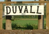
Duvall, Washington
Encyclopedia
Duvall is a city in King County
, Washington, United States
, located on SR 203, halfway between Monroe
and Carnation
. The population was 6,695 at the 2010 census.
 The area that became known as Duvall was historically the home of the Snoqualmie
and other ancestral Tulalip
Native American
tribes. Following their relocation under the Treaty of Point Elliott
, the area was homesteaded by veterans of the Civil War
. The center of present-day town was located on a hillside homesteaded by Francis and James Duvall, loggers who arrived in 1871.
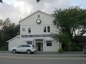
An early milestone in the settlement of Duvall proper was the relocation of the town of Cherry Valley. Around 1909, the Chicago, Milwaukee and St. Paul Railroad
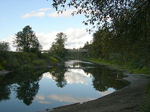
agreed to move Cherry Valley homes and businesses to Duvall in order to continue the construction of a railroad line along the Snoqualmie River
. The newly-relocated town, briefly named Cosgrove after Samuel G. Cosgrove
, underwent a real estate boom
; streets and sidewalks were laid and a train depot
was constructed. This was followed by construction of a movie house
, a drug store, a new schoolhouse, and several hotels. By 1911, the Duvall Citizen began publishing regular editions of news events.
On April 28, 1968, nearly 3,000 fans attended a rock concert at a farm in Duvall where an upright piano was dropped from a helicopter. Performances included Country Joe and the Fish
. This concert is well-known to locals as the Piano Drop. This event inspired the Sky River Rock Festival and Lighter Than Air Fair which occurred later that year.
The town of Duvall has experienced a great amount of construction during the period of 2008-2009 with the aim of making the one-road town center more accessible and presentable to tourists.
There were 1,646 housing units at an average density of 720.5 per square mile (278.7/km²). The racial makeup of the city was 93.46% White, 0.45% African American, 0.45% Native American, 1.97% Asian, 0.04% Pacific Islander, 1.49% from other races
, and 2.12% from two or more races. Hispanic or Latino of any race were 3.73% of the population.
There were 1,596 households out of which 49.4% had children under the age of 18 living with them, 71.4% were married couples
living together, 7.1% had a female householder with no husband present, and 18.1% were non-families. 13.2% of all households were made up of individuals and 2.5% had someone living alone who was 65 years of age or older. The average household size was 2.88 and the average family size was 3.15.
In the city the population was spread out with 32.4% under the age of 18, 5.0% from 18 to 24, 42.9% from 25 to 44, 16.5% from 45 to 64, and 3.2% who were 65 years of age or older. The median age was 33 years. For every 100 females there were 98.0 males. For every 100 females age 18 and over, there were 99.9 males.
The median income for a household in the city was $71,300, and the median income for a family was $78,740. Males had a median income of $51,164 versus $41,806 for females. The per capita income
for the city was $27,764. About 2.8% of families and 3.8% of the population were below the poverty line, including 5.2% of those under age 18 and none of those age 65 or over.
The day after Duvall Days is the day of the pancake breakfast, which is hosted by the town fire department and provides a breakfast of ham, eggs and pancakes.
Over the last ten years, certain aspects of the event have been banned each year. An example of this would be potato guns and silly string, both now officially banned from sale by vendors during the event. Although some aspects have been banned over the years, the event continues to grow in popularity.
According to the United States Census Bureau
, the city has a total area of 2.3 square miles (5.9 km²), all land.
King County, Washington
King County is a county located in the U.S. state of Washington. The population in the 2010 census was 1,931,249. King is the most populous county in Washington, and the 14th most populous in the United States....
, Washington, United States
United States
The United States of America is a federal constitutional republic comprising fifty states and a federal district...
, located on SR 203, halfway between Monroe
Monroe, Washington
Monroe is a city in Snohomish County, Washington, United States. The population as of 17,304 at the 2010 census.-History:The history of Monroe is intertwined with that of the Great Northern Railway which pushed over the Cascade Range at Stevens Pass and worked its way down the Skykomish River...
and Carnation
Carnation, Washington
Carnation is a city in King County, Washington, United States. The population was 1,786 at the 2010 census.-History:Settled in 1865, Carnation was officially incorporated on December 30, 1912, as Tolt. The name was changed to Carnation in 1917, back to Tolt on May 3, 1928, and finally back to...
. The population was 6,695 at the 2010 census.
History
Snoqualmie (tribe)
The Snoqualmie Tribe is a tribal government of Coast Salish Native American peoples from the Snoqualmie Valley in east King and Snohomish Counties in Washington state. The Snoqualmie settled onto the Tulalip Reservation after signing the Point Elliott Treaty with the Washington Territory in 1855...
and other ancestral Tulalip
Tulalip
Tulalip is a group of Native American peoples from western Washington state in the United States. Today they are federally recognized as the Tulalip Tribes of the Tulalip Reservation.- History :...
Native American
Indigenous peoples of the Americas
The indigenous peoples of the Americas are the pre-Columbian inhabitants of North and South America, their descendants and other ethnic groups who are identified with those peoples. Indigenous peoples are known in Canada as Aboriginal peoples, and in the United States as Native Americans...
tribes. Following their relocation under the Treaty of Point Elliott
Treaty of Point Elliott
The Treaty of Point Elliott of 1855, or the Point Elliott Treaty,—also known as Treaty of Point Elliot / Point Elliott Treaty—is the lands settlement treaty between the United States government and the nominal Native American tribes of the greater Puget Sound region in the recently-formed...
, the area was homesteaded by veterans of the Civil War
American Civil War
The American Civil War was a civil war fought in the United States of America. In response to the election of Abraham Lincoln as President of the United States, 11 southern slave states declared their secession from the United States and formed the Confederate States of America ; the other 25...
. The center of present-day town was located on a hillside homesteaded by Francis and James Duvall, loggers who arrived in 1871.
An early milestone in the settlement of Duvall proper was the relocation of the town of Cherry Valley. Around 1909, the Chicago, Milwaukee and St. Paul Railroad
Chicago, Milwaukee, St. Paul and Pacific Railroad
The Milwaukee Road, officially the Chicago, Milwaukee, St. Paul and Pacific Railroad , was a Class I railroad that operated in the Midwest and Northwest of the United States from 1847 until its merger into the Soo Line Railroad on January 1, 1986. The company went through several official names...
agreed to move Cherry Valley homes and businesses to Duvall in order to continue the construction of a railroad line along the Snoqualmie River
Snoqualmie River
The Snoqualmie River is a long river in King County and Snohomish County in the U.S. state of Washington. The river's three main tributaries are the North, Middle, and South Forks, which drain the west side of the Cascade Mountains near the town of North Bend and join near the town of Snoqualmie...
. The newly-relocated town, briefly named Cosgrove after Samuel G. Cosgrove
Samuel G. Cosgrove
Samuel Goodlove Cosgrove was the sixth Governor of the state of Washington, and was from Pomeroy, Washington. He was a U.S. Civil War veteran and educator. He served for one day before leaving for California for health reasons. He died in California shortly thereafter...
, underwent a real estate boom
Boom and bust
A credit boom-bust cycle is an episode characterized by a sustained increase in several economics indicators followed by a sharp and rapid contraction. Commonly the boom is driven by a rapid expansion of credit to the private sector accompanied with rising prices of commodities and stock market index...
; streets and sidewalks were laid and a train depot
Train station
A train station, also called a railroad station or railway station and often shortened to just station,"Station" is commonly understood to mean "train station" unless otherwise qualified. This is evident from dictionary entries e.g...
was constructed. This was followed by construction of a movie house
Nickelodeon movie theater
The Nickelodeon was a multi-purpose theater that was popular from about 1900 to 1914. Usually situated in converted storefronts, the Nickelodeon featured motion pictures, illustrated songs, slide shows and lectures...
, a drug store, a new schoolhouse, and several hotels. By 1911, the Duvall Citizen began publishing regular editions of news events.
On April 28, 1968, nearly 3,000 fans attended a rock concert at a farm in Duvall where an upright piano was dropped from a helicopter. Performances included Country Joe and the Fish
Country Joe and the Fish
Country Joe and the Fish was a rock band most widely known for musical protests against the Vietnam War, from 1966 to 1971, and also regarded as a seminal influence to psychedelic rock.-History:...
. This concert is well-known to locals as the Piano Drop. This event inspired the Sky River Rock Festival and Lighter Than Air Fair which occurred later that year.
The town of Duvall has experienced a great amount of construction during the period of 2008-2009 with the aim of making the one-road town center more accessible and presentable to tourists.
Demographics
There were 1,646 housing units at an average density of 720.5 per square mile (278.7/km²). The racial makeup of the city was 93.46% White, 0.45% African American, 0.45% Native American, 1.97% Asian, 0.04% Pacific Islander, 1.49% from other races
Race (United States Census)
Race and ethnicity in the United States Census, as defined by the Federal Office of Management and Budget and the United States Census Bureau, are self-identification data items in which residents choose the race or races with which they most closely identify, and indicate whether or not they are...
, and 2.12% from two or more races. Hispanic or Latino of any race were 3.73% of the population.
There were 1,596 households out of which 49.4% had children under the age of 18 living with them, 71.4% were married couples
Marriage
Marriage is a social union or legal contract between people that creates kinship. It is an institution in which interpersonal relationships, usually intimate and sexual, are acknowledged in a variety of ways, depending on the culture or subculture in which it is found...
living together, 7.1% had a female householder with no husband present, and 18.1% were non-families. 13.2% of all households were made up of individuals and 2.5% had someone living alone who was 65 years of age or older. The average household size was 2.88 and the average family size was 3.15.
In the city the population was spread out with 32.4% under the age of 18, 5.0% from 18 to 24, 42.9% from 25 to 44, 16.5% from 45 to 64, and 3.2% who were 65 years of age or older. The median age was 33 years. For every 100 females there were 98.0 males. For every 100 females age 18 and over, there were 99.9 males.
The median income for a household in the city was $71,300, and the median income for a family was $78,740. Males had a median income of $51,164 versus $41,806 for females. The per capita income
Per capita income
Per capita income or income per person is a measure of mean income within an economic aggregate, such as a country or city. It is calculated by taking a measure of all sources of income in the aggregate and dividing it by the total population...
for the city was $27,764. About 2.8% of families and 3.8% of the population were below the poverty line, including 5.2% of those under age 18 and none of those age 65 or over.
Town events
Every spring/summer there is a festival held titled "Duvall Days", also known as Coe's Day. The event is typically marked by a parade (which was cancelled in 2002 due to complaints regarding noise and/or littering, then later reinstated by citizen request), street side vendors, live entertainment, and many games and activities for children. The day kicks off with the Duvall Fun Run that includes both a 10-kilometer and 5-kilometer race.The day after Duvall Days is the day of the pancake breakfast, which is hosted by the town fire department and provides a breakfast of ham, eggs and pancakes.
Over the last ten years, certain aspects of the event have been banned each year. An example of this would be potato guns and silly string, both now officially banned from sale by vendors during the event. Although some aspects have been banned over the years, the event continues to grow in popularity.
Geography
Duvall is located at 47°44′3"N 121°58′32"W (47.734149, -121.975493).According to the United States Census Bureau
United States Census Bureau
The United States Census Bureau is the government agency that is responsible for the United States Census. It also gathers other national demographic and economic data...
, the city has a total area of 2.3 square miles (5.9 km²), all land.