
Skokomish River
Encyclopedia
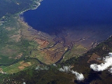
The Skokomish River is a river
in Mason County, Washington, United States
. It is the largest river flowing into Hood Canal
, an arm of Puget Sound
. From its source at the confluence of the North and South Forks the main stem Skokomish River is approximately 9 miles (14.5 km) long. The longer South Fork Skokomish River is 40 miles (64.4 km), making the length of the whole river via its longest tributary about 49 miles (78.9 km). The North Fork Skokomish River is approximately 34 miles (54.7 km) long. A significant part of the Skokomish River's watershed
is within Olympic National Forest
and Olympic National Park
.
, mainly in Mason County but including a portion of Jefferson County
. The main stem Skokomish River is formed by the confluence of the North Fork and South Fork near small community of Mohrweis. It flows east through the broad Skokomish Valley. After being crossed by U.S. Route 101
the river turns northeast. Washington State Route 106 crosses the river near its mouth on Hood Canal
. Near the towns of Union
and Skokomish
the Skokomish River enters Annas Bay at the The Great Bend of Hood Canal from the south, where it creates a large estuary called Skokomish Flats. The lower portion of the river flows through the Skokomish Indian Reservation
.
The South Fork Skokomish River originates near Sundown Pass in Olympic National Park
, near the sources of the Wynoochee River
and Graves Creek, a tributary of the Quinault River
. The South Fork flows southeast out of the national park and between Capitol Peak, on the west, and Wonder Mountain on the east. After receiving Rule Creek from the west the South Fork turns more directly south and enters a broader valley. It receives Church Creek from the west, then turns to flow southeast and east through a widening river valley. A number of tributary streams join the South Fork, including Pine Creek and Cedar Creek, from the south, and Le Bar Creek, Brown Creek, and Harp Creek from the north. The South Fork Skokomish leaves the main Olympic Mountains and enters flatter terrain, but flows through gorges for several miles. After exiting the gorges the South Fork turns east and enters the broad Skokomish Valley where it joins with the North Fork to form the main stem Skokomish River.
The North Fork Skokomish River originates on the northern slopes of Mount Skokomish. It flows west into Olympic National Park. The valley of the North Fork Skokomish is used for one of the national park's main backcountry hiking trails. At "Campground Nine Stream" the river turns south. It flows by "Campground Big Log", turns southeast and receives a number of tributaries including Four Stream and Slate Creek. The river rushes over Staircase Rapids shortly upriver from Staircase Campground and the national park's Ranger Station Staircase. The Staircase area is the main entry into the southeast portion of Olympic National Park. The North Fork receives Elk Creek at the campground and Lincoln Creek shortly downstream. The river then meanders southeast into Lake Cushman
, a reservoir created to supply Tacoma
with electricity. The tributary Big Creek enters the lake near Lake Cushman State Park. The North Fork exits Lake Cushman's southern end and flows a short distance to another reservoir, Lake Kokanee
, from which it flows south into the Skokomish Valley to join the South Fork, forming the main stem Skokomish River. Lake Cushman and Lake Kokanee are maintained by Cushman Dam No. 1
and Cushman Dam No. 2
respectively.
Until recently the entire flow of the North Fork is normally diverted at Cushman Dam No. 2, except for instream flow requirements and infrequent larger releases. On January 12, 2009, Tacoma Power, the Skokomish Tribe, and state and federal agencies signed settlement agreements that resolved long-standing disputes and damage claims relating to the Cushma Hydroelectric Project. As part of the settlement water will be released into the North Fork Skokomish River below the dams in order to mimic natural flow.
The name "Skokomish" comes from the Twana sqʷuqʷóʔbəš, also spelled sqWuqWu'b3sH, and meaning "river people" or "people of the river". The Skokomish were one of the largest of the nine different Twana village communities that existed before about 1860. By their locations, the nine groups were the Dabop, Quilcene, Dosewallips, Duckabush, Hoodsport, Skokomish, Vance Creek, Tahuya, and Duhlelap communities. Within these nine communities there were at least 33 settlements.
The South Fork's drainage was heavily logged, although logging has been discontinued in the Olympic National Forest since the late 1980s.
 The Skokomish is the most flood-prone river in Washington State, as it is the first river to flood during any major rain event. It set an all-time record-high flood level on December 3, 2007 when an intense tropical rainstorm moved in following several inches of snow from the day prior. Its maximum discharge of 29000 cubic feet (821.2 m³) per second, recorded on December 3, 2007, was more than twenty times its mean flow, and bested its previous record set on November 5, 1934 at more than 27000 cubic feet (764.6 m³) per second. The floods completely ripped up Highway 101 through the Skokomish Valley, resulting in two-day closure while emergency repairs were made. The 2007 flood event prompted Mason County officials and the Washington Department of Transportation to design and construct a newer, elevated roadway structure over the area of Purdy Creek, which is the lowest point in elevation in the valley that Highway 101 crosses. After 16 months of planning and construction, a 350-foot bridge elevated 12 feet higher than the original roadway was opened in July, 2009.
One notable flood in 1996 closed U.S. Route 101 and State Route 106 for four days, stranding a KOMO TV news crew from Seattle. Typically, these floods on the Skokomish spawn scores of Seattle TV news crews and print journalists to the scene, and is not unheard of for stories of Skokomish River floods by the media to include the joke "Why did the salmon cross the road?"
The combination of extensive clearcut logging, the damming of the North Fork, and winter-weather rain patterns are the primary reasons for the flooding that occurs almost every year on the South Fork. In late fall through early spring, storms often come from the southwest. These usually drop the most rain in the vicinity of the Skokomish River due to the topography of the Olympic Peninsula. It is suspected that tectonic uplift of the land may be contributing to the unusually frequent flooding that has plagued the Skokomish, even prior any major anthropogenic disturbances.
River
A river is a natural watercourse, usually freshwater, flowing towards an ocean, a lake, a sea, or another river. In a few cases, a river simply flows into the ground or dries up completely before reaching another body of water. Small rivers may also be called by several other names, including...
in Mason County, Washington, United States
United States
The United States of America is a federal constitutional republic comprising fifty states and a federal district...
. It is the largest river flowing into Hood Canal
Hood Canal
Hood Canal is a fjord forming the western lobe, and one of the four main basins, of Puget Sound in the state of Washington. Hood Canal is not a canal in the sense of being a man-made waterway—it is a natural waterway.-Geography:...
, an arm of Puget Sound
Puget Sound
Puget Sound is a sound in the U.S. state of Washington. It is a complex estuarine system of interconnected marine waterways and basins, with one major and one minor connection to the Strait of Juan de Fuca and the Pacific Ocean — Admiralty Inlet being the major connection and...
. From its source at the confluence of the North and South Forks the main stem Skokomish River is approximately 9 miles (14.5 km) long. The longer South Fork Skokomish River is 40 miles (64.4 km), making the length of the whole river via its longest tributary about 49 miles (78.9 km). The North Fork Skokomish River is approximately 34 miles (54.7 km) long. A significant part of the Skokomish River's watershed
Drainage basin
A drainage basin is an extent or an area of land where surface water from rain and melting snow or ice converges to a single point, usually the exit of the basin, where the waters join another waterbody, such as a river, lake, reservoir, estuary, wetland, sea, or ocean...
is within Olympic National Forest
Olympic National Forest
Olympic National Forest is a U.S. National Forest located in Washington, USA. With an area of 633,677 acres , it nearly surrounds Olympic National Park and the Olympic Mountain range. Olympic National Forest contains parts of Clallam, Grays Harbor, Jefferson, and Mason counties...
and Olympic National Park
Olympic National Park
Olympic National Park is located in the U.S. state of Washington, in the Olympic Peninsula. The park can be divided into four basic regions: the Pacific coastline, alpine areas, the west side temperate rainforest and the forests of the drier east side. U.S...
.
Course
The Skokomish River and its two tributary forks drain the southeast corner of the Olympic MountainsOlympic Mountains
The Olympic Mountains is a mountain range on the Olympic Peninsula of western Washington in the United States. The mountains, part of the Pacific Coast Ranges, are not especially high - Mount Olympus is the highest at - but the western slopes of the Olympics rise directly out of the Pacific...
, mainly in Mason County but including a portion of Jefferson County
Jefferson County, Washington
Jefferson County is a county located in the U.S. state of Washington, named after Thomas Jefferson. As of 2010, the population was 29,872. The county seat is at Port Townsend, which is also the county's only incorporated city....
. The main stem Skokomish River is formed by the confluence of the North Fork and South Fork near small community of Mohrweis. It flows east through the broad Skokomish Valley. After being crossed by U.S. Route 101
U.S. Route 101
U.S. Route 101, or U.S. Highway 101, is an important north–south U.S. highway that runs through the states of California, Oregon, and Washington, on the West Coast of the United States...
the river turns northeast. Washington State Route 106 crosses the river near its mouth on Hood Canal
Hood Canal
Hood Canal is a fjord forming the western lobe, and one of the four main basins, of Puget Sound in the state of Washington. Hood Canal is not a canal in the sense of being a man-made waterway—it is a natural waterway.-Geography:...
. Near the towns of Union
Union, Washington
Union is a small unincorporated community in Mason County, Washington, United States. The town lies along the southern shore of Hood Canal, at an area known as "the Great Bend". There is no U.S. Census data for the location...
and Skokomish
Skokomish, Washington
Skokomish is a census-designated place in Mason County, Washington, United States. The population was 616 at the 2000 census.-Geography:Skokomish is located at ....
the Skokomish River enters Annas Bay at the The Great Bend of Hood Canal from the south, where it creates a large estuary called Skokomish Flats. The lower portion of the river flows through the Skokomish Indian Reservation
Skokomish (tribe)
The Skokomish are one of nine tribes of the Twana, a Native American people of western Washington state in the United States. The tribe lives along Hood Canal, a fjord-like inlet on the west side of the Kitsap Peninsula and the Puget Sound basin...
.
The South Fork Skokomish River originates near Sundown Pass in Olympic National Park
Olympic National Park
Olympic National Park is located in the U.S. state of Washington, in the Olympic Peninsula. The park can be divided into four basic regions: the Pacific coastline, alpine areas, the west side temperate rainforest and the forests of the drier east side. U.S...
, near the sources of the Wynoochee River
Wynoochee River
The Wynoochee River is a long river located in the Olympic Peninsula in the U.S. state of Washington. A tributary of the Chehalis River, the Wynoochee River rises in the Olympic Mountains within the Olympic National Park and flows generally south. Its drainage basin is in area...
and Graves Creek, a tributary of the Quinault River
Quinault River
The Quinault River is a long river located on the Olympic Peninsula in the U.S. state of Washington. It originates deep in the Olympic Mountains in the Olympic National Park. It flows southwest through the "Enchanted Valley". Several miles above Lake Quinault the river is joined by its main...
. The South Fork flows southeast out of the national park and between Capitol Peak, on the west, and Wonder Mountain on the east. After receiving Rule Creek from the west the South Fork turns more directly south and enters a broader valley. It receives Church Creek from the west, then turns to flow southeast and east through a widening river valley. A number of tributary streams join the South Fork, including Pine Creek and Cedar Creek, from the south, and Le Bar Creek, Brown Creek, and Harp Creek from the north. The South Fork Skokomish leaves the main Olympic Mountains and enters flatter terrain, but flows through gorges for several miles. After exiting the gorges the South Fork turns east and enters the broad Skokomish Valley where it joins with the North Fork to form the main stem Skokomish River.
The North Fork Skokomish River originates on the northern slopes of Mount Skokomish. It flows west into Olympic National Park. The valley of the North Fork Skokomish is used for one of the national park's main backcountry hiking trails. At "Campground Nine Stream" the river turns south. It flows by "Campground Big Log", turns southeast and receives a number of tributaries including Four Stream and Slate Creek. The river rushes over Staircase Rapids shortly upriver from Staircase Campground and the national park's Ranger Station Staircase. The Staircase area is the main entry into the southeast portion of Olympic National Park. The North Fork receives Elk Creek at the campground and Lincoln Creek shortly downstream. The river then meanders southeast into Lake Cushman
Lake Cushman
Lake Cushman is a lake and reservoir on the north fork of the Skokomish River in Mason County, Washington. The lake originally was a long narrow broadening of the Skokomish River formed in a glacial trough and dammed by a terminal moraine from the last ice age, during the Vashon stade.The lake was...
, a reservoir created to supply Tacoma
Tacoma, Washington
Tacoma is a mid-sized urban port city and the county seat of Pierce County, Washington, United States. The city is on Washington's Puget Sound, southwest of Seattle, northeast of the state capital, Olympia, and northwest of Mount Rainier National Park. The population was 198,397, according to...
with electricity. The tributary Big Creek enters the lake near Lake Cushman State Park. The North Fork exits Lake Cushman's southern end and flows a short distance to another reservoir, Lake Kokanee
Lake Kokanee
Lake Kokanee, also known as Lower Lake Cushman, is a 150 acre reservoir on the North Fork of the Skokomish River in Mason County, Washington. The lake is maintained by Cushman Dam No. 2, providing electrical power to the Tacoma Power system....
, from which it flows south into the Skokomish Valley to join the South Fork, forming the main stem Skokomish River. Lake Cushman and Lake Kokanee are maintained by Cushman Dam No. 1
Cushman Dam No. 1
Cushman Dam No. 1 is a hydroelectric dam on the North Fork of the Skokomish River in Mason County, Washington forming Lake Cushman. It was built by Tacoma City Light in 1924-1926. Tacoma's demand for electricity grew rapidly after World War I...
and Cushman Dam No. 2
Cushman Dam No. 2
Cushman Dam No. 2 is a hydroelectric dam on the North Fork of the Skokomish River in Mason County, Washington, United States, forming Lake Kokanee. Built in 1930, its three 27,000 kilowatt generators provide 233 million kilowatt-hours annually to the Tacoma Power system. Along with Cushman Dam No...
respectively.
Until recently the entire flow of the North Fork is normally diverted at Cushman Dam No. 2, except for instream flow requirements and infrequent larger releases. On January 12, 2009, Tacoma Power, the Skokomish Tribe, and state and federal agencies signed settlement agreements that resolved long-standing disputes and damage claims relating to the Cushma Hydroelectric Project. As part of the settlement water will be released into the North Fork Skokomish River below the dams in order to mimic natural flow.
History
Prior to the construction of the Cushman Hydroelectric Project, the Skokomish River was once Washington State's largest and most productive salmon-producing river.The name "Skokomish" comes from the Twana sqʷuqʷóʔbəš, also spelled sqWuqWu'b3sH, and meaning "river people" or "people of the river". The Skokomish were one of the largest of the nine different Twana village communities that existed before about 1860. By their locations, the nine groups were the Dabop, Quilcene, Dosewallips, Duckabush, Hoodsport, Skokomish, Vance Creek, Tahuya, and Duhlelap communities. Within these nine communities there were at least 33 settlements.
The South Fork's drainage was heavily logged, although logging has been discontinued in the Olympic National Forest since the late 1980s.
Flooding
One notable flood in 1996 closed U.S. Route 101 and State Route 106 for four days, stranding a KOMO TV news crew from Seattle. Typically, these floods on the Skokomish spawn scores of Seattle TV news crews and print journalists to the scene, and is not unheard of for stories of Skokomish River floods by the media to include the joke "Why did the salmon cross the road?"
The combination of extensive clearcut logging, the damming of the North Fork, and winter-weather rain patterns are the primary reasons for the flooding that occurs almost every year on the South Fork. In late fall through early spring, storms often come from the southwest. These usually drop the most rain in the vicinity of the Skokomish River due to the topography of the Olympic Peninsula. It is suspected that tectonic uplift of the land may be contributing to the unusually frequent flooding that has plagued the Skokomish, even prior any major anthropogenic disturbances.
External links
- Salmon, Tribes, and Hydropower Dams in the U.S. Puget Sound
- Cushman Hydro Project Statistics
- Skokomish River Basin, USGS
- Skokomish Watershed, Surf Your Watershed, EPAUnited States Environmental Protection AgencyThe U.S. Environmental Protection Agency is an agency of the federal government of the United States charged with protecting human health and the environment, by writing and enforcing regulations based on laws passed by Congress...