

Seattle Fault
Encyclopedia
Puget Sound faults
The Puget Sound faults under the heavily populated Puget Sound region of Washington state form a regional complex of interrelated seismogenic geologic faults...
.
Notable earthquake
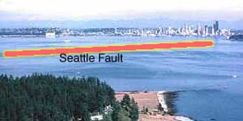
First suspected from mapping of gravitational anomalies in 1965 and an uplifted marine terraceMarine terrace
A marine terrace, coastal terrace, raised beach or perched coastline is a relatively flat, horizontal or gently inclined surface of marine origin, mostly an old abrasion platform which has been lifted out of the sphere of wave activity . Thus it lies above or under the current sea level, depending...
at Restoration Point (foreground in picture above), the Seattle Fault's existence and likely hazard was definitely established by a set of five reports published in Science in 1992. These reports looked at the timing of abrupt uplift and subsidence around Restoration Point and Alki Point (distant right side of picture), tsunami deposit
Tsunami deposit
A tsunami deposit is a sedimentary unit deposited as the result of of a tsunami. Such deposits may be left onshore during the inundation phase or offshore during the 'backwash' phase. Such deposits are being used to identify past tsunami events and thereby better constrain estimates of both...
s on Puget Sound, turbidity in lake paleosediments, rock avalanches, and multiple landslides around Lake Washington, and determined that all these happened about 1100 years ago (between A.D. 900–930), and most likely due to an earthquake of magnitude 7 or greater on the Seattle Fault.
Geology
Tertiary
The Tertiary is a deprecated term for a geologic period 65 million to 2.6 million years ago. The Tertiary covered the time span between the superseded Secondary period and the Quaternary...
) basalt
Basalt
Basalt is a common extrusive volcanic rock. It is usually grey to black and fine-grained due to rapid cooling of lava at the surface of a planet. It may be porphyritic containing larger crystals in a fine matrix, or vesicular, or frothy scoria. Unweathered basalt is black or grey...
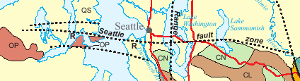
of the Crescent Formation on the south has been uplifted – the Seattle Uplift – and is tipping into the Seattle Basin, where the Tertiary bedrock is buried under at least 7 km of relatively softer, lighter sedimentary strata of the younger Blakeley and Blakely Harbor formations. This has resulted in a 4- to 7-km wide zone of complex faulting, with three or more main south-dipping thrust faults. Most of the faulting is "blind" (not reaching the surface), and generally difficult to locate because of the generally heavy vegetation or development. Three principal strands have been identified, their location determined by high-resolution seismic reflection and aeromagnetic
Aeromagnetic survey
An aeromagnetic survey is a common type of geophysical survey carried out using a magnetometer aboard or towed behind an aircraft. The principle is similar to a magnetic survey carried out with a hand-held magnetometer, but allows much larger areas of the Earth's surface to be covered quickly for...
surveys. The northernmost strand lies nearly along Interstate 90 and then under Lake Sammamish
Lake Sammamish
Lake Sammamish is a freshwater lake east of Seattle in King County, Washington, United States. The lake is long and wide, with a maximum depth of and a surface area of . It lies east of Lake Washington and west of the Sammamish Plateau, and stretches from Issaquah in the south to Redmond in...
. The central section of the fault zone – where it crosses the apparent location of the Olympic-Wallowa Lineament
Olympic-Wallowa Lineament
The Olympic-Wallowa lineament – first reported by cartographer Erwin Raisz in 1945 on a relief map of the continental United States – is a physiographic feature of unknown origin in the state of Washington running approximately from the town of Port Angeles, on the Olympic Peninsula...
– shows marked variation in the location of the strands and of the underlying structure, but the nature and significance of this is not understood.
The fault extends for approximately 70 km (43 miles) from near Fall City
Fall City, Washington
Fall City is a census-designated place in King County, Washington, United States. Located 26 miles east of Seattle, the community lies along the Snoqualmie River. The population was 1,993 at the 2010 census...
on the east, where it appears to be terminated by the South Whidbey Island Fault, to Hood Canal
Hood Canal
Hood Canal is a fjord forming the western lobe, and one of the four main basins, of Puget Sound in the state of Washington. Hood Canal is not a canal in the sense of being a man-made waterway—it is a natural waterway.-Geography:...
on the west (not shown on the map). where matters are as yet unclear (see discussion at Puget Sound faults#Question of western termination). It is the northern edge of the Seattle Uplift, of which the Tacoma Fault
Tacoma Fault
The Tacoma Fault, just north of the city of Tacoma, Washington, is an active east–west striking north dipping reverse fault with approximately 35 miles of identified surface rupture...
is the southern edge. One model has the Seattle and Tacoma faults converging at depth to form a wedge, which is being popped up by approximately north—south oriented compression that ultimately derives from plate tectonics. Another model (see diagram) interprets the Seattle Uplift as a sheet of rock that is being forced up a ramp. Subsequent work suggests that the structure of the Seattle Fault may vary from east to west, with both models being applicable in different sections. A later model has part of the north-thrusting sheet forming a wedge between the sedimentary formations of the Seattle Basin and the underlying bedrock.
The Seattle Fault is believed to date from about 40 million years ago (late Eocene
Eocene
The Eocene Epoch, lasting from about 56 to 34 million years ago , is a major division of the geologic timescale and the second epoch of the Paleogene Period in the Cenozoic Era. The Eocene spans the time from the end of the Palaeocene Epoch to the beginning of the Oligocene Epoch. The start of the...
). This is about the time that the strike-slip movement on the north-striking Straight Creek Fault
Straight Creek Fault
The Straight Creek Fault is the principal north-south strike-slip fault in the state of Washington, with a minimum of 90 kilometers of right-lateral offset, and a major geological structure in the North Cascade mountains, where it separates the pre-Tertiary igneous and metamorphic rocks of the...
to the east ceased, due to the intrusions of plutons. It appears that when the Straight Creek Fault became stuck the north–south compressive force that it had accommodated by strike-slip motion was transferred to the crust of the Puget Lowland, which subsequently folded and faulted, and the various blocks jammed over one another.
Other scarps associated with the Seattle fault have been identified by LIDAR
LIDAR
LIDAR is an optical remote sensing technology that can measure the distance to, or other properties of a target by illuminating the target with light, often using pulses from a laser...
-based mapping; trenching has generally shown the faulting to be more complex than was first realized. Many of the details of the Seattle Fault, including recurrence rate, remain to be resolved. A study of sediments in Lake Washington found evidence of seven large (M > 7) earthquakes in the last 3500 years.
Surface scarps
Fault scarp
A fault scarp is the topographic expression of faulting attributed to the displacement of the land surface by movement along faults. They are exhibited either by differential movement and subsequent erosion along an old inactive geologic fault , or by a movement on a recent active fault...
due to faulting are rarely observed in this area (due to topography, vegetation, and urbanization); a rare exception can be seen at Mee Kwa Mooks Park south of Alki Point. The is the site of the West Seattle Fault; the prominent rise there is due to uplift on the north side of the fault.
Hazard
The Seattle Fault (and the related Tacoma FaultTacoma Fault
The Tacoma Fault, just north of the city of Tacoma, Washington, is an active east–west striking north dipping reverse fault with approximately 35 miles of identified surface rupture...
) is not the only source of earthquake hazard in the Puget Lowland. Other faults in the near surface continental crust, such as the South Whidbey Island Fault (near Everett), and the yet to be studied Olympia Fault (near Olympia), though historically quiescent, are suspected of generating earthquakes of around magnitude 7. Others, such as the 2001 Nisqually earthquake, originate about 50 to 60 km below Puget Sound in the Benioff zone
Benioff zone
A Wadati–Benioff zone is a deep active seismic area in a subduction zone. Differential motion along the zone produces deep-seated earthquakes, the foci of which may be as deep as about . They develop beneath volcanic island arcs and continental margins above active subduction zones...
of the subducting Juan de Fuca plate
Juan de Fuca Plate
The Juan de Fuca Plate, named after the explorer of the same name, is a tectonic plate, generated from the Juan de Fuca Ridge, and subducting under the northerly portion of the western side of the North American Plate at the Cascadia subduction zone...
; being so deep their energy is dissipated. And there are the infrequent but very powerful great subduction events, such as the magnitude 9 1700 Cascadia earthquake, where the entire Cascadia subduction zone
Cascadia subduction zone
The Cascadia subduction zone is a subduction zone, a type of convergent plate boundary that stretches from northern Vancouver Island to northern California. It is a very long sloping fault that separates the Juan de Fuca and North America plates.New ocean floor is being created offshore of...
, from Cape Mendocino
Cape Mendocino
Cape Mendocino located on the Lost Coast entirely within Humboldt County, California, USA, is the westernmost point on the coast of California. It has been a landmark since the 16th century when the Manila Galleons would reach the coast here following the prevailing westerlies all the way across...
to Vancouver Island
Vancouver Island
Vancouver Island is a large island in British Columbia, Canada. It is one of several North American locations named after George Vancouver, the British Royal Navy officer who explored the Pacific Northwest coast of North America between 1791 and 1794...
, slips.
But the Seattle and Tacoma faults are probably the most serious earthquake threat to the populous Seattle—Tacoma area. A 2002 study of bridge vulnerability estimated that a magnitude 7 earthquake on the Seattle Fault would damage approximately 80 bridges in the Seattle—Tacoma area, whereas a magnitude 9 subduction event would damage only around 87 bridges in all of Western Washington. The same study also found that with failure of just six bridges (the minimum damage for a Benioff M 6.5 event) there could be at least $3 billion lost in business revenue alone. Subsequent retrofitting by the Washington Department of Transportation and the City of Seattle would likely reduce damage to key bridges. But there is concern that such an earthquake on the Seattle Fault would devastate unreinforced masonry (URM) buildings, of which the City of Seattle is estimated to have around a thousand, concentrated in Capitol Hill, Pioneer Square, and the International District.
Other recent work indicates that the Seattle Fault can generate two types of earthquakes; both pose "considerable hazard" to the Seattle metropolitan region. The A.D. 900–930 earthquake is believed to be the only instance in the past 7,000 years of the type that causes a regional uplift. The other type is more localized and shallower (and therefore more damaging); at least four such events are believed to have occurred in the past 3,000 years on the west end of the fault. (The history of the central and eastern segments is not known.)
Calculations based on fault length and paleoseismological studies show that the Seattle Fault can generate a very damaging magnitude 7.0 earthquake. In addition to extensive damage to unreinforced structures and structures built on fill (such as much of Seattle's Pioneer Square area, the industrial area, and the waterfront), computer modeling has shown that such earthquakes could cause a tsunami of about 2 meters (6 feet) high on Elliott Bay. The modeling shows that such a tsunami would also inundate the industrial areas on Commencement Bay 30 miles south (Tacoma) and low-lying areas on the Puyallup River delta. There is also concern that a severe or prolonged event could cause failure of the Duwamish
Duwamish River
The Duwamish River is the name of the lower of Washington state's Green River. Its industrialized estuary is known as the Duwamish Waterway.- History :...
or Puyallup River
Puyallup River
The Puyallup River is a river in the U.S. state of Washington. About long, it is formed by glaciers on the west side of Mount Rainier. It flows generally northwest, emptying into Commencement Bay, part of Puget Sound...
deltas, where the main port facilities for Seattle and Tacoma are located (Harbor Island and Commencement Bay).
See also
- EarthquakeEarthquakeAn earthquake is the result of a sudden release of energy in the Earth's crust that creates seismic waves. The seismicity, seismism or seismic activity of an area refers to the frequency, type and size of earthquakes experienced over a period of time...
- Tacoma FaultTacoma FaultThe Tacoma Fault, just north of the city of Tacoma, Washington, is an active east–west striking north dipping reverse fault with approximately 35 miles of identified surface rupture...
- Puget Sound faultsPuget Sound faultsThe Puget Sound faults under the heavily populated Puget Sound region of Washington state form a regional complex of interrelated seismogenic geologic faults...
- Geology of the Pacific NorthwestGeology of the Pacific NorthwestThe geology of the Pacific Northwest refers to the study of the composition , structure, physical properties and the processes that shape the Pacific Northwest region of the United States and Canada...
External links
- USGS Quaternary fault and fold database Technical description and bibliography for the Seattle Fault.
- USGS: Seattle Fault Zone Technical article.
- USGS Professional Paper 1560: Assessing Earthquake Hazards and Reducing Risk in the Pacific Northwest Technical, but readable. And has many good pictures.
- USGS: Reducing Earthquake Hazards in the Pacific Northwest
- USGS: Earthquake ground motion movies
- Serpent Spirit–power Stories along the Seattle Fault Indian legends of the Great Seattle Quake.
- Pinpointing devastation if Seattle Fault ruptures Seattle Times, February 20, 2005.
- Scenario for a Magnitude 6.7 Earthquake on the Seattle Fault Vivid and comprehensive.
- Unreinforced Masonry Building Seismic Hazards Study (City of Seattle)
- Washington State's Bridge Seismic Retrofit Program
- Earthquake Study: Four Vashon-Specific Scenarios Considerations for all islands.
- Puget Sound Tsunami Inundation Modeling (NOAA)
- Elliot Bay inundation map (DNR)
- Tsunami Hazard Map of the Elliott Bay Area (NOAA)
- Additional inundation maps (DNR Publications)
- Puget Sound Lidar Consortium Use of Lidar for locating faults.