

Pamir Highway
Encyclopedia
Russian language
Russian is a Slavic language used primarily in Russia, Belarus, Uzbekistan, Kazakhstan, Tajikistan and Kyrgyzstan. It is an unofficial but widely spoken language in Ukraine, Moldova, Latvia, Turkmenistan and Estonia and, to a lesser extent, the other countries that were once constituent republics...
: "Pamirsky Trakt", Памирский тракт) is a road traversing the Pamir Mountains
Pamir Mountains
The Pamir Mountains are a mountain range in Central Asia formed by the junction or knot of the Himalayas, Tian Shan, Karakoram, Kunlun, and Hindu Kush ranges. They are among the world’s highest mountains and since Victorian times they have been known as the "Roof of the World" a probable...
through Afghanistan
Afghanistan
Afghanistan , officially the Islamic Republic of Afghanistan, is a landlocked country located in the centre of Asia, forming South Asia, Central Asia and the Middle East. With a population of about 29 million, it has an area of , making it the 42nd most populous and 41st largest nation in the world...
, Uzbekistan
Uzbekistan
Uzbekistan , officially the Republic of Uzbekistan is a doubly landlocked country in Central Asia and one of the six independent Turkic states. It shares borders with Kazakhstan to the west and to the north, Kyrgyzstan and Tajikistan to the east, and Afghanistan and Turkmenistan to the south....
, Tajikistan
Tajikistan
Tajikistan , officially the Republic of Tajikistan , is a mountainous landlocked country in Central Asia. Afghanistan borders it to the south, Uzbekistan to the west, Kyrgyzstan to the north, and China to the east....
, and Kyrgyzstan
Kyrgyzstan
Kyrgyzstan , officially the Kyrgyz Republic is one of the world's six independent Turkic states . Located in Central Asia, landlocked and mountainous, Kyrgyzstan is bordered by Kazakhstan to the north, Uzbekistan to the west, Tajikistan to the southwest and China to the east...
in Central Asia
Central Asia
Central Asia is a core region of the Asian continent from the Caspian Sea in the west, China in the east, Afghanistan in the south, and Russia in the north...
. It is the only continuous route through the difficult terrain of the mountains and serves as the main supply route to Tajikistan's Gorno-Badakhshan Autonomous Region. The route has been in use for millennia, as there are a limited number of viable routes through the high Pamir Mountains. The road formed one link of the ancient Silk Road
Silk Road
The Silk Road or Silk Route refers to a historical network of interlinking trade routes across the Afro-Eurasian landmass that connected East, South, and Western Asia with the Mediterranean and European world, as well as parts of North and East Africa...
trade route.
Route description
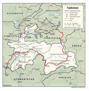
Sources disagree on the termini of the highway, with Mazari Sharif, Afghanistan; Termiz, Uzbekistan; Dushanbe, Tajikistan; and Khorog, Tajikistan all being offered as the beginning of the highway. All sources, however, agree that the highway ends in Osh, Kyrgyzstan. Today, the route is part of the M41 highway, which starts at Termiz at 37°12′39"N 67°16′20"E and ends at Kara-BaltaKara-Balta
Kara-Balta is a city and municipality on the Chu River, in Chuy Province, Kyrgyzstan, the capital of Jaiyl District. It was founded in 1825 under the Kokand Khanate, and received city status in 1975 under the Soviets. Its city population was officially 43,531 in a 2001 census...
to the west of Bishkek, Kyrgyzstan at 42°49′40"N 73°52′53"E. The route passes northward through Termiz before turning east and crossing into Tajikistan. It then follows a general eastward route through Dushanbe, the capital of Tajikistan, to Khorog
Khorog
The town of Khorugh , also transliterated as Khoroq, Khorogh, Khorog, or Xoroq) is the capital of the Gorno-Badakhshan Autonomous Province in Tajikistan. It is also the capital of the Shughnon District of Gorno-Badakhshan. It has a population of 28,000...
, crossing the Kafirnigan, Vakhsh
Vakhsh River
The Vakhsh has been intensively developed for human use. Electricity, aluminum, and cotton are the mainstays of Tajikistan’s economy, and the Vakhsh is involved with all three of these sectors. Hydroelectricity provides 91% of the country’s electricity as of 2005, and 90% of that total comes from...
, and Bartang Rivers. From there, it continues east for about 310 kilometers to Murghab
Murghab, Tajikistan
Murghab is the capital of Murghob District in the Pamir Mountains of Gorno-Badakhshan Autonomous Region, Tajikistan. With a population 4,000, Murghab is about the only significant town the eastern half of Gorno-Badakhshan...
, where it crosses the Murghab River. The highway then passes through the 4,655-meter (15,270 ft) high Ak-Baital pass
Mountain pass
A mountain pass is a route through a mountain range or over a ridge. If following the lowest possible route, a pass is locally the highest point on that route...
and past Lake Karakul before crossing into Kyrgyzstan to its terminus in Osh. The stretch of road between Khorog and Osh attracts a small amount of tourism due to its rugged natural beauty.
The Pamir Highway is designated as route M-41 over much of its length in Tajikistan and Kyrgyzstan, and is known as the second-highest altitude
Altitude
Altitude or height is defined based on the context in which it is used . As a general definition, altitude is a distance measurement, usually in the vertical or "up" direction, between a reference datum and a point or object. The reference datum also often varies according to the context...
international highway in the world (4,655 m). The section between Dushanbe and Murghab
Murghab, Tajikistan
Murghab is the capital of Murghob District in the Pamir Mountains of Gorno-Badakhshan Autonomous Region, Tajikistan. With a population 4,000, Murghab is about the only significant town the eastern half of Gorno-Badakhshan...
has the European route number E 008.
Construction and maintenance levels vary substantially along the highway. The roadway is paved is some areas, but is mostly unpaved. The road is heavily damaged in places by erosion
Erosion
Erosion is when materials are removed from the surface and changed into something else. It only works by hydraulic actions and transport of solids in the natural environment, and leads to the deposition of these materials elsewhere...
, earthquake
Earthquake
An earthquake is the result of a sudden release of energy in the Earth's crust that creates seismic waves. The seismicity, seismism or seismic activity of an area refers to the frequency, type and size of earthquakes experienced over a period of time...
s, landslide
Landslide
A landslide or landslip is a geological phenomenon which includes a wide range of ground movement, such as rockfalls, deep failure of slopes and shallow debris flows, which can occur in offshore, coastal and onshore environments...
s, and avalanche
Avalanche
An avalanche is a sudden rapid flow of snow down a slope, occurring when either natural triggers or human activity causes a critical escalating transition from the slow equilibrium evolution of the snow pack. Typically occurring in mountainous terrain, an avalanche can mix air and water with the...
s.
Popular culture
In the 1985 film Spies Like UsSpies Like Us
Spies Like Us is a 1985 American comedy film directed by John Landis and starring Chevy Chase, Dan Aykroyd, Steve Forrest, and Donna Dixon...
, the decoy GLG-20s played by Chevy Chase
Chevy Chase
Cornelius Crane "Chevy" Chase is an American comedian, writer, and television and film actor, born into a prominent entertainment industry family. Chase worked a plethora of odd jobs before moving into comedy acting with National Lampoon...
and Dan Aykroyd
Dan Aykroyd
Daniel Edward "Dan" Aykroyd, CM is a Canadian comedian, actor, screenwriter, musician, winemaker and ufologist. He was an original cast member of Saturday Night Live, an originator of The Blues Brothers and Ghostbusters and has had a long career as a film actor and screenwriter.-Early...
are told to meet their contacts on the "road to Dushanbe," a reference to the M41 highway.