
1991 Sino-Russian Border Agreement
Encyclopedia
The 1991 Sino-Soviet Border Agreement was a treaty
between the People's Republic of China
and the Soviet Union
that set up demarcation work to resolve most of the border disputes between the two states. Initially signed by China
and the Soviet Union
, the terms of the agreement were resumed by Russia after the breakup of the Soviet Union. The treaty resulted in some minor territorial changes along the border.
and the Russian Empire
, the Treaty of Aigun
and the Treaty of Beijing, in which Russia gained over 1 million km² (400,000 mi²) of territory in Manchuria
at China's expense, and another 500,000 km² in the western regions from several other treaties. These treaties have long been regarded by Chinese as unequal treaties
, and the issue partially arose again with the Sino-Soviet split, with tensions eventually leading to division-scale military clashes along the border in 1969.
Even as tensions lessened and leaders on both sides adopted more conciliatory attitudes, the border issue remained unresolved. Despite the view of the previous border treaties as unequal ones, Chinese leaders were willing to negotiate on the basis of the modern boundaries. That left about 35,000 km² of territory in dispute, with about 28,000 km² in the Pamir Mountains
of Tajikistan
, 6,000 km² elsewhere along the western border, and about 1,000 km² along the Argun
, Amur, and Ussuri rivers on the eastern border. Border negotiations were eventually resumed in 1987 at Mikhail Gorbachev
's initiation. An agreement was reached on the eastern portion of the border on May 16, 1991, several months before the final dissolution of the USSR. Russia inherited most of the former Sino-Soviet border, and ratified the agreement in February 1992, while the other post-Soviet republics negotiated separate border agreements.
. The location of the main channel and the possession of the various islands would be decided in the course of the demarcation work. Various other articles stipulate military, usage, and traffic rights along the river borders. Two areas, Heixiazi
and Abagaitu Islet
, were excluded from the agreement, and their status would not be resolved until 2004. According to the estimates by Boris Tkachenko, a Russian historian, the treaty resulted in net territorial gain for China, which received about 720 km², including some seven hundred islands. http://cio.ceu.hu/courses/CIO/modules/Module06Lomanov/Lomanov_06.html
Because islands on the Argun, Amur, and Ussuri rivers often split the rivers into multiple streams, the location of the main stream (and thus the border) was often not immediately apparent. Obviously, each country would receive a greater number of islands if the recognized main channel was closer to the opposite bank. Thus, the demarcation work was often controversial and subject to local protests over disputed territories. The demarcation work continued nearly up until its 1997 deadline.
 Menkeseli was a 17.5 km² (7 mi²) region along the Argun River that according to the agreement should have been transferred to China. However, this was opposed by local Russian civilians, who used this area for fishing, and by military officials, who cited security reasons. The dispute was finally finalized in 1996, in which the region would be transferred to China but local Russian residents would be guaranteed special usage rights to the region.
413 islands and islets along the river were disputed. The final apportionment has 204 islands in Russian territory and 209 islands in Chinese territory.
Specifically excluded from the agreement was the status of 5 km² (2 mi²) Abagaitu Islet
, on the border between China's Inner Mongolia
and Russia's Chita Oblast
and near the cities of Zabaykalsk
and Manzhouli
. In Chinese it is known by the Mongolian name of Abaigaitui, while the name in Russian is Bolshoy. This island would be transferred to China in subsequent agreements in 2004.
, the Soviet Union unilaterally occupied many of the islands along the Amur River and prevented Chinese locals from entering. These islands were the site of several military skirmishes during the 1960s. Most of the disputed islands have been transferred to China. Of the 1,680 islands along the Amur, the agreement now recognizes 902 Chinese islands and 708 Russian islands.
The two islands of Bolshoy Ussuriysky (32 km²) and Tarabarov island (4 km²) near Khabarovsk
, along the junction of the Amur and Ussuri rivers was specifically excluded from the agreement. The two islands are referred to collectively in Chinese as Heixiazi
, although the smaller Tarabarov is sometimes called Yinlong. The status of these islands was resolved in 2004, when Tarabarov and approximately 50% of Bolshoy Ussuriysky were transferred to China.
. Of the 320 islands along this river, the agreement recognizes 167 Russian islands and 153 Chinese islands.
Kutsuzov is the largest island along the Ussuri. Under former Chinese possession it was known as Daxitong dao. Control was transferred to the Soviet Union during the Manchukuo
period. Under the terms of the agreement, the island remained in Russia's possession.
Damansky, or Zhenbao Island
along the Ussuri River, was the site of the 1969 Damansky Island incident
. After the conflict, the Chinese appear to have retained de facto control over the island. The agreement recognized China's de jure as well as de facto control.
West of Lake Khanka lay a section of territory unilaterally seized from Manchukuo by the Soviet Union in 1933. This territory, about 0.70 to 0.9 km² (170 to 220 acres), has been transferred to Chinese control.
acquired control of the delta. The delta was later given to Manchukuo, which was then restored to China, but the Soviet Union retained control of the islands along the river. These islands have been transferred to China.
and Ussuriysky District (now Ussuriysk
urban district) of Primorsky Krai
. The original Convention of Peking
(Beijing) states this section of the border lies along the Granitnaya, but the origin of the river de facto lay inside Russian territory. With the 1991 agreement, Russia transferred 9 km² (3.5 mi²) to China so that now the Sino-Russian border runs along the entire length of the river.
. According to the agreement, 3 km² (1 mi²) of territory would be transferred to China, and Chinese ships would gain the right to navigate the Tumen river. The territory transfer would connect a previously enclaved piece of Chinese territory to the rest of China. This portion of the agreement stirred up some controversy among some Russian officials from Primorsky Krai, as they felt that direct Chinese access to the Sea of Japan
(through the Tumen River) would decrease the economic importance of Vladivostok
and Nakhodka
. Other arguments protested at potential pollution from Chinese economic development, the possibility of Chinese military vessels navigating the river, and the presence of a Russian cemetery commemorating the Lake Khasan Incident
in the area. Finally, in June 1997, the Russian side proposed a resolution which would divide the disputed territory in half. This was accepted by China in September of the same year, and in November, when the border demarcation work was declared finished, 1.6 km² (0.6 mi²) were transferred to China, and 1.4 km² (0.5 mi²) were retained by Russia. The Lake Khasan cemetery remained on the Russian side, and the Chinese officials underwent informal agreements to not build a port along the Tumen River.
). The Convention of Peking
(Beijing) set the location of border at 24 km (15 mi) above the mouth of the river, where it enters the Sea of Japan, but through Chinese negotiation was later moved to about 15 or 16 km (9 mi) above the mouth. In 1964, both sides agreed to a border about 17 km (11 mi) above the mouth, and these terms were kept in the 1991 agreement. However, the Russian side preferred it to be set at 24 km, and the Chinese at 15 km. The final position was set at 18.3 km (11.3 mi) above the mouth of the river.
The final position of the triangular border, where the People's Republic of China, Russia, and North Korea meet, was successfully demarcated in 1998 after trilateral negotiations from all three countries, and went into effect 1999.
now based in Taiwan
does not recognize any Chinese territorial changes based on any border agreements signed by the People's Republic of China with any other countries, including this 1991 one, due to the requirements in the Constitution of the Republic of China
and its Additional Articles.
criticism of the treaty
Treaty
A treaty is an express agreement under international law entered into by actors in international law, namely sovereign states and international organizations. A treaty may also be known as an agreement, protocol, covenant, convention or exchange of letters, among other terms...
between the People's Republic of China
People's Republic of China
China , officially the People's Republic of China , is the most populous country in the world, with over 1.3 billion citizens. Located in East Asia, the country covers approximately 9.6 million square kilometres...
and the Soviet Union
Soviet Union
The Soviet Union , officially the Union of Soviet Socialist Republics , was a constitutionally socialist state that existed in Eurasia between 1922 and 1991....
that set up demarcation work to resolve most of the border disputes between the two states. Initially signed by China
People's Republic of China
China , officially the People's Republic of China , is the most populous country in the world, with over 1.3 billion citizens. Located in East Asia, the country covers approximately 9.6 million square kilometres...
and the Soviet Union
Soviet Union
The Soviet Union , officially the Union of Soviet Socialist Republics , was a constitutionally socialist state that existed in Eurasia between 1922 and 1991....
, the terms of the agreement were resumed by Russia after the breakup of the Soviet Union. The treaty resulted in some minor territorial changes along the border.
Background
The border between the Soviet Union and the People's Republic of China had long been an issue of contention. The Sino-Soviet border was a legacy of various treaties between the Qing DynastyQing Dynasty
The Qing Dynasty was the last dynasty of China, ruling from 1644 to 1912 with a brief, abortive restoration in 1917. It was preceded by the Ming Dynasty and followed by the Republic of China....
and the Russian Empire
Russian Empire
The Russian Empire was a state that existed from 1721 until the Russian Revolution of 1917. It was the successor to the Tsardom of Russia and the predecessor of the Soviet Union...
, the Treaty of Aigun
Treaty of Aigun
The Treaty of Aigun was a 1858 treaty between the Russian Empire, and the empire of the Qing Dynasty, the sinicized-Manchu rulers of China, that established much of the modern border between the Russian Far East and Manchuria , which is now known as Northeast China...
and the Treaty of Beijing, in which Russia gained over 1 million km² (400,000 mi²) of territory in Manchuria
Manchuria
Manchuria is a historical name given to a large geographic region in northeast Asia. Depending on the definition of its extent, Manchuria usually falls entirely within the People's Republic of China, or is sometimes divided between China and Russia. The region is commonly referred to as Northeast...
at China's expense, and another 500,000 km² in the western regions from several other treaties. These treaties have long been regarded by Chinese as unequal treaties
Unequal Treaties
“Unequal treaty” is a term used in specific reference to a number of treaties imposed by Western powers, during the 19th and early 20th centuries, on Qing Dynasty China and late Tokugawa Japan...
, and the issue partially arose again with the Sino-Soviet split, with tensions eventually leading to division-scale military clashes along the border in 1969.
Even as tensions lessened and leaders on both sides adopted more conciliatory attitudes, the border issue remained unresolved. Despite the view of the previous border treaties as unequal ones, Chinese leaders were willing to negotiate on the basis of the modern boundaries. That left about 35,000 km² of territory in dispute, with about 28,000 km² in the Pamir Mountains
Pamir Mountains
The Pamir Mountains are a mountain range in Central Asia formed by the junction or knot of the Himalayas, Tian Shan, Karakoram, Kunlun, and Hindu Kush ranges. They are among the world’s highest mountains and since Victorian times they have been known as the "Roof of the World" a probable...
of Tajikistan
Tajikistan
Tajikistan , officially the Republic of Tajikistan , is a mountainous landlocked country in Central Asia. Afghanistan borders it to the south, Uzbekistan to the west, Kyrgyzstan to the north, and China to the east....
, 6,000 km² elsewhere along the western border, and about 1,000 km² along the Argun
Argun River (Asia)
Ergune or Argun is the river which is a part of the Russia–China border. Its upper reaches are known as Hailar River in China. Its length is 1,007 mi...
, Amur, and Ussuri rivers on the eastern border. Border negotiations were eventually resumed in 1987 at Mikhail Gorbachev
Mikhail Gorbachev
Mikhail Sergeyevich Gorbachev is a former Soviet statesman, having served as General Secretary of the Communist Party of the Soviet Union from 1985 until 1991, and as the last head of state of the USSR, having served from 1988 until its dissolution in 1991...
's initiation. An agreement was reached on the eastern portion of the border on May 16, 1991, several months before the final dissolution of the USSR. Russia inherited most of the former Sino-Soviet border, and ratified the agreement in February 1992, while the other post-Soviet republics negotiated separate border agreements.
Agreement
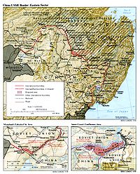
The agreement largely finalized the 4,200 km (2,600 mi) border between the Russian Federation and the People's Republic of China, except for a few disputed areas. The agreement states the intentions of both parties in resolving and demarcating the disputed border peacefully, identifies the various points of contention, and identifies the border as running through the center of the main channel of any river, based on the thalweg principleThalweg
Thalweg in geography and fluvial geomorphology signifies the deepest continuous inline within a valley or watercourse system.-Hydrology:In hydrological and fluvial landforms, the thalweg is a line drawn to join the lowest points along the entire length of a stream bed or valley in its downward...
. The location of the main channel and the possession of the various islands would be decided in the course of the demarcation work. Various other articles stipulate military, usage, and traffic rights along the river borders. Two areas, Heixiazi
Heixiazi
Bolshoi Ussuriysky Island , or Heixiazi Island , is a sedimentary island at the confluence of the Ussuri and Amur rivers. It is divided between the People's Republic of China and Russia...
and Abagaitu Islet
Abagaitu Islet
Abagaitu Islet is an islet in the Argun River divided between the People's Republic of China and Russia...
, were excluded from the agreement, and their status would not be resolved until 2004. According to the estimates by Boris Tkachenko, a Russian historian, the treaty resulted in net territorial gain for China, which received about 720 km², including some seven hundred islands. http://cio.ceu.hu/courses/CIO/modules/Module06Lomanov/Lomanov_06.html
Because islands on the Argun, Amur, and Ussuri rivers often split the rivers into multiple streams, the location of the main stream (and thus the border) was often not immediately apparent. Obviously, each country would receive a greater number of islands if the recognized main channel was closer to the opposite bank. Thus, the demarcation work was often controversial and subject to local protests over disputed territories. The demarcation work continued nearly up until its 1997 deadline.
Disputed territories and their resolution
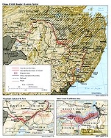
The border territories that were disputed (arranged clockwise):Western border
After the breakup of the Soviet Union, the former Sino-Soviet border was now shared by Tajikistan, Kyrgystan, Kazakhstan, and Russia. While the majority of the disputed territories lay in the west, the Russian Federation inherited only about 50 km (26 mi) of the former western Sino-Soviet border. China negotiated separate border agreements with each of the post-Soviet republics on its western borders.Argun River
413 islands and islets along the river were disputed. The final apportionment has 204 islands in Russian territory and 209 islands in Chinese territory.
Specifically excluded from the agreement was the status of 5 km² (2 mi²) Abagaitu Islet
Abagaitu Islet
Abagaitu Islet is an islet in the Argun River divided between the People's Republic of China and Russia...
, on the border between China's Inner Mongolia
Inner Mongolia
Inner Mongolia is an autonomous region of the People's Republic of China, located in the northern region of the country. Inner Mongolia shares an international border with the countries of Mongolia and the Russian Federation...
and Russia's Chita Oblast
Chita Oblast
Chita Oblast was a federal subject of Russia in southeast Siberia, Russia. Its administrative center was the city of Chita. It had extensive international borders with China and Mongolia and internal borders with Irkutsk and Amur Oblasts, as well as with the Buryat and the Sakha Republics. Its...
and near the cities of Zabaykalsk
Zabaykalsk
Zabaykalsk is an urban locality and the administrative center of Zabaykalsky District of Zabaykalsky Krai, Russia, located on the Russian-Chinese border just opposite the Chinese border town of Manzhouli...
and Manzhouli
Manzhouli
- Administration :Manzhouli is divided into ten subdistricts and one town. Six of the subdistricts of Manzhouli are grouped into a district. Technically however, only a prefecture-level city can have districts, so Manzhouli's lone district is not officially listed.- History :In ancient times the...
. In Chinese it is known by the Mongolian name of Abaigaitui, while the name in Russian is Bolshoy. This island would be transferred to China in subsequent agreements in 2004.
Amur River
The islands of the Amur river were subject to some border clashes between Soviet and Japanese forces during the Manchukuo period. After the invasion of Manchukuo during World War IIWorld War II
World War II, or the Second World War , was a global conflict lasting from 1939 to 1945, involving most of the world's nations—including all of the great powers—eventually forming two opposing military alliances: the Allies and the Axis...
, the Soviet Union unilaterally occupied many of the islands along the Amur River and prevented Chinese locals from entering. These islands were the site of several military skirmishes during the 1960s. Most of the disputed islands have been transferred to China. Of the 1,680 islands along the Amur, the agreement now recognizes 902 Chinese islands and 708 Russian islands.
The two islands of Bolshoy Ussuriysky (32 km²) and Tarabarov island (4 km²) near Khabarovsk
Khabarovsk
Khabarovsk is the largest city and the administrative center of Khabarovsk Krai, Russia. It is located some from the Chinese border. It is the second largest city in the Russian Far East, after Vladivostok. The city became the administrative center of the Far Eastern Federal District of Russia...
, along the junction of the Amur and Ussuri rivers was specifically excluded from the agreement. The two islands are referred to collectively in Chinese as Heixiazi
Heixiazi
Bolshoi Ussuriysky Island , or Heixiazi Island , is a sedimentary island at the confluence of the Ussuri and Amur rivers. It is divided between the People's Republic of China and Russia...
, although the smaller Tarabarov is sometimes called Yinlong. The status of these islands was resolved in 2004, when Tarabarov and approximately 50% of Bolshoy Ussuriysky were transferred to China.
Ussuri River
Of almost 150 island groups on the Ussuri river, almost forty lay disputed. Many of these islands were the site of numerous skirmishes and clashes before and during the Sino-Soviet border conflictSino-Soviet border conflict
The Sino–Soviet border conflict was a seven-month military conflict between the Soviet Union and China at the height of the Sino–Soviet split in 1969. The most serious of these border clashes occurred in March 1969 in the vicinity of Zhenbao Island on the Ussuri River, also known as Damanskii...
. Of the 320 islands along this river, the agreement recognizes 167 Russian islands and 153 Chinese islands.
Kutsuzov is the largest island along the Ussuri. Under former Chinese possession it was known as Daxitong dao. Control was transferred to the Soviet Union during the Manchukuo
Manchukuo
Manchukuo or Manshū-koku was a puppet state in Manchuria and eastern Inner Mongolia, governed under a form of constitutional monarchy. The region was the historical homeland of the Manchus, who founded the Qing Empire in China...
period. Under the terms of the agreement, the island remained in Russia's possession.
Damansky, or Zhenbao Island
Zhenbao Island
Zhenbao Island or Damansky Island is a small island measuring . It is located on the Ussuri River on the border between Russia and the People's Republic of China ....
along the Ussuri River, was the site of the 1969 Damansky Island incident
Sino-Soviet border conflict
The Sino–Soviet border conflict was a seven-month military conflict between the Soviet Union and China at the height of the Sino–Soviet split in 1969. The most serious of these border clashes occurred in March 1969 in the vicinity of Zhenbao Island on the Ussuri River, also known as Damanskii...
. After the conflict, the Chinese appear to have retained de facto control over the island. The agreement recognized China's de jure as well as de facto control.
Lake Khanka
Around 3 km² (1 mi²) of territory at Lake Khanka near the village of Tury Rog was transferred to Chinese control.West of Lake Khanka lay a section of territory unilaterally seized from Manchukuo by the Soviet Union in 1933. This territory, about 0.70 to 0.9 km² (170 to 220 acres), has been transferred to Chinese control.
Suifen River
A delta forms at the junction of the Suifen and Granitnaya Rivers, which is also the location of the border. In 1903, the Russian EmpireRussian Empire
The Russian Empire was a state that existed from 1721 until the Russian Revolution of 1917. It was the successor to the Tsardom of Russia and the predecessor of the Soviet Union...
acquired control of the delta. The delta was later given to Manchukuo, which was then restored to China, but the Soviet Union retained control of the islands along the river. These islands have been transferred to China.
Granitnaya River
This dispute involves a section of the former land border near the Granitnaya River, which borders part of Heilongjiang ProvinceHeilongjiang
For the river known in Mandarin as Heilong Jiang, see Amur River' is a province of the People's Republic of China located in the northeastern part of the country. "Heilongjiang" literally means Black Dragon River, which is the Chinese name for the Amur. The one-character abbreviation is 黑...
and Ussuriysky District (now Ussuriysk
Ussuriysk
Ussuriysk is a city in Primorsky Krai, Russia, located in the fertile valley of the Razdolnaya River, north of Vladivostok and about from both the Chinese border and the Pacific Ocean. Population: -Medieval history:...
urban district) of Primorsky Krai
Primorsky Krai
Primorsky Krai , informally known as Primorye , is a federal subject of Russia . Primorsky means "maritime" in Russian, hence the region is sometimes referred to as Maritime Province or Maritime Territory. Its administrative center is in the city of Vladivostok...
. The original Convention of Peking
Convention of Peking
The Convention of Peking or the First Convention of Peking is the name used for three different unequal treaties, which were concluded between Qing China and the United Kingdom, France, and Russia.-Background:...
(Beijing) states this section of the border lies along the Granitnaya, but the origin of the river de facto lay inside Russian territory. With the 1991 agreement, Russia transferred 9 km² (3.5 mi²) to China so that now the Sino-Russian border runs along the entire length of the river.
Tumen River
The Khasansky District lies near the Sino-North Korean border and the Sino-Russian border and included two disputed regions along the Tumen RiverTumen River
The Tumen River is a 521 km-long river that serves as part of the boundary between China, North Korea, and Russia, rising in Mount Baekdu and flowing into the Sea of Japan....
. According to the agreement, 3 km² (1 mi²) of territory would be transferred to China, and Chinese ships would gain the right to navigate the Tumen river. The territory transfer would connect a previously enclaved piece of Chinese territory to the rest of China. This portion of the agreement stirred up some controversy among some Russian officials from Primorsky Krai, as they felt that direct Chinese access to the Sea of Japan
Sea of Japan
The Sea of Japan is a marginal sea of the western Pacific Ocean, between the Asian mainland, the Japanese archipelago and Sakhalin. It is bordered by Japan, North Korea, Russia and South Korea. Like the Mediterranean Sea, it has almost no tides due to its nearly complete enclosure from the Pacific...
(through the Tumen River) would decrease the economic importance of Vladivostok
Vladivostok
The city is located in the southern extremity of Muravyov-Amursky Peninsula, which is about 30 km long and approximately 12 km wide.The highest point is Mount Kholodilnik, the height of which is 257 m...
and Nakhodka
Nakhodka
Nakhodka is a port city in Primorsky Krai, Russia, situated on the Trudny Peninsula jutting into the Nakhodka Bay of the Sea of Japan, about east of Vladivostok...
. Other arguments protested at potential pollution from Chinese economic development, the possibility of Chinese military vessels navigating the river, and the presence of a Russian cemetery commemorating the Lake Khasan Incident
Battle of Lake Khasan
The Battle of Lake Khasan and also known as the Changkufeng Incident in China and Japan, was an attempted military incursion of Manchukuo into the territory claimed by the Soviet Union...
in the area. Finally, in June 1997, the Russian side proposed a resolution which would divide the disputed territory in half. This was accepted by China in September of the same year, and in November, when the border demarcation work was declared finished, 1.6 km² (0.6 mi²) were transferred to China, and 1.4 km² (0.5 mi²) were retained by Russia. The Lake Khasan cemetery remained on the Russian side, and the Chinese officials underwent informal agreements to not build a port along the Tumen River.
Sino-Russian-North Korean border
The exact location of the Sino-Russian border along the left bank of the Tumen River was an area of contention (the entirety of the right bank of the river belonging to North KoreaNorth Korea
The Democratic People’s Republic of Korea , , is a country in East Asia, occupying the northern half of the Korean Peninsula. Its capital and largest city is Pyongyang. The Korean Demilitarized Zone serves as the buffer zone between North Korea and South Korea...
). The Convention of Peking
Convention of Peking
The Convention of Peking or the First Convention of Peking is the name used for three different unequal treaties, which were concluded between Qing China and the United Kingdom, France, and Russia.-Background:...
(Beijing) set the location of border at 24 km (15 mi) above the mouth of the river, where it enters the Sea of Japan, but through Chinese negotiation was later moved to about 15 or 16 km (9 mi) above the mouth. In 1964, both sides agreed to a border about 17 km (11 mi) above the mouth, and these terms were kept in the 1991 agreement. However, the Russian side preferred it to be set at 24 km, and the Chinese at 15 km. The final position was set at 18.3 km (11.3 mi) above the mouth of the river.
The final position of the triangular border, where the People's Republic of China, Russia, and North Korea meet, was successfully demarcated in 1998 after trilateral negotiations from all three countries, and went into effect 1999.
Relation to Taiwanese mainland claim
The Republic of ChinaRepublic of China
The Republic of China , commonly known as Taiwan , is a unitary sovereign state located in East Asia. Originally based in mainland China, the Republic of China currently governs the island of Taiwan , which forms over 99% of its current territory, as well as Penghu, Kinmen, Matsu and other minor...
now based in Taiwan
Taiwan
Taiwan , also known, especially in the past, as Formosa , is the largest island of the same-named island group of East Asia in the western Pacific Ocean and located off the southeastern coast of mainland China. The island forms over 99% of the current territory of the Republic of China following...
does not recognize any Chinese territorial changes based on any border agreements signed by the People's Republic of China with any other countries, including this 1991 one, due to the requirements in the Constitution of the Republic of China
Constitution of the Republic of China
The Constitution of the Republic of China is the fundamental law of the Republic of China . Drafted by the Kuomintang as part of its third stage of national development , it established a centralized Republic with five branches of government...
and its Additional Articles.
See also
- Sino-Kazakhstan border agreement
- Sino-Kyrgystan border agreement
- Sino-Tajikistan border agreement
- Sino-Soviet border conflictSino-Soviet border conflictThe Sino–Soviet border conflict was a seven-month military conflict between the Soviet Union and China at the height of the Sino–Soviet split in 1969. The most serious of these border clashes occurred in March 1969 in the vicinity of Zhenbao Island on the Ussuri River, also known as Damanskii...
- Foreign relations of the People's Republic of ChinaForeign relations of the People's Republic of ChinaThe foreign relations of the People's Republic of China guides the way in which it interacts with foreign nations. As a great power and emerging superpower, China's foreign policy and strategic thinking is highly influential. China officially states it "unswervingly pursues an independent foreign...
- Foreign relations of the Soviet UnionForeign relations of the Soviet UnionAt its founding, the Soviet Union was considered a pariah by most governments because of its communism, and as such was denied diplomatic recognition by most states...
- Treaty of Good-Neighborliness and Friendly Cooperation
- Bear Island (Amur River)
External links
(Chinese version) - The Epoch TimesThe Epoch Times
The Epoch Times is a multi-language, international media organisation. As a newspaper, the Times has been publishing in Chinese since May 2000. It was founded in 1999 by supporters of the Falun Gong spiritual discipline....
criticism of the treaty