
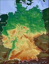
North German plain
Encyclopedia
Germany
Germany , officially the Federal Republic of Germany , is a federal parliamentary republic in Europe. The country consists of 16 states while the capital and largest city is Berlin. Germany covers an area of 357,021 km2 and has a largely temperate seasonal climate...
. It is the German part of the North European Plain. The region is bounded by the coasts of the North Sea
North Sea
In the southwest, beyond the Straits of Dover, the North Sea becomes the English Channel connecting to the Atlantic Ocean. In the east, it connects to the Baltic Sea via the Skagerrak and Kattegat, narrow straits that separate Denmark from Norway and Sweden respectively...
and Baltic Sea
Baltic Sea
The Baltic Sea is a brackish mediterranean sea located in Northern Europe, from 53°N to 66°N latitude and from 20°E to 26°E longitude. It is bounded by the Scandinavian Peninsula, the mainland of Europe, and the Danish islands. It drains into the Kattegat by way of the Øresund, the Great Belt and...
to the north and Germany's Central Uplands
Central Uplands
The Central Uplands is one of the three major natural regions of Germany and covers most of the land area of the country. To the north lies the North German Plain or Northern Lowland; to the south, the Alps and the Alpine Foreland.- Formation :...
(Mittelgebirge
Mittelgebirge
A Mittelgebirge is a relatively low mountain range, a typical geographical feature of Central Europe, especially Central and Southern Germany; it refers to something between hill country and a proper mountain range...
) to the south.
In the west, the southern boundary of the North German Plain is formed by the Lower Saxon Hills
Lower Saxon Hills
The Lower Saxon Hills are one the 73 natural regions in Germany defined by the Federal Agency for Nature Conservation . Geographically it covers roughly the same area as the Weser Uplands in its wider sense....
- specifically the ridge of the Teutoburg Forest
Teutoburg Forest
The Teutoburg Forest is a range of low, forested mountains in the German states of Lower Saxony and North Rhine-Westphalia which used to be believed to be the scene of a decisive battle in AD 9...
, the Wiehen Hills, the Weser Hills and the Lower Saxon Börde - which partly separate it from that area of the Plain known as the Westphalian Lowland
Westphalian Lowland
The Westphalian Lowland, also known as the Westphalian Basin is a flat landscape that mainly lies within the German region of Westphalia, although small areas also fall within North Rhine and in Lower Saxony...
. Elements of the Rhenish Massif also act a part of the southern boundary of the plain: the Eifel
Eifel
The Eifel is a low mountain range in western Germany and eastern Belgium. It occupies parts of southwestern North Rhine-Westphalia, northwestern Rhineland-Palatinate and the south of the German-speaking Community of Belgium....
, Bergisches Land
Bergisches Land
The Bergisches Land is a low mountain range region within the state of Nordrhein-Westfalen, Germany, east of Rhine river, south of the Ruhr. The landscape is shaped by woods, meadows, rivers and creeks and contains over 20 artificial lakes...
and the Sauerland
Sauerland
The Sauerland is a rural, hilly area spreading across most of the south-eastern part of North Rhine-Westphalia, in parts heavily forested and, apart from the major valleys, sparsely inhabited...
. In the east the North German Plain spreads out beyond the Harz mountains and Kyffhäuser
Kyffhäuser
The Kyffhäuser is a range of hills located on the border of the German state of Thuringia with Saxony-Anhalt. It stands on the southern edge of the Harz. The range has a length of and a width of . It reaches its highest point at the Kulpenberg , situated in Thuringia...
further to the south as far as the Central Saxon hill country and the foothills of the Ore Mountains.
Landscape, soils and their formation
It is known that the North German Plain was formed during the PleistocenePleistocene
The Pleistocene is the epoch from 2,588,000 to 11,700 years BP that spans the world's recent period of repeated glaciations. The name pleistocene is derived from the Greek and ....
era as a result of the various glacial
Glacier
A glacier is a large persistent body of ice that forms where the accumulation of snow exceeds its ablation over many years, often centuries. At least 0.1 km² in area and 50 m thick, but often much larger, a glacier slowly deforms and flows due to stresses induced by its weight...
advances of terrestrial Scandinavia
Scandinavia
Scandinavia is a cultural, historical and ethno-linguistic region in northern Europe that includes the three kingdoms of Denmark, Norway and Sweden, characterized by their common ethno-cultural heritage and language. Modern Norway and Sweden proper are situated on the Scandinavian Peninsula,...
n ice sheets as well as by periglacial
Periglacial
Periglacial is an adjective originally referring to places in the edges of glacial areas, but it has later been widely used in geomorphology to describe any place where geomorphic processes related to freezing of water occur...
geomorphologic
Geomorphology
Geomorphology is the scientific study of landforms and the processes that shape them...
processes. The terrain may be considered as part of the Old or Young Drift (Alt- or Jungmoräne), depending on whether or not it was formed by the ice sheets of the last glacial period, the Weichselian Ice Age, The surface relief varies from level to undulating. The lowest points are low moorlands and old marshland on the edge of the ridge of dry land in the west of Schleswig-Holstein (the Wilster Marsh is 3.5 metres below sea level) and in the north west of Lower Saxony (Freepsum, 2.3 metres below sea level). The highest points may be referred to as Vistula and Hall glaciation terminal moraines (depending on the ice age which formed them) – e.g. on the Fläming Heath (200 metres above sea level) and the Helpt Hills
Helpt Hills
The Helpt Hills are the highest natural elevation in the northeast German state of Mecklenburg-Vorpommern reaching a maximum height of above sea level...
(179 metres). Following the ice ages, rain-catching high moor bogs originated in western and northern Lower Saxony during warm periods of high precipitation (cf the Atlantic warm period). These bogs were formerly widespread but much of this terrain has now been drained or otherwise superseded.
The coastal areas consist of Holocene lake and river marshes and lagoons connected to Pleistocene Old and Young Drift terrain in various stages of formation and weathering. After or during the retreat of the glaciers, wind-borne sand often formed dunes, which were later fixed by vegetation. Human intervention caused the emergence of open heath such as the Lüneburg Heath
Lüneburg Heath
The Lüneburg Heath is a large area of heath, geest and woodland in northeastern part of the state of Lower Saxony in northern Germany. It forms part of the hinterland for the cities of Hamburg, Hanover, and Bremen and is named after the town of Lüneburg. Most of the area is a nature reserve...
, and measures such as deforestation and the so-called Plaggenhieb (removal of the topsoil for use as fertiliser elsewhere) caused a wide impoverishment of the soil (Podsol
Podsol
In soil science, podzols are the typical soils of coniferous, or boreal forests. They are also the typical soils of eucalypt forests and heathlands in southern Australia...
) . The most fertile soils are the young marshes (Auen-Vegen) and the Börde areas (Hildesheim Börde, Magdeburg Börde, with their fertile, loess soils). High level bog peat can be found in the poorest soils, e.g. in the Teufelsmoor
Teufelsmoor
The Teufelsmoor is a region of bog and moorland north of Bremen, Germany. It forms a large part of the district of Osterholz, and extends into the neighbouring districts of Rotenburg .- Geography :...
. In the loess areas of the lowland are found the oldest settlement locations in Germany (Linear Pottery culture
Linear Pottery culture
The Linear Pottery culture is a major archaeological horizon of the European Neolithic, flourishing ca. 5500–4500 BC.It is abbreviated as LBK , is also known as the Linear Band Ware, Linear Ware, Linear Ceramics or Incised Ware culture, and falls within the Danubian I culture of V...
).
The north eastern part of the plain (Young Drift) is geomorphologically distinct and contains a multitude of lakes (e.g. the Mueritz lake in the Mecklenburg Lake Plateau) which are vestiges of the last ice age. The retreating glaciers left this landscape behind around 16,000 to 13,000 years ago. In comparison, the dry plains of northwestern Germany (Lower Saxony, western Schleswig-Holstein and the Bochum area of North Rhine Westphalia) are more heavily weathered and levelled (Old Drift) as the last large scale glaciations here occurred at least 130,000 years ago.
The region is drained by rivers that flow northwards into the North Sea
North Sea
In the southwest, beyond the Straits of Dover, the North Sea becomes the English Channel connecting to the Atlantic Ocean. In the east, it connects to the Baltic Sea via the Skagerrak and Kattegat, narrow straits that separate Denmark from Norway and Sweden respectively...
or the Baltic
Baltic Sea
The Baltic Sea is a brackish mediterranean sea located in Northern Europe, from 53°N to 66°N latitude and from 20°E to 26°E longitude. It is bounded by the Scandinavian Peninsula, the mainland of Europe, and the Danish islands. It drains into the Kattegat by way of the Øresund, the Great Belt and...
. The Rhine, Ems, Weser, Elbe
Elbe
The Elbe is one of the major rivers of Central Europe. It rises in the Krkonoše Mountains of the northwestern Czech Republic before traversing much of Bohemia , then Germany and flowing into the North Sea at Cuxhaven, 110 km northwest of Hamburg...
and Havel
Havel
The Havel is a river in north-eastern Germany, flowing through the German states of Mecklenburg-Vorpommern, Brandenburg, Berlin and Saxony-Anhalt. It is a right tributary of the Elbe river and in length...
are the most important rivers which drain the North German Lowlands into the North Sea and created woods in their flood plains and folds, e.g. the Spreewald
Spreewald
The Spreewald is situated about 100 km south-east of Berlin. It was designated a biosphere reserve by UNESCO in 1991. It is known for its traditional irrigation system which consists of more than 200 small channels within the area. The landscape was shaped during the ice-age...
("Spree Forest"). Only a small area of the North German Plain falls within the catchment area of the Oder
Oder
The Oder is a river in Central Europe. It rises in the Czech Republic and flows through western Poland, later forming of the border between Poland and Germany, part of the Oder-Neisse line...
and Neiße rivers which drain into the Baltic.
Climate and vegetation
The North Sea coast and the adjacent coastal areas of the facing EastEast Frisian Islands
The East Frisian Islands are a chain of islands in the North Sea, off the coast of East Frisia in Lower Saxony, Germany. The islands extend for some from west to east between the mouths of the Ems and Jade / Weser rivers and lie about 3.5 to 10 km offshore...
and North Frisian Islands
North Frisian Islands
The North Frisian Islands are a group of islands in the Wadden Sea, a part of the North Sea, off the western coast of Schleswig-Holstein, Germany. The German islands are in the traditional region of North Frisia and are part of the Schleswig-Holstein Wadden Sea National Park and the Kreis of...
are characterised by a maritime climate. South of the coast, a broad band of maritime and sub-maritime climate stretches from the east coast of Schleswig-Holstein
Schleswig-Holstein
Schleswig-Holstein is the northernmost of the sixteen states of Germany, comprising most of the historical duchy of Holstein and the southern part of the former Duchy of Schleswig...
to the western edges of the Central Uplands
Central Uplands
The Central Uplands is one of the three major natural regions of Germany and covers most of the land area of the country. To the north lies the North German Plain or Northern Lowland; to the south, the Alps and the Alpine Foreland.- Formation :...
. To the south east and east, the climate becomes increasingly subcontinental: characterised by temperature differences between summer and winter which progressively increase away from the tempering effect of the ocean. Locally, a drier continental climate
Continental climate
Continental climate is a climate characterized by important annual variation in temperature due to the lack of significant bodies of water nearby...
can be found in the rain shadow
Rain shadow
A rain shadow is a dry area on the lee side of a mountainous area. The mountains block the passage of rain-producing weather systems, casting a "shadow" of dryness behind them. As shown by the diagram to the right, the warm moist air is "pulled" by the prevailing winds over a mountain...
of the Harz
Harz
The Harz is the highest mountain range in northern Germany and its rugged terrain extends across parts of Lower Saxony, Saxony-Anhalt and Thuringia. The name Harz derives from the Middle High German word Hardt or Hart , latinized as Hercynia. The legendary Brocken is the highest summit in the Harz...
and some smaller areas of upland like the Drawehn
Drawehn
The Drawehn is a partly wooded and partly agricultural region of hills in the northeastern part of the German state of Lower Saxony, lying between the districts of Lüneburg and Uelzen in the west and Lüchow-Dannenberg in the east.- Definition :...
and the Fläming
Fläming
The Fläming Heath is a region and a hill chain that reaches over 100 km from the Elbe river to the Dahme River in the German states Saxony-Anhalt and Brandenburg. Its highest elevation is the Hagelberg...
. Special microclimate
Microclimate
A microclimate is a local atmospheric zone where the climate differs from the surrounding area. The term may refer to areas as small as a few square feet or as large as many square miles...
s occur in bog
Bog
A bog, quagmire or mire is a wetland that accumulates acidic peat, a deposit of dead plant material—often mosses or, in Arctic climates, lichens....
s and heathlands
Heath (habitat)
A heath or heathland is a dwarf-shrub habitat found on mainly low quality acidic soils, characterised by open, low growing woody vegetation, often dominated by plants of the Ericaceae. There are some clear differences between heath and moorland...
and, for example, in the Altes Land
Altes Land
Altes Land is an area of reclaimed marshland straddling parts of Lower Saxony and Hamburg. The region is situated downstream from Hamburg on the southwestern riverside of the Elbe around the towns of Stade, Buxtehude, Jork and the Samtgemeinde of Lühe...
near Hamburg
Hamburg
-History:The first historic name for the city was, according to Claudius Ptolemy's reports, Treva.But the city takes its modern name, Hamburg, from the first permanent building on the site, a castle whose construction was ordered by the Emperor Charlemagne in AD 808...
, which is characterised by relatively mild temperatures year round due to the proximity of the North Sea and lower Elbe river, providing excellent conditions for fruit production.
Azonal vegetation complexes of moors, riparian forests, fens and water bodies originally stretched along the rivers Ems, Weser, Elbe
Elbe
The Elbe is one of the major rivers of Central Europe. It rises in the Krkonoše Mountains of the northwestern Czech Republic before traversing much of Bohemia , then Germany and flowing into the North Sea at Cuxhaven, 110 km northwest of Hamburg...
, Havel
Havel
The Havel is a river in north-eastern Germany, flowing through the German states of Mecklenburg-Vorpommern, Brandenburg, Berlin and Saxony-Anhalt. It is a right tributary of the Elbe river and in length...
and Spree
Spree
The Spree is a river that flows through the Saxony, Brandenburg and Berlin states of Germany, and in the Ústí nad Labem region of the Czech Republic...
. Distinctive salt marsh
Salt marsh
A salt marsh is an environment in the upper coastal intertidal zone between land and salt water or brackish water, it is dominated by dense stands of halophytic plants such as herbs, grasses, or low shrubs. These plants are terrestrial in origin and are essential to the stability of the salt marsh...
es, tideflats and tidal reed bed
Reed bed
Reed beds are natural habitats found in floodplains, waterlogged depressions andestuaries. Reed beds are part of a succession from young reed colonising open water or wet ground through a gradation of increasingly dry ground...
s in the estuaries
Estuary
An estuary is a partly enclosed coastal body of water with one or more rivers or streams flowing into it, and with a free connection to the open sea....
existed permanently in the tidal
Tide
Tides are the rise and fall of sea levels caused by the combined effects of the gravitational forces exerted by the moon and the sun and the rotation of the Earth....
zone of the North Sea coast. The natural vegetation of the North German Plain is thought to have been forest formed mainly by the dominant species European Beech
European Beech
Fagus sylvatica, the European Beech or Common Beech, is a deciduous tree belonging to the beech family Fagaceae.-Natural range:...
(Fagetalia).
Natural regions
According to Germany's Federal Agency for Nature Conservation, the BfN, the North German Plain consists of the natural regionNatural region
A Natural region is one which is distinguished by its natural features of geography and usually more important, geology. The natural ecology of the region is likely to be significant but one of these factors tends to influence the others....
s listed below. Where possible, their names have been derived from authoritative English-language source(s), as indicated by the references.
- * D01 Mecklenburg Coastal Lowland
- * D02 Northeast Mecklenburg Lowland (including the Szczecin Lagoon)
- * D03 Mecklenburg Lake Plateau Hinterland
- * D04 Mecklenburg Lake Plateau
- * D05 Mecklenburg-Brandenburg Plateau and Upland
- * D06 East BrandenburgBrandenburgBrandenburg is one of the sixteen federal-states of Germany. It lies in the east of the country and is one of the new federal states that were re-created in 1990 upon the reunification of the former West Germany and East Germany. The capital is Potsdam...
Plateau - * D07 OderOderThe Oder is a river in Central Europe. It rises in the Czech Republic and flows through western Poland, later forming of the border between Poland and Germany, part of the Oder-Neisse line...
Valley - * D08 LusatiaLusatiaLusatia is a historical region in Central Europe. It stretches from the Bóbr and Kwisa rivers in the east to the Elbe valley in the west, today located within the German states of Saxony and Brandenburg as well as in the Lower Silesian and Lubusz voivodeships of western Poland...
n Basin and SpreewaldSpreewaldThe Spreewald is situated about 100 km south-east of Berlin. It was designated a biosphere reserve by UNESCO in 1991. It is known for its traditional irrigation system which consists of more than 200 small channels within the area. The landscape was shaped during the ice-age... - * D09 Middle ElbeElbeThe Elbe is one of the major rivers of Central Europe. It rises in the Krkonoše Mountains of the northwestern Czech Republic before traversing much of Bohemia , then Germany and flowing into the North Sea at Cuxhaven, 110 km northwest of Hamburg...
Plain - * D10 Elbe-MuldeMuldeThe Mulde is a river in Saxony and Saxony-Anhalt, Germany. It is a left tributary of the Elbe and 124 km in length.The river is formed by the confluence, near Colditz, of the Zwickauer Mulde and the Freiberger Mulde , both rising from the Ore Mountains...
Plain - * D11 Fläming Heath
- * D12 Brandenburg Heath and Lake District
- * D13 Upper Lusatian Plateau
- * D14 Upper LusatiaUpper LusatiaUpper Lusatia is a region a biggest part of which belongs to Saxony, a small eastern part belongs to Poland, the northern part to Brandenburg. In Saxony, Upper Lusatia comprises roughly the districts of Bautzen and Görlitz , in Brandenburg the southern part of district Oberspreewald-Lausitz...
- * D21 Schleswig-Holstein Marsch
- * D22 Schleswig-Holstein Geest (older moraines above marsh level)
- * D23 Schleswig-Holstein Upland (more recent moraines)
- * D24 Lower Elbe Marsch
- * D25 Ems and Weser Marsch
- * D26 East Frisian Geest
- * D27 Stade GeestStade GeestThe Stade Geest is a natural region of low, sandy heath in the North German Plain.It includes a large part of the Elbe-Weser Triangle between the cities of Hamburg, Bremen and Cuxhaven and is bordered by the natural regions of the Elbe Marsch, Weser Marsch, Weser-Aller Plain and Lüneburg Heath...
- * D28 Lüneburg HeathLüneburg HeathThe Lüneburg Heath is a large area of heath, geest and woodland in northeastern part of the state of Lower Saxony in northern Germany. It forms part of the hinterland for the cities of Hamburg, Hanover, and Bremen and is named after the town of Lüneburg. Most of the area is a nature reserve...
- * D29 WendlandWendlandWendland may refer to either of the following regions or people:*Wendland may refer to a region once inhabited by Wends, an old Germanic term for Slavic tribes living in close proximity to the Germanic tribes:...
and AltmarkAltmarkThe Altmark is a historic region in Germany, comprising the northern third of Saxony-Anhalt. As the initial territory of the Brandenburg margraves, it is sometimes referred to as the "Cradle of Prussia", as by Otto von Bismarck, a native from Schönhausen near Stendal.- Geography :The Altmark is... - * D30 Dümmer and Ems-Hunte Geest
- * D31 Weser-AllerAllerThe Aller is a river, long, in the states of Saxony-Anhalt and Lower Saxony in Germany. It is a right-hand, and hence eastern, tributary of the River Weser and is also its largest tributary. Its last form the Lower Aller federal waterway...
Plain - * D34 Westphalian LowlandWestphalian LowlandThe Westphalian Lowland, also known as the Westphalian Basin is a flat landscape that mainly lies within the German region of Westphalia, although small areas also fall within North Rhine and in Lower Saxony...
or Basin - * D35 Lower Rhine PlainLower Rhine PlainThe Lower Rhine Plain is one of the natural regions of Germany and lies on either side of the River Rhine north of the city of Düsseldorf.- Geography :...
and Cologne Lowland
Military importance
NATO military strategists identified the North German plain as an area which might be used as one of two major invasion routes into Western EuropeWestern Europe
Western Europe is a loose term for the collection of countries in the western most region of the European continents, though this definition is context-dependent and carries cultural and political connotations. One definition describes Western Europe as a geographic entity—the region lying in the...
by Warsaw Pact
Warsaw Pact
The Warsaw Treaty Organization of Friendship, Cooperation, and Mutual Assistance , or more commonly referred to as the Warsaw Pact, was a mutual defense treaty subscribed to by eight communist states in Eastern Europe...
forces, led by the Soviet
Soviet Union
The Soviet Union , officially the Union of Soviet Socialist Republics , was a constitutionally socialist state that existed in Eurasia between 1922 and 1991....
Third Shock Army
3rd Shock Army (Soviet Union)
The 3rd Shock Army was a field army of the Red Army formed during the Second World War. The 'Shock' armies were created with the specific structure to engage and destroy significant enemy forces, and were reinforced with more armoured and artillery assets than other combined arms armies...
, should the Cold War
Cold War
The Cold War was the continuing state from roughly 1946 to 1991 of political conflict, military tension, proxy wars, and economic competition between the Communist World—primarily the Soviet Union and its satellite states and allies—and the powers of the Western world, primarily the United States...
ever get "hot". The plain's geography which makes it suitable for the deployment of armoured and mechanized
Mechanized infantry
Mechanized infantry are infantry equipped with armored personnel carriers , or infantry fighting vehicles for transport and combat ....
manoeuvre
Maneuver warfare
Maneuver warfare, or manoeuvre warfare , is the term used by military theorists for a concept of warfare that advocates attempting to defeat an adversary by incapacitating their decision-making through shock and disruption brought about by movement...
, was the main reason for it being identified as a significant risk similar to that presented by the alternative route, the Fulda Gap
Fulda Gap
The Fulda Gap is a region of lower elevation between the former East German border and Frankfurt am Main, Germany. Named for the town of Fulda, the Fulda Gap was strategically important during the Cold War...
. The defence of the Plain was the responsibility of US, German, Dutch, Belgian and British forces including 1st British Corps.
External links
- The North German Lowland
- "North German Plain", Britannica Online Encyclopedia
- Federal (German) Statistical Office - Geography and climate
- Germany's Geography