
Lower Saxon Hills
Encyclopedia
The Lower Saxon Hills are one the 73 natural region
s in Germany defined by the Federal Agency for Nature Conservation
(BfN). Geographically it covers roughly the same area as the Weser Uplands in its wider sense.
The region is part of Germany's Central Uplands
with hills ranging up to in height that extend across northeast North Rhine-Westphalia
, southern Lower Saxony
and northern Hesse
. It is classified as region number D 36 by the BfN; its full name being the Niedersächsisches Bergland (mit Weser- und Leine-Bergland (Lower Saxon Hills, including the Weser and Leine Hills).
D 36 is a newly-defined region that incorporates 3 geographical units from the old system: numbers 36, 37 and 53, and includes all parts of the Weser Uplands (Weserbergland) in both its narrower and a wider sense. That said, all three elements of the region, despite their misleading names, cover far more than is generally meant in everyday language or in atlases by the term Weserbergland.
In addition the Weser-Leine Hills sub-division (37) includes the whole of the Leine Uplands
(Leinebergland), whilst the Harz
mountains, admittedly are only partly in Lower Saxony, are clearly older in geological time scale and have been given their own natural region (D37) rather than being grouped with the lower Saxon Hills.
Those regions which are normally considered part of the Weser Uplands in its narrower sense are indicated by (W); similarly the which are normally included in the Leine Uplands
are annotated with (L):
| width="325" valign="top" |
In addition to the Osning (=Teutoburg Forest
) and the Wiehen Hills, historic landscapes like the Tecklenburger Land und Osnabrücker Land are also part of this region.
| width="325" valign="top" |
The Weser Valley between Bad Karlshafen
and Porta Westfalica
also belongs to this area.>
| width="250" valign="top" |
| width="250" valign="top" |
| width="250" valign="top" |
Natural region
A Natural region is one which is distinguished by its natural features of geography and usually more important, geology. The natural ecology of the region is likely to be significant but one of these factors tends to influence the others....
s in Germany defined by the Federal Agency for Nature Conservation
Federal Agency for Nature Conservation
The German Federal Agency for Nature Conservation is the German government’s scientific authority with responsibility for national and international nature conservation...
(BfN). Geographically it covers roughly the same area as the Weser Uplands in its wider sense.
The region is part of Germany's Central Uplands
Central Uplands
The Central Uplands is one of the three major natural regions of Germany and covers most of the land area of the country. To the north lies the North German Plain or Northern Lowland; to the south, the Alps and the Alpine Foreland.- Formation :...
with hills ranging up to in height that extend across northeast North Rhine-Westphalia
North Rhine-Westphalia
North Rhine-Westphalia is the most populous state of Germany, with four of the country's ten largest cities. The state was formed in 1946 as a merger of the northern Rhineland and Westphalia, both formerly part of Prussia. Its capital is Düsseldorf. The state is currently run by a coalition of the...
, southern Lower Saxony
Lower Saxony
Lower Saxony is a German state situated in north-western Germany and is second in area and fourth in population among the sixteen states of Germany...
and northern Hesse
Hesse
Hesse or Hessia is both a cultural region of Germany and the name of an individual German state.* The cultural region of Hesse includes both the State of Hesse and the area known as Rhenish Hesse in the neighbouring Rhineland-Palatinate state...
. It is classified as region number D 36 by the BfN; its full name being the Niedersächsisches Bergland (mit Weser- und Leine-Bergland (Lower Saxon Hills, including the Weser and Leine Hills).
D 36 is a newly-defined region that incorporates 3 geographical units from the old system: numbers 36, 37 and 53, and includes all parts of the Weser Uplands (Weserbergland) in both its narrower and a wider sense. That said, all three elements of the region, despite their misleading names, cover far more than is generally meant in everyday language or in atlases by the term Weserbergland.
In addition the Weser-Leine Hills sub-division (37) includes the whole of the Leine Uplands
Leine Uplands
The Leine Uplands is a region in Germany's Central Uplands which forms a part of the Lower Saxon Hills and lies along the River Leine between Göttingen and Hanover...
(Leinebergland), whilst the Harz
Harz
The Harz is the highest mountain range in northern Germany and its rugged terrain extends across parts of Lower Saxony, Saxony-Anhalt and Thuringia. The name Harz derives from the Middle High German word Hardt or Hart , latinized as Hercynia. The legendary Brocken is the highest summit in the Harz...
mountains, admittedly are only partly in Lower Saxony, are clearly older in geological time scale and have been given their own natural region (D37) rather than being grouped with the lower Saxon Hills.
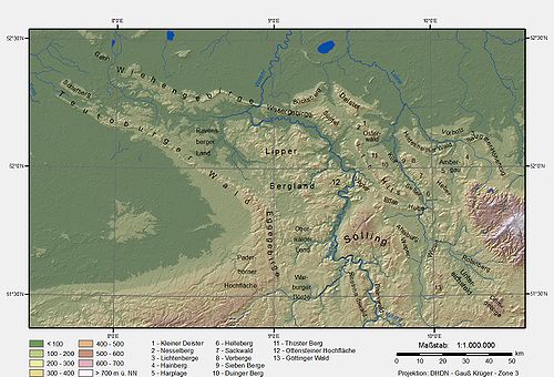
Natural divisions
The following tables show the landscape sub-divisions in the Lower Saxon Hills.Those regions which are normally considered part of the Weser Uplands in its narrower sense are indicated by (W); similarly the which are normally included in the Leine Uplands
Leine Uplands
The Leine Uplands is a region in Germany's Central Uplands which forms a part of the Lower Saxon Hills and lies along the River Leine between Göttingen and Hanover...
are annotated with (L):
- 53 Lower Weser Uplands
- 530 Bielefeld Osning
- 531 Ravensberg Hills
- 532 Eastern Wiehen Hills (W)
- 533 Lübbecke LoesslandLübbecke LoesslandThe Lübbecke Loessland is a natural region that is mainly situated in northeastern North Rhine-Westphalia but with a small area also lying in the western part of Lower Saxony in Germany. It is a belt of land, covered by loess, about 2 to 5 km wide and around 35 km long, that lies just north of the...
- 534 Tecklenburg Osning
- 535 Osnabrück Hills (including the GehnGehnThe Gehn is a small ridge of hills between Bramsche and Ueffeln in Germany's Central Uplands, that are an extension of the Wiehen Hills .The ridge runs from northwest to southeast and is about long and an average of wide. The highest point is the Kettelberg which is high. The Gehn forms a link...
) - 536 Western Wiehen Hills
In addition to the Osning (=Teutoburg Forest
Teutoburg Forest
The Teutoburg Forest is a range of low, forested mountains in the German states of Lower Saxony and North Rhine-Westphalia which used to be believed to be the scene of a decisive battle in AD 9...
) and the Wiehen Hills, historic landscapes like the Tecklenburger Land und Osnabrücker Land are also part of this region.
| width="325" valign="top" |
- 36 Upper Weser Uplands
- 360 Warburg Börde
- 361 Oberwälder LandOberwälder LandThe Oberwälder Land is a natural region in the extreme east of the German state of North Rhine-Westphalia with small elements parts in Hesse and Lower Saxony...
including NethegauNethegauThe Nethegau is a region in central Germany named after the river Nethe and covers, in the main, the Brakel Upland between the River Weser and the Eggegebirge ridge around the towns of Brakel and Bad Driburg in the district of Höxter in North Rhine-Westphalia.The region was formerly a Saxon Gau... - 362 Paderborn PlateauPaderborn PlateauThe Paderborn Plateau in central Germany is, geologically speaking, the southeastern element of the Westphalian Bight and, at the same time, the largest limestone and karst landscape in Westphalia....
- 363 EggeEggegebirgeThe Eggegebirge is a range of low, forested mountains in the very east of the German state of North Rhine-Westphalia.-Geography:The Eggegebirge extends from the southern tip of the Teutoburger Wald range near Horn-Bad Meinberg southwards to the northern parts of the Sauerland near Marsberg...
- 364 Lippe UplandsLippe UplandsThe Lippe Uplands is a range of hills in Ostwestfalen-Lippe within the administrative district of Detmold in the German state of North Rhine-Westphalia.-Geography:...
- 365 Pyrmont Uplands
- Ottenstein PlateauOttenstein PlateauThe Ottenstein Plateau is part of the Lower Saxon Weser Uplands and lies between Bodenwerder and Bad Pyrmont.Compared with the surrounding area of the Weser and Emmer valleys, the plateau is a largely open plain, about 200 m higher, and which lies between 250 and 350 metres above sea level...
(W)
- Ottenstein Plateau
- 366 Rinteln-Hameln Weserland (W)
- 367 Holzminden Weser Valley (W)
- 368 Weser Gorge of Bodenwerder (W)
The Weser Valley between Bad Karlshafen
Bad Karlshafen
Bad Karlshafen is a baroque, thermal salt spa town in the district of Kassel, in Hesse, Germany. It has 2300 inhabitants in the main ward of Bad Karlshafen, and a further 1900 in the medieval ward of Helmarshausen...
and Porta Westfalica
Porta Westfalica
Porta Westfalica is a town in the district of Minden-Lübbecke, in North Rhine-Westphalia, Germany. The name “Porta Westfalica” is Latin and means “gate to Westphalia”. Coming from the north, the gorge is the entry to the region of Westphalia...
also belongs to this area.>
- 37 Weser-Leine Uplands
| width="250" valign="top" |
-
- 370 SollingSollingThe Solling is a range of hills up to high in the Weser Uplands in the German state of Lower Saxony, whose extreme southerly foothills extend into Hesse and North Rhine-Westphalia....
(W), BramwaldBramwaldThe Bramwald is a range of hills up to in the Weser Uplands in Lower Saxony . It is a unique, natural, wild, hill and forest landscape...
(W) and ReinhardswaldReinhardswaldThe Reinhardswald is a range of hills up to and covering an area of over 200 km² in the Weser Uplands in the district of Kassel, Hesse...
(W) - 371 Solling Foreland
- VoglerVoglerThe Vogler is a range of hills, up to 460.4 m high, in the Weser Uplands in southern Lower Saxony .Together with the Solling, the Vogler forms the Solling-Vogler Nature Park which lies a couple of kilometres further south.- Geography :...
(W) - ElfasElfasThe Elfas is a range of hills up to in the districts of Holzminden an Northeim in Lower Saxony .- Geographical location :The Elfas is located in the middle of the Leine Uplands between the Hils to the north, the Homburg Forest to the west, the Hube to the east, the Amtsberge to the south-southwest...
(L) - AhlsburgAhlsburgThe Ahlsburg is a range of hills, relatively small in area and up to , in the southern part of Lower Saxony .- Geography :The Ahlsburg hills run in a northwest to southeast direction and are around 10 km long and up to about 3 km wide. They are heavily wooded and belong to the Leine Uplands...
(L) - WeperWeperThe Weper is a long, high ridge of hills up to located in the district of Northeim in the German state of Lower Saxony.Part of the Weper is a nature reserve with the same name which, with an area of , is the large protected region of dry grassland in Lower Saxony.- Geography :The Weper, which lies...
(L)
- Vogler
- 372 Leine-Ilme Basin (L)
- 373 Göttingen-Northeim Forest (L)
- Wieter
- Göttingen ForestGöttingen ForestThe Göttingen Forest is a ridge in Germany's Central Uplands that is up to 427.5 metres high. It forms part of the Lower Saxon Hills in South Lower Saxony.- Geography :...
- 374 Eichsfelder Basin (Goldene Mark)
- RotenbergRotenberg (hills)The Rotenberg is a hill range, up to 317.3 m high, in the Lower Saxon Hills in southeastern Lower Saxony, Germany.- Geography :The Rotenberg ridge is oriented northwest-southeast and measures about 14 kilometres long by 2 kilometres wide. It lies on the boundary of the districts of...
- Goldene Mark
- Rotenberg
- 375 Lower Eichsfeld
- Ohm Hills
- Bleicheröde Hills
- 370 Solling
| width="250" valign="top" |
-
- 376 Southwest Harz Foreland
- Hube (L)
- 377 Alfeld Uplands (Ith-Hils ridges) (L)
- IthIthThe Ith is a ridge in Germany's Central Uplands which is up to high. It lies about 40 km southwest of Hanover and, at 22 kilometres, is the longest line of crags in North Germany.- Geography :- Location :...
(L) - Thüster BergThüster BergThe Thüster Berg is a ridge, up to , in the Lower Saxon Hills in central Germany. It is situated in the districts of Hameln-Pyrmont and Hildesheim in the federal state of Lower Saxony.- Location :...
(L) - KülfKülfThe Külf is a ridge, up to , in the Leine Uplands in the district of Hildesheim in the German state of Lower Saxony.- Location :With seven main summits, the Külf stretches for about 9 kilometres, lying in a triangle formed by the settlements of Gronau, Alfeld and Duingen...
(L) - Sieben BergeSieben BergeThe Sieben Berge are a ridge of hills up to in the Lower Saxon Hills in the district of Hildesheim, Lower Saxony . Together with the Vorberge and the Sackwald the Sieben Berge belong to the geological formation of the Sackmulde....
(L) - VorbergeVorbergeThe Vorberge are a ridge, up to high, in the Lower Saxon Hills and within the district of Hildesheim in the German state of Lower Saxony....
(L) - Duinger BergDuinger BergThe Duinger Berg is a hill range, up to , in the Lower Saxon Hills and the district of Landkreis in the German state of Lower Saxony.- Location :...
(L) - SackwaldSackwaldThe Sackwald is a ridge, up to high, in the Lower Saxon Hills in the district of Hildesheim in the North German state of Lower Saxony. It is named after the village of Sack in the borough of Alfeld, the name meaning "Sack Forest"....
(L) - HilsHilsFor HILS, see Hardware-in-the-loop simulation.The Hils is a range of hills in Germany's Central Uplands that is up to high. It is located in the districts of Holzminden, Hildesheim and Northeim, in the state of Lower Saxony.- Geography :...
(L) - Rettberg (L)
- ReubergReubergThe Reuberg is a ridge, up to , in the Lower Saxon Hills in the districts of Holzminden and Hildesheim in the German state of Lower Saxony.- Location :The Reuberg lies in the western part of the Leine Uplands, a northern section of the Lower Saxon Hills...
(L) - Steinberg (L)
- Selter (L)
- Helleberg (L)
- Ith
- 376 Southwest Harz Foreland
| width="250" valign="top" |
-
- 378 Calenberg UplandsCalenberg UplandsThe Calenberg Uplands are a landscape unit in the Weser-Leine Uplands in Lower Saxony, Germany. They border on the Calenberg Land to the north and merge into the Weser Uplands in the west and the Leine Uplands in the east...
- BückebergBückebergThe Bückeberg is a ridge in the Calenberg Uplands between the Harrl and the Deister in central Germany, and is often considered part of the Weser Uplands...
- DeisterDeisterThe Deister is a chain of hills in the German state of Lower Saxony, about 15 mi southwest of the city of Hanover. It runs in a north-westerly direction from Springe in the south to Rodenberg in the north. The next the chain of hills that attaches in the south is called Small Deister...
- Harrl
- Kleiner DeisterKleiner DeisterThe Kleiner Deister is a ridge of hills in the Calenberg Uplands which, together with the Nesselberg and the Osterwald, forms a group of three adjacent hill ranges in the northern part of the Leine Uplands...
- NesselbergNesselbergThe Nesselberg is a ridge up to high in the Calenberg Highland which, together with the Kleiner Deister and the Osterwald, forms a group of three contiguous hill regions in the northwestern part of the Leine Uplands...
- OsterwaldOsterwaldOsterwald is a community and part of the Joint Community of Neuenhaus in the district of Grafschaft Bentheim in Lower Saxony. The community consists of the centres of Osterwald, Alte Piccardie and Hohenkörben ....
- SüntelSüntelThe Süntel is a massif in the German Central Uplands that is up to . It forms part of the Weser Uplands in Lower Saxony southwest of Hanover and north of Hamelin.-Geographical location:...
(W) - WesergebirgeWesergebirgeThe Wesergebirge is a low mountain chain up to high in the Weser Uplands in the German states of North Rhine-Westphalia and Lower Saxony....
(W)
- Bückeberg
- 379 Innerste UplandsInnerste UplandsThe Innerste Uplands is a landscape region up to 359 m high and covering an area of over 900 km² in the northern part of the German Central Uplands...
- Hildesheim ForestHildesheim ForestThe Hildesheim Forest is a range of hills up to in the district of Hildesheim in the German state of Lower Saxony.- Geography :The Hildesheim Forest is located in the Innerste Uplands, part of the Lower Saxon Hills, between the valleys of the Leine to the west, the Innerste to the north and the ...
- VorholzVorholzThe Vorholz is a ridge up to 243 m high in the districts of Hildesheim and Wolfenbüttel in the German state of Lower Saxony.- Geography :The heavily-wooded Vorholz is located in the north of the Innerste Uplands, part of the Lower Saxon Hills...
- Salzgitter Ridge
- Lichtenberge
- Hainberg
- Ambergau
- HarplageHarplageThe Harplage is a hill range, up to 290 metres high, located west-northwest of the Harz in the southeast of the German state of Lower Saxony.- Geography :...
- HeberHeberHeber may be:-Religious traditions:*One of the Minor characters in the Book of Genesis*Heber the Kenite, mentioned in the Book of Judges 4:17 of the Hebrew Bible as Jael's husband...
>
- Hildesheim Forest
- 378 Calenberg Uplands