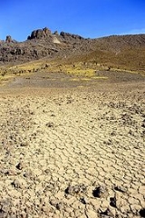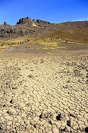
Periglacial
Encyclopedia

Glacier
A glacier is a large persistent body of ice that forms where the accumulation of snow exceeds its ablation over many years, often centuries. At least 0.1 km² in area and 50 m thick, but often much larger, a glacier slowly deforms and flows due to stresses induced by its weight...
areas, but it has later been widely used in geomorphology
Geomorphology
Geomorphology is the scientific study of landforms and the processes that shape them...
to describe any place where geomorphic processes related to freezing of water occur. In the original meaning of periglacial area, areas described by the term were not buried by glacial ice, but were subject to intense freezing cycles and exhibit permafrost weathering and erosion characteristics.
A periglacial lake
Lake
A lake is a body of relatively still fresh or salt water of considerable size, localized in a basin, that is surrounded by land. Lakes are inland and not part of the ocean and therefore are distinct from lagoons, and are larger and deeper than ponds. Lakes can be contrasted with rivers or streams,...
is one formed where the natural drainage of the topography
Topography
Topography is the study of Earth's surface shape and features or those ofplanets, moons, and asteroids...
is obstructed by an ice sheet
Ice sheet
An ice sheet is a mass of glacier ice that covers surrounding terrain and is greater than 50,000 km² , thus also known as continental glacier...
, ice cap
Ice cap
An ice cap is an ice mass that covers less than 50 000 km² of land area . Masses of ice covering more than 50 000 km² are termed an ice sheet....
or glacier
Glacier
A glacier is a large persistent body of ice that forms where the accumulation of snow exceeds its ablation over many years, often centuries. At least 0.1 km² in area and 50 m thick, but often much larger, a glacier slowly deforms and flows due to stresses induced by its weight...
. Periglacial lakes are not typical of areas under the modern Periglacial definition, since most of them formed temporarily during the last deglaciation and are not necessarily associated to landforms created by the freezing of water (glaciers not accounted).
A common ecological community
Biocoenosis
A biocoenosis , coined by Karl Möbius in 1877, describes the interacting organisms living together in a habitat . This term is rarely used in English, as this concept has not been popularized in Anglophone countries...
in periglacial areas is the tundra
Tundra
In physical geography, tundra is a biome where the tree growth is hindered by low temperatures and short growing seasons. The term tundra comes through Russian тундра from the Kildin Sami word tūndâr "uplands," "treeless mountain tract." There are three types of tundra: Arctic tundra, alpine...
.
Extent of periglaciation
Some earth scientists have likened the extent of periglaciation to that of permafrost. Under this definition large areas in SiberiaSiberia
Siberia is an extensive region constituting almost all of Northern Asia. Comprising the central and eastern portion of the Russian Federation, it was part of the Soviet Union from its beginning, as its predecessor states, the Tsardom of Russia and the Russian Empire, conquered it during the 16th...
, Canada
Canada
Canada is a North American country consisting of ten provinces and three territories. Located in the northern part of the continent, it extends from the Atlantic Ocean in the east to the Pacific Ocean in the west, and northward into the Arctic Ocean...
and Alaska
Alaska
Alaska is the largest state in the United States by area. It is situated in the northwest extremity of the North American continent, with Canada to the east, the Arctic Ocean to the north, and the Pacific Ocean to the west and south, with Russia further west across the Bering Strait...
and smaller areas in Fennoscandia
Fennoscandia
Fennoscandia and Fenno-Scandinavia are geographic and geological terms used to describe the Scandinavian Peninsula, the Kola Peninsula, Karelia and Finland...
, Tibet
Tibet
Tibet is a plateau region in Asia, north-east of the Himalayas. It is the traditional homeland of the Tibetan people as well as some other ethnic groups such as Monpas, Qiang, and Lhobas, and is now also inhabited by considerable numbers of Han and Hui people...
, Iceland
Iceland
Iceland , described as the Republic of Iceland, is a Nordic and European island country in the North Atlantic Ocean, on the Mid-Atlantic Ridge. Iceland also refers to the main island of the country, which contains almost all the population and almost all the land area. The country has a population...
, Greenland
Greenland
Greenland is an autonomous country within the Kingdom of Denmark, located between the Arctic and Atlantic Oceans, east of the Canadian Arctic Archipelago. Though physiographically a part of the continent of North America, Greenland has been politically and culturally associated with Europe for...
, Antarctica and the Andes
Andes
The Andes is the world's longest continental mountain range. It is a continual range of highlands along the western coast of South America. This range is about long, about to wide , and of an average height of about .Along its length, the Andes is split into several ranges, which are separated...
are periglaciated. Not all scientists agree with this definition as many areas without permafrost show significant action of processes related to the freezing of water.
Periglaciation is the corresponding noun. It means 'periglacial conditions', that is principally, an area of permafrost
Permafrost
In geology, permafrost, cryotic soil or permafrost soil is soil at or below the freezing point of water for two or more years. Ice is not always present, as may be in the case of nonporous bedrock, but it frequently occurs and it may be in amounts exceeding the potential hydraulic saturation of...
- intense freezing, perhaps with freeze/thaw of the surface. That is to say, the surface layer melts briefly in summer. Periglaciation occurs near mountain glaciers. At lower levels it forms a zone of cold around continental glaciers in areas of high latitudes, covering perhaps 20% of the earth’s land surface.
Periglacial conditions in the Pleistocene
Pleistocene
The Pleistocene is the epoch from 2,588,000 to 11,700 years BP that spans the world's recent period of repeated glaciations. The name pleistocene is derived from the Greek and ....
created landscapes and geological
Geology
Geology is the science comprising the study of solid Earth, the rocks of which it is composed, and the processes by which it evolves. Geology gives insight into the history of the Earth, as it provides the primary evidence for plate tectonics, the evolutionary history of life, and past climates...
conditions moulded by frost action; the repeated freezing and thawing of material over many years. Around a third of the Earth's land surface can be considered as having been subject to periglacial conditions at some time.
Factors affecting location
- Latitude – temperatures tend to be higher towards the equator. Periglacial environments tend to be found in higher latitudeLatitudeIn geography, the latitude of a location on the Earth is the angular distance of that location south or north of the Equator. The latitude is an angle, and is usually measured in degrees . The equator has a latitude of 0°, the North pole has a latitude of 90° north , and the South pole has a...
s. Since there is more land at these latitudes in the north, most of this effect is seen in the northern hemisphere. However, in lower latitudes, the direct effect of the sun's radiation is greater so the freeze-thaw effect is seen but permafrost is much less widespread. - Altitude – Air temperature drops by approximately 1 °C for every 100 m rise above sea level. This means that on mountain ranges, modern periglacial conditions are found nearer the EquatorEquatorAn equator is the intersection of a sphere's surface with the plane perpendicular to the sphere's axis of rotation and containing the sphere's center of mass....
than they are lower down. - Ocean Currents – Cold surface currents from polar regions, reduce mean average temperatures in places where they exert their effect so that ice caps and periglacial conditions will show nearer to the Equator as in LabradorLabradorLabrador is the distinct, northerly region of the Canadian province of Newfoundland and Labrador. It comprises the mainland portion of the province, separated from the island of Newfoundland by the Strait of Belle Isle...
for example. Conversely, warm surface currents from tropical seas increases mean temperatures. The cold conditions are then found only in more northerly places. This is apparent in western North America which is affected by the North Pacific current. In the same way but more markedly, the Gulf Stream affects Western Europe. - Continentality – Away from the moderating influence of the ocean, seasonal temperature variation is more extreme and freeze-thaw goes deeper. In the centres of Canada and Siberia, the permafrost typical of periglaciation goes deeper and extends further towards the Equator. Similarly, solifluction associated with freeze-thaw extends into somewhat lower latitudes than on western coasts.
Landforms associated with periglacial environments

Periglaciation results in a variety of ground conditions but especially those involving irregular, mixed deposits created by ice wedge
Ice wedge
An ice wedge is a crack in the ground formed by a narrow or thin piece of ice that measures up to 3-4 metres wide at ground level and extends downwards into the ground up to several metres. During the winter months, the water in the ground freezes and expands...
s, solifluction
Solifluction
In geology, solifluction, also known as soil fluction, is a type of mass wasting where waterlogged sediment moves slowly downslope, over impermeable material. It occurs in periglacial environments where melting during the warm season leads to water saturation in the thawed surface material ,...
, gelifluction
Gelifluction
Gelifluction, very similar to solifluction, describes the seasonal freeze-thaw action upon waterlogging topsoils which induces downslope movement. Gelifluction is prominent in periglacial regions where snow falls during six to eight months of the year...
, frost creep and rockfall
Rockfall
Rockfall or rock-fall refers to quantities of rock falling freely from a cliff face. A rockfall is a fragment of rock detached by sliding, toppling, or falling, that falls along a vertical or sub-vertical cliff, proceeds down slope by bouncing and flying along ballistic trajectories or by rolling...
s. Periglacial environment are from a geomorphological point view relatively stable, and difficult to alter because all the work done on it has make it insensitive, by having for example low slope angles.
Coombe and head deposits
Coombe deposits are chalk deposits found below chalk escarpments in Southern England. Head deposits are more common below outcrops of granite on Dartmoor
Dartmoor
Dartmoor is an area of moorland in south Devon, England. Protected by National Park status, it covers .The granite upland dates from the Carboniferous period of geological history. The moorland is capped with many exposed granite hilltops known as tors, providing habitats for Dartmoor wildlife. The...
.
Patterned Ground
Patterned ground
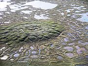
Patterned ground is a term used to describe the distinct, and often symmetrical geometric shapes formed by ground material in periglacial regions...
is stones which form circles, polygons and stripes. Local topography affects which of these are expressed. A process called frost heaving
Frost heaving
Frost heaving results from ice forming beneath the surface of soil during freezing conditions in the atmosphere. The ice grows in the direction of heat loss , starting at the freezing front or boundary in the soil...
is responsible for these features.
Solifluction lobes are formed when waterlogged soil slips down a slope due to gravity forming U shaped lobes.
Blockfield
Blockfield
A blockfield or felsenmeer is a surface covered by block-sized angular rocks usually associated alpine and subpolar climates and periglaciation...
s or Felsenmeer are areas covered by large angular blocks, traditionally believed to have been created by freeze-thaw action. A good example of a blockfield can be found in the Snowdonia National Park, Wales. Blockfields are common in the unglaciated parts of the Appalachian Mountains in the northeastern United States, such as at the River of Rocks
Hawk Mountain
Hawk Mountain is a mountain ridge, part of the Blue Mountain Ridge in the Appalachian Mountain chain, located in central-eastern Pennsylvania near Reading and Allentown. The area includes 13,000 acres of protected private and public land, including the 2,600 acre Hawk Mountain Sanctuary.The River...
or Hickory Run Boulder Field
Hickory Run State Park
Hickory Run State Park is a Pennsylvania state park in Kidder and Penn Forest Townships in Carbon County, Pennsylvania in the United States. The park is spread across the Pocono Mountains...
, Lehigh County
Lehigh County, Pennsylvania
-Climate:Most of the county's climate is considered to fall in the humid continental climate zone. Summers are typically hot and muggy, fall and spring are generally mild, and winter is cold. Precipitation is almost uniformly distributed throughout the year....
, Pennsylvania
Pennsylvania
The Commonwealth of Pennsylvania is a U.S. state that is located in the Northeastern and Mid-Atlantic regions of the United States. The state borders Delaware and Maryland to the south, West Virginia to the southwest, Ohio to the west, New York and Ontario, Canada, to the north, and New Jersey to...
.
Other landforms include:
- PalsaPalsathumb|right|300px|A group of well developed palsas as seen from abovePalsas are low, often oval, frost heaves occurring in polar and subpolar climates, which contain permanently frozen ice lenses...
- PingoPingoA pingo, also called a hydrolaccolith, is a mound of earth-covered ice found in the Arctic and subarctic that can reach up to in height and up to in diameter. The term originated as the Inuvialuktun word for a small hill. A pingo is a periglacial landform, which is defined as a nonglacial...
- RockglacierRock glacierRock glaciers are distinctive geomorphological landforms of angular rock debris frozen in interstitial ice which may extend outward and downslope from talus cones, glaciers or terminal moraines of glaciers. There are two types of rock glaciers: periglacial glaciers, or talus-derived glaciers, and...
- ThermokarstThermokarstThermokarst is a land surface characterised by very irregular surfaces of marshy hollows and small hummocks formed as ice-rich permafrost thaws, that occurs in Arctic areas, and on a smaller scale in mountainous areas such as the Himalayas and the Swiss Alps...
- LoessLoessLoess is an aeolian sediment formed by the accumulation of wind-blown silt, typically in the 20–50 micrometre size range, twenty percent or less clay and the balance equal parts sand and silt that are loosely cemented by calcium carbonate...
River activity
Most areas under periglaciation have relatively low precipitation (if not the areas would likely be glaciated) and low evapotranspirationEvapotranspiration
Evapotranspiration is a term used to describe the sum of evaporation and plant transpiration from the Earth's land surface to atmosphere. Evaporation accounts for the movement of water to the air from sources such as the soil, canopy interception, and waterbodies...
. which makes average river discharge rates low. Many rivers flowing into the Arctic sea of northern Canada and Siberia have despite this a very strong erosive
Erosion
Erosion is when materials are removed from the surface and changed into something else. It only works by hydraulic actions and transport of solids in the natural environment, and leads to the deposition of these materials elsewhere...
capacity due to the fact that thaw occurs first in the upper part of the drainage basin
Drainage basin
A drainage basin is an extent or an area of land where surface water from rain and melting snow or ice converges to a single point, usually the exit of the basin, where the waters join another waterbody, such as a river, lake, reservoir, estuary, wetland, sea, or ocean...
leading to large areas being flooded further down (north) because of obstructing river ice. When these dams melt or break large amounts of water are released with destructive and erosive power.

