

New York State Route 268
Encyclopedia
New York State Route 268 (NY 268) is a state highway
located in southwestern Delaware County
, New York
in the United States
. It runs from NY 97
in Hancock
north over 10 miles (16 km) to a bridge over Cannonsville Reservoir
near the former site of the hamlet of Rock Rift in Tompkins
. There, it ends at a junction with NY 10
. NY 268 meets the Quickway (NY 17
) east of the Hancock village limits.
From Hancock to the NY 17 interchange, NY 268 follows the pre-Quickway routing of NY 17. Between NY 17 and NY 10, the route follows the former alignment of New York State Route 236, a connector between then-NY 17 and NY 10 that existed during the 1930s. In the floods of 2006
some of the areas along this rural highway suffered serious landslide
s, leading to a temporary closure of the road.
 NY 268 begins at an intersection with NY 97
in eastern Hancock
. The route heads northeast, paralleling the Quickway (NY 17
) and following the east branch of the Delaware River
's northern bank through the town of Hancock
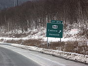
toward the hamlet of Cadosia. South of the hamlet, NY 268 connects to NY 17 at exit 87A; however, there is no access between NY 268 and westbound NY 17. Just past the exit, NY 268 leaves the pre-Quickway routing of NY 17 and follows Cadosia Creek north through a large valley into Cadosia.
Past Cadosia, NY 268 proceeds through a heavily rural area of Delaware County
. Upon entering the town of Tompkins
, the route passes through Kerry Siding, a small community composed of less than a dozen structures. Farther north, Cadosia Creek reaches its source 2 miles (3.2 km) from the town line and midway between Kerry Siding and Apex, another small hamlet situated on the route. NY 268 continues past Apex to the eastern portion of the Cannonsville Reservoir
, which it crosses by way of a 184.1 metres (604 ft) long bridge before terminating at NY 10
on the northern bank of the reservoir.
All of NY 268 is part of New York State Bicycle Route 17, which continues southeast toward Port Jervis
on NY 97 and west toward Deposit on NY 10.
 The segment of modern NY 268 between the Hancock
hamlet of Cadosia and NY 10
in Tompkins
was originally designated NY 236 ca. 1931. At its southern end, the route connected to NY 17
, which followed current NY 268 southwest into the village of Hancock
at the time. The NY 236 designation was removed ca. 1939; however, the route remained state-maintained long afterward as NY 989 and later NY 990P, both unsigned reference route designations.
In the mid-1960s, NY 17 was rerouted onto a new limited-access highway, known as the Quickway, in the vicinity of Hancock and Cadosia. The former routing of NY 17 remained state maintained as an extension of NY 989 and NY 990P between the two locations. All of NY 990P was redesignated as NY 268 between 1989 and 1995. In the floods of 2006
between June 25 and July 5, some of the areas along NY 268 suffered serious landslide
s and, as a result, was temporarily closed off by the New York State Department of Transportation
. The road was reopened to traffic in mid-July.
State highway
State highway, state road or state route can refer to one of three related concepts, two of them related to a state or provincial government in a country that is divided into states or provinces :#A...
located in southwestern Delaware County
Delaware County, New York
Delaware County is a county located in the U.S. state of New York. As of 2010 the population was 47,980. The county seat is Delhi. It is named after the Delaware River, which was named in honor of Thomas West, 3rd Baron De La Warr, appointed governor of Virginia in 1609.-History:When counties...
, New York
New York
New York is a state in the Northeastern region of the United States. It is the nation's third most populous state. New York is bordered by New Jersey and Pennsylvania to the south, and by Connecticut, Massachusetts and Vermont to the east...
in the United States
United States
The United States of America is a federal constitutional republic comprising fifty states and a federal district...
. It runs from NY 97
New York State Route 97
New York State Route 97 is a north–south scenic route in southern New York, United States. It runs from U.S. Route 6 and US 209 in Port Jervis to NY 17 in Hancock. Its most famous feature is the Hawk's Nest, a tightly winding section of the road along the Delaware River,...
in Hancock
Hancock (village), New York
Hancock is a village in Delaware County, New York, United States. The population was 1,189 at the 2000 census.The Village of Hancock is in the west part of the Town of Hancock at the junction of NY Routes 17 and 97....
north over 10 miles (16 km) to a bridge over Cannonsville Reservoir
Cannonsville Reservoir
The Cannonsville Reservoir is a reservoir in Delaware County, New York, that was formed by impounding over half of the West Branch of the Delaware River. It is the westernmost of New York City's reservoirs, being at the western portion of the Delaware Watershed. Placed in service in 1964, it is the...
near the former site of the hamlet of Rock Rift in Tompkins
Tompkins, New York
Tompkins is a town in Delaware County, New York, United States. The population was 1,105 at the 2000 census. The town is named after Daniel D Tompkins, a New York political leader.The Town of Tompkins is in the western part of the county...
. There, it ends at a junction with NY 10
New York State Route 10
New York State Route 10 is a north–south state highway in the Central New York and North Country regions of New York in the United States. It extends for from the Quickway in Deposit, Delaware County to NY 8 at Higgins Bay, a hamlet in the Hamilton County town of Arietta...
. NY 268 meets the Quickway (NY 17
New York State Route 17
New York State Route 17 is a state highway that extends for through the Southern Tier and Downstate regions of New York in the United States...
) east of the Hancock village limits.
From Hancock to the NY 17 interchange, NY 268 follows the pre-Quickway routing of NY 17. Between NY 17 and NY 10, the route follows the former alignment of New York State Route 236, a connector between then-NY 17 and NY 10 that existed during the 1930s. In the floods of 2006
Mid-Atlantic United States flood of 2006
The Mid-Atlantic United States flood of 2006 was a significant flood that affected much of the Mid-Atlantic region of the eastern United States. The flooding was very widespread, affecting numerous rivers, lakes and communities from upstate New York to North Carolina. It is widely considered to be...
some of the areas along this rural highway suffered serious landslide
Landslide
A landslide or landslip is a geological phenomenon which includes a wide range of ground movement, such as rockfalls, deep failure of slopes and shallow debris flows, which can occur in offshore, coastal and onshore environments...
s, leading to a temporary closure of the road.
Route description
New York State Route 97
New York State Route 97 is a north–south scenic route in southern New York, United States. It runs from U.S. Route 6 and US 209 in Port Jervis to NY 17 in Hancock. Its most famous feature is the Hawk's Nest, a tightly winding section of the road along the Delaware River,...
in eastern Hancock
Hancock (village), New York
Hancock is a village in Delaware County, New York, United States. The population was 1,189 at the 2000 census.The Village of Hancock is in the west part of the Town of Hancock at the junction of NY Routes 17 and 97....
. The route heads northeast, paralleling the Quickway (NY 17
New York State Route 17
New York State Route 17 is a state highway that extends for through the Southern Tier and Downstate regions of New York in the United States...
) and following the east branch of the Delaware River
East Branch Delaware River
The East Branch Delaware River, approximately 75 miles long in the U.S. state of New York, is one of two branches, along with the West Branch, that join to form the Delaware River. It flows through a mountainous area on the southwestern edge of the Catskill Park. For a long stretch it serves...
's northern bank through the town of Hancock
Hancock (town), New York
Hancock is a town in Delaware County, New York, United States. The town contains a village, also named Hancock. The town is in the southwest part of the county...
toward the hamlet of Cadosia. South of the hamlet, NY 268 connects to NY 17 at exit 87A; however, there is no access between NY 268 and westbound NY 17. Just past the exit, NY 268 leaves the pre-Quickway routing of NY 17 and follows Cadosia Creek north through a large valley into Cadosia.
Past Cadosia, NY 268 proceeds through a heavily rural area of Delaware County
Delaware County, New York
Delaware County is a county located in the U.S. state of New York. As of 2010 the population was 47,980. The county seat is Delhi. It is named after the Delaware River, which was named in honor of Thomas West, 3rd Baron De La Warr, appointed governor of Virginia in 1609.-History:When counties...
. Upon entering the town of Tompkins
Tompkins, New York
Tompkins is a town in Delaware County, New York, United States. The population was 1,105 at the 2000 census. The town is named after Daniel D Tompkins, a New York political leader.The Town of Tompkins is in the western part of the county...
, the route passes through Kerry Siding, a small community composed of less than a dozen structures. Farther north, Cadosia Creek reaches its source 2 miles (3.2 km) from the town line and midway between Kerry Siding and Apex, another small hamlet situated on the route. NY 268 continues past Apex to the eastern portion of the Cannonsville Reservoir
Cannonsville Reservoir
The Cannonsville Reservoir is a reservoir in Delaware County, New York, that was formed by impounding over half of the West Branch of the Delaware River. It is the westernmost of New York City's reservoirs, being at the western portion of the Delaware Watershed. Placed in service in 1964, it is the...
, which it crosses by way of a 184.1 metres (604 ft) long bridge before terminating at NY 10
New York State Route 10
New York State Route 10 is a north–south state highway in the Central New York and North Country regions of New York in the United States. It extends for from the Quickway in Deposit, Delaware County to NY 8 at Higgins Bay, a hamlet in the Hamilton County town of Arietta...
on the northern bank of the reservoir.
All of NY 268 is part of New York State Bicycle Route 17, which continues southeast toward Port Jervis
Port Jervis, New York
Port Jervis is a city on the Delaware River in western Orange County, New York, with a population of 8,860 at the 2000 census. The communities of Deerpark, Huguenot, Sparrowbush, and Greenville are adjacent to Port Jervis, and the towns of Montague, New Jersey and Matamoras, Pennsylvania face the...
on NY 97 and west toward Deposit on NY 10.
History
Hancock (town), New York
Hancock is a town in Delaware County, New York, United States. The town contains a village, also named Hancock. The town is in the southwest part of the county...
hamlet of Cadosia and NY 10
New York State Route 10
New York State Route 10 is a north–south state highway in the Central New York and North Country regions of New York in the United States. It extends for from the Quickway in Deposit, Delaware County to NY 8 at Higgins Bay, a hamlet in the Hamilton County town of Arietta...
in Tompkins
Tompkins, New York
Tompkins is a town in Delaware County, New York, United States. The population was 1,105 at the 2000 census. The town is named after Daniel D Tompkins, a New York political leader.The Town of Tompkins is in the western part of the county...
was originally designated NY 236 ca. 1931. At its southern end, the route connected to NY 17
New York State Route 17
New York State Route 17 is a state highway that extends for through the Southern Tier and Downstate regions of New York in the United States...
, which followed current NY 268 southwest into the village of Hancock
Hancock (village), New York
Hancock is a village in Delaware County, New York, United States. The population was 1,189 at the 2000 census.The Village of Hancock is in the west part of the Town of Hancock at the junction of NY Routes 17 and 97....
at the time. The NY 236 designation was removed ca. 1939; however, the route remained state-maintained long afterward as NY 989 and later NY 990P, both unsigned reference route designations.
In the mid-1960s, NY 17 was rerouted onto a new limited-access highway, known as the Quickway, in the vicinity of Hancock and Cadosia. The former routing of NY 17 remained state maintained as an extension of NY 989 and NY 990P between the two locations. All of NY 990P was redesignated as NY 268 between 1989 and 1995. In the floods of 2006
Mid-Atlantic United States flood of 2006
The Mid-Atlantic United States flood of 2006 was a significant flood that affected much of the Mid-Atlantic region of the eastern United States. The flooding was very widespread, affecting numerous rivers, lakes and communities from upstate New York to North Carolina. It is widely considered to be...
between June 25 and July 5, some of the areas along NY 268 suffered serious landslide
Landslide
A landslide or landslip is a geological phenomenon which includes a wide range of ground movement, such as rockfalls, deep failure of slopes and shallow debris flows, which can occur in offshore, coastal and onshore environments...
s and, as a result, was temporarily closed off by the New York State Department of Transportation
New York State Department of Transportation
The New York State Department of Transportation is responsible for the development and operation of highways, railroads, mass transit systems, ports, waterways and aviation facilities in the U.S...
. The road was reopened to traffic in mid-July.