

National Register of Historic Places listings in Clackamas County, Oregon
Encyclopedia
National Register of Historic Places
The National Register of Historic Places is the United States government's official list of districts, sites, buildings, structures, and objects deemed worthy of preservation...
(NRHP) recognizes buildings, structures, objects, sites, and districts of national, state, or local historic significance across the United States
United States
The United States of America is a federal constitutional republic comprising fifty states and a federal district...
. Out of over 80,000 NRHP sites nationwide, Oregon
Oregon
Oregon is a state in the Pacific Northwest region of the United States. It is located on the Pacific coast, with Washington to the north, California to the south, Nevada on the southeast and Idaho to the east. The Columbia and Snake rivers delineate much of Oregon's northern and eastern...
is home to approximately 1,900, and 81 of those are found in Clackamas County
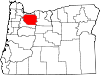
Clackamas County, Oregon
Clackamas County is a county located in the U.S. state of Oregon. The county was named after the Native Americans living in the area, the Clackamas Indians, who were part of the Chinookan people. As of 2010, the population was 375,992...
.
Current listings
| Site name | Image | Date listed | Location | City or Town | Summary | |
|---|---|---|---|---|---|---|
| 1 | Capt. John C. Ainsworth House Capt. John C. Ainsworth House The John C. Ainsworth House is a historic building in Oregon City, Oregon, United States. It was built in 1851 for John C. Ainsworth, the main founder of the Oregon Steam Navigation Company. It is one of the oldest structures in the Portland Area and remains in good condition. It is also the only... |
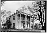 |
19131 S. Leland Road 45.32944°N 122.603°W |
Oregon City Oregon City, Oregon Oregon City was the first city in the United States west of the Rocky Mountains to be incorporated. It is the county seat of Clackamas County, Oregon... |
||
| 2 | Daniel Albright Farm | image pending | 9912 S Wildcat Road 45.06966°N 122.6596°W |
Marquam Marquam, Oregon Marquam is an unincorporated community in Clackamas County, Oregon, United States. It is located on Oregon Route 213, between the cities of Molalla and Silverton. Marquam was named for pioneer settler Alfred Marquam, who came to Oregon in 1845 from the east . He secured a donation land claim of ,... vicinity |
||
| 3 | Herman Anthony Farm | image pending | 10205 S New Era Road 45.29568°N 122.6554°W |
Canby Canby, Oregon Canby is a city in Clackamas County, Oregon, United States. The population was 15,829 at the 2010 census. It is located on Oregon Route 99E, two miles northeast of Barlow.-History:... |
||
| 4 | Charles C. Babcock House | image pending | 1214 Washington Street 45.36008°N 122.6012°W |
Oregon City Oregon City, Oregon Oregon City was the first city in the United States west of the Rocky Mountains to be incorporated. It is the county seat of Clackamas County, Oregon... |
||
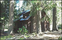
| 5 | Bagby Guard Station Bagby Guard Station Bagby Guard Station is a rustic cabin located in the Mount Hood National Forest in western Oregon, United States. It is adjacent to Bagby Hot Springs. The guard station was originally built to house fire crews assigned to patrol the surrounding National Forest... |
Forest Service United States Forest Service The United States Forest Service is an agency of the United States Department of Agriculture that administers the nation's 155 national forests and 20 national grasslands, which encompass... Road 70 44.93476°N 122.1735°W |
Estacada Estacada, Oregon Estacada is a city in Clackamas County, Oregon, United States, about 30 miles southeast of Portland. The population was 2,695 at the 2010 census. -History:The Estacada post office opened in February 1904 and the city was incorporated in May 1905... vicinity |
|||
| 6 | Lawrence D. Bailey House | image pending | 13908 SE Fair Oaks Avenue 45.42302°N 122.651°W |
Milwaukie Milwaukie, Oregon Milwaukie is a city in Clackamas County, Oregon, United States. A very small portion of the city extends into Multnomah County. The population was 20,291 at the 2010 census. Founded in 1848 on the banks of the Willamette River, the city, known as the Dogwood City of the West, was incorporated in... |
||
| 7 | Horace Baker Log Cabin Horace Baker Log Cabin The Horace Baker Log Cabin is a Log Cabin built in 1856 by pioneer Horace Baker. It is located near Carver, Oregon.-External links:***... |
S. Hattan Road near S. Gronlund Road 45.39024°N 122.4965°W |
Carver Carver, Oregon Carver is an unincorporated community in Clackamas County, Oregon, United States, which as of 2004, is part of the city of Damascus, Oregon. Before 2004, when the city of Damascus incorporated, Carver was an independent, unincorporated community... vicinity |
|||
| 8 | Dr. Forbes Barclay House | 719 Center Street 45.35699°N 122.6058°W |
Oregon City Oregon City, Oregon Oregon City was the first city in the United States west of the Rocky Mountains to be incorporated. It is the county seat of Clackamas County, Oregon... |
Dr. Barclay built this house in 1849, after retiring Retirement Retirement is the point where a person stops employment completely. A person may also semi-retire by reducing work hours.Many people choose to retire when they are eligible for private or public pension benefits, although some are forced to retire when physical conditions don't allow the person to... from 10 years as a physician Physician A physician is a health care provider who practices the profession of medicine, which is concerned with promoting, maintaining or restoring human health through the study, diagnosis, and treatment of disease, injury and other physical and mental impairments... with the Hudson's Bay Company Hudson's Bay Company The Hudson's Bay Company , abbreviated HBC, or "The Bay" is the oldest commercial corporation in North America and one of the oldest in the world. A fur trading business for much of its existence, today Hudson's Bay Company owns and operates retail stores throughout Canada... at Fort Vancouver Fort Vancouver Fort Vancouver was a 19th century fur trading outpost along the Columbia River that served as the headquarters of the Hudson's Bay Company in the company's Columbia District... . In Oregon City, he continued medical practice as well as holding a variety of public offices. The house was moved from its original location to its present address in the 1930s. |
||
| 9 | Barlow Road Barlow Road The Barlow Road is a historic road in what is now the U.S. state of Oregon. It was built in 1846 by Sam Barlow and Philip Foster, with authorization of the Provisional Legislature of Oregon, and served as the last overland segment of the Oregon Trail... |
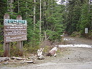 |
Mount Hood National Forest Mount Hood National Forest The Mount Hood National Forest is located east of the city of Portland, Oregon, and the northern Willamette River valley. The Forest extends south from the Columbia River Gorge across more than of forested mountains, lakes and streams to the Olallie Scenic Area, a high lake basin under the slopes... , north of the line of the Salmon Salmon River (Clackamas County, Oregon) The Salmon River is a 33.9 mile river in Oregon's Cascade Range and drains a portion of southwestern Mount Hood.The entire length of the river is protected National Wild and Scenic River, the only such river in the contiguous 48 states.... and White White River (Oregon) The White River is a tributary of the Deschutes River, approximately 50 mi long, in north central Oregon in the United States. It drains a scenic mountainous area of the Columbia Plateau on the east side of the Cascade Range southeast of Mount Hood. In the 1840s, a section of the Oregon... rivers from southwest of Wamic to Rhododendron (See also Wasco National Register of Historic Places listings in Wasco County, Oregon The following list includes all of the National Register of Historic Places listings in Wasco County, Oregon, and offers brief descriptive information about each of them. The National Register of Historic Places recognizes buildings, structures, objects, sites, and districts of national, state, or... and Hood River National Register of Historic Places listings in Hood River County, Oregon The following list presents the full set of National Register of Historic Places listings in Hood River County, Oregon, and offers brief descriptive information about each of them. The National Register of Historic Places recognizes buildings, structures, objects, sites, and districts of national,... counties.) 45°13′51"N 121°34′43"W (approx.) |
Rhododendron Rhododendron, Oregon Rhododendron is an unincorporated community in Clackamas County, Oregon, United States. It is located within the Mount Hood Corridor, between Government Camp and Zigzag on U.S. Route 26... to Wamic Wamic, Oregon Wamic is a census-designated place and unincorporated community in Wasco County, Oregon, United States. The population was 36 at the 2000 census.-Geography:Wamic is located at .... |
Beginning with its construction by Sam Barlow Sam Barlow Samuel Kimbrough Barlow was a pioneer in the area that became the U.S. state of Oregon, and was key in establishing the Barlow Road, the most widely chosen final segment to the Oregon Trail.-Biography:... in 1846, this toll road Toll road A toll road is a privately or publicly built road for which a driver pays a toll for use. Structures for which tolls are charged include toll bridges and toll tunnels. Non-toll roads are financed using other sources of revenue, most typically fuel tax or general tax funds... provided the first overland connection for wagons between The Dalles The Dalles, Oregon The Dalles is the largest city and county seat of Wasco County, Oregon, United States. The name of the city comes from the French word dalle The Dalles is the largest city and county seat of Wasco County, Oregon, United States. The name of the city comes from the French word dalle The Dalles is... and Oregon City Oregon City, Oregon Oregon City was the first city in the United States west of the Rocky Mountains to be incorporated. It is the county seat of Clackamas County, Oregon... over the south flanks of Mount Hood Mount Hood Mount Hood, called Wy'east by the Multnomah tribe, is a stratovolcano in the Cascade Volcanic Arc of northern Oregon. It was formed by a subduction zone and rests in the Pacific Northwest region of the United States... , and offered a majority of Oregon Trail Oregon Trail The Oregon Trail is a historic east-west wagon route that connected the Missouri River to valleys in Oregon and locations in between.After 1840 steam-powered riverboats and steamboats traversing up and down the Ohio, Mississippi and Missouri rivers sped settlement and development in the flat... emigrants an alternative to the hazardous raft passage down the Columbia River Columbia River The Columbia River is the largest river in the Pacific Northwest region of North America. The river rises in the Rocky Mountains of British Columbia, Canada, flows northwest and then south into the U.S. state of Washington, then turns west to form most of the border between Washington and the state... from The Dalles to Fort Vancouver Fort Vancouver Fort Vancouver was a 19th century fur trading outpost along the Columbia River that served as the headquarters of the Hudson's Bay Company in the company's Columbia District... . |
|
| 10 | William Barlow House William Barlow House William Barlow House is a historic building in Clackamas County, Oregon, United States.Barlow House was home to William Barlow, namesake of the city of Barlow and son of Samuel K. Barlow, who built the Barlow Road. The house is located south of Barlow, between Canby and Aurora on 99E... |
24670 S Oregon Route 99E 45.25238°N 122.7176°W |
Barlow Barlow, Oregon Barlow is a city in Clackamas County, Oregon, United States. The population was 135 at the 2010 census.-History:Barlow is named for William Barlow, the son of Samuel K. Barlow . Samuel bought the donation land claim in which Barlow is located from Thomas McKay on September 17, 1850... |
|||
| 11 | John M. and Elizabeth Bates House No. 2 | image pending | 16948 SW Bryant Road 45.40314°N 122.7231°W |
Lake Oswego Lake Oswego, Oregon Lake Oswego is a city located primarily in Clackamas County in the U.S. state of Oregon. Small portions of the city are also located in neighboring Multnomah and Washington counties. Located south of Portland surrounding the Oswego Lake, the town was founded in 1847 and incorporated as Oswego in... |
||
| 12 | John M. and Elizabeth Bates House No. 3 | image pending | 16884 SW Bryant Road 45.40346°N 122.7231°W |
Lake Oswego Lake Oswego, Oregon Lake Oswego is a city located primarily in Clackamas County in the U.S. state of Oregon. Small portions of the city are also located in neighboring Multnomah and Washington counties. Located south of Portland surrounding the Oswego Lake, the town was founded in 1847 and incorporated as Oswego in... |
||
| 13 | John M. and Elizabeth Bates House No. 4 | image pending | 4101 South Shore Boulevard 45.40441°N 122.718°W |
Lake Oswego Lake Oswego, Oregon Lake Oswego is a city located primarily in Clackamas County in the U.S. state of Oregon. Small portions of the city are also located in neighboring Multnomah and Washington counties. Located south of Portland surrounding the Oswego Lake, the town was founded in 1847 and incorporated as Oswego in... |
||
| 14 | Bell Station Store | 9300 SE Bell Avenue 45.45592°N 122.5928°W |
Milwaukie Milwaukie, Oregon Milwaukie is a city in Clackamas County, Oregon, United States. A very small portion of the city extends into Multnomah County. The population was 20,291 at the 2010 census. Founded in 1848 on the banks of the Willamette River, the city, known as the Dogwood City of the West, was incorporated in... vicinity |
|||
| 15 | Dr. Walter Black House | image pending | 1125 Maple Street 45.40962°N 122.6716°W |
Lake Oswego Lake Oswego, Oregon Lake Oswego is a city located primarily in Clackamas County in the U.S. state of Oregon. Small portions of the city are also located in neighboring Multnomah and Washington counties. Located south of Portland surrounding the Oswego Lake, the town was founded in 1847 and incorporated as Oswego in... |
||
| 16 | W.S. and Gladys Boutwell House | image pending | 920 SW Fairway Road 45.417°N 122.6858°W |
Lake Oswego Lake Oswego, Oregon Lake Oswego is a city located primarily in Clackamas County in the U.S. state of Oregon. Small portions of the city are also located in neighboring Multnomah and Washington counties. Located south of Portland surrounding the Oswego Lake, the town was founded in 1847 and incorporated as Oswego in... |
||
| 17 | John F. and John H. Broetje House | image pending | 3101 SE Courtney Avenue 45.42255°N 122.6307°W |
Milwaukie Milwaukie, Oregon Milwaukie is a city in Clackamas County, Oregon, United States. A very small portion of the city extends into Multnomah County. The population was 20,291 at the 2010 census. Founded in 1848 on the banks of the Willamette River, the city, known as the Dogwood City of the West, was incorporated in... |
||
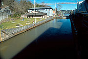
| 18 | Canemah Historic District Canemah, Oregon Canemah was an early settlement in the U.S. state of Oregon located near Willamette Falls on the Willamette River. It is now a district within Oregon City.-Location:... |
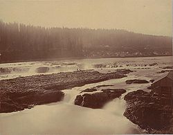 |
Roughly bounded by the Willamette River Willamette River The Willamette River is a major tributary of the Columbia River, accounting for 12 to 15 percent of the Columbia's flow. The Willamette's main stem is long, lying entirely in northwestern Oregon in the United States... , 5th Avenue, Marshall Street, and Paquet Street 45.34616°N 122.6222°W |
Oregon City Oregon City, Oregon Oregon City was the first city in the United States west of the Rocky Mountains to be incorporated. It is the county seat of Clackamas County, Oregon... |
Established as the port Port A port is a location on a coast or shore containing one or more harbors where ships can dock and transfer people or cargo to or from land.... at the upstream end of the portage Portage Portage or portaging refers to the practice of carrying watercraft or cargo over land to avoid river obstacles, or between two bodies of water. A place where this carrying occurs is also called a portage; a person doing the carrying is called a porter.The English word portage is derived from the... around the Willamette Falls Willamette Falls The Willamette Falls is a natural waterfall on the Willamette River between Oregon City and West Linn, Oregon, in the United States. It is the largest waterfall in the Pacific Northwest and the eighteenth largest in the world by water volume. Horseshoe in shape, it is wide and high with a flow... , Canemah became a thriving transportation hub and center of steamboat Steamboat A steamboat or steamship, sometimes called a steamer, is a ship in which the primary method of propulsion is steam power, typically driving propellers or paddlewheels... construction Boat building Boat building, one of the oldest branches of engineering, is concerned with constructing the hulls of boats and, for sailboats, the masts, spars and rigging.-Parts:* Bow - the front and generally sharp end of the hull... and river shipping Riverboat A riverboat is a ship built boat designed for inland navigation on lakes, rivers, and artificial waterways. They are generally equipped and outfitted as work boats in one of the carrying trades, for freight or people transport, including luxury units constructed for entertainment enterprises, such... in a period (about 1850 - 1878) when these industries were critical to the Oregon economy. As a residential neighborhood of Oregon City today, Canemah retains much of its 19th-century character. |
|
| 19 | Clackamas Lake Ranger Station Historic District Clackamas Lake Ranger Station Historic District The Clackamas Lake Ranger Station Historic District is a Forest Service compound consisting of eleven historic buildings located in the Mount Hood National Forest in the Cascade Mountains of northern Oregon. It was originally built as a district ranger station for the Clackamas Lake Ranger... |
 |
Forest Service United States Forest Service The United States Forest Service is an agency of the United States Department of Agriculture that administers the nation's 155 national forests and 20 national grasslands, which encompass... Road 42 45.10296°N 121.7471°W |
Government Camp Government Camp, Oregon Government Camp is an unincorporated community located in Clackamas County, Oregon, United States, south of Mount Hood and north of Tom, Dick and Harry Mountain. It is a gateway to several ski resorts, the most popular being Timberline Lodge and Mount Hood Skibowl. Also, Government Camp has its... vicinity |
||
| 20 | Elizabeth Clark House | 812 John Adams Street 45.35682°N 122.6033°W |
Oregon City Oregon City, Oregon Oregon City was the first city in the United States west of the Rocky Mountains to be incorporated. It is the county seat of Clackamas County, Oregon... |
|||
| 21 | Harvey Cross House Harvey Cross House The Harvey Cross House was a building constructed in 1888 and then moved to Oregon City, Oregon between 1911 and 1925. The house was built by Harvey Cross, one of the founders of the Mount Hood and Barlow Road and with partners founded the Gladstone Real Estate Association, which eventually led up... |
809 Washington Street 45.35723°N 122.6042°W |
Oregon City Oregon City, Oregon Oregon City was the first city in the United States west of the Rocky Mountains to be incorporated. It is the county seat of Clackamas County, Oregon... |
|||
| 22 | Damascus School | 14711 SE Anderson Road 45.41633°N 122.4586°W |
Damascus Damascus, Oregon Damascus is a city in Clackamas County, Oregon, United States. Incorporated in 2004, the city is located east of Happy Valley and Interstate 205 and west of Boring. The area that later became the city had a population of 9,022 in 2000... |
|||
| 23 | Marshall Dana House | image pending | 15725 SE Dana Avenue 45.40927°N 122.6488°W |
Milwaukie Milwaukie, Oregon Milwaukie is a city in Clackamas County, Oregon, United States. A very small portion of the city extends into Multnomah County. The population was 20,291 at the 2010 census. Founded in 1848 on the banks of the Willamette River, the city, known as the Dogwood City of the West, was incorporated in... |
||
| 24 | John and Magdalena Davis Farm | image pending | 13678 S Spangler Road 45.25551°N 122.5903°W |
Oregon City Oregon City, Oregon Oregon City was the first city in the United States west of the Rocky Mountains to be incorporated. It is the county seat of Clackamas County, Oregon... vicinity |
||
| 25 | Horace L. Dibble House | 616 S Molalla Avenue 45.1427°N 122.5795°W |
Molalla Molalla, Oregon Molalla is a city in Clackamas County, Oregon, United States. The population was 5,647 at the 2000 census.-History:Molalla was named after the Molalla River, which in turn was named for the Molala, a Native American tribe that inhabited the area. William H. Vaughan took up a donation land claim in... |
|||
| 26 | Francis Ermatinger House Francis Ermatinger House The Francis Ermatinger House is located in Oregon City, Oregon, United States. Built by Francis Ermatinger in 1845, it is the oldest house in Clackamas County... |
619 6th Street 45.35554°N 122.6056°W |
Oregon City Oregon City, Oregon Oregon City was the first city in the United States west of the Rocky Mountains to be incorporated. It is the county seat of Clackamas County, Oregon... |
|||
| 27 | Charles W. Ertz House | 1650 North Shore Road 45.41539°N 122.684°W |
Lake Oswego Lake Oswego, Oregon Lake Oswego is a city located primarily in Clackamas County in the U.S. state of Oregon. Small portions of the city are also located in neighboring Multnomah and Washington counties. Located south of Portland surrounding the Oswego Lake, the town was founded in 1847 and incorporated as Oswego in... |
|||
| 28 | First Congregational Church of Oregon City | 710 6th Street 45.35518°N 122.605°W |
Oregon City Oregon City, Oregon Oregon City was the first city in the United States west of the Rocky Mountains to be incorporated. It is the county seat of Clackamas County, Oregon... |
|||
| 29 | Philip Foster Farm Philip Foster Farm Philip Foster Farm is a historic site in Eagle Creek, Oregon, United States, near the city of Estacada. The farm is on a land claim purchased in 1847 by American pioneer Philip Foster. Foster built a store, house, and barn at the farm... |
29912 SE. Oregon Route 211 45.35856°N 122.3553°W |
Eagle Creek Eagle Creek, Oregon Eagle Creek is an unincorporated community in Clackamas County, Oregon, United States. It is located seven miles southwest of Sandy, seven miles north of Estacada, and five miles southeast of Carver, at the junction of Oregon Routes 224 and 211, on the Clackamas River.-Background and history:The... |
|||
| 30 | Clarence E. Francis House | image pending | 9717 SE Cambridge Lane 45.45253°N 122.6496°W |
Milwaukie Milwaukie, Oregon Milwaukie is a city in Clackamas County, Oregon, United States. A very small portion of the city extends into Multnomah County. The population was 20,291 at the 2010 census. Founded in 1848 on the banks of the Willamette River, the city, known as the Dogwood City of the West, was incorporated in... |
||
| 31 | Erwin Charles Hackett House | image pending | 415 17th Street 45.36441°N 122.598°W |
Oregon City Oregon City, Oregon Oregon City was the first city in the United States west of the Rocky Mountains to be incorporated. It is the county seat of Clackamas County, Oregon... |
||
| 32 | Hall–Chaney House | image pending | 10200 SE Cambridge Lane 45.44915°N 122.6486°W |
Milwaukie Milwaukie, Oregon Milwaukie is a city in Clackamas County, Oregon, United States. A very small portion of the city extends into Multnomah County. The population was 20,291 at the 2010 census. Founded in 1848 on the banks of the Willamette River, the city, known as the Dogwood City of the West, was incorporated in... vicinity |
||
| 33 | William L. Holmes House | image pending | 536 Holmes Lane 45.34212°N 122.601°W |
Oregon City Oregon City, Oregon Oregon City was the first city in the United States west of the Rocky Mountains to be incorporated. It is the county seat of Clackamas County, Oregon... |
||
| 34 | Howard's Gristmill | 26401 S Oregon Route 213 45.22377°N 122.5819°W |
Mulino Mulino, Oregon Mulino, Oregon is a hamlet located in Clackamas County, Oregon, United States, on Oregon Route 213 between the cities of Oregon City and Molalla.-History:... |
|||
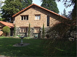
| 35 | Iron Workers' Cottage |  |
40 Wilbur Street 45°24′45.85"N 122°39′47.94"W |
Lake Oswego Lake Oswego, Oregon Lake Oswego is a city located primarily in Clackamas County in the U.S. state of Oregon. Small portions of the city are also located in neighboring Multnomah and Washington counties. Located south of Portland surrounding the Oswego Lake, the town was founded in 1847 and incorporated as Oswego in... |
||
| 36 | C.S. "Sam" Jackson Log House | image pending | 14999 S Springwater Road 45.38905°N 122.4933°W |
Oregon City Oregon City, Oregon Oregon City was the first city in the United States west of the Rocky Mountains to be incorporated. It is the county seat of Clackamas County, Oregon... vicinity |
||
| 37 | Carl C. Jantzen Estate | image pending | 1850 North Shore Road 45°24′51.83"N 122°41′14.32"W |
Lake Oswego Lake Oswego, Oregon Lake Oswego is a city located primarily in Clackamas County in the U.S. state of Oregon. Small portions of the city are also located in neighboring Multnomah and Washington counties. Located south of Portland surrounding the Oswego Lake, the town was founded in 1847 and incorporated as Oswego in... |
||
| 38 | Andrew J. and Anna B. Johnston Farmstead | image pending | 18025 S Harding Road 45.34538°N 122.4228°W |
Oregon City Oregon City, Oregon Oregon City was the first city in the United States west of the Rocky Mountains to be incorporated. It is the county seat of Clackamas County, Oregon... |
||
| 39 | William Knight House | 525 SW 4th Avenue 45.25818°N 122.696°W |
Canby Canby, Oregon Canby is a city in Clackamas County, Oregon, United States. The population was 15,829 at the 2010 census. It is located on Oregon Route 99E, two miles northeast of Barlow.-History:... |
|||
| 40 | Kraft–Brandes–Culberston Farmstead | 2525 N Baker Drive 45.28678°N 122.7071°W |
Canby Canby, Oregon Canby is a city in Clackamas County, Oregon, United States. The population was 15,829 at the 2010 census. It is located on Oregon Route 99E, two miles northeast of Barlow.-History:... vicinity |
|||
| 41 | Ladd Estate Company Model House | 432 Country Club Road 45.42109°N 122.6761°W |
Lake Oswego Lake Oswego, Oregon Lake Oswego is a city located primarily in Clackamas County in the U.S. state of Oregon. Small portions of the city are also located in neighboring Multnomah and Washington counties. Located south of Portland surrounding the Oswego Lake, the town was founded in 1847 and incorporated as Oswego in... |
|||
| 42 | Lake Oswego Hunt Club Ensemble | 2725 SW Iron Mountain Boulevard 45.4125°N 122.7053°W |
Lake Oswego Lake Oswego, Oregon Lake Oswego is a city located primarily in Clackamas County in the U.S. state of Oregon. Small portions of the city are also located in neighboring Multnomah and Washington counties. Located south of Portland surrounding the Oswego Lake, the town was founded in 1847 and incorporated as Oswego in... |
|||
| 43 | Lake Oswego Odd Fellows Hall Lake Oswego Odd Fellows Hall The Lake Oswego Odd Fellows Hall, in Lake Oswego, Oregon, was built in 1890. It was listed on the National Register of Historic Places in 1979. It served historically as a professional building, as a clubhouse, as a meeting hall, and as a specialty store.... |
295 Durham Street 45.41362°N 122.6624°W |
Lake Oswego Lake Oswego, Oregon Lake Oswego is a city located primarily in Clackamas County in the U.S. state of Oregon. Small portions of the city are also located in neighboring Multnomah and Washington counties. Located south of Portland surrounding the Oswego Lake, the town was founded in 1847 and incorporated as Oswego in... |
|||
| 44 | Charles David Latourette House | image pending | 503 High Street 45.35582°N 122.6082°W |
Oregon City Oregon City, Oregon Oregon City was the first city in the United States west of the Rocky Mountains to be incorporated. It is the county seat of Clackamas County, Oregon... |
||
| 45 | DeWitt Clinton Latourette House | image pending | 914 Madison Street 45.35671°N 122.6008°W |
Oregon City Oregon City, Oregon Oregon City was the first city in the United States west of the Rocky Mountains to be incorporated. It is the county seat of Clackamas County, Oregon... |
||
| 46 | Lewthwaite–Moffatt House | image pending | 4891 Willamette Falls Drive 45.35976°N 122.613°W |
West Linn West Linn, Oregon West Linn is a city in Clackamas County, Oregon, United States. Now a prosperous southern suburb of Portland, West Linn has a history of early development, prompted by the opportunity to harvest energy from nearby Willamette Falls. It was named after Senator Dr. Lewis Fields Linn of Ste... |
||
| 47 | Macksburg Lutheran Church | 10190 S Macksburg Road 45.21368°N 122.657°W |
Canby Canby, Oregon Canby is a city in Clackamas County, Oregon, United States. The population was 15,829 at the 2010 census. It is located on Oregon Route 99E, two miles northeast of Barlow.-History:... |
|||
| 48 | Mathieson–Worthington House | image pending | 885 McVey Avenue 45.4091°N 122.6708°W |
Lake Oswego Lake Oswego, Oregon Lake Oswego is a city located primarily in Clackamas County in the U.S. state of Oregon. Small portions of the city are also located in neighboring Multnomah and Washington counties. Located south of Portland surrounding the Oswego Lake, the town was founded in 1847 and incorporated as Oswego in... |
||
| 49 | Morton Matthew McCarver House | image pending | 554 Warner–Parrott Road 45.33738°N 122.6114°W |
Oregon City Oregon City, Oregon Oregon City was the first city in the United States west of the Rocky Mountains to be incorporated. It is the county seat of Clackamas County, Oregon... |
Named for pioneer and city founder Morton M. McCarver. | |
| 50 | McLoughlin House National Historic Site | 713 Center Street 45°21′26.38"N 122°36′20.96"W |
Oregon City Oregon City, Oregon Oregon City was the first city in the United States west of the Rocky Mountains to be incorporated. It is the county seat of Clackamas County, Oregon... |
Dr. John McLoughlin John McLoughlin Dr. John McLoughlin, baptized Jean-Baptiste McLoughlin, was the Chief Factor of the Columbia Fur District of the Hudson's Bay Company at Fort Vancouver. He was later known as the "Father of Oregon" for his role in assisting the American cause in the Oregon Country in the Pacific Northwest... , known as the "Father of Oregon" for the support he provided to emigrants on the Oregon Trail Oregon Trail The Oregon Trail is a historic east-west wagon route that connected the Missouri River to valleys in Oregon and locations in between.After 1840 steam-powered riverboats and steamboats traversing up and down the Ohio, Mississippi and Missouri rivers sped settlement and development in the flat... , built this house in 1846 upon his retirement Retirement Retirement is the point where a person stops employment completely. A person may also semi-retire by reducing work hours.Many people choose to retire when they are eligible for private or public pension benefits, although some are forced to retire when physical conditions don't allow the person to... from 20 years as Chief Factor of the Hudson's Bay Company Hudson's Bay Company The Hudson's Bay Company , abbreviated HBC, or "The Bay" is the oldest commercial corporation in North America and one of the oldest in the world. A fur trading business for much of its existence, today Hudson's Bay Company owns and operates retail stores throughout Canada... 's Fort Vancouver Fort Vancouver Fort Vancouver was a 19th century fur trading outpost along the Columbia River that served as the headquarters of the Hudson's Bay Company in the company's Columbia District... . In retirement, he continued his activities as mayor Mayor In many countries, a Mayor is the highest ranking officer in the municipal government of a town or a large urban city.... of Oregon City, a private businessman, and philanthropist Philanthropy Philanthropy etymologically means "the love of humanity"—love in the sense of caring for, nourishing, developing, or enhancing; humanity in the sense of "what it is to be human," or "human potential." In modern practical terms, it is "private initiatives for public good, focusing on quality of... . The house was moved from its original location beside the Willamette River Willamette River The Willamette River is a major tributary of the Columbia River, accounting for 12 to 15 percent of the Columbia's flow. The Willamette's main stem is long, lying entirely in northwestern Oregon in the United States... to its current blufftop site in 1909. |
||
| 51 | James Milne House | image pending | 224 Center Street 45.35327°N 122.6094°W |
Oregon City Oregon City, Oregon Oregon City was the first city in the United States west of the Rocky Mountains to be incorporated. It is the county seat of Clackamas County, Oregon... |
||
| 52 | Oregon Iron Company Furnace | George Rogers Park 45.41092°N 122.6605°W |
Lake Oswego Lake Oswego, Oregon Lake Oswego is a city located primarily in Clackamas County in the U.S. state of Oregon. Small portions of the city are also located in neighboring Multnomah and Washington counties. Located south of Portland surrounding the Oswego Lake, the town was founded in 1847 and incorporated as Oswego in... |
|||
| 53 | Oregon Trail, Barlow Road Segment | image pending | Wildwood Recreation Site Wildwood Recreation Site The Wildwood Recreation Site is a natural recreation area surrounded by the Mount Hood National Forest in northern Oregon, USA. It contains of natural rainforest and five miles of interpretive trail along the Salmon River. It features Cascade Streamwatch, an underwater viewport into a mountain... 45.3637°N 121.9852°W |
Wemme Wemme, Oregon Wemme is an unincorporated community in Clackamas County, Oregon, United States. It is located within the Mount Hood Corridor, between Welches and Brightwood along U.S. Route 26. It is one of the communities that make up the Villages at Mount Hood.... vicinity |
A 5 acres (20,234.3 m²) property including a segment of an alternate route of the Oregon Trail Oregon Trail The Oregon Trail is a historic east-west wagon route that connected the Missouri River to valleys in Oregon and locations in between.After 1840 steam-powered riverboats and steamboats traversing up and down the Ohio, Mississippi and Missouri rivers sped settlement and development in the flat... /Barlow Road Barlow Road The Barlow Road is a historic road in what is now the U.S. state of Oregon. It was built in 1846 by Sam Barlow and Philip Foster, with authorization of the Provisional Legislature of Oregon, and served as the last overland segment of the Oregon Trail... |
|
| 54 | Richard B. Petzold Building | 714 Main Street 45.35791°N 122.6082°W |
Oregon City Oregon City, Oregon Oregon City was the first city in the United States west of the Rocky Mountains to be incorporated. It is the county seat of Clackamas County, Oregon... |
|||
| 55 | Richard Petzold House | 504 6th Street 45.35599°N 122.6066°W |
Oregon City Oregon City, Oregon Oregon City was the first city in the United States west of the Rocky Mountains to be incorporated. It is the county seat of Clackamas County, Oregon... |
|||
| 56 | Wilbur and Evelyn Reid's Alderbrook Lodge | image pending | 26863 E. Rolling Riffle Lane 45°19′49.33"N 121°54′45.34"W |
Rhododendron Rhododendron, Oregon Rhododendron is an unincorporated community in Clackamas County, Oregon, United States. It is located within the Mount Hood Corridor, between Government Camp and Zigzag on U.S. Route 26... |
||
| 57 | River Mill Hydroelectric Project River Mill Hydroelectric Project River Mill Hydroelectric Project, also known as River Mill Dam and Station M, is a hydroelectric dam and powerhouse in Clackamas County, Oregon, United States. It is just north of Estacada, Oregon on the Clackamas River at river mile 23.5.... |
image pending | 30878 NW Evergreen Way 45°17′56.09"N 122°20′48.01"W |
Estacada Estacada, Oregon Estacada is a city in Clackamas County, Oregon, United States, about 30 miles southeast of Portland. The population was 2,695 at the 2010 census. -History:The Estacada post office opened in February 1904 and the city was incorporated in May 1905... vicinity |
||
| 58 | Robbins–Melcher–Schatz Farmstead | 4875 SW Schatz Road 45.35731°N 122.7277°W |
Tualatin Tualatin, Oregon Tualatin is a city located primarily in Washington County in the U.S. state of Oregon. A small portion of the city is also located in neighboring Clackamas County. It is a southwestern suburb in the Portland Metropolitan Area that is located south of Tigard... vicinity |
|||
| 59 | Rock Corral on the Barlow Road | image pending | Off U.S. Route 26 U.S. Route 26 in Oregon In the U.S. state of Oregon, U.S. Route 26 is a major cross-state state highway, connecting U.S. Route 101 on the Oregon Coast near Seaside with the Idaho state line east of Nyssa. Local highway names include the Sunset Highway No. 47, Mount Hood Highway No. 26, and John Day Highway No... near the Sandy River Sandy River (Oregon) The Sandy River is a tributary of the Columbia River in northwestern Oregon in the United States. Measured by a United States Geological Survey gauge downstream of the Sandy's confluence with the Bull Run River, from the mouth, the river's average discharge is . The maximum daily recorded flow... 45.38329°N 122.0656°W |
Brightwood Brightwood, Oregon Brightwood is an unincorporated community within the Mount Hood Corridor in Clackamas County, Oregon, United States. It is located between Wemme and Sandy just off of U.S. Route 26 at an elevation of 355 meters. It is one of the communities that make up the Villages at Mount Hood.A post office... vicinity |
||
| 60 | Rock Creek Methodist Church | image pending | Intersection of S. Sconce Road and S. Stuwe Road 45.15878°N 122.7143°W |
Molalla Molalla, Oregon Molalla is a city in Clackamas County, Oregon, United States. The population was 5,647 at the 2000 census.-History:Molalla was named after the Molalla River, which in turn was named for the Molala, a Native American tribe that inhabited the area. William H. Vaughan took up a donation land claim in... vicinity |
||
| 61 | George Rogers House George Rogers House (Oregon) George Rogers House is a private home in Lake Oswego, Oregon, United States. Located at the corner of Durham Street and Wilbur Street, the house was the home of George Rogers, who donated the land to the City of Lake Oswego that became George Rogers Park. During the time that Lake Oswego was an... |
 |
59 SW Wilbur Street 45.41296°N 122.6633°W |
Lake Oswego Lake Oswego, Oregon Lake Oswego is a city located primarily in Clackamas County in the U.S. state of Oregon. Small portions of the city are also located in neighboring Multnomah and Washington counties. Located south of Portland surrounding the Oswego Lake, the town was founded in 1847 and incorporated as Oswego in... |
||
| 62 | Sherrard–Fenton House | image pending | 13100 SW Riverside Drive 45.43085°N 122.6559°W |
Lake Oswego Lake Oswego, Oregon Lake Oswego is a city located primarily in Clackamas County in the U.S. state of Oregon. Small portions of the city are also located in neighboring Multnomah and Washington counties. Located south of Portland surrounding the Oswego Lake, the town was founded in 1847 and incorporated as Oswego in... |
||
| 63 | William Shindler House | image pending | 3235 SE Harrison Street 45.44662°N 122.6292°W |
Milwaukie Milwaukie, Oregon Milwaukie is a city in Clackamas County, Oregon, United States. A very small portion of the city extends into Multnomah County. The population was 20,291 at the 2010 census. Founded in 1848 on the banks of the Willamette River, the city, known as the Dogwood City of the West, was incorporated in... |
||
| 64 | Shipley–Cook Farmstead | image pending | 18451 SW Stafford Road 45°23′31.51"N 122°41′25.92"W |
Lake Oswego Lake Oswego, Oregon Lake Oswego is a city located primarily in Clackamas County in the U.S. state of Oregon. Small portions of the city are also located in neighboring Multnomah and Washington counties. Located south of Portland surrounding the Oswego Lake, the town was founded in 1847 and incorporated as Oswego in... vicinity |
||
| 65 | Silcox Hut Silcox Hut The Silcox Hut is a small rustic mid-mountain lodge located at elevation on Mount Hood, Oregon, United States. It is approximately vertical above Timberline Lodge and roughly one mile distance directly up the mountain.... |
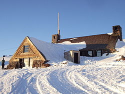 |
Timberline Road 45.34454°N 121.7095°W |
Government Camp Government Camp, Oregon Government Camp is an unincorporated community located in Clackamas County, Oregon, United States, south of Mount Hood and north of Tom, Dick and Harry Mountain. It is a gateway to several ski resorts, the most popular being Timberline Lodge and Mount Hood Skibowl. Also, Government Camp has its... |
||
| 66 | R.S. Smith Motor Company Building | 39150 Pioneer Boulevard 45.39624°N 122.2606°W |
Sandy Sandy, Oregon Sandy is a city located in Clackamas County, Oregon, United States, and named after the nearby Sandy River. As of the 2000 census, the city had a total population of 5,385, however the 2006 estimate shows 7,070 people.... |
|||
| 67 | St. John the Evangelist Roman Catholic Church | image pending | 68835 E Barlow Trail Road 45.3521°N 121.9564°W |
Welches Welches, Oregon Welches is an unincorporated community in Clackamas County, Oregon, United States. It is located within the Mount Hood Corridor between Zigzag and Wemme along U.S. Route 26. It is one of the communities that make up the Villages at Mount Hood.... vicinity |
||
| 68 | George Lincoln Storey House | image pending | 910 Pierce Street 45.3532°N 122.594°W |
Oregon City Oregon City, Oregon Oregon City was the first city in the United States west of the Rocky Mountains to be incorporated. It is the county seat of Clackamas County, Oregon... |
||
| 69 | Hiram A. Straight House | image pending | 16000 S Depot Lane 45.37466°N 122.5836°W |
Oregon City Oregon City, Oregon Oregon City was the first city in the United States west of the Rocky Mountains to be incorporated. It is the county seat of Clackamas County, Oregon... |
||
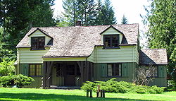
| 70 | Timberline Lodge | 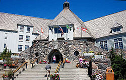 |
6 miles (9.6 km) north of Government Camp in Mount Hood National Forest 45°19′52"N 121°42′36"W |
Government Camp Government Camp, Oregon Government Camp is an unincorporated community located in Clackamas County, Oregon, United States, south of Mount Hood and north of Tom, Dick and Harry Mountain. It is a gateway to several ski resorts, the most popular being Timberline Lodge and Mount Hood Skibowl. Also, Government Camp has its... |
President President of the United States The President of the United States of America is the head of state and head of government of the United States. The president leads the executive branch of the federal government and is the commander-in-chief of the United States Armed Forces.... Franklin D. Roosevelt Franklin D. Roosevelt Franklin Delano Roosevelt , also known by his initials, FDR, was the 32nd President of the United States and a central figure in world events during the mid-20th century, leading the United States during a time of worldwide economic crisis and world war... dedicated Dedication Dedication is the act of consecrating an altar, temple, church or other sacred building. It also refers to the inscription of books or other artifacts when these are specifically addressed or presented to a particular person. This practice, which once was used to gain the patronage and support of... this lodge Hotel A hotel is an establishment that provides paid lodging on a short-term basis. The provision of basic accommodation, in times past, consisting only of a room with a bed, a cupboard, a small table and a washstand has largely been replaced by rooms with modern facilities, including en-suite bathrooms... at an elevation Elevation The elevation of a geographic location is its height above a fixed reference point, most commonly a reference geoid, a mathematical model of the Earth's sea level as an equipotential gravitational surface .... of 6,000 feet (1,830 m) on the south slope of Mount Hood Mount Hood Mount Hood, called Wy'east by the Multnomah tribe, is a stratovolcano in the Cascade Volcanic Arc of northern Oregon. It was formed by a subduction zone and rests in the Pacific Northwest region of the United States... in 1937. It is considered the finest example of 1930s-era Era An era is a commonly used word for long period of time. When used in science, for example geology, eras denote clearly defined periods of time of arbitrary but well defined length, such as for example the Mesozoic era from 252 Ma–66 Ma, delimited by a start event and an end event. When used in... "mountain Mountain Image:Himalaya_annotated.jpg|thumb|right|The Himalayan mountain range with Mount Everestrect 58 14 160 49 Chomo Lonzorect 200 28 335 52 Makalurect 378 24 566 45 Mount Everestrect 188 581 920 656 Tibetan Plateaurect 250 406 340 427 Rong River... architecture Architecture Architecture is both the process and product of planning, designing and construction. Architectural works, in the material form of buildings, are often perceived as cultural and political symbols and as works of art... " by the Works Progress Administration Works Progress Administration The Works Progress Administration was the largest and most ambitious New Deal agency, employing millions of unskilled workers to carry out public works projects, including the construction of public buildings and roads, and operated large arts, drama, media, and literacy projects... . |
|
| 71 | Upper Sandy Guard Station Cabin Upper Sandy Guard Station Cabin The Upper Sandy Guard Station Cabin is a log and stone building built in 1935. It was funded as part of the Federal work relief Emergency Relief Appropriations Act of that year, and also by funds from the City of Portland, Oregon.... |
4.5 mi (7.2 km). E. of jct. FS Rds. 18 and 1825, Mt. Hood National Forest 45°22′38.451"N 121°46′58.452"W |
Government Camp Government Camp, Oregon Government Camp is an unincorporated community located in Clackamas County, Oregon, United States, south of Mount Hood and north of Tom, Dick and Harry Mountain. It is a gateway to several ski resorts, the most popular being Timberline Lodge and Mount Hood Skibowl. Also, Government Camp has its... vicinity |
|||
| 72 | William Hatchette Vaughan House | 14900 S Macksburg Road 45.17085°N 122.5521°W |
Molalla Molalla, Oregon Molalla is a city in Clackamas County, Oregon, United States. The population was 5,647 at the 2000 census.-History:Molalla was named after the Molalla River, which in turn was named for the Molala, a Native American tribe that inhabited the area. William H. Vaughan took up a donation land claim in... vicinity |
|||
| 73 | Fred Vonder Ahe House and Summer Kitchen | 625 Metzler Avenue 45.14222°N 122.5808°W |
Molalla Molalla, Oregon Molalla is a city in Clackamas County, Oregon, United States. The population was 5,647 at the 2000 census.-History:Molalla was named after the Molalla River, which in turn was named for the Molala, a Native American tribe that inhabited the area. William H. Vaughan took up a donation land claim in... |
|||
| 74 | Nicholas O. Walden House | 1847 SE 5th Avenue 45.34276°N 122.654°W |
West Linn West Linn, Oregon West Linn is a city in Clackamas County, Oregon, United States. Now a prosperous southern suburb of Portland, West Linn has a history of early development, prompted by the opportunity to harvest energy from nearby Willamette Falls. It was named after Senator Dr. Lewis Fields Linn of Ste... |
|||
| 75 | Clara and Samuel B. Weinstein House | image pending | 16847 SW Greenbriar Road 45.40371°N 122.7081°W |
Lake Oswego Lake Oswego, Oregon Lake Oswego is a city located primarily in Clackamas County in the U.S. state of Oregon. Small portions of the city are also located in neighboring Multnomah and Washington counties. Located south of Portland surrounding the Oswego Lake, the town was founded in 1847 and incorporated as Oswego in... |
||
| 76 | White–Kellogg House | image pending | 19000 S Central Point Road 45.33148°N 122.6121°W |
Oregon City Oregon City, Oregon Oregon City was the first city in the United States west of the Rocky Mountains to be incorporated. It is the county seat of Clackamas County, Oregon... vicinity |
||
| 77 | Willamette Falls Locks Willamette Falls Locks The Willamette Falls Locks are a lock system on the Willamette River in the U.S. state of Oregon. Opened in 1873 and currently closed, they allow boat traffic on the Willamette to navigate beyond Willamette Falls... |
 |
West bank of the Willamette River Willamette River The Willamette River is a major tributary of the Columbia River, accounting for 12 to 15 percent of the Columbia's flow. The Willamette's main stem is long, lying entirely in northwestern Oregon in the United States... 45.35721°N 122.6145°W |
West Linn West Linn, Oregon West Linn is a city in Clackamas County, Oregon, United States. Now a prosperous southern suburb of Portland, West Linn has a history of early development, prompted by the opportunity to harvest energy from nearby Willamette Falls. It was named after Senator Dr. Lewis Fields Linn of Ste... |
||
| 78 | Willamette Falls Neighborhood Historic District | Roughly bound by Knapps Alley, 12th Street, 4th Avenue, and 15th Street 45°20′34"N 122°39′19"W |
West Linn West Linn, Oregon West Linn is a city in Clackamas County, Oregon, United States. Now a prosperous southern suburb of Portland, West Linn has a history of early development, prompted by the opportunity to harvest energy from nearby Willamette Falls. It was named after Senator Dr. Lewis Fields Linn of Ste... |
|||
| 79 | Willamette River (Oregon City) Bridge (No. 357) Oregon City Bridge The Oregon City Bridge is a steel through arch bridge spanning the Willamette River between Oregon City and West Linn, Oregon, United States. It was built and is owned by the Oregon Department of Transportation as part of Oregon Route 43 and is the third southernmost Willamette bridge in the... |
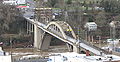 |
Highway 43 spanning the Willamette River Willamette River The Willamette River is a major tributary of the Columbia River, accounting for 12 to 15 percent of the Columbia's flow. The Willamette's main stem is long, lying entirely in northwestern Oregon in the United States... 45.35923°N 122.6098°W |
Oregon City Oregon City, Oregon Oregon City was the first city in the United States west of the Rocky Mountains to be incorporated. It is the county seat of Clackamas County, Oregon... and West Linn West Linn, Oregon West Linn is a city in Clackamas County, Oregon, United States. Now a prosperous southern suburb of Portland, West Linn has a history of early development, prompted by the opportunity to harvest energy from nearby Willamette Falls. It was named after Senator Dr. Lewis Fields Linn of Ste... |
||
| 80 | Andrew P. Wilson House | image pending | 11188 SE 27th Avenue 45.44256°N 122.6349°W |
Milwaukie Milwaukie, Oregon Milwaukie is a city in Clackamas County, Oregon, United States. A very small portion of the city extends into Multnomah County. The population was 20,291 at the 2010 census. Founded in 1848 on the banks of the Willamette River, the city, known as the Dogwood City of the West, was incorporated in... |
||
| 81 | Zigzag Ranger Station Zigzag Ranger Station The Zigzag Ranger Station is a Forest Service compound consisting of twenty rustic buildings located in Oregon’s Mount Hood National Forest. It was built as the administrative headquarters for the Zigzag Ranger District. It is located in the small unincorporated community of Zigzag, Oregon... |
 |
70220 E. U.S. Route 26 U.S. Route 26 in Oregon In the U.S. state of Oregon, U.S. Route 26 is a major cross-state state highway, connecting U.S. Route 101 on the Oregon Coast near Seaside with the Idaho state line east of Nyssa. Local highway names include the Sunset Highway No. 47, Mount Hood Highway No. 26, and John Day Highway No... 45.3429°N 121.9414°W |
Zigzag Zigzag, Oregon Zigzag is an unincorporated community in Clackamas County, Oregon, United States. It is located within the Mount Hood Corridor, between Rhododendron and Welches on U.S. Route 26... |
See also
- List of National Historic Landmarks in Oregon
- National Register of Historic Places listings in Oregon
- Listings in adjacent counties: Hood RiverNational Register of Historic Places listings in Hood River County, OregonThe following list presents the full set of National Register of Historic Places listings in Hood River County, Oregon, and offers brief descriptive information about each of them. The National Register of Historic Places recognizes buildings, structures, objects, sites, and districts of national,...
, Marion, Multnomah, WascoNational Register of Historic Places listings in Wasco County, OregonThe following list includes all of the National Register of Historic Places listings in Wasco County, Oregon, and offers brief descriptive information about each of them. The National Register of Historic Places recognizes buildings, structures, objects, sites, and districts of national, state, or...
, WashingtonNational Register of Historic Places listings in Washington County, OregonThe following list presents the full set of National Register of Historic Places listings in Washington County, Oregon, and offers brief descriptive information about each of them. The National Register of Historic Places recognizes buildings, structures, objects, sites, and districts of national,...
, Yamhill - Historic preservationHistoric preservationHistoric preservation is an endeavor that seeks to preserve, conserve and protect buildings, objects, landscapes or other artifacts of historical significance...
- History of OregonHistory of OregonThe history of Oregon, a U.S. state, may be considered in five eras: geologic history, inhabitation by native peoples, early exploration by Europeans , settlement by pioneers, and modern development....
- Lists of Oregon-related topics