

Mesoscale Convective System
Encyclopedia
Extratropical cyclone
Extratropical cyclones, sometimes called mid-latitude cyclones or wave cyclones, are a group of cyclones defined as synoptic scale low pressure weather systems that occur in the middle latitudes of the Earth having neither tropical nor polar characteristics, and are connected with fronts and...
s, and normally persists for several hours or more. A mesoscale convective system's overall cloud and precipitation pattern may be round or linear in shape, and include weather systems such as tropical cyclone
Tropical cyclone
A tropical cyclone is a storm system characterized by a large low-pressure center and numerous thunderstorms that produce strong winds and heavy rain. Tropical cyclones strengthen when water evaporated from the ocean is released as the saturated air rises, resulting in condensation of water vapor...
s, squall line
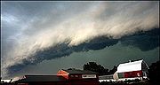
Squall line
A squall line is a line of severe thunderstorms that can form along or ahead of a cold front. In the early 20th century, the term was used as a synonym for cold front. It contains heavy precipitation, hail, frequent lightning, strong straight-line winds, and possibly tornadoes and waterspouts....
s, lake-effect snow events, polar low
Polar low
A polar low is a small-scale, long-lived atmospheric low pressure system that is found over the ocean areas poleward of the main polar front in both the Northern and Southern Hemispheres. The systems usually have a horizontal length scale of less than and exist for no more than a couple of days. ...
s, and Mesoscale Convective Complex
Mesoscale Convective Complex
A mesoscale convective complex is a unique kind of mesoscale convective system which is defined by characteristics observed in infrared satellite imagery. They are long-lived, nocturnal in formation and commonly contain heavy rainfall, wind, hail, lightning and possibly tornadoes.-Size:A...
es (MCCs), and generally form near weather front
Weather front
A weather front is a boundary separating two masses of air of different densities, and is the principal cause of meteorological phenomena. In surface weather analyses, fronts are depicted using various colored lines and symbols, depending on the type of front...
s. The type that forms during the warm season over land has been noted across North America
North America
North America is a continent wholly within the Northern Hemisphere and almost wholly within the Western Hemisphere. It is also considered a northern subcontinent of the Americas...
, Europe
Europe
Europe is, by convention, one of the world's seven continents. Comprising the westernmost peninsula of Eurasia, Europe is generally 'divided' from Asia to its east by the watershed divides of the Ural and Caucasus Mountains, the Ural River, the Caspian and Black Seas, and the waterways connecting...
, and Asia
Asia
Asia is the world's largest and most populous continent, located primarily in the eastern and northern hemispheres. It covers 8.7% of the Earth's total surface area and with approximately 3.879 billion people, it hosts 60% of the world's current human population...
, with a maximum in activity noted during the late afternoon and evening hours.
Forms of MCS that develop within the tropics use either the Intertropical Convergence Zone
Intertropical Convergence Zone
The Intertropical Convergence Zone , known by sailors as The Doldrums, is the area encircling the earth near the equator where winds originating in the northern and southern hemispheres come together....
or monsoon trough
Monsoon trough
The monsoon trough is that portion of the Intertropical Convergence Zone which extends into or through a monsoon circulation, as depicted by a line on a weather map showing the locations of minimum sea level pressure, and as such, is a convergence zone between the wind patterns of the southern and...
s as a focus for their development, generally within the warm season between spring
Spring (season)
Spring is one of the four temperate seasons, the transition period between winter and summer. Spring and "springtime" refer to the season, and broadly to ideas of rebirth, renewal and regrowth. The specific definition of the exact timing of "spring" varies according to local climate, cultures and...
and fall. One exception is that of lake-effect snow bands, which form due to cold air moving across relatively warm bodies of water, and occurs from fall through spring. Polar lows are a second special class of MCS which form at high latitudes during the cold season. Once the parent MCS dies, later thunderstorm development can occur in connection with its remnant mesoscale convective vortex
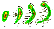
Mesoscale convective vortex
A mesoscale convective vortex is a low-pressure center within an mesoscale convective system that pulls winds into a circling pattern, or vortex. With a core only 30 to wide and 1 to deep, an MCV is often overlooked in standard weather analysis. But an MCV can take on a life of its own,...
(MCV). Mesoscale convective systems are important to the United States rainfall climatology
United States rainfall climatology
The characteristics of United States rainfall climatology differ significantly across the United States and its possessions. Late summer and fall extratropical cyclones bring a majority of the precipitation which falls across western, southern, and southeast Alaska annually...
over the Great Plains
Great Plains
The Great Plains are a broad expanse of flat land, much of it covered in prairie, steppe and grassland, which lies west of the Mississippi River and east of the Rocky Mountains in the United States and Canada. This area covers parts of the U.S...
since they bring the region about half of their annual warm season rainfall.
Definition
MesoscaleMesoscale meteorology
Mesoscale meteorology is the study of weather systems smaller than synoptic scale systems but larger than microscale and storm-scale cumulus systems. Horizontal dimensions generally range from around 5 kilometers to several hundred kilometers...
convective systems are thunderstorm regions which may be round or linear in shape, on the order of 100 kilometres (62.1 mi) or more across in one direction but smaller than extratropical cyclones, and include systems such as tropical cyclones, squall lines, and Mesoscale Convective Complexes
Mesoscale Convective Complex
A mesoscale convective complex is a unique kind of mesoscale convective system which is defined by characteristics observed in infrared satellite imagery. They are long-lived, nocturnal in formation and commonly contain heavy rainfall, wind, hail, lightning and possibly tornadoes.-Size:A...
(MCCs), among others. MCS is a more generalized term which includes systems that do not satisfy the stricter size, shape, or duration criteria of an MCC. They tend to form near weather front
Weather front
A weather front is a boundary separating two masses of air of different densities, and is the principal cause of meteorological phenomena. In surface weather analyses, fronts are depicted using various colored lines and symbols, depending on the type of front...
s and move into areas of 1000-500 mb thickness diffluence, which are areas where the low to mid level temperature gradient broadens, which generally steers the thunderstorm clusters into the warm sector of extratropical cyclone
Extratropical cyclone
Extratropical cyclones, sometimes called mid-latitude cyclones or wave cyclones, are a group of cyclones defined as synoptic scale low pressure weather systems that occur in the middle latitudes of the Earth having neither tropical nor polar characteristics, and are connected with fronts and...
s, or equatorward of warm front
Warm front
A warm front is a density discontinuity located at the leading edge of a homogeneous warm air mass, and is typically located on the equator-facing edge of an isotherm gradient...
s. They can also form along any convergent zones within the tropics. Their formation has been noted worldwide, from the Mei-Yu front in the far East to the deep tropics. Mesoscale convective systems are important to the United States rainfall climatology
United States rainfall climatology
The characteristics of United States rainfall climatology differ significantly across the United States and its possessions. Late summer and fall extratropical cyclones bring a majority of the precipitation which falls across western, southern, and southeast Alaska annually...
over the Great Plains
Great Plains
The Great Plains are a broad expanse of flat land, much of it covered in prairie, steppe and grassland, which lies west of the Mississippi River and east of the Rocky Mountains in the United States and Canada. This area covers parts of the U.S...
since they bring the region about half of their annual warm season rainfall.
Mesoscale Convective Complex
A mesoscale convective complex (MCC) is a unique kind of mesoscale convective system which is defined by characteristics observed in infrared satellite imagerySatellite imagery
Satellite imagery consists of photographs of Earth or other planets made by means of artificial satellites.- History :The first images from space were taken on sub-orbital flights. The U.S-launched V-2 flight on October 24, 1946 took one image every 1.5 seconds...
. Their area of cold cloud tops exceeds 100000 square kilometre with temperature less than or equal to -32 C; and an area of cloud top of 50000 square kilometre with temperature less than or equal to -52 C. Size definitions must be met for six hours or greater. Its maximum extent is defined as when the cloud shield, or the overall cloud formation, reaches its maximum area. Its eccentricity
Eccentricity (mathematics)
In mathematics, the eccentricity, denoted e or \varepsilon, is a parameter associated with every conic section. It can be thought of as a measure of how much the conic section deviates from being circular.In particular,...
(minor axis/major axis) is greater than or equal to 0.7 at maximum extent, so they are fairly round. They are long-lived, nocturnal in formation as they tend to form overnight, and commonly contain heavy rainfall, wind, hail
Hail
Hail is a form of solid precipitation. It consists of balls or irregular lumps of ice, each of which is referred to as a hail stone. Hail stones on Earth consist mostly of water ice and measure between and in diameter, with the larger stones coming from severe thunderstorms...
, lightning
Lightning
Lightning is an atmospheric electrostatic discharge accompanied by thunder, which typically occurs during thunderstorms, and sometimes during volcanic eruptions or dust storms...
and possibly tornado
Tornado
A tornado is a violent, dangerous, rotating column of air that is in contact with both the surface of the earth and a cumulonimbus cloud or, in rare cases, the base of a cumulus cloud. They are often referred to as a twister or a cyclone, although the word cyclone is used in meteorology in a wider...
es.
Squall line
A squall line is an elongated line of severe thunderstorms that can form along and/or ahead of a cold front
Cold front
A cold front is defined as the leading edge of a cooler mass of air, replacing a warmer mass of air.-Development of cold front:The cooler and denser air wedges under the less-dense warmer air, lifting it...
. In the early 20th century, the term was used as a synonym for cold front
Cold front
A cold front is defined as the leading edge of a cooler mass of air, replacing a warmer mass of air.-Development of cold front:The cooler and denser air wedges under the less-dense warmer air, lifting it...
. The squall line contains heavy precipitation
Precipitation (meteorology)
In meteorology, precipitation In meteorology, precipitation In meteorology, precipitation (also known as one of the classes of hydrometeors, which are atmospheric water phenomena is any product of the condensation of atmospheric water vapor that falls under gravity. The main forms of precipitation...
, hail
Hail
Hail is a form of solid precipitation. It consists of balls or irregular lumps of ice, each of which is referred to as a hail stone. Hail stones on Earth consist mostly of water ice and measure between and in diameter, with the larger stones coming from severe thunderstorms...
, frequent lightning
Lightning
Lightning is an atmospheric electrostatic discharge accompanied by thunder, which typically occurs during thunderstorms, and sometimes during volcanic eruptions or dust storms...
, strong straight line wind
Wind
Wind is the flow of gases on a large scale. On Earth, wind consists of the bulk movement of air. In outer space, solar wind is the movement of gases or charged particles from the sun through space, while planetary wind is the outgassing of light chemical elements from a planet's atmosphere into space...
s, and possibly tornado
Tornado
A tornado is a violent, dangerous, rotating column of air that is in contact with both the surface of the earth and a cumulonimbus cloud or, in rare cases, the base of a cumulus cloud. They are often referred to as a twister or a cyclone, although the word cyclone is used in meteorology in a wider...
es and waterspouts. Severe weather
Severe weather
Severe weather phenomena are weather conditions that are hazardous to human life and property.- Examples Include :Severe weather can occur under a variety of situations, but three characteristics are generally needed: a temperature or moisture boundary, moisture, and , instability in the...
, in form of strong straight-line winds can be expected in areas where the squall line itself is in the shape of a bow echo
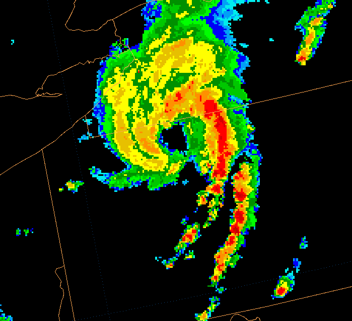
Bow echo
A bow echo is a term describing the characteristic radar return from a mesoscale convective system that is shaped like an archer’s bow. These systems can produce severe straight-line winds and occasionally tornadoes, causing major damage.-Research:...
, within the portion of the line which bows out the most. Tornado
Tornado
A tornado is a violent, dangerous, rotating column of air that is in contact with both the surface of the earth and a cumulonimbus cloud or, in rare cases, the base of a cumulus cloud. They are often referred to as a twister or a cyclone, although the word cyclone is used in meteorology in a wider...
es can be found along waves within a line echo wave pattern, or LEWP, where mesoscale low pressure area
Low pressure area
A low-pressure area, or "low", is a region where the atmospheric pressure at sea level is below that of surrounding locations. Low-pressure systems form under areas of wind divergence which occur in upper levels of the troposphere. The formation process of a low-pressure area is known as...
s are present. Some bow echoes which develop within the summer season are known as derecho
Derecho
A derecho is a widespread and long-lived, violent convectively induced straight-line windstorm that is associated with a fast-moving band of severe thunderstorms in the form of a squall line usually taking the form of a bow echo...
s, and they move quite fast through large sections of territory. On the back edge of the rain shield associated with mature squall lines, a wake low
Wake low
A wake low, or wake depression, is a mesoscale low-pressure area which trails the mesoscale high following a squall line. Due to the subsiding warm air associated with the systems formation, clearing skies are associated with the wake low...
can form, which is a mesoscale low pressure area that forms behind the mesoscale high pressure system normally present under the rain canopy, which are sometimes associated with a heat burst
Heat burst
In meteorology, a heat burst is a rare atmospheric phenomenon characterised by gusty winds and a rapid increase in temperature and decrease in dew point...
.
Tropical cyclone

A tropical cyclone is a fairly symmetric storm system
Storm
A storm is any disturbed state of an astronomical body's atmosphere, especially affecting its surface, and strongly implying severe weather...
characterized by a low pressure center and numerous thunderstorms that produce strong winds and flood
Flood
A flood is an overflow of an expanse of water that submerges land. The EU Floods directive defines a flood as a temporary covering by water of land not normally covered by water...
ing rain. A tropical cyclone feeds on the heat released when moist air rises, resulting in condensation
Condensation
Condensation is the change of the physical state of matter from gaseous phase into liquid phase, and is the reverse of vaporization. When the transition happens from the gaseous phase into the solid phase directly, the change is called deposition....
of water vapour contained in the moist air. It is fueled by a different heat mechanism than other cyclonic windstorms such as nor'easter
Nor'easter
A nor'easter is a type of macro-scale storm along the East Coast of the United States and Atlantic Canada, so named because the storm travels to the northeast from the south and the winds come from the northeast, especially in the coastal areas of the Northeastern United States and Atlantic Canada...
s, European windstorm
European windstorm
A European windstorm is a severe cyclonic windstorm associated with areas of low atmospheric pressure that track across the North Atlantic towards northwestern Europe. They are most common in the winter months...
s, and polar low
Polar low
A polar low is a small-scale, long-lived atmospheric low pressure system that is found over the ocean areas poleward of the main polar front in both the Northern and Southern Hemispheres. The systems usually have a horizontal length scale of less than and exist for no more than a couple of days. ...
s, leading to their classification as "warm core" storm systems.
The term "tropical" refers to both the geographic origin of these systems, which form often in tropical
Tropics
The tropics is a region of the Earth surrounding the Equator. It is limited in latitude by the Tropic of Cancer in the northern hemisphere at approximately N and the Tropic of Capricorn in the southern hemisphere at S; these latitudes correspond to the axial tilt of the Earth...
regions of the globe, and their formation in Maritime Tropical air masses. The term "cyclone" refers to such storms' cyclonic nature, with counterclockwise rotation in the Northern Hemisphere
Northern Hemisphere
The Northern Hemisphere is the half of a planet that is north of its equator—the word hemisphere literally means “half sphere”. It is also that half of the celestial sphere north of the celestial equator...
and clockwise rotation in the Southern Hemisphere
Southern Hemisphere
The Southern Hemisphere is the part of Earth that lies south of the equator. The word hemisphere literally means 'half ball' or "half sphere"...
. Depending on their location and strength, tropical cyclones are referred to by other names, such as hurricane, typhoon, tropical storm, cyclonic storm, tropical depression, or simply as a cyclone. Generally speaking, a tropical cyclone is referred to as a hurricane (from the name of the ancient Central American deity of wind, Huracan
Huracan
Huracan , in Mayan understandable as Jun Raqan "one legged", is a K'iche' Mayan god of wind, storm, fire and one of the creator deities who participated in all three attempts at creating humanity...
) in the Atlantic and eastern Pacific oceans, a typhoon across the northwest Pacific ocean, and a cyclone across in the southern hemisphere and Indian ocean.
Tropical cyclones can produce extremely powerful winds and torrential rain, as well as high waves and damaging storm surge
Storm surge
A storm surge is an offshore rise of water associated with a low pressure weather system, typically tropical cyclones and strong extratropical cyclones. Storm surges are caused primarily by high winds pushing on the ocean's surface. The wind causes the water to pile up higher than the ordinary sea...
. They develop over large bodies of warm water, and lose their strength if they move over land. This is the reason coastal regions can receive significant damage from a tropical cyclone, while inland regions are relatively safe from the strong winds. Heavy rains, however, can produce significant flooding inland, and storm surges can produce extensive coastal flooding up to 40 kilometres (24.9 mi) from the coastline. Although their effects on human populations can be devastating, tropical cyclones can also relieve drought
Drought
A drought is an extended period of months or years when a region notes a deficiency in its water supply. Generally, this occurs when a region receives consistently below average precipitation. It can have a substantial impact on the ecosystem and agriculture of the affected region...
conditions. They also carry heat and energy away from the tropics and transport it toward temperate
Temperate
In geography, temperate or tepid latitudes of the globe lie between the tropics and the polar circles. The changes in these regions between summer and winter are generally relatively moderate, rather than extreme hot or cold...
latitudes, which makes them an important part of the global atmospheric circulation
Atmospheric circulation
Atmospheric circulation is the large-scale movement of air, and the means by which thermal energy is distributed on the surface of the Earth....
mechanism. As a result, tropical cyclones help to maintain equilibrium in the Earth's troposphere
Troposphere
The troposphere is the lowest portion of Earth's atmosphere. It contains approximately 80% of the atmosphere's mass and 99% of its water vapor and aerosols....
, and to maintain a relatively stable and warm.
Many tropical cyclones develop
Tropical cyclogenesis
Tropical cyclogenesis is the term that describes the development and strengthening of a tropical cyclone in the atmosphere. The mechanisms through which tropical cyclogenesis occurs are distinctly different from those through which mid-latitude cyclogenesis occurs...
when the atmospheric conditions around a weak disturbance in the atmosphere are favorable. Others form when other types of cyclones acquire tropical characteristics. Tropical systems are then moved by steering winds in the troposphere
Troposphere
The troposphere is the lowest portion of Earth's atmosphere. It contains approximately 80% of the atmosphere's mass and 99% of its water vapor and aerosols....
; if the conditions remain favorable, the tropical disturbance intensifies, and can even develop an eye
Eye (cyclone)
The eye is a region of mostly calm weather found at the center of strong tropical cyclones. The eye of a storm is a roughly circular area and typically 30–65 km in diameter. It is surrounded by the eyewall, a ring of towering thunderstorms where the second most severe weather of a cyclone...
. On the other end of the spectrum, if the conditions around the system deteriorate or the tropical cyclone makes landfall, the system weakens and eventually dissipates. A tropical cyclone can become extratropical as it moves toward higher latitudes if its energy source changes from heat released by condensation to differences in temperature between air masses; From an operational standpoint, a tropical cyclone is usually not considered to become a subtropical cyclone
Subtropical cyclone
A subtropical cyclone is a weather system that has some characteristics of a tropical and an extratropical cyclone. As early as the 1950s, meteorologists were unclear whether they should be characterized as tropical or extratropical cyclones. They were officially recognized by the National...
during its extratropical transition.
Lake-effect snow

Lake-effect snow is produced in the winter in the shape of one or more elongated bands when cold winds move across long expanses of warmer lake water, providing energy and picking up water vapor
Water vapor
Water vapor or water vapour , also aqueous vapor, is the gas phase of water. It is one state of water within the hydrosphere. Water vapor can be produced from the evaporation or boiling of liquid water or from the sublimation of ice. Under typical atmospheric conditions, water vapor is continuously...
which freezes and is deposited on the lee shore
Lee shore
The terms lee shore and windweather or ward shore are nautical terms used to describe a stretch of shoreline. A lee shore is one that is to the lee side of a vessel - meaning the wind is blowing towards it. A weather shore has the wind blowing from inland over it out to sea...
s. The same effect over bodies of salt water is called ocean effect snow, sea effect snow, or even bay effect snow. The effect is enhanced when the moving air mass is uplifted by the orographic
Orographic lift
Orographic lift occurs when an air mass is forced from a low elevation to a higher elevation as it moves over rising terrain. As the air mass gains altitude it quickly cools down adiabatically, which can raise the relative humidity to 100% and create clouds and, under the right conditions,...
effect of higher elevations on the downwind shores. This uplifting can produce narrow, but very intense bands of precipitation, which is deposited at a rate of many inches of snow per hour and often brings copious snowfall totals. The areas affected by lake-effect snow are called snowbelt
Snowbelt
Snowbelt is a term describing of a number of regions near the Great Lakes in North America where heavy snowfall in the form of lake-effect snow is particularly common. Snowbelts are typically found downwind of the lakes, principally off the eastern and southern shores...
s. This effect occurs in many locations throughout the world, but is best known in the populated areas of the Great Lakes
Great Lakes
The Great Lakes are a collection of freshwater lakes located in northeastern North America, on the Canada – United States border. Consisting of Lakes Superior, Michigan, Huron, Erie, and Ontario, they form the largest group of freshwater lakes on Earth by total surface, coming in second by volume...
of North America
North America
North America is a continent wholly within the Northern Hemisphere and almost wholly within the Western Hemisphere. It is also considered a northern subcontinent of the Americas...
.
If the air temperature is not low enough to keep the precipitation frozen, it falls as lake-effect rain. In order for lake-effect rain or snow to form, the air moving across the lake must be significantly cooler than the surface air (which is likely to be near the temperature of the water surface). Specifically, the air temperature at the altitude where the air pressure is 850 millibars (or 1.5 kilometre (0.93205910497471 mi) altitude) should be 13 °C (24 °F) lower than the temperature of the air at the surface. Lake-effect occurring when the air at 850 millibars is 25 °C (45 °F) colder than the water temperature can produce thundersnow
Thundersnow
Thundersnow, also known as a winter thunderstorm or a thunder snowstorm, is a relatively rare kind of thunderstorm with snow falling as the primary precipitation instead of rain. It typically falls in regions of strong upward motion within the cold sector of an extratropical cyclone...
, snow showers accompanied by lightning and thunder
Thunder
Thunder is the sound made by lightning. Depending on the nature of the lightning and distance of the listener, thunder can range from a sharp, loud crack to a long, low rumble . The sudden increase in pressure and temperature from lightning produces rapid expansion of the air surrounding and within...
(due to the larger amount of energy available from the increased instability).
Polar low
A polar low is a small-scale, symmetric, short-lived atmospheric low pressure systemLow pressure area
A low-pressure area, or "low", is a region where the atmospheric pressure at sea level is below that of surrounding locations. Low-pressure systems form under areas of wind divergence which occur in upper levels of the troposphere. The formation process of a low-pressure area is known as...
(depression) that is found over the ocean areas poleward of the main polar front
Polar front
In meteorology, the polar front is the boundary between the polar cell and the Ferrel cell in each hemisphere. At this boundary a sharp gradient in temperature occurs between these two air masses, each at very different temperatures....
in both the Northern and Southern Hemispheres. The systems usually have a horizontal length scale of less than 1000 kilometres (621.4 mi) and exist for no more than a couple of days. They are part of the larger class of mesoscale
Mesoscale meteorology
Mesoscale meteorology is the study of weather systems smaller than synoptic scale systems but larger than microscale and storm-scale cumulus systems. Horizontal dimensions generally range from around 5 kilometers to several hundred kilometers...
weather systems. Polar lows can be difficult to detect using conventional weather reports and are a hazard to high-latitude operations, such as shipping and gas and oil platforms. Polar lows have been referred to by many other terms, such as polar mesoscale vortex, Arctic hurricane, Arctic low, and cold air depression. Today the term is usually reserved for the more vigorous systems that have near-surface winds of at least 17 metres per second (38 mph).
Great Plains of the United States
Europe
While most form over the continent, some MCSs form during the second half of August and September over the western Mediterranean SeaMediterranean Sea
The Mediterranean Sea is a sea connected to the Atlantic Ocean surrounded by the Mediterranean region and almost completely enclosed by land: on the north by Anatolia and Europe, on the south by North Africa, and on the east by the Levant...
. MCS triggering over Europe is strongly tied to mountain ranges. On average, a European MCS moves east-northeast, forming near 3 p.m. local solar time
Solar time
Solar time is a reckoning of the passage of time based on the Sun's position in the sky. The fundamental unit of solar time is the day. Two types of solar time are apparent solar time and mean solar time .-Introduction:...
, lasts 5.5 hours, dissipating near 9 p.m. LST. Around 20% of the MCSs over Europe do not form during maximum heating. Their average maximum extent is around 9000 square kilometre.
Tropics
Mesoscale convective systems, which can evolve into tropical cyclones, form along areas such as tropical waveTropical wave
Tropical waves, easterly waves, or tropical easterly waves, also known as African easterly waves in the Atlantic region, are a type of atmospheric trough, an elongated area of relatively low air pressure, oriented north to south, which move from east to west across the tropics causing areas of...
s or easterly waves which progress westward along monsoon troughs and the Intertropical Convergence Zone in regions of ample low level moisture, convergent surface winds, and divergent winds aloft. This typically occurs north of the equator
Equator
An equator is the intersection of a sphere's surface with the plane perpendicular to the sphere's axis of rotation and containing the sphere's center of mass....
from Africa
Africa
Africa is the world's second largest and second most populous continent, after Asia. At about 30.2 million km² including adjacent islands, it covers 6% of the Earth's total surface area and 20.4% of the total land area...
across the Atlantic
Atlantic Ocean
The Atlantic Ocean is the second-largest of the world's oceanic divisions. With a total area of about , it covers approximately 20% of the Earth's surface and about 26% of its water surface area...
and eastern Pacific ocean
Pacific Ocean
The Pacific Ocean is the largest of the Earth's oceanic divisions. It extends from the Arctic in the north to the Southern Ocean in the south, bounded by Asia and Australia in the west, and the Americas in the east.At 165.2 million square kilometres in area, this largest division of the World...
s, as well as across the northwest and southwest Pacific oceans, from Australia
Australia
Australia , officially the Commonwealth of Australia, is a country in the Southern Hemisphere comprising the mainland of the Australian continent, the island of Tasmania, and numerous smaller islands in the Indian and Pacific Oceans. It is the world's sixth-largest country by total area...
eastward into Oceania
Oceania
Oceania is a region centered on the islands of the tropical Pacific Ocean. Conceptions of what constitutes Oceania range from the coral atolls and volcanic islands of the South Pacific to the entire insular region between Asia and the Americas, including Australasia and the Malay Archipelago...
, the Indian ocean
Indian Ocean
The Indian Ocean is the third largest of the world's oceanic divisions, covering approximately 20% of the water on the Earth's surface. It is bounded on the north by the Indian Subcontinent and Arabian Peninsula ; on the west by eastern Africa; on the east by Indochina, the Sunda Islands, and...
, Indonesia
Indonesia
Indonesia , officially the Republic of Indonesia , is a country in Southeast Asia and Oceania. Indonesia is an archipelago comprising approximately 13,000 islands. It has 33 provinces with over 238 million people, and is the world's fourth most populous country. Indonesia is a republic, with an...
, and from southeast Brazil
Brazil
Brazil , officially the Federative Republic of Brazil , is the largest country in South America. It is the world's fifth largest country, both by geographical area and by population with over 192 million people...
into the southern Atlantic ocean. It is also noted on occasion in the southeast Pacific ocean mild to cool ENSO
Enso
Ensō is a Japanese word meaning "circle" and a concept strongly associated with Zen. Ensō is one of the most common subjects of Japanese calligraphy even though it is a symbol and not a character. It symbolizes the Absolute enlightenment, strength, elegance, the Universe, and the void; it can...
years, outside of El Niño. More intense systems form over land than water.
Lee of warm water bodies in the winter
In the cases of Lake-effect snow and polar lows, the convective systems form over warm water bodies when cold air sweeps over their surface and leads to an increase in moisture and significant vertical motion. This vertical motion leads to the development of showers and thunderstorms in areas of cyclonic flow on the backside of extratropical cycloneExtratropical cyclone
Extratropical cyclones, sometimes called mid-latitude cyclones or wave cyclones, are a group of cyclones defined as synoptic scale low pressure weather systems that occur in the middle latitudes of the Earth having neither tropical nor polar characteristics, and are connected with fronts and...
s.
Their remnants
A mesoscale convective vortex (MCV) is a mid-level low-pressure center within an MCS that pulls winds into a circling pattern, or vortex. Once the parent MCS dies, this vortex can persist and lead to future convective development. With a core only 30 miles (48.3 km) to 60 miles (96.6 km) and up to 8 kilometres (5 mi) deep, an MCV can occasionally spawn a mesoscale surface low pressure area which appears on mesoscale surface weather analysesSurface weather analysis
Surface weather analysis is a special type of weather map that provides a view of weather elements over a geographical area at a specified time based on information from ground-based weather stations...
. But an MCV can take on a life of its own, persisting for up to several days after its parent MCS has dissipated. The orphaned MCV will sometimes then become the seed of the next thunderstorm outbreak. An MCV that moves into tropical waters, such as the Gulf of Mexico
Gulf of Mexico
The Gulf of Mexico is a partially landlocked ocean basin largely surrounded by the North American continent and the island of Cuba. It is bounded on the northeast, north and northwest by the Gulf Coast of the United States, on the southwest and south by Mexico, and on the southeast by Cuba. In...
, can serve as the nucleus for a tropical storm or hurricane.
External links
- Mesoscale convective system (AMS Glossary of Meteorology)