

McCreary County, Kentucky
Encyclopedia
McCreary County is a county located in the U.S. state
of Kentucky
. As of 2000, the population was 17,080. Its county seat
is Whitley City
. The county is named for James B. McCreary
, a Confederate war hero and Governor of Kentucky
from 1875 to 1879. It is the only Kentucky county to not have a single incorporated city. Because of this, county government is the sole local government agency for the entire county. Attractions in McCreary County include the Big South Fork National River and Recreation Area
, Cumberland Falls
State Park, and the Big South Fork Scenic Railway
, which tours several former coal camps.
The majority of the county is owned by the federal government. 63% is owned and managed by the Daniel Boone National Forest
, and 18% owned and managed by the National Park Service
as the Big South Fork National River and Recreation Area
.
and Whitley
Counties, with a large center strip following the rail line and roadway from Pulaski County
. The early history of the area is that of those counties, and is related in the historic perspectives for them. The map to the left shows the network of roadways that had been established by the 1860s. A dotted blue line and settlement names have been added for reference.
The most significant early feature of the future county was the Jacksboro Road. Running from Jacksboro, Tennessee
, to Point Isabel and Somerset
, this pioneer road was simply an enlargement of the Tellico Trail, an Indian route that had been used for thousands of years. Several other trails intersected this road, and led to the growth settlement villages such as Pine Knot
, Dripping Springs/Coolidge, and Flat Rock. Other settlement occurred in far flung, sequestered hollows. The economy of the times was based upon small-scale subsistence agriculture
, timber products
such as railroad ties and barrel staves, and small coal mines
.
Beginning in the early 19th century, Cumberland Falls
gained attention as an early tourism destination. Later development increased visitation, and the Brunsen Inn was a popular destination for seasonal visitors. Until a road was built from Whitley County
in 1931, the primary access to the Falls what through McCreary. With a generous contribution from one of the DuPont
family heirs, the Falls joined the state park system in 1930.
The completion of the Cincinnati Southern Railway line through the county in 1880 changed its economic characteristics forever. Access to distant markets for timber and coal caused the emergence of many small mining and logging companies. Nothing however, was to have the impact of the Justus S. Stearns enterprises. From 1903 throughout most of the 20th century, the territory of McCreary County was dominated and controlled by Stearns company interests.
Attempting to avoid financial losses during the Great Depression
of the 1930s, the Stearns cluster of companies sold vast quantities of land to the U.S. Government, becoming part of what was to become the Cumberland National Forest in 1937. This forest reserve was subsequently renamed Daniel Boone National Forest
. In the 1970s, legislative action acquired additional lands in southern McCreary and Tennessee
, creating the Big South Fork National River and Recreation Area
in the mid-1970s.
 The western boundary of McCreary County represents the division between two geological plateau systems, the Pennyroyal
and the Cumberland
, which are located in the Mississippian
Plateau and the Eastern Coal Field
respectively. Running diagonally along the Wayne-McCreary County line and through southern Pulaski County
is the Pottsville Escarpment
. This rugged strip of land is the dividing feature separating the geologically younger Eastern Kentucky Coal Field
region from the older, western geology of the state. It is a sandstone
belt of cliffs and steep sided, narrow crested valleys. It is located in the Daniel Boone National Forest
.
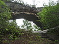
Among the more spectacular features are the sheer cliffs themselves, and numerous gorges
, waterfalls, rock shelters, and natural stone arches
. Two of the best known sections of the escarpment in Kentucky are the Red River Gorge
Geological Area and the Natural Bridge State Park
in the north-central portion of the Daniel Boone National Forest.
McCreary and the southern reaches of Pulaski County represent the beginnings of the Cumberland Plateau and the Eastern Kentucky Coal Field region. Most of the geological underpinning of this region is capped with thick sandstone, and formidable coal seams are common in this formation. The terrain is sharply dissected by valleys and stream systems, and limited lands suitable for large-scale conventional agriculture exist. Because of this, the economies of the area have historically been centered upon extractive industries such as timber
and mining
.
and timber
. The Stearns interests sold the last of their mining operations to Blue Diamond Coal in the 1980s, and the last mine operating in the county closed in 1994. A resurgence of the coal industry does not seem possible, as the local coal is high in sulfur
, and drainage from coal mining
would adversely affect a number of outstanding and special waters in the county.
Industrial development began in the 1970s, with new manufacturing concerns in the sewing industry
. Changes in the global economy have shifted a substantial percentage of the consumer garment market to production facilities outside the United States. Those that remain in the county draw their work from military contracts, and the production of high-end consumer goods. Timber remains a factor in the economy, with logging and cut hardwood production. Since the 1970s, the county has attempted to develop three industrial parks with little success. The latest venture, on Kentucky Route 92
in Pine Knot, is building a "spec" building as a means of attracting new industry to the county.
Agriculture has never played an important role in the county’s economy. In 2002, 5% of the county was in farmland. Top products were livestock
, hay
and forage
. Together this represented a total market value of $566,000, down 1% from 1997. These low numbers are because the county has never had a substantial agricultural industry, and that over 80% of the county lands are held by the federal government. McCreary County is ranked number 112 out of 120 counties in overall agricultural production.
The tourism industry in the county may trace its beginnings to the restoration of Historic Stearns, the development of the scenic railway, the interpretive work at Blue Heron
, and the reconstruction of Barthell
, the site of Stearns Company's first coal mine and town in 1903. Those resources may represent the largest interpretive collection of historic coal mining in America. The Big South Fork Scenic Railway
is presently in a major development project to add a steam locomotive
and extend the line.
The Big South Fork NRRA
represents 196 square miles (508 km²) of land, of which approximately one-third is located in McCreary County. The largest section of the park and its main Bandy Creek visitor center are located in Tennessee
. In 2004, the park received 901,425 visitors, down 23% from 2002. Due to a lack of organized activities, events, and recreational tourism
opportunities, visitation on the Kentucky side does not fare well. Similar issues exist for visitation in the Stearns
and Somerset
districts of the Daniel Boone National Forest
.
is located in the county, near Pine Knot
.
of 2000, there were 17,080 people, 6,520 households, and 4,753 families residing in the county. The population density
was 40 /sqmi. There were 7,405 housing units at an average density of 17 /sqmi. The racial makeup of the county was 97.99% White
, 0.63% Black or African American
, 0.42% Native American
, 0.02% Asian
, 0.01% Pacific Islander
, 0.20% from other races, and 0.73% from two or more races. 0.62% of the population were Hispanics or Latinos
of any race.
There were 6,520 households out of which 35.70% had children under the age of 18 living with them, 54.50% were married couples
living together, 13.80% had a female householder with no husband present, and 27.10% were non-families. 24.70% of all households were made up of individuals and 8.40% had someone living alone who was 65 years of age or older. The average household size was 2.55 and the average family size was 3.03.
The age distribution was 27.70% under the age of 18, 9.80% from 18 to 24, 28.20% from 25 to 44, 23.70% from 45 to 64, and 10.60% who were 65 years of age or older. The median age was 34 years. For every 100 females there were 96.90 males. For every 100 females age 18 and over, there were 93.80 males.
The median income for a household in the county was $19,348, and the median income for a family was $22,261. Males had a median income of $20,823 versus $15,575 for females. The per capita income
for the county was $9,896. About 26.10% of families and 32.20% of the population were below the poverty line, including 40.50% of those under age 18 and 27.30% of those age 65 or over. The county's per-capita income
makes it one of the poorest counties in the United States, and second only to another county in the same Kentucky region
, Clay County
, among counties with a majority non-Hispanic white population.
U.S. Penitentiary, McCreary is in the county, near Pine Knot
.
Also: there is Revelo, Stearns, Sawyer, Honeybee, Dixie and Strunk.
U.S. state
A U.S. state is any one of the 50 federated states of the United States of America that share sovereignty with the federal government. Because of this shared sovereignty, an American is a citizen both of the federal entity and of his or her state of domicile. Four states use the official title of...
of Kentucky
Kentucky
The Commonwealth of Kentucky is a state located in the East Central United States of America. As classified by the United States Census Bureau, Kentucky is a Southern state, more specifically in the East South Central region. Kentucky is one of four U.S. states constituted as a commonwealth...
. As of 2000, the population was 17,080. Its county seat
County seat
A county seat is an administrative center, or seat of government, for a county or civil parish. The term is primarily used in the United States....
is Whitley City
Whitley City, Kentucky
Whitley City is a census-designated place in McCreary County, Kentucky, United States. The population was 1,111 at the 2000 census. Despite its name, it is not an incorporated city; however, it is the county seat of McCreary County. Whitley City is one of two non-city county seats in Kentucky the...
. The county is named for James B. McCreary
James B. McCreary
James Bennett McCreary was a lawyer and politician from the US state of Kentucky. He represented the state in both houses of the U.S. Congress and served as its 27th and 37th governor...
, a Confederate war hero and Governor of Kentucky
Governor of Kentucky
The Governor of the Commonwealth of Kentucky is the head of the executive branch of government in the U.S. state of Kentucky. Fifty-six men and one woman have served as Governor of Kentucky. The governor's term is four years in length; since 1992, incumbents have been able to seek re-election once...
from 1875 to 1879. It is the only Kentucky county to not have a single incorporated city. Because of this, county government is the sole local government agency for the entire county. Attractions in McCreary County include the Big South Fork National River and Recreation Area
Big South Fork National River and Recreation Area
The Big South Fork National River and Recreation Area preserves the Big South Fork of the Cumberland River and its tributaries in northeastern Tennessee and southeastern Kentucky...
, Cumberland Falls
Cumberland Falls
Cumberland Falls, sometimes called the Little Niagara, the Niagara of the South, or the Great Falls, is a large waterfall on the Cumberland River in southeastern Kentucky...
State Park, and the Big South Fork Scenic Railway
Big South Fork Scenic Railway
The Big South Fork Scenic Railway is a heritage railroad in Stearns, Kentucky.The route runs for 16 miles through lush countryside in the Appalachian Mountains. Live music usually precedes train departures. The terminus is the Big South Fork River and Recreation Area...
, which tours several former coal camps.
The majority of the county is owned by the federal government. 63% is owned and managed by the Daniel Boone National Forest
Daniel Boone National Forest
Daniel Boone National Forest is the only national forest completely within the boundary of Kentucky. Established in 1937, it was originally named the Cumberland National Forest, after the core region called the Cumberland Purchase Unit...
, and 18% owned and managed by the National Park Service
National Park Service
The National Park Service is the U.S. federal agency that manages all national parks, many national monuments, and other conservation and historical properties with various title designations...
as the Big South Fork National River and Recreation Area
Big South Fork National River and Recreation Area
The Big South Fork National River and Recreation Area preserves the Big South Fork of the Cumberland River and its tributaries in northeastern Tennessee and southeastern Kentucky...
.
History
McCreary County was formed in 1912, the final county in order of formation. The present county boundaries contain 427.7 square miles (1,107.7 km²) of land area. The majority of the county was carved out of WayneWayne County, Kentucky
Wayne County is a county located in the U.S. state of Kentucky. As of 2000, the population was 19,923. Its county seat is Monticello. The county was named for Gen. Anthony Wayne. It is a prohibition or dry county.-History:...
and Whitley
Whitley County, Kentucky
Whitley County is a county located in the state of Kentucky. 2005 census projections list its population at 38,029 . The county seat is at Williamsburg, though the largest city is Corbin, and the county's District Court sits in both cities...
Counties, with a large center strip following the rail line and roadway from Pulaski County
Pulaski County, Kentucky
Pulaski County is a county located in the U.S. state of Kentucky. The population was 63,063 in the 2010 Census. Its county seat is Somerset6. The county is named for Count Kazimierz Pułaski. Most of the county is a prohibition or dry county...
. The early history of the area is that of those counties, and is related in the historic perspectives for them. The map to the left shows the network of roadways that had been established by the 1860s. A dotted blue line and settlement names have been added for reference.
The most significant early feature of the future county was the Jacksboro Road. Running from Jacksboro, Tennessee
Jacksboro, Tennessee
Jacksboro is a town in Campbell County, Tennessee, United States. The population was 1,887 at the 2000 census. It is the county seat of Campbell County.-Geography:Jacksboro is located at...
, to Point Isabel and Somerset
Somerset
The ceremonial and non-metropolitan county of Somerset in South West England borders Bristol and Gloucestershire to the north, Wiltshire to the east, Dorset to the south-east, and Devon to the south-west. It is partly bounded to the north and west by the Bristol Channel and the estuary of the...
, this pioneer road was simply an enlargement of the Tellico Trail, an Indian route that had been used for thousands of years. Several other trails intersected this road, and led to the growth settlement villages such as Pine Knot
Pine Knot, Kentucky
Pine Knot is a census-designated place in McCreary County, Kentucky, United States. The population was 1,680 at the 2000 census.-Geography:Pine Knot is located at ....
, Dripping Springs/Coolidge, and Flat Rock. Other settlement occurred in far flung, sequestered hollows. The economy of the times was based upon small-scale subsistence agriculture
Subsistence agriculture
Subsistence agriculture is self-sufficiency farming in which the farmers focus on growing enough food to feed their families. The typical subsistence farm has a range of crops and animals needed by the family to eat and clothe themselves during the year. Planting decisions are made with an eye...
, timber products
Logging
Logging is the cutting, skidding, on-site processing, and loading of trees or logs onto trucks.In forestry, the term logging is sometimes used in a narrow sense concerning the logistics of moving wood from the stump to somewhere outside the forest, usually a sawmill or a lumber yard...
such as railroad ties and barrel staves, and small coal mines
Coal mining
The goal of coal mining is to obtain coal from the ground. Coal is valued for its energy content, and since the 1880s has been widely used to generate electricity. Steel and cement industries use coal as a fuel for extraction of iron from iron ore and for cement production. In the United States,...
.
Beginning in the early 19th century, Cumberland Falls
Cumberland Falls
Cumberland Falls, sometimes called the Little Niagara, the Niagara of the South, or the Great Falls, is a large waterfall on the Cumberland River in southeastern Kentucky...
gained attention as an early tourism destination. Later development increased visitation, and the Brunsen Inn was a popular destination for seasonal visitors. Until a road was built from Whitley County
Whitley County, Kentucky
Whitley County is a county located in the state of Kentucky. 2005 census projections list its population at 38,029 . The county seat is at Williamsburg, though the largest city is Corbin, and the county's District Court sits in both cities...
in 1931, the primary access to the Falls what through McCreary. With a generous contribution from one of the DuPont
DuPont
E. I. du Pont de Nemours and Company , commonly referred to as DuPont, is an American chemical company that was founded in July 1802 as a gunpowder mill by Eleuthère Irénée du Pont. DuPont was the world's third largest chemical company based on market capitalization and ninth based on revenue in 2009...
family heirs, the Falls joined the state park system in 1930.
The completion of the Cincinnati Southern Railway line through the county in 1880 changed its economic characteristics forever. Access to distant markets for timber and coal caused the emergence of many small mining and logging companies. Nothing however, was to have the impact of the Justus S. Stearns enterprises. From 1903 throughout most of the 20th century, the territory of McCreary County was dominated and controlled by Stearns company interests.
Attempting to avoid financial losses during the Great Depression
Great Depression
The Great Depression was a severe worldwide economic depression in the decade preceding World War II. The timing of the Great Depression varied across nations, but in most countries it started in about 1929 and lasted until the late 1930s or early 1940s...
of the 1930s, the Stearns cluster of companies sold vast quantities of land to the U.S. Government, becoming part of what was to become the Cumberland National Forest in 1937. This forest reserve was subsequently renamed Daniel Boone National Forest
Daniel Boone National Forest
Daniel Boone National Forest is the only national forest completely within the boundary of Kentucky. Established in 1937, it was originally named the Cumberland National Forest, after the core region called the Cumberland Purchase Unit...
. In the 1970s, legislative action acquired additional lands in southern McCreary and Tennessee
Tennessee
Tennessee is a U.S. state located in the Southeastern United States. It has a population of 6,346,105, making it the nation's 17th-largest state by population, and covers , making it the 36th-largest by total land area...
, creating the Big South Fork National River and Recreation Area
Big South Fork National River and Recreation Area
The Big South Fork National River and Recreation Area preserves the Big South Fork of the Cumberland River and its tributaries in northeastern Tennessee and southeastern Kentucky...
in the mid-1970s.
Law and Government
- Judge ExecutiveCounty Judge/ExecutiveA County Judge/Executive is an elected official in the U.S. state of Kentucky who is the head of the executive branch of a government in a county. The Judge/Executive is an ex officio member of the Fiscal Court, the county's legislature...
Hon. Douglas E "Doug" Stephens (R) - Deputy Judge Executive Hon. Andrew "Andy" Powell (R)
- County Magistrates:
- Magistrate Dist. 1 Stanley Cox (R)
- Magistrate Dist. 2 Roger Phillips (R)
- Magistrate Dist. 3 Jason Mann (R)
- Magistrate Dist. 4 Frankie Ball (D)
- County Clerk Eric Haynes (R)
- Sheriff Gus Skinner (R)
- Jailer Tony Ball)
- Coroner Daniel Ridener (R)
Geography
According to the 2000 census, the county has a total area of 430.64 square miles (1,115.4 km²), of which 427.7 square miles (1,107.7 km²) (or 99.32%) is land and 2.94 square miles (7.6 km²) (or 0.68%) is water.Geology
Pennyroyal Plateau
The Pennyroyal Plateau, or, as it is more commonly called in Kentucky, the Pennyrile, is a large area of the state that features rolling hills, caves, and karst topography in general. It is also called the "Mississippi Plateau"....
and the Cumberland
Cumberland Plateau
The Cumberland Plateau is the southern part of the Appalachian Plateau. It includes much of eastern Kentucky and western West Virginia, part of Tennessee, and a small portion of northern Alabama and northwest Georgia . The terms "Allegheny Plateau" and the "Cumberland Plateau" both refer to the...
, which are located in the Mississippian
Mississippian (geologic period)
The Mississippian is a subperiod in the geologic timescale or a subsystem of the geologic record. It is the earliest/lowermost of two subperiods of the Carboniferous period lasting from roughly 359 to 318 Ma...
Plateau and the Eastern Coal Field
Eastern Mountain Coal Fields
The Eastern Mountain Coal Fields is part of the Central Appalachian bituminous coal field, covering all or parts of 30 Kentucky counties and adjoining areas in Ohio, West Virginia, Virginia and Tennessee. It covers an area from the Allegheny Mountains in the east across the Cumberland Plateau and...
respectively. Running diagonally along the Wayne-McCreary County line and through southern Pulaski County
Pulaski County, Kentucky
Pulaski County is a county located in the U.S. state of Kentucky. The population was 63,063 in the 2010 Census. Its county seat is Somerset6. The county is named for Count Kazimierz Pułaski. Most of the county is a prohibition or dry county...
is the Pottsville Escarpment
Pottsville Escarpment
The Pottsville Escarpment is a resistant sandstone belt of cliffs and steep sided, narrow crested valleys in eastern Kentucky, USA. It features rock shelters, waterfalls, and natural bridges...
. This rugged strip of land is the dividing feature separating the geologically younger Eastern Kentucky Coal Field
Eastern Mountain Coal Fields
The Eastern Mountain Coal Fields is part of the Central Appalachian bituminous coal field, covering all or parts of 30 Kentucky counties and adjoining areas in Ohio, West Virginia, Virginia and Tennessee. It covers an area from the Allegheny Mountains in the east across the Cumberland Plateau and...
region from the older, western geology of the state. It is a sandstone
Sandstone
Sandstone is a sedimentary rock composed mainly of sand-sized minerals or rock grains.Most sandstone is composed of quartz and/or feldspar because these are the most common minerals in the Earth's crust. Like sand, sandstone may be any colour, but the most common colours are tan, brown, yellow,...
belt of cliffs and steep sided, narrow crested valleys. It is located in the Daniel Boone National Forest
Daniel Boone National Forest
Daniel Boone National Forest is the only national forest completely within the boundary of Kentucky. Established in 1937, it was originally named the Cumberland National Forest, after the core region called the Cumberland Purchase Unit...
.
Among the more spectacular features are the sheer cliffs themselves, and numerous gorges
Canyon
A canyon or gorge is a deep ravine between cliffs often carved from the landscape by a river. Rivers have a natural tendency to reach a baseline elevation, which is the same elevation as the body of water it will eventually drain into. This forms a canyon. Most canyons were formed by a process of...
, waterfalls, rock shelters, and natural stone arches
Natural arch
A natural arch or natural bridge is a natural geological formation where a rock arch forms, with an opening underneath. Most natural arches form as a narrow ridge, walled by cliffs, become narrower from erosion, with a softer rock stratum under the cliff-forming stratum gradually eroding out until...
. Two of the best known sections of the escarpment in Kentucky are the Red River Gorge
Red River Gorge
The Red River Gorge is a canyon system on the Red River in east-central Kentucky. Geologically, it is part of the Pottsville Escarpment.Much of the Gorge is located inside the Daniel Boone National Forest and has been subsequently reserved as the Red River Gorge Geological Area, an area of around...
Geological Area and the Natural Bridge State Park
Natural Bridge State Park (Kentucky)
Natural Bridge State Resort Park is a Kentucky state park located in Powell and Wolfe Counties along the Middle Fork of the Red River, adjacent to the Red River Gorge Geologic Area and surrounded by the Daniel Boone National Forest. Its namesake natural bridge is the centerpiece of the park. The...
in the north-central portion of the Daniel Boone National Forest.
McCreary and the southern reaches of Pulaski County represent the beginnings of the Cumberland Plateau and the Eastern Kentucky Coal Field region. Most of the geological underpinning of this region is capped with thick sandstone, and formidable coal seams are common in this formation. The terrain is sharply dissected by valleys and stream systems, and limited lands suitable for large-scale conventional agriculture exist. Because of this, the economies of the area have historically been centered upon extractive industries such as timber
Logging
Logging is the cutting, skidding, on-site processing, and loading of trees or logs onto trucks.In forestry, the term logging is sometimes used in a narrow sense concerning the logistics of moving wood from the stump to somewhere outside the forest, usually a sawmill or a lumber yard...
and mining
Coal mining
The goal of coal mining is to obtain coal from the ground. Coal is valued for its energy content, and since the 1880s has been widely used to generate electricity. Steel and cement industries use coal as a fuel for extraction of iron from iron ore and for cement production. In the United States,...
.
Adjacent counties
- Pulaski CountyPulaski County, KentuckyPulaski County is a county located in the U.S. state of Kentucky. The population was 63,063 in the 2010 Census. Its county seat is Somerset6. The county is named for Count Kazimierz Pułaski. Most of the county is a prohibition or dry county...
(north) - Laurel CountyLaurel County, KentuckyLaurel County is a county in the U.S. state of Kentucky. The population was 58,849 in the 2010 Census. Its county seat is London.The London Micropolitan Statistical Area includes all of Laurel County....
(northeast) - Whitley CountyWhitley County, KentuckyWhitley County is a county located in the state of Kentucky. 2005 census projections list its population at 38,029 . The county seat is at Williamsburg, though the largest city is Corbin, and the county's District Court sits in both cities...
(east) - Scott County, Tennessee (south)
- Wayne CountyWayne County, KentuckyWayne County is a county located in the U.S. state of Kentucky. As of 2000, the population was 19,923. Its county seat is Monticello. The county was named for Gen. Anthony Wayne. It is a prohibition or dry county.-History:...
(west)
National protected areas
- Big South Fork National River and Recreation AreaBig South Fork National River and Recreation AreaThe Big South Fork National River and Recreation Area preserves the Big South Fork of the Cumberland River and its tributaries in northeastern Tennessee and southeastern Kentucky...
(part) - Daniel Boone National ForestDaniel Boone National ForestDaniel Boone National Forest is the only national forest completely within the boundary of Kentucky. Established in 1937, it was originally named the Cumberland National Forest, after the core region called the Cumberland Purchase Unit...
(part)
Economy
The economic history of McCreary County has been one of boom and bust, based upon the extractive resources of coal miningCoal mining
The goal of coal mining is to obtain coal from the ground. Coal is valued for its energy content, and since the 1880s has been widely used to generate electricity. Steel and cement industries use coal as a fuel for extraction of iron from iron ore and for cement production. In the United States,...
and timber
Logging
Logging is the cutting, skidding, on-site processing, and loading of trees or logs onto trucks.In forestry, the term logging is sometimes used in a narrow sense concerning the logistics of moving wood from the stump to somewhere outside the forest, usually a sawmill or a lumber yard...
. The Stearns interests sold the last of their mining operations to Blue Diamond Coal in the 1980s, and the last mine operating in the county closed in 1994. A resurgence of the coal industry does not seem possible, as the local coal is high in sulfur
Sulfur
Sulfur or sulphur is the chemical element with atomic number 16. In the periodic table it is represented by the symbol S. It is an abundant, multivalent non-metal. Under normal conditions, sulfur atoms form cyclic octatomic molecules with chemical formula S8. Elemental sulfur is a bright yellow...
, and drainage from coal mining
Coal mining
The goal of coal mining is to obtain coal from the ground. Coal is valued for its energy content, and since the 1880s has been widely used to generate electricity. Steel and cement industries use coal as a fuel for extraction of iron from iron ore and for cement production. In the United States,...
would adversely affect a number of outstanding and special waters in the county.
Industrial development began in the 1970s, with new manufacturing concerns in the sewing industry
Textile manufacturing
Textile manufacturing is a major industry. It is based in the conversion of three types of fibre into yarn, then fabric, then textiles. These are then fabricated into clothes or other artifacts. Cotton remains the most important natural fibre, so is treated in depth...
. Changes in the global economy have shifted a substantial percentage of the consumer garment market to production facilities outside the United States. Those that remain in the county draw their work from military contracts, and the production of high-end consumer goods. Timber remains a factor in the economy, with logging and cut hardwood production. Since the 1970s, the county has attempted to develop three industrial parks with little success. The latest venture, on Kentucky Route 92
Kentucky Route 92
Kentucky Route 92 is a 84.9 mile long state highway in southern Kentucky. The route runs from Monticello in Wayne County to Pineville in Bell County. Another segment of KY 92 runs from a point at Joppa to the end of the road at Lake Cumberland near Jamestown...
in Pine Knot, is building a "spec" building as a means of attracting new industry to the county.
Agriculture has never played an important role in the county’s economy. In 2002, 5% of the county was in farmland. Top products were livestock
Livestock
Livestock refers to one or more domesticated animals raised in an agricultural setting to produce commodities such as food, fiber and labor. The term "livestock" as used in this article does not include poultry or farmed fish; however the inclusion of these, especially poultry, within the meaning...
, hay
Hay
Hay is grass, legumes or other herbaceous plants that have been cut, dried, and stored for use as animal fodder, particularly for grazing livestock such as cattle, horses, goats, and sheep. Hay is also fed to pets such as rabbits and guinea pigs...
and forage
Silage
Silage is fermented, high-moisture fodder that can be fed to ruminants or used as a biofuel feedstock for anaerobic digesters. It is fermented and stored in a process called ensiling or silaging, and is usually made from grass crops, including corn , sorghum or other cereals, using the entire...
. Together this represented a total market value of $566,000, down 1% from 1997. These low numbers are because the county has never had a substantial agricultural industry, and that over 80% of the county lands are held by the federal government. McCreary County is ranked number 112 out of 120 counties in overall agricultural production.
The tourism industry in the county may trace its beginnings to the restoration of Historic Stearns, the development of the scenic railway, the interpretive work at Blue Heron
Blue Heron, Kentucky
Blue Heron, also known as Mine 18, is a former coal mining community on the banks of the Big South Fork of the Cumberland River in McCreary County, Kentucky, that has been recreated and is maintained as an interpretive history area in the Big South Fork National River and Recreation Area.Blue...
, and the reconstruction of Barthell
Barthell, Kentucky
Barthell is a former company town in McCreary County, Kentucky, United States. It was established in 1902 and was the first of 18 mining camps to be built by the Stearns Coal and Lumber Company. It now serves as an open-air history museum.-History:...
, the site of Stearns Company's first coal mine and town in 1903. Those resources may represent the largest interpretive collection of historic coal mining in America. The Big South Fork Scenic Railway
Big South Fork Scenic Railway
The Big South Fork Scenic Railway is a heritage railroad in Stearns, Kentucky.The route runs for 16 miles through lush countryside in the Appalachian Mountains. Live music usually precedes train departures. The terminus is the Big South Fork River and Recreation Area...
is presently in a major development project to add a steam locomotive
Steam locomotive
A steam locomotive is a railway locomotive that produces its power through a steam engine. These locomotives are fueled by burning some combustible material, usually coal, wood or oil, to produce steam in a boiler, which drives the steam engine...
and extend the line.
The Big South Fork NRRA
Big South Fork National River and Recreation Area
The Big South Fork National River and Recreation Area preserves the Big South Fork of the Cumberland River and its tributaries in northeastern Tennessee and southeastern Kentucky...
represents 196 square miles (508 km²) of land, of which approximately one-third is located in McCreary County. The largest section of the park and its main Bandy Creek visitor center are located in Tennessee
Tennessee
Tennessee is a U.S. state located in the Southeastern United States. It has a population of 6,346,105, making it the nation's 17th-largest state by population, and covers , making it the 36th-largest by total land area...
. In 2004, the park received 901,425 visitors, down 23% from 2002. Due to a lack of organized activities, events, and recreational tourism
Tourism
Tourism is travel for recreational, leisure or business purposes. The World Tourism Organization defines tourists as people "traveling to and staying in places outside their usual environment for not more than one consecutive year for leisure, business and other purposes".Tourism has become a...
opportunities, visitation on the Kentucky side does not fare well. Similar issues exist for visitation in the Stearns
Stearns, Kentucky
Stearns is a census-designated place in McCreary County, Kentucky, United States. The population was 1,586 at the 2000 census. It was founded by Justus Smith Stearns.-Geography:Stearns is located at ....
and Somerset
Somerset, Kentucky
The major demographic differences between the city and the micropolitan area relate to income, housing composition and age. The micropolitan area, as compared to the incorporated city, is more suburban in flavor and has a significantly younger housing stock, a higher income, and contains most of...
districts of the Daniel Boone National Forest
Daniel Boone National Forest
Daniel Boone National Forest is the only national forest completely within the boundary of Kentucky. Established in 1937, it was originally named the Cumberland National Forest, after the core region called the Cumberland Purchase Unit...
.
Transportation
McCreary County AirportMcCreary County Airport
McCreary County Airport is a public airport located in unincorporated McCreary County, Kentucky, USA, three miles northeast of the central business district of Pine Knot. It is a very small, publicly owned public-use general aviation airport. The airport lies adjacent to United States...
is located in the county, near Pine Knot
Pine Knot, Kentucky
Pine Knot is a census-designated place in McCreary County, Kentucky, United States. The population was 1,680 at the 2000 census.-Geography:Pine Knot is located at ....
.
Demographics
As of the censusCensus
A census is the procedure of systematically acquiring and recording information about the members of a given population. It is a regularly occurring and official count of a particular population. The term is used mostly in connection with national population and housing censuses; other common...
of 2000, there were 17,080 people, 6,520 households, and 4,753 families residing in the county. The population density
Population density
Population density is a measurement of population per unit area or unit volume. It is frequently applied to living organisms, and particularly to humans...
was 40 /sqmi. There were 7,405 housing units at an average density of 17 /sqmi. The racial makeup of the county was 97.99% White
White American
White Americans are people of the United States who are considered or consider themselves White. The United States Census Bureau defines White people as those "having origins in any of the original peoples of Europe, the Middle East, or North Africa...
, 0.63% Black or African American
African American
African Americans are citizens or residents of the United States who have at least partial ancestry from any of the native populations of Sub-Saharan Africa and are the direct descendants of enslaved Africans within the boundaries of the present United States...
, 0.42% Native American
Native Americans in the United States
Native Americans in the United States are the indigenous peoples in North America within the boundaries of the present-day continental United States, parts of Alaska, and the island state of Hawaii. They are composed of numerous, distinct tribes, states, and ethnic groups, many of which survive as...
, 0.02% Asian
Asian American
Asian Americans are Americans of Asian descent. The U.S. Census Bureau definition of Asians as "Asian” refers to a person having origins in any of the original peoples of the Far East, Southeast Asia, or the Indian subcontinent, including, for example, Cambodia, China, India, Indonesia, Japan,...
, 0.01% Pacific Islander
Pacific Islander American
Pacific Islander Americans, also known as Oceanian Americans, are residents of the United States with original ancestry from Oceania. They represent the smallest racial group counted in the United States census of 2000. They numbered 874,000 people or 0.3 percent of the United States population...
, 0.20% from other races, and 0.73% from two or more races. 0.62% of the population were Hispanics or Latinos
Hispanic and Latino Americans
Hispanic or Latino Americans are Americans with origins in the Hispanic countries of Latin America or in Spain, and in general all persons in the United States who self-identify as Hispanic or Latino.1990 Census of Population and Housing: A self-designated classification for people whose origins...
of any race.
There were 6,520 households out of which 35.70% had children under the age of 18 living with them, 54.50% were married couples
Marriage
Marriage is a social union or legal contract between people that creates kinship. It is an institution in which interpersonal relationships, usually intimate and sexual, are acknowledged in a variety of ways, depending on the culture or subculture in which it is found...
living together, 13.80% had a female householder with no husband present, and 27.10% were non-families. 24.70% of all households were made up of individuals and 8.40% had someone living alone who was 65 years of age or older. The average household size was 2.55 and the average family size was 3.03.
The age distribution was 27.70% under the age of 18, 9.80% from 18 to 24, 28.20% from 25 to 44, 23.70% from 45 to 64, and 10.60% who were 65 years of age or older. The median age was 34 years. For every 100 females there were 96.90 males. For every 100 females age 18 and over, there were 93.80 males.
The median income for a household in the county was $19,348, and the median income for a family was $22,261. Males had a median income of $20,823 versus $15,575 for females. The per capita income
Per capita income
Per capita income or income per person is a measure of mean income within an economic aggregate, such as a country or city. It is calculated by taking a measure of all sources of income in the aggregate and dividing it by the total population...
for the county was $9,896. About 26.10% of families and 32.20% of the population were below the poverty line, including 40.50% of those under age 18 and 27.30% of those age 65 or over. The county's per-capita income
Per capita income
Per capita income or income per person is a measure of mean income within an economic aggregate, such as a country or city. It is calculated by taking a measure of all sources of income in the aggregate and dividing it by the total population...
makes it one of the poorest counties in the United States, and second only to another county in the same Kentucky region
Eastern Mountain Coal Fields
The Eastern Mountain Coal Fields is part of the Central Appalachian bituminous coal field, covering all or parts of 30 Kentucky counties and adjoining areas in Ohio, West Virginia, Virginia and Tennessee. It covers an area from the Allegheny Mountains in the east across the Cumberland Plateau and...
, Clay County
Clay County, Kentucky
- Demographics :As of the census of 2011, there were 21,000 people, 8,556 households, and 6,442 families residing in the county. The population density was 52 people per square mile . There were 9,439 housing units at an average density of 20 per square mile...
, among counties with a majority non-Hispanic white population.
Government and infrastructure
The Federal Bureau of PrisonsFederal Bureau of Prisons
The Federal Bureau of Prisons is a federal law enforcement agency subdivision of the United States Department of Justice and is responsible for the administration of the federal prison system. The system also handles prisoners who committed acts considered felonies under the District of Columbia's...
U.S. Penitentiary, McCreary is in the county, near Pine Knot
Pine Knot, Kentucky
Pine Knot is a census-designated place in McCreary County, Kentucky, United States. The population was 1,680 at the 2000 census.-Geography:Pine Knot is located at ....
.
Cities and towns
McCreary is the last remaining county in the Commonwealth of Kentucky that does not have any incorporated city or township. The following McCreary County communities are census-designated places:- Pine KnotPine Knot, KentuckyPine Knot is a census-designated place in McCreary County, Kentucky, United States. The population was 1,680 at the 2000 census.-Geography:Pine Knot is located at ....
- StearnsStearns, KentuckyStearns is a census-designated place in McCreary County, Kentucky, United States. The population was 1,586 at the 2000 census. It was founded by Justus Smith Stearns.-Geography:Stearns is located at ....
- Whitley CityWhitley City, KentuckyWhitley City is a census-designated place in McCreary County, Kentucky, United States. The population was 1,111 at the 2000 census. Despite its name, it is not an incorporated city; however, it is the county seat of McCreary County. Whitley City is one of two non-city county seats in Kentucky the...
Also: there is Revelo, Stearns, Sawyer, Honeybee, Dixie and Strunk.
Attractions
|
Eagle Falls Eagle Falls is located in Cumberland Falls State Resort Park in McCreary County, Kentucky, United States. Water from Eagle Creek descends 44 feet before landing on the rocks below on the Cumberland River shoreline. Eagle Falls can be accessed by hiking Trail 9 located on Kentucky Route 90 in the... McCreary County Museum The McCreary County Museum, is housed in the former Stearns Coal and Lumber Company corporate headquarters in Stearns, Kentucky. The museum preserves and displays the area's history from the Indian and pioneer times towards its peak at the height of the coal and lumber industry boom... Yahoo Falls Historic Yahoo Falls, known also using its possible Muscogee name as Ywahoo Falls, is located in McCreary County, Kentucky.-Description:... Yahoo Arch Yahoo Arch is located in the Daniel Boone National Forest, in McCreary County, Kentucky.A hiking trail leads from Yahoo Falls to the arch.- External links :*... |
See also
- Dry counties
- McCreary County v. ACLU of KentuckyMcCreary County v. ACLU of KentuckyMcCreary County v. ACLU of Kentucky, , is a case which was argued before the Supreme Court of the United States on March 2, 2005. At issue is whether government-sponsored displays of the Ten Commandments in county courthouses violate the Establishment Clause of the First Amendment.In a suit...
- National Register of Historic Places listings in McCreary County, Kentucky
- Anvil Clemens