
Whitley County, Kentucky
Encyclopedia
Whitley County is a county
located in the state
of Kentucky
. 2005 census projections list its population at 38,029 http://quickfacts.census.gov/qfd/states/21/21235.html. The county seat
is at Williamsburg
, though the largest city is Corbin
, and the county's District Court (a trial court of limited jurisdiction) sits in both cities. Whitley County is a limited dry county
, meaning that sale of alcohol in the county is prohibited except in certain areas as voted on by the residents of the area. In the case of Whitley County, by the drink alcohol sales is permitted only in restaurants in the city of Corbin seating at least 100 diners and derive at least 70% of their total sales from food.
The Corbin, KY Micropolitan Statistical Area
includes all of Whitley County, but does not include all of the city of Corbin.
http://www.kycourts.net/Counties/Whitley_text.asp. In the years prior to its establishment as an independent county, many skirmishes were fought between native Indians and hunters and trappers in the area. The namesake of the county, Colonel William Whitley
, is famous locally for fighting many of these battles within the area, eventually driving them out of southeastern Kentucky and safeguarding the Wilderness Road
, as well as for his service in the War of 1812
, where he died at the Battle of the Thames
. The county seat was situated in Williamsburg (also named for Colonel Whitley, in 1882) from the beginning, with the first court held at the home of the town's first resident, Samuel Cox http://www.uky.edu/KentuckyAtlas/21235d.html.
Its rugged terrain, densely forested woodlands, and a history of conflict with local Indian tribes
all combined to make for a very slow rate of growth in Whitley County. The development of the coal mining
industry in the area towards the late 1800s spurred on population growth as poor families from neighboring states rushed in to the county and led to the formation of Corbin, still the largest city in Whitley County.
North Corbin
, just north of Whitley County is home to Sanders Cafe
, which is the birthplace of Kentucky Fried Chicken. It was founded there by Harland David Sanders, better known as Colonel Sanders
, in 1930.
 According to the 2000 census, the county has a total area of 445.15 square miles (1,152.9 km²), of which 440.15 square miles (1,140 km²) (or 98.88%) is land and 4.99 square miles (12.9 km²) (or 1.12%) is water.
Whitley County is located within the Cumberland Plateau
of southeastern Kentucky, which is greatly overlapped by the broad Eastern Coal Field region of the state. Because of its location in the midst of Cumberland Mountains
, elevations in the county range from 723 feet (220.4 m) to 2220 feet (676.7 m) above sea level http://www.uky.edu/KentuckyAtlas/21235.html. 38000 acres (153.8 km²) of western Whitley County are preserved within the Daniel Boone National Forest
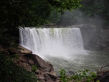
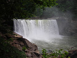
. Cumberland Falls
, located in Cumberland Falls State Resort Park
, is the site of the largest waterfall in the Commonwealth of Kentucky. Both Daniel Boone Forest and Cumberland Falls State Park are operated by the Kentucky State Parks system, also located in the county. Two regionally significant waterways meander through the county, namely the Laurel and Cumberland
river.
, agriculture in the county has historically been quite stunted, although tobacco and corn are grown in some areas.
of 2000, there were 35,865 people, 13,780 households, and 9,894 families residing in the county. The population density
was 82 /sqmi. There were 15,288 housing units at an average density of 35 /sqmi. The racial makeup of the county was 98.37% White
, 0.34% Black or African American
, 0.23% Native American
, 0.20% Asian
, 0.01% Pacific Islander
, 0.09% from other races, and 0.76% from two or more races
. 0.69% of the population were Hispanics or Latinos
of any race.
There were 13,780 households out of which 33.70% had children under the age of 18 living with them, 54.90% were married couples
living together, 13.00% had a female householder with no husband present, and 28.20% were non-families. 25.20% of all households were made up of individuals and 10.20% had someone living alone who was 65 years of age or older. The average household size was 2.52 and the average family size was 3.01.
The age distribution was 25.80% under 18, 10.80% from 18 to 24, 27.30% from 25 to 44, 23.20% from 45 to 64, and 12.90% who were 65 or older. The median age was 35 years. For every 100 females there were 93.30 males. For every 100 females age 18 and over, there were 89.60 males.
The median income for a household in the county was $22,075, and the median income for a family was $27,871. Males had a median income of $26,518 versus $17,001 for females. The per capita income
for the county was $12,777. About 21.60% of families and 26.40% of the population were below the poverty line, including 34.10% of those under age 18 and 19.00% of those age 65 or over.
(formerly known as Cumberland College), located in Williamsburg, is the largest private university in Kentucky, and the only university with its main campus in Whitley County. The school's sports teams play on the NAIA
level and provide college level sporting events for the local community. In addition, Eastern Kentucky University
maintains a branch campus in the Whitley County portion of Corbin.
County (United States)
In the United States, a county is a geographic subdivision of a state , usually assigned some governmental authority. The term "county" is used in 48 of the 50 states; Louisiana is divided into parishes and Alaska into boroughs. Parishes and boroughs are called "county-equivalents" by the U.S...
located in the state
U.S. state
A U.S. state is any one of the 50 federated states of the United States of America that share sovereignty with the federal government. Because of this shared sovereignty, an American is a citizen both of the federal entity and of his or her state of domicile. Four states use the official title of...
of Kentucky
Kentucky
The Commonwealth of Kentucky is a state located in the East Central United States of America. As classified by the United States Census Bureau, Kentucky is a Southern state, more specifically in the East South Central region. Kentucky is one of four U.S. states constituted as a commonwealth...
. 2005 census projections list its population at 38,029 http://quickfacts.census.gov/qfd/states/21/21235.html. The county seat
County seat
A county seat is an administrative center, or seat of government, for a county or civil parish. The term is primarily used in the United States....
is at Williamsburg
Williamsburg, Kentucky
As of the census of 2000, there were 5,143 people, 1,928 households, and 1,127 families residing in the city. The population density was 1,102.5 people per square mile . There were 2,118 housing units at an average density of 454.0 per square mile...
, though the largest city is Corbin
Corbin, Kentucky
- Economy :Originally formed by L&N Railroad, rail transport was the backbone of the local economy in the first half of the twentieth century. While the railroad continues to play an important role, the decline of the rail industry in the latter half of the twentieth century, as well as the loss...
, and the county's District Court (a trial court of limited jurisdiction) sits in both cities. Whitley County is a limited dry county
Dry county
A dry county is a county in the United States whose government forbids the sale of alcoholic beverages. Some prohibit off-premises sale, some prohibit on-premises sale, and some prohibit both. Hundreds of dry counties exist across the United States, almost all of them in the South...
, meaning that sale of alcohol in the county is prohibited except in certain areas as voted on by the residents of the area. In the case of Whitley County, by the drink alcohol sales is permitted only in restaurants in the city of Corbin seating at least 100 diners and derive at least 70% of their total sales from food.
The Corbin, KY Micropolitan Statistical Area
Corbin, KY Micropolitan Statistical Area
The Corbin Micropolitan Statistical Area, as defined by the United States Census Bureau, is an area consisting of Whitley County, Kentucky, anchored by the Whitley County portion of the city of Corbin...
includes all of Whitley County, but does not include all of the city of Corbin.
History
Whitley County was created on January 17, 1818 from adjacent Knox County, KentuckyKnox County, Kentucky
Knox County is a county located in the U.S. state of Kentucky. As of 2000, the population was 31,795. Its county seat is Barbourville. The county is named for General Henry Knox...
http://www.kycourts.net/Counties/Whitley_text.asp. In the years prior to its establishment as an independent county, many skirmishes were fought between native Indians and hunters and trappers in the area. The namesake of the county, Colonel William Whitley
William Whitley
William Whitley , was an American pioneer born in what was then Augusta County, Virginia, the son of Solomon and Elizabeth Whitley...
, is famous locally for fighting many of these battles within the area, eventually driving them out of southeastern Kentucky and safeguarding the Wilderness Road
Wilderness Road
The Wilderness Road was the principal route used by settlers for more than fifty years to reach Kentucky from the East. In 1775, Daniel Boone blazed a trail for the Transylvania Company from Fort Chiswell in Virginia through the Cumberland Gap into central Kentucky. It was later lengthened,...
, as well as for his service in the War of 1812
War of 1812
The War of 1812 was a military conflict fought between the forces of the United States of America and those of the British Empire. The Americans declared war in 1812 for several reasons, including trade restrictions because of Britain's ongoing war with France, impressment of American merchant...
, where he died at the Battle of the Thames
Battle of the Thames
The Battle of the Thames, also known as the Battle of Moraviantown, was a decisive American victory in the War of 1812. It took place on October 5, 1813, near present-day Chatham, Ontario in Upper Canada...
. The county seat was situated in Williamsburg (also named for Colonel Whitley, in 1882) from the beginning, with the first court held at the home of the town's first resident, Samuel Cox http://www.uky.edu/KentuckyAtlas/21235d.html.
Its rugged terrain, densely forested woodlands, and a history of conflict with local Indian tribes
Indian tribes
The India's tribal belts refer to contiguous areas of indigenous settlement of tribal people of India.-Northwest India:The Tribal Belt of Northwest India includes the states of Rajasthan, Gujarat, Maharashtra, and Karnataka. The tribal people of this region have origins which precede the Vedic...
all combined to make for a very slow rate of growth in Whitley County. The development of the coal mining
Coal mining
The goal of coal mining is to obtain coal from the ground. Coal is valued for its energy content, and since the 1880s has been widely used to generate electricity. Steel and cement industries use coal as a fuel for extraction of iron from iron ore and for cement production. In the United States,...
industry in the area towards the late 1800s spurred on population growth as poor families from neighboring states rushed in to the county and led to the formation of Corbin, still the largest city in Whitley County.
North Corbin
North Corbin, Kentucky
North Corbin is a census-designated place in Knox and Laurel counties in the U.S. state of Kentucky. The population was 1,662 at the 2000 census....
, just north of Whitley County is home to Sanders Cafe
Harland Sanders Café and Museum
The Harland Sanders Café is a historic restaurant located in North Corbin, Kentucky. Colonel Harland Sanders, the founder of Kentucky Fried Chicken, operated the restaurant from 1940-1956. Sanders also developed the famous KFC secret recipe at the café during the 1940s...
, which is the birthplace of Kentucky Fried Chicken. It was founded there by Harland David Sanders, better known as Colonel Sanders
Colonel Sanders
Harland David "Colonel" Sanders was an American fast food businessman who founded the Kentucky Fried Chicken restaurant chain, now re-branded as KFC...
, in 1930.
Law and Government
The current elected officials of Whitley County are:http://www.whitleycountyfiscalcourt.com/officials.asp:- County Judge/Executive: Pat White, Jr.
- County Magistrate: Roger Wells
- County Magistrate: David Myers
- County Magistrate: Jamie Fuson
- County Magistrate: Mike Baird
- County Attorney: Paul Winchester
- County Coroner: Andy Croley
- County Treasurer: Jeffrey Gray
- Sheriff: Colan Harrell
- County Surveyor: Robert Moses
- Property Valuation Administrator: Ronnie Moses
- County Clerk: Kay Schwartz
- Circuit Court Clerk: Gary Barton
Geography
Whitley County is located within the Cumberland Plateau
Cumberland Plateau
The Cumberland Plateau is the southern part of the Appalachian Plateau. It includes much of eastern Kentucky and western West Virginia, part of Tennessee, and a small portion of northern Alabama and northwest Georgia . The terms "Allegheny Plateau" and the "Cumberland Plateau" both refer to the...
of southeastern Kentucky, which is greatly overlapped by the broad Eastern Coal Field region of the state. Because of its location in the midst of Cumberland Mountains
Cumberland Mountains
The Cumberland Mountains are a mountain range in the southeastern section of the Appalachian Mountains. They are located in southern West Virginia, western Virginia, eastern edges of Kentucky, and eastern middle Tennessee, including the Crab Orchard Mountains...
, elevations in the county range from 723 feet (220.4 m) to 2220 feet (676.7 m) above sea level http://www.uky.edu/KentuckyAtlas/21235.html. 38000 acres (153.8 km²) of western Whitley County are preserved within the Daniel Boone National Forest
Daniel Boone National Forest
Daniel Boone National Forest is the only national forest completely within the boundary of Kentucky. Established in 1937, it was originally named the Cumberland National Forest, after the core region called the Cumberland Purchase Unit...
. Cumberland Falls
Cumberland Falls
Cumberland Falls, sometimes called the Little Niagara, the Niagara of the South, or the Great Falls, is a large waterfall on the Cumberland River in southeastern Kentucky...
, located in Cumberland Falls State Resort Park
Cumberland Falls State Resort Park
Cumberland Falls State Resort Park is a park located just southwest of Corbin, Kentucky and is contained entirely within the Daniel Boone National Forest. The park encompasses and is named for its major feature, tall Cumberland Falls...
, is the site of the largest waterfall in the Commonwealth of Kentucky. Both Daniel Boone Forest and Cumberland Falls State Park are operated by the Kentucky State Parks system, also located in the county. Two regionally significant waterways meander through the county, namely the Laurel and Cumberland
Cumberland River
The Cumberland River is a waterway in the Southern United States. It is long. It starts in Harlan County in far southeastern Kentucky between Pine and Cumberland mountains, flows through southern Kentucky, crosses into northern Tennessee, and then curves back up into western Kentucky before...
river.
Geographic features
- Cumberland FallsCumberland FallsCumberland Falls, sometimes called the Little Niagara, the Niagara of the South, or the Great Falls, is a large waterfall on the Cumberland River in southeastern Kentucky...
- Cumberland PlateauCumberland PlateauThe Cumberland Plateau is the southern part of the Appalachian Plateau. It includes much of eastern Kentucky and western West Virginia, part of Tennessee, and a small portion of northern Alabama and northwest Georgia . The terms "Allegheny Plateau" and the "Cumberland Plateau" both refer to the...
- Cumberland RiverCumberland RiverThe Cumberland River is a waterway in the Southern United States. It is long. It starts in Harlan County in far southeastern Kentucky between Pine and Cumberland mountains, flows through southern Kentucky, crosses into northern Tennessee, and then curves back up into western Kentucky before...
- Jellico Mountain
- Laurel River
- Laurel River LakeLaurel River LakeLaurel River Lake, located west of Corbin, Kentucky, in the USA, is an reservoir built in 1977 by the U.S. Army Corps of Engineers on the Laurel River, a tributary of the Cumberland River, in the Daniel Boone National Forest. The lake covers parts of Laurel and Whitley counties.The 282 foot high...
Major highways
- Interstate 75Interstate 75Interstate 75 is a major north–south Interstate Highway in the Great Lakes and Southeastern regions of the United States. It travels from State Road 826 and State Road 924 in Hialeah, Florida to Sault Ste. Marie, Michigan, at the Ontario, Canada, border...
- U.S. Route 25W
- State highways
- Kentucky Route 11
- Kentucky Route 26Kentucky Route 26Kentucky Route 26 ' serves as a shorter alternate route for traffic using US 25W between Williamsburg and Corbin in Whitley County. The southern terminus of KY 26 is at US 25W north of Williamsburg, and its northern terminus is also at US 25W, this time in Corbin...
- Kentucky Route 90Kentucky Route 90Kentucky Route 90 originates at a junction with KY 70 near I-65 in Cave City in Barren County. The route continues through Metcalfe County, Cumberland County, Clinton County, Wayne County, Pulaski...
- Kentucky Route 92Kentucky Route 92Kentucky Route 92 is a 84.9 mile long state highway in southern Kentucky. The route runs from Monticello in Wayne County to Pineville in Bell County. Another segment of KY 92 runs from a point at Joppa to the end of the road at Lake Cumberland near Jamestown...
- Kentucky Route 312
- Kentucky Route 904
Adjacent counties
- Laurel CountyLaurel County, KentuckyLaurel County is a county in the U.S. state of Kentucky. The population was 58,849 in the 2010 Census. Its county seat is London.The London Micropolitan Statistical Area includes all of Laurel County....
- north - Knox CountyKnox County, KentuckyKnox County is a county located in the U.S. state of Kentucky. As of 2000, the population was 31,795. Its county seat is Barbourville. The county is named for General Henry Knox...
- northeast - Bell CountyBell County, KentuckyBell County is a county located in the U.S. state of Kentucky. It was formed August 1, 1867, from parts of Knox and Harlan Counties and augmented from Knox County in 1872. As of 2010 the population was 69,060. Its county seat is Pineville...
- east - Claiborne County, Tennessee - southeast
- Campbell County, TennesseeCampbell County, TennesseeCampbell County is a U.S. county located in the U.S. state of Tennessee. As of 2010, the population was 40,716. Its county seat is Jacksboro. The Census Bureau has identified the county as a Micropolitan Statistical Area, designated the LaFollette Micropolitan Statistical Area for the largest...
- south - McCreary CountyMcCreary County, KentuckyMcCreary County is a county located in the U.S. state of Kentucky. As of 2000, the population was 17,080. Its county seat is Whitley City. The county is named for James B. McCreary, a Confederate war hero and Governor of Kentucky from 1875 to 1879. It is the only Kentucky county to not have a...
- west
Economy
Whitley County's economy has always relied heavily on its natural resources, particularly coal and timber, as the area's heavily forested, mountainous terrain contains abundant sources of such material. Other resources worked in the area include iron, oil, and very small amounts of silver. Due to the rough territory created by the Cumberland MountainsCumberland Mountains
The Cumberland Mountains are a mountain range in the southeastern section of the Appalachian Mountains. They are located in southern West Virginia, western Virginia, eastern edges of Kentucky, and eastern middle Tennessee, including the Crab Orchard Mountains...
, agriculture in the county has historically been quite stunted, although tobacco and corn are grown in some areas.
Demographics
As of the censusCensus
A census is the procedure of systematically acquiring and recording information about the members of a given population. It is a regularly occurring and official count of a particular population. The term is used mostly in connection with national population and housing censuses; other common...
of 2000, there were 35,865 people, 13,780 households, and 9,894 families residing in the county. The population density
Population density
Population density is a measurement of population per unit area or unit volume. It is frequently applied to living organisms, and particularly to humans...
was 82 /sqmi. There were 15,288 housing units at an average density of 35 /sqmi. The racial makeup of the county was 98.37% White
White American
White Americans are people of the United States who are considered or consider themselves White. The United States Census Bureau defines White people as those "having origins in any of the original peoples of Europe, the Middle East, or North Africa...
, 0.34% Black or African American
African American
African Americans are citizens or residents of the United States who have at least partial ancestry from any of the native populations of Sub-Saharan Africa and are the direct descendants of enslaved Africans within the boundaries of the present United States...
, 0.23% Native American
Native Americans in the United States
Native Americans in the United States are the indigenous peoples in North America within the boundaries of the present-day continental United States, parts of Alaska, and the island state of Hawaii. They are composed of numerous, distinct tribes, states, and ethnic groups, many of which survive as...
, 0.20% Asian
Asian American
Asian Americans are Americans of Asian descent. The U.S. Census Bureau definition of Asians as "Asian” refers to a person having origins in any of the original peoples of the Far East, Southeast Asia, or the Indian subcontinent, including, for example, Cambodia, China, India, Indonesia, Japan,...
, 0.01% Pacific Islander
Pacific Islander American
Pacific Islander Americans, also known as Oceanian Americans, are residents of the United States with original ancestry from Oceania. They represent the smallest racial group counted in the United States census of 2000. They numbered 874,000 people or 0.3 percent of the United States population...
, 0.09% from other races, and 0.76% from two or more races
Multiracial American
Multiracial Americans, US residents who identify themselves as of "two or more races", were numbered at around 9 million, or 2.9% of the population, in the census of 2010. However there is considerable evidence that the real number is far higher. Prior to the mid-20th century many people hid their...
. 0.69% of the population were Hispanics or Latinos
Hispanic and Latino Americans
Hispanic or Latino Americans are Americans with origins in the Hispanic countries of Latin America or in Spain, and in general all persons in the United States who self-identify as Hispanic or Latino.1990 Census of Population and Housing: A self-designated classification for people whose origins...
of any race.
There were 13,780 households out of which 33.70% had children under the age of 18 living with them, 54.90% were married couples
Marriage
Marriage is a social union or legal contract between people that creates kinship. It is an institution in which interpersonal relationships, usually intimate and sexual, are acknowledged in a variety of ways, depending on the culture or subculture in which it is found...
living together, 13.00% had a female householder with no husband present, and 28.20% were non-families. 25.20% of all households were made up of individuals and 10.20% had someone living alone who was 65 years of age or older. The average household size was 2.52 and the average family size was 3.01.
The age distribution was 25.80% under 18, 10.80% from 18 to 24, 27.30% from 25 to 44, 23.20% from 45 to 64, and 12.90% who were 65 or older. The median age was 35 years. For every 100 females there were 93.30 males. For every 100 females age 18 and over, there were 89.60 males.
The median income for a household in the county was $22,075, and the median income for a family was $27,871. Males had a median income of $26,518 versus $17,001 for females. The per capita income
Per capita income
Per capita income or income per person is a measure of mean income within an economic aggregate, such as a country or city. It is calculated by taking a measure of all sources of income in the aggregate and dividing it by the total population...
for the county was $12,777. About 21.60% of families and 26.40% of the population were below the poverty line, including 34.10% of those under age 18 and 19.00% of those age 65 or over.
Incorporated
- CorbinCorbin, Kentucky- Economy :Originally formed by L&N Railroad, rail transport was the backbone of the local economy in the first half of the twentieth century. While the railroad continues to play an important role, the decline of the rail industry in the latter half of the twentieth century, as well as the loss...
- (Partly in Knox CountyKnox County, KentuckyKnox County is a county located in the U.S. state of Kentucky. As of 2000, the population was 31,795. Its county seat is Barbourville. The county is named for General Henry Knox...
) - WilliamsburgWilliamsburg, KentuckyAs of the census of 2000, there were 5,143 people, 1,928 households, and 1,127 families residing in the city. The population density was 1,102.5 people per square mile . There were 2,118 housing units at an average density of 454.0 per square mile...
Other communities
- Canada Town
- CarpenterCarpenter, KentuckyCarpenter, is a community or populated place located in Whitley County, Kentucky with an elevation of 1,017 feet. Carpenter appears on the Frakes U.S. Geological Survey Map....
- Gatliff
- Goldbug
- Julip
- PackardPackard, KentuckyPackard is a ghost town in Whitley County, Kentucky, United States. Packard was located southeast of Williamsburg. The community was a coal town which served the Packard Coal Company; the community and the company were named after Whitley County school teacher Amelia Packard...
- Piney Grove
- Pleasant View
- Rockholds
- Saxton
- Siler
- WoffordWofford, KentuckyWofford is an unincorporated community in Whitley County, Kentucky, United States. It is located approximately three miles north-northeast of Williamsburg on Route 26.- History :Wofford was initially named Mahan for a local family in residence...
- WoodbineWoodbine, KentuckyWoodbine is an unincorporated community in the Cumberland Mountains region in Whitley County, Kentucky, United States....
- Yaden
K-12
Three public school districts serve the county:- Whitley County School District
- The largest of the three districts, it serves the county outside of the cities of Corbin and Williamsburg.
- Williamsburg Independent School District
- Serves the city of Williamsburg with a single K-12 school.
- Corbin Independent School District
- Serves the entire city of Corbin, making it one of the few districts in Kentucky whose boundaries cross county lines.
Colleges and universities
The University of the CumberlandsUniversity of the Cumberlands
University of the Cumberlands is a private, liberal arts college located in Williamsburg, Kentucky, with an enrollment of approximately 3,200 students...
(formerly known as Cumberland College), located in Williamsburg, is the largest private university in Kentucky, and the only university with its main campus in Whitley County. The school's sports teams play on the NAIA
National Association of Intercollegiate Athletics
The National Association of Intercollegiate Athletics is an athletic association that organizes college and university-level athletic programs. Membership in the NAIA consists of smaller colleges and universities across the United States. The NAIA allows colleges and universities outside the USA...
level and provide college level sporting events for the local community. In addition, Eastern Kentucky University
Eastern Kentucky University
Eastern Kentucky University, commonly referred to as Eastern or by the acronym EKU by local residents, is an undergraduate and graduate teaching and research institution located in Richmond, Kentucky, U.S.A.. EKU is accredited by the Southern Association of Colleges and Schools...
maintains a branch campus in the Whitley County portion of Corbin.
See also
- Dry counties
- Corbin-London, KY Combined Statistical AreaCorbin-London, KY Combined Statistical AreaThe Corbin-London Combined Statistical Area is made up of two counties in the Eastern Mountain Coal Fields region of Kentucky. The CSA consists of the Corbin Micropolitan Statistical Area and the London Micropolitan Statistical Area...
- National Register of Historic Places listings in Whitley County, KentuckyNational Register of Historic Places listings in Whitley County, KentuckyThis is a list of the National Register of Historic Places listings in Whitley County, Kentucky. It is intended to be a complete list of the properties and districts on the National Register of Historic Places in Whitley County, Kentucky, United States...