
Kapalua, Hawaii
Encyclopedia
Census-designated place
A census-designated place is a concentration of population identified by the United States Census Bureau for statistical purposes. CDPs are delineated for each decennial census as the statistical counterparts of incorporated places such as cities, towns and villages...
(CDP) in Maui County
Maui County, Hawaii
-National protected areas:* Haleakala National Park* Kakahaia National Wildlife Refuge* Kealia Pond National Wildlife Refuge- Demographics :As of the 2000 Census, there were 128,094 people, 43,507 households, and 29,889 families residing in the county. The population density was 110 people per...
, Hawaii
Hawaii
Hawaii is the newest of the 50 U.S. states , and is the only U.S. state made up entirely of islands. It is the northernmost island group in Polynesia, occupying most of an archipelago in the central Pacific Ocean, southwest of the continental United States, southeast of Japan, and northeast of...
, United States
United States
The United States of America is a federal constitutional republic comprising fifty states and a federal district...
. A resort development by the Maui Land & Pineapple Company
Maui Land & Pineapple Company
Maui Land & Pineapple Company, Inc. is a land holding and operating company founded in 1909 and based in Maui, Hawaii, United States. It owns approximately on the island of Maui. It develops, sells, and manages residential, resort, commercial and industrial real estate; and operates retail, golf...
extends inland from Kapalua Bay and Honolua Bay. The population was 467 at the 2000 census.
Geography
Kapalua is located along the northwest coast of Maui at 20°59′48"N 156°39′11"W along Route 30, known as the Honoapiilani Highway. The Hawaiian name for this area was Honokahua.According to the United States Census Bureau
United States Census Bureau
The United States Census Bureau is the government agency that is responsible for the United States Census. It also gathers other national demographic and economic data...
, the CDP has a total area of 2.3 square miles (6 km²), of which 1.7 square miles (4.4 km²) is land and 0.6 square miles (1.6 km²) of it (26.92%) is water.
Kapalua has a view of the islands of Molokai
Molokai
Molokai or Molokai is an island in the Hawaiian archipelago. It is 38 by 10 miles in size with a land area of , making it the fifth largest of the main Hawaiian Islands and the 27th largest island in the United States. It lies east of Oahu across the 25-mile wide Kaiwi Channel and north of...
and Lānai
Lanai
Lānai or Lanai is the sixth-largest of the Hawaiian Islands. It is also known as the Pineapple Island because of its past as an island-wide pineapple plantation. The only town is Lānai City, a small settlement....
.
Recreation & leisure
Kapalua ResortKapalua Resort
Kapalua Resort is a golf and beach resort in Kapalua, Hawaii on the northwest shore of the island of Maui near Lahaina, Hawaii.-Description:Surrounded by from the verdant mountain ridges and summit of Puu Kukui to lava rock bays, Kapalua Resort is set amidst two nature preserves and former...
offers accommodations, a variety of restaurants, a shop, and several golf
Golf
Golf is a precision club and ball sport, in which competing players use many types of clubs to hit balls into a series of holes on a golf course using the fewest number of strokes....
courses.
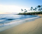
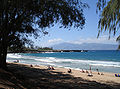
The area has several beaches: Kapalua Bay, is the resort namesake at 20°59′58"N 156°40′0"W. The name kapa lua means "two borders" in the Hawaiian language
Hawaiian language
The Hawaiian language is a Polynesian language that takes its name from Hawaii, the largest island in the tropical North Pacific archipelago where it developed. Hawaiian, along with English, is an official language of the state of Hawaii...
.
Oneloa Bay at 21°0′17"N 156°39′31"W and Honokahua Bay are also backed by the resort. Mokuleia Bay and Honolua Bay are to the north in Honolua
Honolua, Hawaii
Honolua Bay, Mokuleia Bay and Lipoa Point are part of an area known as the ahupua'a of Honolua, located just North of Kapalua, West Maui in Maui County, Hawaii, United States. The area is a mix of agricultural and conservation land tended by the Maui Land & Pineapple Company in Lahaina, Hawaii,...
, and Nāpili
Napili, Hawaii
Napili is an unincorporated area located north of Lāhainā, West Maui, Hawaii, United States. Napili Beach is a small beach surrounded by condominiums, and the local neighborhoods of Hui Road and Napilihau are home to hundreds of the people who work in West Maui's tourist industry.-See...
to the south. Kapalua Bay was named "Best Beach in the World" by the readers of Conde Nast Traveler
Condé Nast Traveler
Condé Nast Traveler is a US magazine published by Condé Nast. It has its origins in a mailing sent out by the Diners Club club beginning in 1953, listing locations that would take the card. It began taking advertising in 1955. In order to attract more advertisers, it became a full-fledged magazine,...
Magazine, "America's Best Beach" on the first annual list of Stephen Leatherman
Stephen Leatherman
Stephen P. Leatherman is the director of the Laboratory for Coastal Research at Florida International University.In addition to his educational duties, Dr. Leatherman is known for his annual rankings of American beaches, thus earning him the nickname "Dr. Beach".-Education:Leatherman earned his...
's Top 10 Beaches in America, and the "Best Beach in America" by The Travel Channel, among other honors.
During the plantation era, the Kapalua beach was known as Fleming Beach but was renamed after the resort. A public access site on Honokahua Bay about half a mile to the north was named D.T. Fleming Park in 1975 to keep the tribute to David Thomas Fleming (1881–1955), Honolua Plantation manager of the area before the resort was built.
Transportation
The small Kapalua AirportKapalua Airport
Kapalua Airport , also known as Kapalua West Maui Airport, is a regional airport on the west side of the island of Maui. It is located northwest of Lahaina, in Maui County, Hawaii, United States....
was built to the south in Honokōwai
Napili-Honokowai, Hawaii
Nāpili-Honokōwai is a census-designated place in Maui County, Hawaii, United States. The population was 6,788 at the 2000 census.-Geography:Nāpili-Honokōwai is located at ....
in 1987, replacing the even smaller Kaanapali Airport
Kaanapali Airport
Kaanapali Airport was a small regional airport located on the northwest end of Maui, near the city of Lahaina and north of Kaanapali Beach in Honokōwai...
.
Demographics
As of the censusCensus
A census is the procedure of systematically acquiring and recording information about the members of a given population. It is a regularly occurring and official count of a particular population. The term is used mostly in connection with national population and housing censuses; other common...
of 2000, there were 467 people, 186 households, and 132 families residing in the CDP. The population density
Population density
Population density is a measurement of population per unit area or unit volume. It is frequently applied to living organisms, and particularly to humans...
was 272.9 people per square mile (105.4/km²). There were 831 housing units at an average density of 485.6 per square mile (187.6/km²). The racial makeup of the CDP was 59.31% White, 0.43% African American, 11.35% Asian, 13.28% Pacific Islander, 0.21% from other races
Race (United States Census)
Race and ethnicity in the United States Census, as defined by the Federal Office of Management and Budget and the United States Census Bureau, are self-identification data items in which residents choose the race or races with which they most closely identify, and indicate whether or not they are...
, and 15.42% from two or more races. Hispanic or Latino of any race were 3.43% of the population.
There were 186 households out of which 25.3% had children under the age of 18 living with them, 62.9% were married couples
Marriage
Marriage is a social union or legal contract between people that creates kinship. It is an institution in which interpersonal relationships, usually intimate and sexual, are acknowledged in a variety of ways, depending on the culture or subculture in which it is found...
living together, 4.3% had a female householder with no husband present, and 28.5% were non-families. 12.9% of all households were made up of individuals and 4.3% had someone living alone who was 65 years of age or older. The average household size was 2.51 and the average family size was 2.74.
In the CDP the population was spread out with 17.6% under the age of 18, 6.4% from 18 to 24, 32.1% from 25 to 44, 27.2% from 45 to 64, and 16.7% who were 65 years of age or older. The median age was 42 years. For every 100 females there were 92.2 males. For every 100 females age 18 and over, there were 108.1 males.
The median income for a household in the CDP was $57,292, and the median income for a family was $61,875. Males had a median income of $35,417 versus $32,321 for females. The per capita income
Per capita income
Per capita income or income per person is a measure of mean income within an economic aggregate, such as a country or city. It is calculated by taking a measure of all sources of income in the aggregate and dividing it by the total population...
for the CDP was $75,992. About 5.1% of families and 7.2% of the population were below the poverty line, including 5.6% of those under age 18 and none of those age 65 or over.