
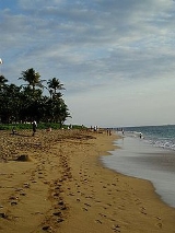
Kaanapali, Hawaii
Encyclopedia
Kāanapali is a census-designated place
(CDP) in Maui County
, Hawaii
, United States
. The population was 1,375 at the 2000 census. The master-planned town is located in the Old Hawaii ahupuaa of Hanakao`o, as in the same name of the southern end of Kaanapali Beach's Hanakao`o Canoe Beach.
According to the United States Census Bureau
, the CDP has a total area of 5.7 square miles (14.8 km²), of which, 4.9 square miles (12.7 km²) of it is land and 0.9 square miles (2.3 km²) of it (15.03%) is water.
of 2000, there were 1,375 people, 537 households, and 380 families residing in the CDP. The population density
was 282.8 people per square mile (109.2/km²). There were 1,775 housing units at an average density of 365.1 per square mile (141.0/km²). The racial makeup of the CDP was 79.07% White, 0.95% African American, 0.15% Native American, 17.42% Asian, 3.04% Pacific Islander, 1.96% from other races
, and 7.42% from two or more races. Hispanic or Latino of any race were 0.55% of the population.
There were 537 households out of which 20.5% had children under the age of 18 living with them, 59.4% were married couples
living together, 7.3% had a female householder with no husband present, and 29.1% were non-families. 16.6% of all households were made up of individuals and 6.0% had someone living alone who was 65 years of age or older. The average household size was 2.56 and the average family size was 2.73.
In the CDP the population was spread out with 16.3% under the age of 18, 3.4% from 18 to 24, 30.6% from 25 to 44, 33.8% from 45 to 64, and 15.9% who were 65 years of age or older. The median age was 45 years. For every 100 females there were 111.5 males. For every 100 females age 18 and over, there were 113.5 males.
The median income for a household in the CDP was $79,288, and the median income for a family was $86,647. Males had a median income of $48,393 versus $41,625 for females. The per capita income
for the CDP was $48,506. About 1.6% of families and 2.7% of the population were below the poverty line, including none of those under the age of eighteen or sixty-five or over.
, a couple miles north of the old whaling town of Lahaina. Since that time, many more hotels and condos have been built both on Kāanapali Beach and for several miles up and down the coast, and Lahaina has turned into a tourist shopping area.
Major resort hotels now on Kāanapali Beach (in order from the south end closest to Lahaina to the north end) are the Hyatt Regency Maui (opened in 1980), Maui Marriott (opened 1982, now turned into timeshares), Westin (originally opened as the Maui Surf in 1971, then rebuilt as the Westin 1987), Kaanapali Beach Hotel (1964), Sheraton (1963 but completely rebuilt in 1996), Royal Lahaina (1962), and Maui Kaanapali Villas (originally a Hilton when it opened in 1963).
Beside the hotel resorts there are also condominium complexes on Kaanapali Beach. Toward Lahaina between the Marriott and the Westin is the Alii. Moving further north on Kaanapali beach between Whalers Village (shopping center) and The Kaanapli Beach Hotel, is The Whaler. On the north side of Kaanapali Beach (north of black rock) there are two new complexes. The Westin Ka'anapali Ocean Resort Villas is a timeshare complex, with two buildings completed and one under construction as of August 2010. The Honua Kai condominium complex is just south of the Aston Mahana condominiums (formerly ResortQuest Hawaii).
is a small regional airport that services West Maui, including Kāanapali, Lahaina and Kapalua. The airport has been in service since 1987.
From 1965 to 1986, Kaanapali had its own airport
located in the Kaanapali North Beach area, recently developed as the three Starwood Westin Kaanapali Ocean Club timeshare complexes and Honu Kai condo complex.
Census-designated place
A census-designated place is a concentration of population identified by the United States Census Bureau for statistical purposes. CDPs are delineated for each decennial census as the statistical counterparts of incorporated places such as cities, towns and villages...
(CDP) in Maui County
Maui County, Hawaii
-National protected areas:* Haleakala National Park* Kakahaia National Wildlife Refuge* Kealia Pond National Wildlife Refuge- Demographics :As of the 2000 Census, there were 128,094 people, 43,507 households, and 29,889 families residing in the county. The population density was 110 people per...
, Hawaii
Hawaii
Hawaii is the newest of the 50 U.S. states , and is the only U.S. state made up entirely of islands. It is the northernmost island group in Polynesia, occupying most of an archipelago in the central Pacific Ocean, southwest of the continental United States, southeast of Japan, and northeast of...
, United States
United States
The United States of America is a federal constitutional republic comprising fifty states and a federal district...
. The population was 1,375 at the 2000 census. The master-planned town is located in the Old Hawaii ahupuaa of Hanakao`o, as in the same name of the southern end of Kaanapali Beach's Hanakao`o Canoe Beach.
Geography
Kāanapali is located at 20°56′5"N 156°40′46"W (20.934820, -156.679329).According to the United States Census Bureau
United States Census Bureau
The United States Census Bureau is the government agency that is responsible for the United States Census. It also gathers other national demographic and economic data...
, the CDP has a total area of 5.7 square miles (14.8 km²), of which, 4.9 square miles (12.7 km²) of it is land and 0.9 square miles (2.3 km²) of it (15.03%) is water.
Demographics
As of the censusCensus
A census is the procedure of systematically acquiring and recording information about the members of a given population. It is a regularly occurring and official count of a particular population. The term is used mostly in connection with national population and housing censuses; other common...
of 2000, there were 1,375 people, 537 households, and 380 families residing in the CDP. The population density
Population density
Population density is a measurement of population per unit area or unit volume. It is frequently applied to living organisms, and particularly to humans...
was 282.8 people per square mile (109.2/km²). There were 1,775 housing units at an average density of 365.1 per square mile (141.0/km²). The racial makeup of the CDP was 79.07% White, 0.95% African American, 0.15% Native American, 17.42% Asian, 3.04% Pacific Islander, 1.96% from other races
Race (United States Census)
Race and ethnicity in the United States Census, as defined by the Federal Office of Management and Budget and the United States Census Bureau, are self-identification data items in which residents choose the race or races with which they most closely identify, and indicate whether or not they are...
, and 7.42% from two or more races. Hispanic or Latino of any race were 0.55% of the population.
There were 537 households out of which 20.5% had children under the age of 18 living with them, 59.4% were married couples
Marriage
Marriage is a social union or legal contract between people that creates kinship. It is an institution in which interpersonal relationships, usually intimate and sexual, are acknowledged in a variety of ways, depending on the culture or subculture in which it is found...
living together, 7.3% had a female householder with no husband present, and 29.1% were non-families. 16.6% of all households were made up of individuals and 6.0% had someone living alone who was 65 years of age or older. The average household size was 2.56 and the average family size was 2.73.
In the CDP the population was spread out with 16.3% under the age of 18, 3.4% from 18 to 24, 30.6% from 25 to 44, 33.8% from 45 to 64, and 15.9% who were 65 years of age or older. The median age was 45 years. For every 100 females there were 111.5 males. For every 100 females age 18 and over, there were 113.5 males.
The median income for a household in the CDP was $79,288, and the median income for a family was $86,647. Males had a median income of $48,393 versus $41,625 for females. The per capita income
Per capita income
Per capita income or income per person is a measure of mean income within an economic aggregate, such as a country or city. It is calculated by taking a measure of all sources of income in the aggregate and dividing it by the total population...
for the CDP was $48,506. About 1.6% of families and 2.7% of the population were below the poverty line, including none of those under the age of eighteen or sixty-five or over.
Resorts
Amfac, Inc. started to develop Kaanapali Beach Resort in the 1960s, on mile-long Kāanapali Beach, on the western shore of MauiMaui
The island of Maui is the second-largest of the Hawaiian Islands at and is the 17th largest island in the United States. Maui is part of the state of Hawaii and is the largest of Maui County's four islands, bigger than Lānai, Kahoolawe, and Molokai. In 2010, Maui had a population of 144,444,...
, a couple miles north of the old whaling town of Lahaina. Since that time, many more hotels and condos have been built both on Kāanapali Beach and for several miles up and down the coast, and Lahaina has turned into a tourist shopping area.
Major resort hotels now on Kāanapali Beach (in order from the south end closest to Lahaina to the north end) are the Hyatt Regency Maui (opened in 1980), Maui Marriott (opened 1982, now turned into timeshares), Westin (originally opened as the Maui Surf in 1971, then rebuilt as the Westin 1987), Kaanapali Beach Hotel (1964), Sheraton (1963 but completely rebuilt in 1996), Royal Lahaina (1962), and Maui Kaanapali Villas (originally a Hilton when it opened in 1963).
Beside the hotel resorts there are also condominium complexes on Kaanapali Beach. Toward Lahaina between the Marriott and the Westin is the Alii. Moving further north on Kaanapali beach between Whalers Village (shopping center) and The Kaanapli Beach Hotel, is The Whaler. On the north side of Kaanapali Beach (north of black rock) there are two new complexes. The Westin Ka'anapali Ocean Resort Villas is a timeshare complex, with two buildings completed and one under construction as of August 2010. The Honua Kai condominium complex is just south of the Aston Mahana condominiums (formerly ResortQuest Hawaii).
Airports
The Kapalua-West Maui AirportKapalua Airport
Kapalua Airport , also known as Kapalua West Maui Airport, is a regional airport on the west side of the island of Maui. It is located northwest of Lahaina, in Maui County, Hawaii, United States....
is a small regional airport that services West Maui, including Kāanapali, Lahaina and Kapalua. The airport has been in service since 1987.
From 1965 to 1986, Kaanapali had its own airport
Kaanapali Airport
Kaanapali Airport was a small regional airport located on the northwest end of Maui, near the city of Lahaina and north of Kaanapali Beach in Honokōwai...
located in the Kaanapali North Beach area, recently developed as the three Starwood Westin Kaanapali Ocean Club timeshare complexes and Honu Kai condo complex.