

List of crossings of the Connecticut River
Encyclopedia
Bridge
A bridge is a structure built to span physical obstacles such as a body of water, valley, or road, for the purpose of providing passage over the obstacle...
s and other crossings of the Connecticut River
Connecticut River
The Connecticut River is the largest and longest river in New England, and also an American Heritage River. It flows roughly south, starting from the Fourth Connecticut Lake in New Hampshire. After flowing through the remaining Connecticut Lakes and Lake Francis, it defines the border between the...
from its mouth at Long Island Sound
Long Island Sound
Long Island Sound is an estuary of the Atlantic Ocean, located in the United States between Connecticut to the north and Long Island, New York to the south. The mouth of the Connecticut River at Old Saybrook, Connecticut, empties into the sound. On its western end the sound is bounded by the Bronx...
upstream to its source at the Connecticut Lakes
Connecticut Lakes
The Connecticut Lakes are a group of lakes in northern New Hampshire, situated along the headwaters of the Connecticut River. They are accessed via the northernmost segment of U.S. Route 3 . The lakes are located within the boundaries of Pittsburg, but are far from the town center...
. The list includes current road and rail crossings, as well as ferries carrying a state highway
State highway
State highway, state road or state route can refer to one of three related concepts, two of them related to a state or provincial government in a country that is divided into states or provinces :#A...
across the river. Some pedestrian bridges and abandoned bridges are also listed.
Connecticut
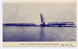
|-|Amtrak Old Saybrook – Old Lyme Bridge
Amtrak Old Saybrook – Old Lyme Bridge
The Amtrak Old Saybrook – Old Lyme Bridge is the last crossing of the Connecticut River before it reaches Long Island Sound. It is a Truss bridge with a bascule span, allowing boat traffic to go through. Its tracks are owned by Amtrak and used by trains on their Northeast Corridor and Shore Line...
|Amtrak
Amtrak
The National Railroad Passenger Corporation, doing business as Amtrak , is a government-owned corporation that was organized on May 1, 1971, to provide intercity passenger train service in the United States. "Amtrak" is a portmanteau of the words "America" and "track". It is headquartered at Union...
Northeast Corridor
Northeast Corridor
The Northeast Corridor is a fully electrified railway line owned primarily by Amtrak serving the Northeast megalopolis of the United States from Boston in the north, via New York to Washington, D.C. in the south, with branches serving other cities...
|rowspan=2|Old Saybrook
Old Saybrook, Connecticut
Old Saybrook is a town in Middlesex County, Connecticut, United States. The population was 10,367 at the 2000 census. It contains the incorporated borough of Fenwick, as well as the census-designated places of Old Saybrook Center and Saybrook Manor.-History:...
and Old Lyme
Old Lyme, Connecticut
Old Lyme is a town in New London County, Connecticut, United States. The Main Street of the town is a historic district. The town has long been a popular summer resort and artists' colony...
|
|41°18′39"N 72°20′57"W
|-
|Raymond E. Baldwin Bridge
Raymond E. Baldwin Bridge
The Baldwin Bridge is a concrete segmental bridge composed of eleven spans crossing the Connecticut River between Old Saybrook, Connecticut and Old Lyme, Connecticut. The bridge carries Interstate 95 and U.S. Route 1, with an average daily traffic of 82,500....
| I-95
Interstate 95 in Connecticut
Interstate 95, the main north–south Interstate Highway on the East Coast of the United States, runs in a general east–west compass direction for 111.57 miles in Connecticut from the Rhode Island state line to the New York State line. I-95 Southbound from East Lyme to the New York State...
 US 1
US 1U.S. Route 1 in Connecticut
In the U.S. state of Connecticut, U.S. Route 1 is a major east–west state highway along Long Island Sound. It has been replaced by Interstate 95 as a through route, which it closely parallels, and now primarily serves as a local business route...
|1948
(rebuilt in 1993)
|41°19′09"N 72°20′51"W
|-
|Chester–Hadlyme Ferry
|
 Route 148
Connecticut Route 148
Route 148 is a state highway in southern and southeastern Connecticut running from Route 79 in Killingworth to Route 82 in the village of Hadlyme...
|Chester
Chester, Connecticut
Chester is a town in Middlesex County, Connecticut, United States. The population was 3,743 at the 2000 census. The town center is also defined by the U.S. Census Bureau as a census-designated place .-Geography:...
and Lyme
Lyme, Connecticut
Lyme is a town in New London County, Connecticut, United States. The population was 2,016 at the 2000 census. Lyme and its neighboring town Old Lyme are the namesake for Lyme disease.-Geography:...
|1769
|41°25′11"N 72°25′50"W
|-
|East Haddam Bridge
East Haddam Bridge
The East Haddam Bridge is a steel, movable truss bridge composed of two main spans crossing the Connecticut River between Haddam, Connecticut and East Haddam, Connecticut. The bridge carries Route 82, with an average daily traffic of 11,600....
|
 Route 82
Connecticut Route 82
Route 82 is an east–west state highway in Connecticut running for from Route 9 in Chester to Route 2 and 32 in Norwich.- Route description:...
|Haddam
Haddam, Connecticut
Haddam is a town in Middlesex County, Connecticut, United States. The population was 7,157 at the 2000 census. The town was also home to the now decommissioned Connecticut Yankee Nuclear Reactor.-Geography:...
and East Haddam
East Haddam, Connecticut
East Haddam is a town in Middlesex County, Connecticut, United States. The population was 8,333 at the 2000 census.-Geography:According to the United States Census Bureau, the town has a total area of , of which, of it is land and of it is water....
|1913
|41°27′05"N 72°27′52"W
|-
|Providence and Worcester railroad bridge
Providence & Worcester railroad bridge
The Providence and Worcester Railroad Bridge is a swing truss bridge crossing the Connecticut River in Middletown, Connecticut. It carried the New York and Boston Air Line Railroad over the river to Portland, Connecticut. The bridge is used by the Providence & Worcester Railroad to serve two...
|
|rowspan=2|Middletown
Middletown, Connecticut
Middletown is a city located in Middlesex County, Connecticut, along the Connecticut River, in the central part of the state, 16 miles south of Hartford. In 1650, it was incorporated as a town under its original Indian name, Mattabeseck. It received its present name in 1653. In 1784, the central...
and Portland
Portland, Connecticut
Portland is a town in Middlesex County, Connecticut, United States. The population was 8,732 at the 2000 census. The town center is listed as a census-designated place . It is situated across the Connecticut River from Middletown....
|
|41°34′00"N 72°38′52"W
|-
|Arrigoni Bridge
Arrigoni Bridge
The Arrigoni Bridge carries Route 66 and Route 17 over Route 9 and across the Connecticut River, connecting Middletown, Connecticut to Portland, Connecticut...
|
 Route 17
 Route 66
|1938
|41°34′09"N 72°38′55"W
|-
|Rocky Hill – Glastonbury Ferry
|
 Route 160
Connecticut Route 160
Route 160 is a state highway in Connecticut running for from the Berlin Turnpike in Berlin to Route 17 in the South Glastonbury section of Glastonbury. The road crosses the Connecticut River on the Rocky Hill - Glastonbury Ferry...
|Rocky Hill
Rocky Hill, Connecticut
Rocky Hill is a town in Hartford County, Connecticut, United States. The population was 17,966 at the 2000 census. Rocky Hill was part of Wethersfield, the neighboring town to the north, until it was independently incorporated in 1849....
and Glastonbury
Glastonbury, Connecticut
Glastonbury is a town in Hartford County, Connecticut, United States, founded in 1693. The population was 31,876 at the 2000 census. The town was named after Glastonbury in Somerset, England. Glastonbury is located on the banks of the Connecticut River, 7 miles southeast of Hartford. The town...
|1655
|41°39′57"N 72°37′40"W
|-
|William H. Putnam Memorial Bridge
William H. Putnam Memorial Bridge
The Putnam Bridge is a bridge in the state of Connecticut carrying the Route 3 Expressway over the Connecticut River, connecting Interstate 91 in Wethersfield and Route 2 in Glastonbury...
|
 Route 3
|Wethersfield
Wethersfield, Connecticut
Wethersfield is a town in Hartford County, Connecticut, United States. Many records from colonial times spell the name Weathersfield, while Native Americans called it Pyquag...
and Glastonbury
Glastonbury, Connecticut
Glastonbury is a town in Hartford County, Connecticut, United States, founded in 1693. The population was 31,876 at the 2000 census. The town was named after Glastonbury in Somerset, England. Glastonbury is located on the banks of the Connecticut River, 7 miles southeast of Hartford. The town...
|1959
|41°42′51"N 72°38′27"W
|-
|Charter Oak Bridge
Charter Oak Bridge
The Charter Oak Bridge is one of the three highway bridges over the Connecticut River in Hartford, Connecticut. The twin steel stringer bridge carries the Route 15 and U.S. Route 5...
|
 US 5
US 5U.S. Route 5 in Connecticut
U.S. Route 5 , a north–south U.S. Highway that is generally paralleled by Interstate 91, begins at the city of New Haven in Connecticut and heads north through western Massachusetts and eastern Vermont to the international border with Canada...
 Route 15
|rowspan=4|Hartford
Hartford, Connecticut
Hartford is the capital of the U.S. state of Connecticut. The seat of Hartford County until Connecticut disbanded county government in 1960, it is the second most populous city on New England's largest river, the Connecticut River. As of the 2010 Census, Hartford's population was 124,775, making...
and East Hartford
East Hartford, Connecticut
East Hartford is a town in Hartford County, Connecticut, United States. The population was 51,252 at the 2010 census.-Geography:...
|1991
|41°45′11"N 72°39′18"W
|-
|Founders Bridge
Founders Bridge
The Founders Bridge is one of the three highway bridges over the Connecticut River in Hartford, Connecticut. The steel stringer bridge carries the Route 2 expressway, and also crosses over Interstate 91...
|
 Route 2
|1958
|41°45′56"N 72°39′55"W
|-
|Morgan G. Bulkeley Bridge
Bulkeley Bridge
The Bulkeley Bridge is a stone arch bridge composed of nine spans located in Hartford, Connecticut. The bridge carries Interstate 84, U.S. Route 6 and U.S. Route 44 across the Connecticut River, connecting Hartford to East Hartford...
|
.svg.png) I-84
I-84Interstate 84 in Connecticut
Interstate 84 is an East–West Interstate highway across the state of Connecticut into Danbury, Waterbury, Hartford and Union.-Route description:...
 US 6
US 6U.S. Route 6 in Connecticut
U.S. Route 6 is the portion of the cross-country U.S. Route 6 within the state of Connecticut. West of Hartford, the route either closely parallels or runs along Interstate 84. Interstate 84 has largely supplanted Route 6 as a through route in western Connecticut. East of Hartford, the route serves...
 US 44
US 44U.S. Route 44 in Connecticut
U.S. Route 44 is an east–west U.S. Highway running from Salisbury to Putnam.-Route description:From the New York state line at Salisbury to the Rhode Island state line at Putnam, US 44 runs for a total of in Connecticut. Most of US 44 is known in the state as the Jonathan Trumbull Highway...
|1906
|41°46′09"N 72°39′54"W
|-
|Connecticut Southern railroad bridge
Connecticut Southern railroad bridge
The Connecticut Southern Railroad bridge is a 5-span truss bridge connecting Hartford and East Hartford, Connecticut, over the Connecticut River. The bridge is 1,240 feet in length and 18.3 feet in width and was built ca. 1873 by the Hartford, Providence and Fishkill Railroad...
|
|
|41°46′35"N 72°39′27"W
|-
|Captain John Bissell Memorial Bridge
Bissell Bridge (Connecticut)
The Captain John Bissell Memorial Bridge carries I-291 over the Connecticut River, connecting the towns of Windsor, Connecticut and South Windsor, Connecticut. There is a pedestrian crossing on the bridge on the westbound side.-External links:...
|
 I-291
I-291Interstate 291 (Connecticut)
Interstate 291 is a short Interstate Highway in the state of Connecticut that starts at I-91 at its junction with Route 218 in Windsor and ends at I-84 in Manchester. It serves as a northeastern bypass of Hartford...
|Windsor
Windsor, Connecticut
Windsor is a town in Hartford County, Connecticut, United States, and was the first English settlement in the state. It lies on the northern border of Connecticut's capital, Hartford. The population was estimated at 28,778 in 2005....
and South Windsor
South Windsor, Connecticut
-History:In 1659, Thomas Burnham purchased the tract of land now covered by the towns of South Windsor and East Hartford from Tantinomo, chief sachem of the Podunk Indians. Burnham lived on the land and later willed it to his nine children...
|1958
|41°48′47"N 72°38′40"W
|-
|Dexter Coffin Bridge
Dexter Coffin Bridge
The Dexter Coffin Bridge is a crossing for Interstate 91 over the Connecticut River north of Hartford, Connecticut, connecting the towns of Windsor Locks, Connecticut and East Windsor, Connecticut-External links and references:...
|
 I-91
I-91Interstate 91 in Connecticut
Interstate 91 is a north–south Interstate Highway in the state of Connecticut. The interstate's southern end is in New Haven, Connecticut at Interstate 95.-Route description:...
|rowspan=2|Windsor Locks
Windsor Locks, Connecticut
Windsor Locks is a town located in Hartford County, Connecticut, United States. As of the 2000 census, its population was 12,043. It is the site of Bradley International Airport, which serves the Greater Hartford-Springfield region. It is also the site of the New England Air Museum...
and East Windsor
East Windsor, Connecticut
East Windsor is a town in Hartford County, Connecticut, United States. The population was 11,162 at the 2010 census.The town has five villages: Broad Brook, Melrose, Scantic, Warehouse Point and Windsorville.-Area:...
|1959
|41°55′00"N 72°37′22"W
|-
|Bridge Street Bridge
|
 Route 140
Connecticut Route 140
Route 140 is a state highway in Connecticut in the northeastern part of the Greater Hartford area. Route 140 is a main artery connecting the town of Ellington to Hartford.-Route description:...
|rebuilt 1992
|41°55′45"N 72°37′27"W
|-
|Amtrak/Springfield Terminal Railroad Bridge
Amtrak/Springfield Terminal Railroad Bridge
The Amtrak/Springfield Terminal Railroad Bridge, also known as Warehouse Point railroad bridge, is a rail girder bridge with a truss main span crossing over the Connecticut River, connecting the towns of Enfield, Connecticut and Suffield, Connecticut...
|Amtrak
Amtrak
The National Railroad Passenger Corporation, doing business as Amtrak , is a government-owned corporation that was organized on May 1, 1971, to provide intercity passenger train service in the United States. "Amtrak" is a portmanteau of the words "America" and "track". It is headquartered at Union...
New Haven – Springfield Line
|rowspan=4|Suffield
Suffield, Connecticut
Suffield is a town in Hartford County, Connecticut, United States. It had once been within the boundaries of Massachusetts. The town is located in the Connecticut River Valley with the town of Enfield neighboring to the east. In 1900, 3,521 people lived in Suffield; and in 1910, 3,841. As of the...
and Enfield
Enfield, Connecticut
Enfield is a town located in Hartford County, Connecticut, United States. The population was 45,212 at the 2000 census. It sits on the border with Longmeadow, Massachusetts and East Longmeadow, Massachusetts to the north, Somers to the east, East Windsor and Ellington to the south, and the...
|
|41°56′36"N 72°36′50"W
|-
|Enfield–Suffield Covered Bridge (destroyed 1900)
|
|1832
|41°58′30.34"N 72°36′22.31"W
|-
|Enfield–Suffield Veterans Bridge
|
 Route 190
Connecticut Route 190
Route 190 is a state route in the northern part of the U.S. state of Connecticut. It starts at Route 75 in the town of Suffield and proceeds eastward across the Connecticut River through the towns of Enfield, Somers, and Stafford. It ends at Route 171, in the town of Union. Route 190 was...
|1966
|41°59′23"N 72°36′13"W
|-
|Suffield and Thompsonville Bridge
Suffield and Thompsonville Bridge
The Suffield and Thompsonville Bridge was a 5-span iron truss bridge over the Connecticut River located between present day Suffield, Connecticut and Thompsonville, Connecticut . It connected Burbank Avenue in Suffield with Main Street in Thompsonville...
(demolished 1971)
|
|1893
|41°59′57"N 72°36′25.56"W
|-
!colspan=6|
Massachusetts
|-|Julia B. Buxton Bridge (South End Bridge)
|
US 5U.S. Route 5
U.S. Route 5 is a north–south United States highway running through the New England states of Connecticut, Massachusetts, and Vermont. Significant cities along the route include New Haven, Connecticut; Hartford, Connecticut; and Springfield, Massachusetts. From Hartford northward to St...
|Agawam
Agawam, Massachusetts
The Town of Agawam is a city in Hampden County, Massachusetts, United States. The population was 28,438 at the 2010 census. Agawam sits on the western side of the Connecticut River, directly across from the City of Springfield, Massachusetts...
and Springfield
Springfield, Massachusetts
Springfield is the most populous city in Western New England, and the seat of Hampden County, Massachusetts, United States. Springfield sits on the eastern bank of the Connecticut River near its confluence with three rivers; the western Westfield River, the eastern Chicopee River, and the eastern...
|1954
|42°04′53"N 72°34′58"W
|-
|Memorial Bridge
Memorial Bridge (Massachusetts)
The Memorial Bridge is a reinforced-concrete arch bridge that spans the Connecticut River between Springfield, Massachusetts and West Springfield, Massachusetts, constructed in 1922. The bridge is owned by Massachusetts Highway Department and is located on Massachusetts Route 147...
|
 Route 147
Massachusetts Route 147
Route 147 is a west–east state highway in Massachusetts, serving the cities of Agawam and West Springfield. It follows the easternmost few miles of the former route of Route 57 before it was moved onto a limited access freeway a mile south, the Henry E...
|rowspan=4|West Springfield
West Springfield, Massachusetts
The Town of West Springfield is a city in Hampden County, Massachusetts, United States. It is part of the Springfield, Massachusetts Metropolitan Statistical Area. The population was 28,391 at the 2010 census...
and Springfield
Springfield, Massachusetts
Springfield is the most populous city in Western New England, and the seat of Hampden County, Massachusetts, United States. Springfield sits on the eastern bank of the Connecticut River near its confluence with three rivers; the western Westfield River, the eastern Chicopee River, and the eastern...
|1922
|42°05′56"N 72°35′42"W
|-
|Old Toll Bridge (demolished)
|
|1816
|42°5′59.68"N 72°35′46.47"W
|-
|CSX Berkshire rail bridge
|CSX Berkshire Subdivision
Berkshire Subdivision
The Berkshire Subdivision is a railroad line owned by CSX Transportation in the U.S. states of Massachusetts and New York. The line runs from near Springfield, Massachusetts west to Schodack, New York along a former New York Central Railroad line. Its east end is in Wilbraham, east of Springfield,...
|1873
|42°06′05"N 72°35′57"W
|-
|North End Bridge
|
 US 20
US 20U.S. Route 20
U.S. Route 20 is an east–west United States highway. As the "0" in its route number implies, US 20 is a coast-to-coast route. Spanning , it is the longest road in the United States, and the route sparsely parallels Interstate 90...
|1924
|42°06′31"N 72°36′51"W
|-
|I-91 bridge
|
I-91Interstate 91
Interstate 91 is an Interstate Highway in the New England region of the United States. It provides the primary north–south thoroughfare in the western part of New England...
|rowspan=3|West Springfield
West Springfield, Massachusetts
The Town of West Springfield is a city in Hampden County, Massachusetts, United States. It is part of the Springfield, Massachusetts Metropolitan Statistical Area. The population was 28,391 at the 2010 census...
and Chicopee
Chicopee, Massachusetts
Chicopee is a city located on the Connecticut River in Hampden County, Massachusetts, United States of America. It is part of the Springfield, Massachusetts Metropolitan Statistical Area. As of the 2010 census, the city had a total population of 55,298, making it the second largest city in...
|1966
|42°08′07"N 72°36′55"W
|-
|Chicopee – West Springfield Bridge (demolished 1987)
|
|
|42°8′38.39"N 72°37′7.11"W
|-
|Massachusetts Turnpike bridge
|
 I-90
I-90|1957
|42°09′14"N 72°37′40"W
|-
|I-391 bridge
|
 I-391
I-391Interstate 391
Interstate 391 is an Auxiliary Interstate Highway located entirely within the U.S. State of Massachusetts. It runs from the I-91/I-391 interchange in Chicopee to the center of Holyoke, a distance of about . It runs near the Connecticut River throughout its journey in Chicopee, and crosses into...
|rowspan=3|Holyoke
Holyoke, Massachusetts
Holyoke is a city in Hampden County, Massachusetts, United States, between the western bank of the Connecticut River and the Mount Tom Range of mountains. As of the 2010 Census, the city had a population of 39,880...
and Chicopee
Chicopee, Massachusetts
Chicopee is a city located on the Connecticut River in Hampden County, Massachusetts, United States of America. It is part of the Springfield, Massachusetts Metropolitan Statistical Area. As of the 2010 census, the city had a total population of 55,298, making it the second largest city in...
|1979
|42°11′24"N 72°36′36"W
|-
|Willimansett Bridge
Willimansett Bridge
The Willimansett Bridge is a steel truss bridge over the Connecticut River located between Chicopee, Massachusetts and Holyoke, Massachusetts. It carries Massachusetts state routes 116 and 141.- History :...
|
 Route 116
Massachusetts Route 116
Route 116 is a south–north state highway in Massachusetts. The route runs from Springfield through mill towns, college towns and rural towns, crossing the Connecticut River three times before finally ending in Adams.-Route description:...
 Route 141
Massachusetts Route 141
Route 141 is a west–east state highway in the U.S. state of Massachusetts. Its western terminus is at Route 10 in Easthampton. Its eastern terminus is at U.S...
|1891
|42°11′42"N 72°36′05"W
|-
|Springfield Terminal railroad bridge
|
|
|42°11′43"N 72°36′02"W
|-
|Vietnam Memorial Bridge
Vietnam Memorial Bridge
The Vietnam Memorial Bridge is a girder bridge that spans the Connecticut River between South Hadley and Holyoke, Massachusetts. It was built in 1889 by New Jersey Steel and Iron Company and was designed by Edward S...
|
Route 116Massachusetts Route 116
Route 116 is a south–north state highway in Massachusetts. The route runs from Springfield through mill towns, college towns and rural towns, crossing the Connecticut River three times before finally ending in Adams.-Route description:...
|rowspan=2|Holyoke
Holyoke, Massachusetts
Holyoke is a city in Hampden County, Massachusetts, United States, between the western bank of the Connecticut River and the Mount Tom Range of mountains. As of the 2010 Census, the city had a population of 39,880...
and South Hadley
South Hadley, Massachusetts
South Hadley is a town in Hampshire County, Massachusetts, United States. The population was 17,514 at the 2010 census. It is part of the Springfield, Massachusetts Metropolitan Statistical Area....
|1990
|42°12′42"N 72°35′46"W
|-
|Joseph E. Muller Bridge
Joseph E. Muller Bridge
The Joseph E. Muller Bridge is a crossing of the Connecticut River in Western Massachusetts, connecting the towns of Holyoke and South Hadley. The bridge carries Route 202.- History and construction of the bridge :...
|
 US 202
U.S. Route 202
U.S. Route 202 is a highway stretching from Delaware to Maine, also passing through the states of Pennsylvania, New Jersey, New York, Connecticut, Massachusetts, and New Hampshire....
|1958
|42°12′58"N 72°36′28"W
|-
|Northampton Toll Bridge
|
|rowspan=3|Northampton
Northampton, Massachusetts
The city of Northampton is the county seat of Hampshire County, Massachusetts, United States. As of the 2010 census, the population of Northampton's central neighborhoods, was 28,549...
and Hadley
Hadley, Massachusetts
Hadley is a town in Hampshire County, Massachusetts. The population was 4,793 at the 2000 census. It is part of the Springfield, Massachusetts Metropolitan Statistical Area. The area around Hampshire Mall and Mountain Farms Mall along Route 9 is a major shopping destination for the surrounding...
|1808
|42°20′11"N 72°37′04"W
|-
|Calvin Coolidge Bridge
Calvin Coolidge Bridge
The Calvin Coolidge Memorial Bridge is a major crossing of the Connecticut River in western Massachusetts, connecting the towns of Northampton and Hadley. The bridge carries Route 9 across the river, where it connects to Interstate 91...
|
 Route 9
|1937
|42°20′11"N 72°37′04"W
|-
|Norwottuck Rail Trail Bridge
Norwottuck Rail Trail Bridge
The Norwottuck Rail Trail Bridge is a former crossing of Boston and Maine Railroad over the Connecticut River in western Massachusetts, connecting the towns of Northampton and Hadley, currently used for bicycle and foot traffic.-History and construction of the bridge:The Norwottuck Rail Trail...
|Norwottuck Rail Trail
Norwottuck Rail Trail
The Norwottuck Rail Trail is a combination bicycle/pedestrian paved right-of-way running from Northampton, Massachusetts, through Hadley and Amherst, to Belchertown, Massachusetts. It opened in 1992. No motor vehicles or horses are allowed.- Use :...
|1887
|42°20′14"N 72°37′07"W
|-
|Hatfield Bridge (dismantled 1823)
|Toll Bridge passed by state legislature March 8, 1803 without funding. Town purchase it by lottery, was completed October 20, 1807 and dismantled on July 7, 1823. Bridge was located on Bridge Lane, Hatfield, MA
|Hatfield
Hatfield, Massachusetts
Hatfield is a town in Hampshire County, Massachusetts, United States. The population was 3,249 at the 2000 census. It is part of the Springfield, Massachusetts Metropolitan Statistical Area....
and Hadley
Hadley, Massachusetts
Hadley is a town in Hampshire County, Massachusetts. The population was 4,793 at the 2000 census. It is part of the Springfield, Massachusetts Metropolitan Statistical Area. The area around Hampshire Mall and Mountain Farms Mall along Route 9 is a major shopping destination for the surrounding...
|1807
|42°21′55.44"N 72°35′21.65"W
|-
|Sunderland Bridge
Sunderland Bridge (Massachusetts)
The Sunderland Bridge is a crossing over the Connecticut River in western Massachusetts, connecting the towns of South Deerfield and Sunderland, carrying Massachusetts Route 116.-History and construction of the bridge:...
|
Route 116Massachusetts Route 116
Route 116 is a south–north state highway in Massachusetts. The route runs from Springfield through mill towns, college towns and rural towns, crossing the Connecticut River three times before finally ending in Adams.-Route description:...
|Deerfield
Deerfield, Massachusetts
Deerfield is a town in Franklin County, Massachusetts, United States. The population was 4,750 as of the 2000 census. Deerfield is part of the Springfield, Massachusetts Metropolitan Statistical Area in Western Massachusetts, lying only north of the city of Springfield.Deerfield includes the...
and Sunderland
Sunderland, Massachusetts
Sunderland is a town in Franklin County, Massachusetts, part of the Pioneer Valley. The population was 3,777 as of the 2000 census. It is part of the Springfield, Massachusetts Metropolitan Statistical Area....
|1937
|42°28′03"N 72°35′06"W
|-
|Springfield Terminal railroad bridge
Springfield Terminal railroad bridge, Deerfield
The Springfield Terminal railroad bridge in Deerfield, Massachusetts is a three-span deck-truss bridge which crosses the Connecticut River.- History :...
|
|Deerfield
Deerfield, Massachusetts
Deerfield is a town in Franklin County, Massachusetts, United States. The population was 4,750 as of the 2000 census. Deerfield is part of the Springfield, Massachusetts Metropolitan Statistical Area in Western Massachusetts, lying only north of the city of Springfield.Deerfield includes the...
and Montague
Montague, Massachusetts
Montague is a town in Franklin County, Massachusetts, United States. The population was 8,489 at the 2000 census. It is part of the Springfield, Massachusetts metropolitan statistical area....
|
|42°33′44"N 72°33′22"W
|-
|Canalside Rail Trail Bridge
Canalside Rail Trail Bridge
The Canalside Rail Trail Bridge is a former New York, New Haven and Hartford Railroad rail bridge across the Connecticut River between...
|
|Deerfield
Deerfield, Massachusetts
Deerfield is a town in Franklin County, Massachusetts, United States. The population was 4,750 as of the 2000 census. Deerfield is part of the Springfield, Massachusetts Metropolitan Statistical Area in Western Massachusetts, lying only north of the city of Springfield.Deerfield includes the...
and Montague
Montague, Massachusetts
Montague is a town in Franklin County, Massachusetts, United States. The population was 8,489 at the 2000 census. It is part of the Springfield, Massachusetts metropolitan statistical area....
|c1880
|42°34′45.30"N 72°34′29.53"W
|-
|Montague City Covered Bridge (destroyed 1936)
|
|rowspan=4|Greenfield
Greenfield, Massachusetts
Greenfield is a city in Franklin County, Massachusetts, United States. The population was 17,456 at the 2010 census. It is the county seat of Franklin County. Greenfield is home to Greenfield Community College, the Pioneer Valley Symphony Orchestra, and the Franklin County Fair...
and Montague
Montague, Massachusetts
Montague is a town in Franklin County, Massachusetts, United States. The population was 8,489 at the 2000 census. It is part of the Springfield, Massachusetts metropolitan statistical area....
|
|42°34′49.1"N 72°34′44.9"W (approx.)
|-
|Montague trolley bridge (destroyed 1936)
|
|
|42°34′49.1"N 72°34′45.9"W (approx.)
|-
|General Pierce Bridge
General Pierce Bridge
The General Pierce Bridge is a steel truss road bridge over the Connecticut River between Greenfield, Massachusetts and Montague, Massachusetts carrying Montague City Road.It is currently being scheduled for major repairs...
|
|1947
|42°34′49"N 72°34′47"W
|-
|Turners Falls Road Bridge
Turners Falls Road Bridge
The Turners Falls Road Bridge is a concrete and steel road bridge over the Connecticut River in the U.S. state of Massachusetts. It carries Turners Falls Road and connects the town center of Greenfield and the village of Turners Falls .- History :The current bridge is the second on this site...
|
|1936
|42°36′33"N 72°33′41"W
|-
|Gill–Montague Bridge
|
|Gill
Gill, Massachusetts
Gill is a town in Franklin County, Massachusetts, USA. The population was 1,363 at the 2000 census. It is part of the Springfield, Massachusetts Metropolitan Statistical Area...
and Montague
Montague, Massachusetts
Montague is a town in Franklin County, Massachusetts, United States. The population was 8,489 at the 2000 census. It is part of the Springfield, Massachusetts metropolitan statistical area....
|1937
|42°36′40"N 72°33′11"W
|-
|French King Bridge
French King Bridge
The French King Bridge is a three-span "cantilever arch" style bridge crossing the Connecticut River on the border of the towns of Erving and Gill, Massachusetts...
|
 Route 2
|Gill
Gill, Massachusetts
Gill is a town in Franklin County, Massachusetts, USA. The population was 1,363 at the 2000 census. It is part of the Springfield, Massachusetts Metropolitan Statistical Area...
and Erving
Erving, Massachusetts
Erving is a town in Franklin County, Massachusetts, United States. The population was 1,467 at the 2000 census. It is part of the Springfield, Massachusetts metropolitan statistical area.-History:...
|1931
|42°35′52"N 72°29′48"W
|-
|Route 10 bridge
Route 10 bridge, Northfield, Massachusetts
The Route 10 bridge, also known as Bennett's Meadow Bridge is a steel stringer bridge crossing the Connecticut River in the town of Northfield, Massachusetts. The bridge carries state highway Route 10 and was built in 1969.- History :...
|
 Route 10
Massachusetts Route 10
Massachusetts Route 10 is a north–south state highway that runs from the state line at Southwick to the state line at Northfield.-Route description:Route 10 crosses the border from Granby, Connecticut into Southwick, Massachusetts, overlapped with US 202...
|rowspan=3|Northfield
Northfield, Massachusetts
Northfield is a town in Franklin County, Massachusetts, United States. The population was 2,951 at the 2000 census. It is part of the Springfield, Massachusetts Metropolitan Statistical Area...
|1969
|42°41′00"N 72°28′18"W
|-
|Rail bridge
Rail Bridge, Northfield, Massachusetts
The rail crossing of the Connecticut River at this location originates from the Vermont and Massachusetts Railroad. The V&MRR was chartered in 1844 and completed an extension between Millers Falls, Massachusetts and Brattleboro, Vermont by 1850. Alvah Crocker, a paper and railroad magnate and U.S....
|New England Central Railroad and Amtrak
|1903
|42°42′22.40"N 72°27′33"W
|-
|Schell Bridge
Schell Bridge
The Schell Bridge is a steel Pennsylvania truss bridge across the Connecticut River in the town of Northfield, Massachusetts. The bridge was closed in 1987, and steel plates were welded across each portal to prevent access...
(closed)
|
|1903
|42°42′44"N 72°27′12"W
|-
!colspan=6|
Vermont – New Hampshire
|-|Fort Hill Branch rail bridge
|
|rowspan=2|Brattleboro
Brattleboro, Vermont
Brattleboro, originally Brattleborough, is a town in Windham County, Vermont, United States, located in the southeast corner of the state, along the state line with New Hampshire. The population was 12,046 at the 2010 census...
and Hinsdale
Hinsdale, New Hampshire
Hinsdale is a town in Cheshire County, New Hampshire, United States. The population was 4,046 at the 2010 census. Hinsdale is home to part of Pisgah State Park in the northeast, and part of Wantastiquet Mountain State Forest in the northwest....
|
|42°50′16.38"N 72°32′46.21"W
|-
|VT/NH Route 119 bridge
|
 VT 119
Vermont Route 119
Vermont Route 119 is a very short east–west state highway located within Brattleboro in Windham County, Vermont, United States. It is the second shortest numbered highway in Vermont, after Vermont Route 26...
 NH 119
New Hampshire Route 119
New Hampshire Route 119 is a long east–west state highway in Cheshire County in southwestern New Hampshire. The highway runs from the Massachusetts border in New Ipswich to Hinsdale on the Vermont border....
|1920
|42°51′05"N 72°33′10"W
|-
|United States Navy Seabees Bridge
United States Navy Seabees Bridge
The United States Navy Seabees Bridge is a through steel two-hinged arch bridge over the Connecticut River located between Brattleboro, Vermont and Chesterfield, New Hampshire. It carries VT 9 / NH 9.- History and construction :...
|
 VT 9
VT 9 NH 9
NH 9|Brattleboro
Brattleboro, Vermont
Brattleboro, originally Brattleborough, is a town in Windham County, Vermont, United States, located in the southeast corner of the state, along the state line with New Hampshire. The population was 12,046 at the 2010 census...
and Chesterfield
Chesterfield, New Hampshire
Chesterfield is a town in Cheshire County, New Hampshire, United States. The population was 3,604 at the 2010 census. It includes the village of Spofford...
|rebuilt 2003
|42°53′02"N 72°33′07"W
|-
|Route 123 bridge
|
 VT 123
 NH 123
New Hampshire Route 123
New Hampshire Route 123 is a long secondary north–south state highway in southwestern New Hampshire. The southern terminus of the route is at the Massachusetts state line in Mason where, as Valley Road, the road continues as an unnumbered local road in the town of Townsend...
|Westminster and Walpole
Walpole, New Hampshire
Walpole is a town in Cheshire County, New Hampshire, United States. The population was 3,734 at the 2010 census.The town's central settlement, where 605 people resided at the 2010 census, is defined as the Walpole census-designated place , and is east of New Hampshire Route 12...
|1910
|43°05′04"N 72°26′00"W
|-
|Vilas Bridge
|
|rowspan=4|Bellows Falls
Bellows Falls, Vermont
Bellows Falls is an incorporated village located in the town of Rockingham in Windham County, Vermont, United States. The population was 3,165 at the 2000 census...
and North Walpole
North Walpole, New Hampshire
North Walpole is a census-designated place in the town of Walpole in Cheshire County, New Hampshire. It had a population of 828 at the 2010 census....
|1930
|43°08′07"N 72°26′25"W
|-
|Stone Arch Bridge
|Vermont Rail (Green Mountain)
|
|43°08′09"N 72°26′25"W
|-
|New England Central railroad bridge
|
|
|43°08′17"N 72°26′48"W
|-
|Arch Bridge
Arch Bridge (Bellows Falls)
The Bellows Falls Arch Bridge was a three-hinged steel through arch bridge over the Connecticut River between Bellows Falls, Vermont and North Walpole, New Hampshire...
|
|1983
|43°08′17"N 72°26′54"W
|-
|Cheshire Bridge
|
 VT 11
VT 11Vermont Route 11
Vermont Route 11 is an east–west state highway in Vermont, United States. The western end of the highway is at Vermont Route 7A in Manchester. The eastern end is at the New Hampshire border at the Cheshire Bridge over the Connecticut River, connecting Springfield, Vermont and Charlestown, New...
 NH 11
NH 11New Hampshire Route 11
New Hampshire Route 11 is a long east–west state highway in New Hampshire, running westward along the southern shore of Lake Winnipesaukee. Its eastern terminus is at the Maine state line in the city of Rochester, where it continues north as Maine State Route 11. U.S. Route 202, which runs...
|Springfield
Springfield, Vermont
Springfield is a town in Windsor County, Vermont, United States. The population was 9,373 at the 2010 census.-History:One of the New Hampshire grants, the township was chartered on August 20, 1761 by Governor Benning Wentworth and awarded to Gideon Lyman and 61 others...
and Charlestown
Charlestown, New Hampshire
Charlestown is a town in Sullivan County, New Hampshire, United States. The population was 5,114 at the 2010 census. The town is home to Hubbard State Forest and the headquarters of the Student Conservation Association....
|?
|43°15′37"N 72°25′38"W
|-
|Route 12 bridge
|
 VT 12
VT 12Vermont Route 12
Vermont Route 12 is a north-south state highway in Vermont that runs from Weathersfield to Morrisville.-Route description:Route 12 begins at the New Hampshire state line on the Connecticut River in the town of Weathersfield. It continues north along the west bank of the Connecticut River,...
 NH 12
NH 12New Hampshire Route 12
New Hampshire Route 12 is a north-south state highway running across the western portion of New Hampshire from the Massachusetts state line to the Vermont state line at the Connecticut River.-Route description:...
|Ascutney
Ascutney, Vermont
Ascutney is an unincorporated village and census-designated place in the town of Weathersfield, Windsor County, Vermont, United States. It is located in the northeastern section of Weathersfield, in the portion of that town adjacent to Mount Ascutney, after which the village is...
and Claremont
Claremont, New Hampshire
There were 5,685 households out of which 27.4% had children under the age of 18 living with them, 45.5% were married couples living together, 10.3% had a female householder with no husband present, and 39.7% were non-families. 32.2% of all households were made up of individuals and 14.7% had...
|1969
|43°24′11"N 72°24′01"W
|-
|New England Central railroad bridge
|
|rowspan=2|Windsor
Windsor, Vermont
Windsor is a town in Windsor County, Vermont, United States. The population was 3,756 at the 2000 census.-History:One of the New Hampshire grants, Windsor was chartered as a town on July 6, 1761 by Colonial Governor Benning Wentworth. It was first settled in August 1764 by Captain Steele Smith and...
and Cornish
Cornish, New Hampshire
Cornish is a town in Sullivan County, New Hampshire, United States. The population was 1,640 at the 2010 census. Cornish has three covered bridges. Each August, it is home to the Cornish Fair.-History:...
|
|43°28′11"N 72°23′19"W
|-
|Cornish–Windsor Covered Bridge
|
|1866
|43°28′25"N 72°23′01"W
|-
|I-89 bridge
|
 I-89
I-89Interstate 89
Interstate 89 is an interstate highway in the New England region of the United States travelling between Bow, New Hampshire and Highgate Springs, Vermont. As with all odd-numbered primary interstates, I-89 is signed as a north–south highway...
|Hartford
Hartford, Vermont
Hartford is a town in Windsor County in the U.S. state of Vermont. It is located on the New Hampshire border, at the intersection of Interstates 89 and 91. It is the site of the confluence of the White River and the Connecticut River; the Ottauquechee River also flows through the town...
and Lebanon
West Lebanon, New Hampshire
West Lebanon, New Hampshire, is a district within the city of Lebanon on the Connecticut River. The area contains a major shopping plaza strip along New Hampshire Route 12A, serving the Upper Valley communities along Interstates 89 and 91...
|1966
|43°38′03"N 72°19′43"W
|-
|Railroad bridge
|
|rowspan=2|White River Junction
White River Junction, Vermont
White River Junction is an unincorporated village and census-designated place in the town of Hartford in Windsor County, Vermont, United States...
and West Lebanon
West Lebanon, New Hampshire
West Lebanon, New Hampshire, is a district within the city of Lebanon on the Connecticut River. The area contains a major shopping plaza strip along New Hampshire Route 12A, serving the Upper Valley communities along Interstates 89 and 91...
|
|43°38′49"N 72°18′48"W
|-
|US-4 bridge
|
 US 4
US 4U.S. Route 4
U.S. Route 4 is a long United States highway that runs from East Greenbush, New York, in the west to Portsmouth, New Hampshire, in the east, traversing through Vermont.In New York, US 4 is signed north–south to reflect its alignment in the state...
|1936
|43°39′02"N 72°18′51"W
|-
|Ledyard Bridge
Ledyard Bridge
The Ledyard Bridge crosses the Connecticut River to connect Hanover, New Hampshire to Norwich, Vermont. It is the third bridge at this crossing to bear the name of the adventurer John Ledyard.-History:...
|
 VT 10A
 NH 10A
New Hampshire Route 10A
Route 10A is a long highway in the states of Vermont and New Hampshire. The route begins at New Hampshire Route 10 in Hanover, New Hampshire and ends at Interstate 91 and U.S. Route 5 in the town of Norwich, Vermont...
|Norwich
Norwich, Vermont
Norwich is a town in Windsor County, Vermont, United States, located along the Connecticut River opposite Hanover, New Hampshire. The population was 3,544 at the 2000 census....
and Hanover
Hanover, New Hampshire
Hanover is a town along the Connecticut River in Grafton County, New Hampshire, United States. The population was 11,260 at the 2010 census. CNN and Money magazine rated Hanover the sixth best place to live in America in 2011, and the second best in 2007....
|1998
|43°42′13"N 72°17′59"W
|-
|Route 113 bridge
|
 VT 113
Vermont Route 113
Vermont Route 113 is a state highway in eastern Vermont in the United States. It runs south and east from an intersection with Vermont Route 110 in Chelsea to the New Hampshire border in Thetford...
East Thetford Road
|East Thetford
Thetford, Vermont
Thetford is a town in Orange County, Vermont, United States in the Connecticut River Valley. The population was 2,617 at the 2000 census. Villages within the town include East Thetford, North Thetford, Thetford Hill, Thetford Center, Rices Mills and Post Mills. The town office is in Thetford...
and Lyme
Lyme, New Hampshire
Lyme is a town in Grafton County, New Hampshire, United States. The population was 1,716 at the 2010 census. Lyme is home to the Chaffee Natural Area. The Dartmouth Skiway is in the eastern part of town, near the village of Lyme Center...
|1937
|43°48′43"N 72°10′59"W
|-
|Morey Memorial Bridge
|
 VT 25A
 NH 25A
|Fairlee
Fairlee, Vermont
-Notable people:* Milton Friedman, economist, former resident of Ely* Richard W. Mallary, congressman* Samuel Morey, inventor* George W. Morrison, congressman* Nathaniel Niles, politician* Stephen Thomas, politician and brigadier generalHelen Gahagan Douglas...
and Orford
Orford, New Hampshire
Orford is a town in Grafton County, New Hampshire, United States. The population was 1,237 at the 2010 census. The Appalachian Trail crosses in the east.-History:...
|1937
|43°54′25"N 72°08′22"W
|-
|Route 25 bridge
|
 VT 25
VT 25Vermont Route 25
Vermont Route 25 is a state highway in Orange County, Vermont, United States. It begins at the New Hampshire state line in Bradford, continuing across the Connecticut River as New Hampshire Route 25, and ends in Orange at U.S. Route 302....
 NH 25
NH 25New Hampshire Route 25
New Hampshire Route 25 is a long east–west state highway in New Hampshire. It runs completely across the state from Vermont to Maine.The western terminus of Route 25 is at the Vermont state line on the Connecticut River in Piermont, where the road continues west as Vermont Route 25...
|Bradford
Bradford, Vermont
Bradford is a town in Orange County, Vermont, United States. The population was 2,619 at the 2000 census.-History:The first settler was John Hosmer in 1765...
and Piermont
Piermont, New Hampshire
Piermont is a town in Grafton County, New Hampshire, United States. The population was 790 at the 2010 census. It is home to several summer camps.-History:...
|1929
|43°58′40"N 72°06′43"W
|-
|Bedell Covered Bridge
Bedell Covered Bridge
The Bedell Bridge was a Burr truss covered bridge that spanned the Connecticut River between Newbury, Vermont and Haverhill, New Hampshire. Until its most recent destruction in 1979, it was the second longest covered bridge in the United States.- History :...
(destroyed by wind, 1979)
|
|South Newbury
Newbury, Vermont
Newbury could be either of the following places in the U.S. state of Vermont:*Newbury , Vermont*Newbury , Vermont...
and Haverhill
Haverhill, New Hampshire
Haverhill is a town in Grafton County, New Hampshire, United States. The population was 4,697 at the 2010 census. Haverhill includes the villages of Woodsville, Pike, and North Haverhill, the historic town center at Haverhill Corner, and the district of Mountain Lakes...
|1805, 1823, 1862, 1866, 1979
|44°02′43"N 72°04′27"W
|-
|Newbury Crossing Road
|
|Newbury
Newbury, Vermont
Newbury could be either of the following places in the U.S. state of Vermont:*Newbury , Vermont*Newbury , Vermont...
and Haverhill
Haverhill, New Hampshire
Haverhill is a town in Grafton County, New Hampshire, United States. The population was 4,697 at the 2010 census. Haverhill includes the villages of Woodsville, Pike, and North Haverhill, the historic town center at Haverhill Corner, and the district of Mountain Lakes...
|1970
|44°03′58"N 72°03′05"W
|-
|Ranger Bridge
|
 US 302
U.S. Route 302
U.S. Route 302 is a spur of U.S. Route 2. It currently runs 171 miles north from Portland, Maine, at U.S. Route 1, to Montpelier, Vermont, at US 2...
|rowspan=2|Wells River
Wells River, Vermont
Wells River is a village in the town of Newbury in Orange County, Vermont, United States. The population was 325 at the 2000 census. The village center is located at the junction of U.S...
and Woodsville
Woodsville, New Hampshire
Woodsville is a census-designated place in the town of Haverhill in Grafton County, New Hampshire, U.S., along the Connecticut River at the mouth of the Ammonoosuc River. The population was 1,126 at the 2010 census...
|1923
|44°09′14"N 72°02′27"W
|-
|Wells River Bridge (closed)
|Boston and Maine Corporation (railroad)
|
|44°09′15"N 72°02′26"W
|-
|Frazier Road
|
|rowspan=2|McIndoe Falls
Barnet, Vermont
Barnet is a town in Caledonia County, Vermont, United States. The population was 1,690 at the 2000 census. Barnet contains the locations of Barnet Center, East Barnet, McIndoe Falls, Mosquitoville, Passumpsic and West Barnet.-Geography:...
and Monroe
Monroe, New Hampshire
Monroe is a town in Grafton County, New Hampshire, United States. The population was 788 at the 2010 census. The town is located along a bend of the Connecticut River, across from Barnet, Vermont...
|1937
|44°15′42"N 72°03′32"W
|-
|Barnet Road Bridge
|
|1930
|44°17′13"N 72°03′25"W
|-
|I-93 bridge
|
 I-93
I-93Interstate 93
Interstate 93 is an Interstate Highway in the New England section of the United States. Its southern terminus is in Canton, Massachusetts, in the Boston metropolitan area, at Interstate 95; its northern terminus is near St. Johnsbury, Vermont, at Interstate 91...
|rowspan=2|Waterford
Waterford, Vermont
Waterford is a town in Caledonia County, Vermont, United States. The population was 1,104 at the 2000 census.The town was originally called Littleton but the name was changed to Waterford in 1797.-Geography:...
and Littleton
Littleton, New Hampshire
Littleton is a town in Grafton County, New Hampshire, United States. The population was 5,928 at the 2010 census. Situated at the edge of the White Mountains, Littleton is bounded on the northwest by the Connecticut River....
|1976, 1981
|44°20′34"N 71°53′27"W
|-
|Route 18 bridge
|
 VT 18
VT 18Vermont Route 18
Vermont Route 18 is a state highway in Caledonia County, Vermont, United States. It runs southeast from the town of St. Johnsbury to the New Hampshire state line, continuing there as New Hampshire Route 18...
 NH 18
NH 18New Hampshire Route 18
New Hampshire Route 18 is a long north–south state highway in New Hampshire. Its northern terminus is at the Vermont state line in the town of Littleton, where the road continues north as Vermont Route 18. The southern terminus of NH 18 is at an interchange with Interstate 93 and U.S...
|1934
|44°20′33"N 71°53′20"W
|-
|Gilman Road
|
|rowspan=2|Gilman
Concord, Vermont
Concord is a town in Essex County, Vermont, United States. The population was 1,196 at the 2000 census. It is part of the Berlin, NH–VT Micropolitan Statistical Area, and contains the villages of North Concord and Miles Pond.- History :...
and Dalton
Dalton, New Hampshire
Dalton is a town in Coos County, New Hampshire, United States. The population was 979 at the 2010 census. It is part of the Berlin, NH–VT Micropolitan Statistical Area.- History :...
|reconstructed 1997
|44°24′39"N 71°43′23"W
|-
|old Gilman Road
|
|pedestrian traffic only
|44°24′40.34"N 71°43′21.45"W
|-
|Twin State railroad bridge
|
|South Lunenburg and Dalton
Dalton, New Hampshire
Dalton is a town in Coos County, New Hampshire, United States. The population was 979 at the 2010 census. It is part of the Berlin, NH–VT Micropolitan Statistical Area.- History :...
|
|44°25′38"N 71°40′35"W
|-
|Mount Orne Covered Bridge
Mount Orne Covered Bridge
The Mount Orne Bridge is a wooden Howe truss bridge over the Connecticut River located between Lancaster, New Hampshire and Lunenburg, Vermont.- History :...
|
|Lunenburg and South Lancaster
Lancaster, New Hampshire
Lancaster is a town in Coos County, New Hampshire, USA, on the Connecticut River named after Lancaster, England. As of the 2010 census, the town population was 3,507, the second largest in the county after Berlin. It is the county seat of Coos County and gateway to the Great North Woods Region...
|1911
|44°27′36"N 71°39′10"W
|-
|Route 2 bridge
|
 US 2
US 2U.S. Route 2
U.S. Route 2 is an east–west U.S. Highway spanning across the northern continental United States. US 2 consists of two segments connected by various roadways in southern Canada...
|Guildhall
Guildhall, Vermont
-External links:* http://www.flickr.com/photos/dougtone/sets/72157624844998996/with/4943890976/...
and Lancaster
Lancaster, New Hampshire
Lancaster is a town in Coos County, New Hampshire, USA, on the Connecticut River named after Lancaster, England. As of the 2010 census, the town population was 3,507, the second largest in the county after Berlin. It is the county seat of Coos County and gateway to the Great North Woods Region...
|1950
|44°29′46"N 71°35′39"W
|-
|Guildhall Road
|
|Guildhall
Guildhall, Vermont
-External links:* http://www.flickr.com/photos/dougtone/sets/72157624844998996/with/4943890976/...
and Northumberland
Northumberland, New Hampshire
Northumberland is a town located in southwestern Coos County, New Hampshire, U.S., north of Lancaster. It is part of the Berlin, NH–VT micropolitan statistical area...
|1984
|44°33′51"N 71°33′31"W
|-
|Janice Peaslee Bridge
Janice Peaslee Bridge
The Janice Peaslee Bridge is a pin-connected steel & wrought iron Pratt through truss bridge crossing the Connecticut River between Stratford, New Hampshire and Maidstone, Vermont....
|
|Stratford, New Hampshire
Stratford, New Hampshire
Stratford is a town located on the Connecticut River in Coos County, New Hampshire, United States. The population was 746 at the 2010 census. Within the town are the villages of North Stratford and Stratford Hollow. U.S...
to Maidstone, Vermont
|1893, 2005
|44°39′6.69"N 71°33′45"W
|-
|St. Lawrence and Atlantic Railroad bridge
|
|rowspan=2|Bloomfield
Bloomfield, Vermont
Bloomfield is a town in Essex County, Vermont, United States. The population was 261 as of the 2000 census. It is part of the Berlin, NH–VT Micropolitan Statistical Area...
and North Stratford
Stratford, New Hampshire
Stratford is a town located on the Connecticut River in Coos County, New Hampshire, United States. The population was 746 at the 2010 census. Within the town are the villages of North Stratford and Stratford Hollow. U.S...
|
|44°45′08"N 71°37′52"W
|-
|Route 105 bridge
|
 VT 105
Vermont Route 105
Vermont Route 105 is a state highway located in northern Vermont, United States. The route runs from U.S. Route 7 in the city of St. Albans in the west to the New Hampshire state line in Bloomfield in the east. The road continues across the state line as Bridge Street, a short unnumbered New...
|1947
|44°45′09"N 71°37′50"W
|-
|Columbia Bridge
|
|Lemington and Columbia
Columbia, New Hampshire
Columbia is a town in Coos County, New Hampshire, United States. The population was 757 at the 2010 census. It is part of the Berlin, NH–VT micropolitan statistical area.-History:...
|1912
|44°51′11"N 71°33′05"W
|-
|Route 26 bridge
|
 VT 26
VT 26 NH 26
NH 26|Lemington and Colebrook
Colebrook, New Hampshire
Colebrook is a town in Coos County, New Hampshire, United States. The population was 2,301 at the 2010 census. Situated in the Great North Woods Region, it is bounded on the west by the Connecticut River and home to Beaver Brook Falls Natural Area....
|1953
|44°53′56"N 71°30′27"W
|-
|Route 114 bridge
|
 VT 114
Vermont Route 114
Vermont Route 114 is a state highway in northeastern Vermont in the United States. It runs northward from U.S. Route 5 in Lyndon until nearing the Canadian border in the town of Norton; thereafter, the road continues east to the New Hampshire state line in Canaan...
Main Street
|Canaan
Canaan, Vermont
Canaan is a town in Essex County, Vermont, United States. The population was 1,078 at the 2000 census. Canaan contains the village of Beecher Falls, located at the confluence of the Connecticut River and Halls Stream...
and West Stewartstown
West Stewartstown, New Hampshire
West Stewartstown is a census-designated place in the town of Stewartstown in Coos County, New Hampshire. It had a population of 386 at the 2010 census....
|1990
|44°59′45"N 71°32′05"W
|-
|Canaan–Stewartstown Bridge
|
|Beecher Falls
Canaan, Vermont
Canaan is a town in Essex County, Vermont, United States. The population was 1,078 at the 2000 census. Canaan contains the village of Beecher Falls, located at the confluence of the Connecticut River and Halls Stream...
and Stewartstown
Stewartstown, New Hampshire
Stewartstown is a town in Coos County, New Hampshire, United States. The population was 1,004 at the 2010 census. It includes the village of West Stewartstown and is part of the Berlin, NH–VT Micropolitan Statistical Area.-History:...
|1930
|45°00′28"N 71°30′27"W
|-
!colspan=6|
New Hampshire
|-|Route 3 bridge
|
 US 3
US 3U.S. Route 3
U.S. Route 3 is a north–south United States highway that runs from its southern terminus in Cambridge, Massachusetts through New Hampshire to its terminus near Third Connecticut Lake at the Canadian border, where the road continues north as Quebec Route 257.In New Hampshire parts of US 3 are...
|rowspan=4|Pittsburg
Pittsburg, New Hampshire
Pittsburg is a town in Coos County, New Hampshire, United States. The population was 869 at the 2010 census. It is the northernmost town in New Hampshire and the largest town by area in the state - and in New England as well - more than twice the size of the next largest town, Lincoln. U.S...
and Clarksville
Clarksville, New Hampshire
Clarksville is a town located in northern Coos County, New Hampshire, United States. The population was 265 at the 2010 census. It is part of the Berlin, NH–VT Micropolitan Statistical Area.- History :...
|1931
|45°01′15"N 71°27′50"W
|-
|Pittsburg–Clarksville Covered Bridge (closed 1981)
|
|approximately 1876
|45°03′16"N 71°24′25"W
|-
|Route 145 bridge
|
 NH 145
New Hampshire Route 145
New Hampshire Route 145 is a long north–south state highway in Coos County in northern New Hampshire. The highway runs between Colebrook and Pittsburg, paralleling U.S. Route 3 for its entire length....
|1941
|45°02′57"N 71°23′29"W
|-
|Murphy Dam Road
|
|
|45°02′44"N 71°22′54"W
|-
|Forest Access Road
Forest Access Road bridge over the Connecticut River
The Forest Access Road Bridge is a wood-decked steel beam bridge over the Connecticut River located in Pittsburg, New Hampshire. It carries the Forest Access Road, where most traffic is logging trucks, hunters, and anglers. It's an example of a simple bridge....
|logging traffic
|rowspan=4|Pittsburg
Pittsburg, New Hampshire
Pittsburg is a town in Coos County, New Hampshire, United States. The population was 869 at the 2010 census. It is the northernmost town in New Hampshire and the largest town by area in the state - and in New England as well - more than twice the size of the next largest town, Lincoln. U.S...
|
|45°04′22"N 71°18′08"W
|-
|Magalloway Road
Magalloway Road Bridge over the Connecticut River
The Magalloway Road Bridge is a wood-decked steel beam bridge over the Connecticut River located in Pittsburg, New Hampshire. It carries Magalloway Road. Most traffic is logging trucks, hunters, and anglers. It's an example of a simple bridge....
|logging traffic
|
|45°07′05"N 71°12′31"W
|-
|Scott Brook Road
Scott Brook Road bridge over the Connecticut River
The Scott Brook Road Bridge is a wood-decked steel beam bridge over the Connecticut River located in Pittsburg, New Hampshire. It carries Scott Brook Road, where most traffic is logging trucks, hunters, and anglers. It's an example of a simple bridge....
|logging traffic
|
|45°10′54"N 71°10′38"W
|-
|Route 3 bridge
|
US 3U.S. Route 3
U.S. Route 3 is a north–south United States highway that runs from its southern terminus in Cambridge, Massachusetts through New Hampshire to its terminus near Third Connecticut Lake at the Canadian border, where the road continues north as Quebec Route 257.In New Hampshire parts of US 3 are...
|1961
|45°11′23"N 71°11′24"W
|}
Source: Fourth Connecticut Lake
Fourth Connecticut Lake
The Fourth Connecticut Lake is the northernmost, smallest and most remote of the Connecticut Lakes in New Hampshire, United States of America. It is the source of the Connecticut River. The Fourth Connecticut Lake Trail, which criss-crosses the international border between the United States and...
(45°14′52"N 71°12′51.06"W)