
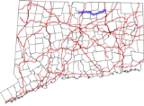
Connecticut Route 140
Encyclopedia
Route 140 is a state highway in Connecticut
in the northeastern part of the Greater Hartford
area. Route 140 is a main artery connecting the town of Ellington
to Hartford
.
. It then begins an overlap with Route 159, before reaching a bridge, and turning away from Route 159. Now known as Bridge Street, it crosses the Connecticut River
into East Windsor
, then meets an intersection with I-91
. Shortly thereafter, it meets an intersection with US 5, before changing its street name to North Road. It then becomes Sadd's Mill Road. It meets an intersection with Route 286
, before becoming Maple Street. It then meets an overlap with Route 83, before becoming Crystal Lake Road. Route 140 then meets an overlap with Route 30, as it becomes Sandy Beach Road. Route 140 then ends as it reaches Route 190
and Route 30 in Stafford
.
, 140, and 286. In the 1920s, this route was known as State Highway 307. In 1961, with the opening of the Bradley Airport Connector as part of Route 20, Routes 140 and 191 were rerouted to their current locations in Windsor Locks and East Windsor. The following year, Route 140 in Windsor Locks was relocated from Spring Street (old Route 20) to Elm Street (former SR 523). In 1963, Route 140 was extended to its eastern terminus in Stafford, and rerouted slightly north to absorb a connector (Route 140A) between Route 83 and the center of Ellington in the process. In the late 1990s and 2002, the alignment was straightened in several parts of East Windsor and Ellington.
Connecticut
Connecticut is a state in the New England region of the northeastern United States. It is bordered by Rhode Island to the east, Massachusetts to the north, and the state of New York to the west and the south .Connecticut is named for the Connecticut River, the major U.S. river that approximately...
in the northeastern part of the Greater Hartford
Greater Hartford
Greater Hartford is a region located in the state of Connecticut, centered on the state's capital of Hartford.Hartford's role as a focal point for the American insurance industry is known nationally. The vibrant music and arts scene defines the region's culture...
area. Route 140 is a main artery connecting the town of Ellington
Ellington, Connecticut
Ellington is a town in Tolland County, Connecticut, United States. Ellington was incorporated in May, 1786, from East Windsor. As of the 2000 census, the town population was 12,921...
to Hartford
Hartford, Connecticut
Hartford is the capital of the U.S. state of Connecticut. The seat of Hartford County until Connecticut disbanded county government in 1960, it is the second most populous city on New England's largest river, the Connecticut River. As of the 2010 Census, Hartford's population was 124,775, making...
.
Route description
Route 140 starts out at Route 75, in Windsor LocksWindsor Locks, Connecticut
Windsor Locks is a town located in Hartford County, Connecticut, United States. As of the 2000 census, its population was 12,043. It is the site of Bradley International Airport, which serves the Greater Hartford-Springfield region. It is also the site of the New England Air Museum...
. It then begins an overlap with Route 159, before reaching a bridge, and turning away from Route 159. Now known as Bridge Street, it crosses the Connecticut River
Connecticut River
The Connecticut River is the largest and longest river in New England, and also an American Heritage River. It flows roughly south, starting from the Fourth Connecticut Lake in New Hampshire. After flowing through the remaining Connecticut Lakes and Lake Francis, it defines the border between the...
into East Windsor
East Windsor, Connecticut
East Windsor is a town in Hartford County, Connecticut, United States. The population was 11,162 at the 2010 census.The town has five villages: Broad Brook, Melrose, Scantic, Warehouse Point and Windsorville.-Area:...
, then meets an intersection with I-91
Interstate 91
Interstate 91 is an Interstate Highway in the New England region of the United States. It provides the primary north–south thoroughfare in the western part of New England...
. Shortly thereafter, it meets an intersection with US 5, before changing its street name to North Road. It then becomes Sadd's Mill Road. It meets an intersection with Route 286
Connecticut Route 286
Route 286 is a minor state highway in northern Connecticut running entirely within the town of Ellington. It serves the community of Windermere Village.-Route description:...
, before becoming Maple Street. It then meets an overlap with Route 83, before becoming Crystal Lake Road. Route 140 then meets an overlap with Route 30, as it becomes Sandy Beach Road. Route 140 then ends as it reaches Route 190
Connecticut Route 190
Route 190 is a state route in the northern part of the U.S. state of Connecticut. It starts at Route 75 in the town of Suffield and proceeds eastward across the Connecticut River through the towns of Enfield, Somers, and Stafford. It ends at Route 171, in the town of Union. Route 190 was...
and Route 30 in Stafford
Stafford, Connecticut
Stafford is a town in Tolland County, Connecticut, United States, settled in 1719. The population was 11,307 at the 2000 census.-History:The Colonial Town of Stafford began as a rural agricultural community...
.
History
Route 140 was commissioned in 1932, running from US 5 to Route 83 along the current routes of Routes 191Connecticut Route 191
Route 191 is a state highway in northern Connecticut, running from East Windsor to Enfield.-Route description:Route 191 begins as Phelps Road at an intersection with US 5 in the town of East Windsor. It heads east through the village of Scantic, turning onto Scantic Road...
, 140, and 286. In the 1920s, this route was known as State Highway 307. In 1961, with the opening of the Bradley Airport Connector as part of Route 20, Routes 140 and 191 were rerouted to their current locations in Windsor Locks and East Windsor. The following year, Route 140 in Windsor Locks was relocated from Spring Street (old Route 20) to Elm Street (former SR 523). In 1963, Route 140 was extended to its eastern terminus in Stafford, and rerouted slightly north to absorb a connector (Route 140A) between Route 83 and the center of Ellington in the process. In the late 1990s and 2002, the alignment was straightened in several parts of East Windsor and Ellington.