
Connecticut Route 82
Encyclopedia
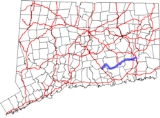
Route 82 is an east–west state highway
in Connecticut
running for 28.47 miles (45.8 km) from Route 9
in Chester
to Route 2
and 32
in Norwich
.
. In Haddam, it continues northeast to an overlap with Route 154
, briefly turning northwest until the two routes separate. From the end of the overlap, Route 82 heads east to the East Haddam Bridge
over the Connecticut River
, entering East Haddam
near Goodspeed Opera House. In East Haddam, Route 82 continues east and southeast to Lyme
. In Lyme, it curves southeast and then northeast to reenter East Haddam, where it continues generally east to Salem
. In Salem, Route 82 continues northeast, meeting the south end of Route 11, and then crossing into Montville
. It then continues east through northern Montville, briefly overlapping Route 163
, and southern Bozrah
, before entering Norwich. In Norwich, it intersects I-395
before ending at a triangular one-way couplet in downtown Norwich, intersecting Routes 2 and 32 over two bridges across the Yantic River
.
 Route 82 is a designated scenic road for the length of the East Haddam Bridge between Haddam and East Haddam.
, old Highway 153 was renumbered to Route 82. The only major changes since then are the extension along a new limited access road west of Route 154 to a trumpet intersection with Route 9 in 1971, and a reorganization of the east terminus in Norwich in the late 1980s.
State highway
State highway, state road or state route can refer to one of three related concepts, two of them related to a state or provincial government in a country that is divided into states or provinces :#A...
in Connecticut
Connecticut
Connecticut is a state in the New England region of the northeastern United States. It is bordered by Rhode Island to the east, Massachusetts to the north, and the state of New York to the west and the south .Connecticut is named for the Connecticut River, the major U.S. river that approximately...
running for 28.47 miles (45.8 km) from Route 9
Route 9 (Connecticut)
Route 9 is a , 4-lane freeway beginning in Old Saybrook and ending at the Farmington-West Hartford town line.-Route description:Route 9 begins at an interchange with I-95/U.S. 1, on the west banks of the Connecticut River...
in Chester
Chester, Connecticut
Chester is a town in Middlesex County, Connecticut, United States. The population was 3,743 at the 2000 census. The town center is also defined by the U.S. Census Bureau as a census-designated place .-Geography:...
to Route 2
Route 2 (Connecticut)
Route 2 is a state highway in Connecticut and is in length. It is a primary state route, with a freeway section connecting Hartford to Norwich and a non-freeway section extending to Stonington.-Route description:...
and 32
Route 32 (Connecticut)
Route 32 is a primary north–south state highway in the U.S. state of Connecticut, beginning in New London and continuing via Willimantic to the Massachusetts state line, where it continues as Route 32 in that state.-Route description:...
in Norwich
Norwich, Connecticut
Regular steamship service between New York and Boston helped Norwich to prosper as a shipping center through the early part of the 20th century. During the Civil War, Norwich once again rallied and saw the growth of its textile, armaments, and specialty item manufacturing...
.
Route description
Route 82 begins at a trumpet intersection with Route 9 in Chester and heads northeast into HaddamHaddam, Connecticut
Haddam is a town in Middlesex County, Connecticut, United States. The population was 7,157 at the 2000 census. The town was also home to the now decommissioned Connecticut Yankee Nuclear Reactor.-Geography:...
. In Haddam, it continues northeast to an overlap with Route 154
Connecticut Route 154
Route 154 is a state highway in Connecticut running for . It serves as one of the main thoroughfares in the town of Old Saybrook, intersecting twice with U.S. Route 1. North of I-95, Route 154 runs parallel to Route 9, along to the west bank of the Connecticut River. The route ends in Middletown...
, briefly turning northwest until the two routes separate. From the end of the overlap, Route 82 heads east to the East Haddam Bridge
East Haddam Bridge
The East Haddam Bridge is a steel, movable truss bridge composed of two main spans crossing the Connecticut River between Haddam, Connecticut and East Haddam, Connecticut. The bridge carries Route 82, with an average daily traffic of 11,600....
over the Connecticut River
Connecticut River
The Connecticut River is the largest and longest river in New England, and also an American Heritage River. It flows roughly south, starting from the Fourth Connecticut Lake in New Hampshire. After flowing through the remaining Connecticut Lakes and Lake Francis, it defines the border between the...
, entering East Haddam
East Haddam, Connecticut
East Haddam is a town in Middlesex County, Connecticut, United States. The population was 8,333 at the 2000 census.-Geography:According to the United States Census Bureau, the town has a total area of , of which, of it is land and of it is water....
near Goodspeed Opera House. In East Haddam, Route 82 continues east and southeast to Lyme
Lyme, Connecticut
Lyme is a town in New London County, Connecticut, United States. The population was 2,016 at the 2000 census. Lyme and its neighboring town Old Lyme are the namesake for Lyme disease.-Geography:...
. In Lyme, it curves southeast and then northeast to reenter East Haddam, where it continues generally east to Salem
Salem, Connecticut
Salem is a town in New London County, Connecticut, United States. The population was 3,858 at the 2000 census.- Pre-incorporation :The area was originally inhabited by Mohegans. The very first settlement of European origin in present-day Salem was deeded in 1664. In the early 18th century, more...
. In Salem, Route 82 continues northeast, meeting the south end of Route 11, and then crossing into Montville
Montville, Connecticut
Montville is a town in New London County, Connecticut, United States. The population was 18,546 at the 2000 census and 19,571 at the 2010 census....
. It then continues east through northern Montville, briefly overlapping Route 163
Connecticut Route 163
Route 163 is a state highway in southeastern Connecticut running from Montville to Bozrah.-Route description:Route 163 begins as Okadale Road at an intersection with Route 32 in the village of Uncasville within the town of Montville. It heads in a northwest direction and soon intersects I-395 ...
, and southern Bozrah
Bozrah, Connecticut
Bozrah is a town in New London County, Connecticut, United States. The population was 2,357 at the 2000 census. Bozrah contains three villages: Fitchville, the town center; Leffingwell, a crossroads on Route 82; and Gilman, a mill village along Fitchville Road....
, before entering Norwich. In Norwich, it intersects I-395
Interstate 395
Interstate 395 may refer to:*Interstate 395 , a spur from I-95 to Washington, D.C.*Interstate 395 , a spur from I-95 to Auburn, Massachusetts*Interstate 395 , a spur in Miami, Florida...
before ending at a triangular one-way couplet in downtown Norwich, intersecting Routes 2 and 32 over two bridges across the Yantic River
Yantic River
The Yantic River forms at the confluence of the Deep River, Sherman Brook, and Exeter Brook about east of Colchester, Connecticut. It runs for and flows into the Shetucket River in Norwich, forming the Thames River...
.
Special Designations
History
Modern Route 82 east of Route 85 was built along the alignment of an early toll road known as the Salem and Norwich Turnpike, which was chartered in 1827 to connect its namesake cities. The toll road was extended west to the village of Hadlyme in 1834 by another turnpike corporation, which built the Hadlyme and Salem Turnpike. The road between East Haddam and Norwich, incorporating both turnpike alignments, was designated in 1922 as State Highway 153. In the 1932 state highway renumbering1932 state highway renumbering (Connecticut)
In 1932, the Highway Department of the U.S. state of Connecticut , decided to completely renumber all its state highways. The only exceptions were the U.S. Highways and some of the New England Interstate Routes. Between 1922 and 1932, Connecticut used a state highway numbering system shared with...
, old Highway 153 was renumbered to Route 82. The only major changes since then are the extension along a new limited access road west of Route 154 to a trumpet intersection with Route 9 in 1971, and a reorganization of the east terminus in Norwich in the late 1980s.
Junction list
| Town | Road names | Major junctions | Milepost |
|---|---|---|---|
| Chester Chester, Connecticut Chester is a town in Middlesex County, Connecticut, United States. The population was 3,743 at the 2000 census. The town center is also defined by the U.S. Census Bureau as a census-designated place .-Geography:... (0.85 miles) |
Route 82 | 0.00-0.64 | |
| Haddam Haddam, Connecticut Haddam is a town in Middlesex County, Connecticut, United States. The population was 7,157 at the 2000 census. The town was also home to the now decommissioned Connecticut Yankee Nuclear Reactor.-Geography:... (2.93 miles) |
Route 82, Bridge Road | (Begin Multiplex) | 2.75 |
| (End Multiplex) | 3.12 | ||
| East Haddam East Haddam, Connecticut East Haddam is a town in Middlesex County, Connecticut, United States. The population was 8,333 at the 2000 census.-Geography:According to the United States Census Bureau, the town has a total area of , of which, of it is land and of it is water.... (5.16 miles) |
Norwich Road, Town Street | 3.99 | |
| 5.34 | |||
| Lyme Lyme, Connecticut Lyme is a town in New London County, Connecticut, United States. The population was 2,016 at the 2000 census. Lyme and its neighboring town Old Lyme are the namesake for Lyme disease.-Geography:... (2.40 miles) |
Town Street, Norwich Salem Rd. | 9.26 | |
| E. Haddam East Haddam, Connecticut East Haddam is a town in Middlesex County, Connecticut, United States. The population was 8,333 at the 2000 census.-Geography:According to the United States Census Bureau, the town has a total area of , of which, of it is land and of it is water.... (3.36 miles) |
Norwich Salem Road | 12.53 | |
| Salem Salem, Connecticut Salem is a town in New London County, Connecticut, United States. The population was 3,858 at the 2000 census.- Pre-incorporation :The area was originally inhabited by Mohegans. The very first settlement of European origin in present-day Salem was deeded in 1664. In the early 18th century, more... (5.84 miles) |
East Haddam Road, Norwich Road | 16.34-16.56 | |
| 17.55-17.56 | |||
| 20.20-20.21 | |||
| Montville Montville, Connecticut Montville is a town in New London County, Connecticut, United States. The population was 18,546 at the 2000 census and 19,571 at the 2010 census.... (3.76 miles) |
Norwich Salem Turnpike | (Begin Multiplex) | 21.31 |
| (End Multiplex) | 21.43 | ||
| Bozrah Bozrah, Connecticut Bozrah is a town in New London County, Connecticut, United States. The population was 2,357 at the 2000 census. Bozrah contains three villages: Fitchville, the town center; Leffingwell, a crossroads on Route 82; and Gilman, a mill village along Fitchville Road.... (1.02 miles) |
Salem Turnpike | (No Major Junctions) | |
| Norwich Norwich, Connecticut Regular steamship service between New York and Boston helped Norwich to prosper as a shipping center through the early part of the 20th century. During the Civil War, Norwich once again rallied and saw the growth of its textile, armaments, and specialty item manufacturing... (3.15 miles) |
Salem Turnpike, Westside Boulevard | 26.22-26.39 | |
| (Begin Westside Boulevard one-way couplet) | 28.20 | ||
| 28.29 | |||
| 28.47 |