

Effects of Hurricane Ivan in the Lesser Antilles and South America
Encyclopedia
The effects of Hurricane Ivan in the Lesser Antilles and South America included 44 deaths and over $1 billion in damage (2004 USD), primarily in Grenada
where it was considered the worst hurricane in nearly 50 years. Hurricane Ivan
developed from a tropical wave
on September 2 and rapidly intensified to become a major hurricane, passing through the southern Lesser Antilles
on September 7 with winds of 125 mph (205 km/h). At the time, its tropical storm force winds extended outward up to 160 miles (260 km) with hurricane force winds outward to 70 miles (110 km), and the northern portion of the eye
passed over Grenada.
In the region, the worst damage occurred on Grenada, where the damage total of $1.1 billion (2004 USD, ($ USD) represented 200% of its GDP
. The hurricane damaged more than 14,000 homes in the nation, and 30% of the houses in the nation were destroyed which left about 18,000 people homeless. A total of 39 people were killed by the hurricane on the island. Elsewhere, moderate damage was reported in northern Venezuela
, where at least three fatalities were reported. One person died each in Trinidad
and Barbados
. The name Ivan was later retired.
consistently forecast Ivan to track further to the north than it eventually did. Late on September 5, the government of Barbados issued a hurricane watch
for its territory. Shortly thereafter, Saint Lucia
was put under a hurricane watch and Grenada and its dependencies were put under a tropical storm watch. As the hurricane approached the southern Lesser Antilles, more watches were issued, and by 24 hours prior to Ivan passing through the island chain a hurricane warning was in effect for Barbados, Saint Vincent and the Grenadines, Saint Lucia, Tobago
, and Grenada, and a tropical storm warning was in effect for Trinidad. With the path of Ivan more southerly than predicted, the hurricane warnings were downgraded to tropical storm warnings for the northern islands, and by late on September 7 when the eye of the hurricane passed near Grenada, hurricane warnings were in effect for Saint Vincent and the Grenadines, Trinidad and Tobago, and Grenada. Subsequently, a tropical storm warning was issued for the northern coast of Venezuela through the Guajira Peninsula
of Colombia
.
On Venezuela, citizens in coastal areas of Sucre
and Isla Margarita
were moved to safer areas, and several thousands were evacuated due to the hurricane. The Simón Bolívar International Airport
, as well as three other mainland airports, were closed. Petróleos de Venezuela S.A.
temporarily closed its oil refinery in Curaçao
, and two ports were briefly shut down; this caused a delay in two oil deliveries. The Valero Energy Corporation shut down its largest oil refinery in Aruba
. Prior to the arrival of the hurricane, oil companies in Trinidad and Tobago
ceased production and removed workers from offshore rigs; the Atlantic LNG
company closed exports. Seven shelters were opened on Tobago, where about 560 people evacuated for the storm. Most evacuees were from low-lying areas, and on the day of the storm's passage most schools and businesses were closed. The two main airports in the country were closed, with one airline canceling all of its flights.
Over 1,000 people evacuated to emergency shelters on Grenada, including hundreds in low-lying areas in the capital city. Some shelters were damaged during the hurricane, forcing the evacuees to go elsewhere. Overall, the population responded little to the official advisories and recommendations, which potentially contributed to the death toll on the island. More than 1,000 residents of Saint Vincent and the Grenadines evacuated to 28 emergency shelters. On Barbados, officials closed schools and government buildings and prepared shelters prior to the arrival of the hurricane. To minimize danger, the island power grid was shut down. Four shelters opened on Saint Lucia, where many people sought safety during the storm.
of about 13 feet (4 m), which damaged 60 homes. Sustained winds on Isla Margarita peaked at 26 mph (42 km/h), and the most affected states were Vargas
, Aragua
, Carabobo
, and Anzoátegui
. Rough waves capsized 10 boats and closed several beaches, and one person drowned due to the surf. Further inland, two people drowned due to an overflown river, and near Caracas
a man died after strong winds toppled a wall. The combination of rainfall and winds destroyed 21 houses and blew off the roof of several others, affecting 1,376 people, of which 80 were left homeless. Power outages and lack of water were reported. In the country, the hurricane caused 127 injuries, and a death toll reported between three and five. An initial news story reported 28 people missing offshore on three boats.
Moderate wind gusts of up 46 mph (74 km/h) were reported in Tobago, which downed several trees and caused power outages in seven villages; power was cut to more than 30% of the island. Twenty villages on the island suffered various forms of damage, and at least 45 homes lost their roofs. The hurricane left 22 people homeless and directly impacted about 1,000 people. The hurricane caused one death when a falling tree killed a woman. Wave heights were estimated at 65 feet (20 m), and at least one home collapsed and fell into the ocean. Rainfall from the storm's passage unofficially peaked at 16.2 inches (411 mm) on the island, which caused some mudslides. Some crop damage was also reported, and overall damage on Tobago was estimated at $4.9 million (2004 USD, ($ USD); damage in neighboring Trinidad was minimal.
As Ivan continued to strengthen, it proceeded about 80 mi (130 km) north of the ABC Islands on September 9. High winds blew away roof shingles and produced large swell
s that battered several coastal facilities. A developing spiral band
dropped heavy rainfall over Aruba
, causing flooding and $1.1 million worth in structural damage.
 Passing just to the south of the island, Hurricane Ivan produced strong winds in Grenada, with sustained winds reaching 120 mph (195 km/h) and gusts peaking at 133 mph (215 km/h) at Point Salines International Airport
. The airport recorded 5.26 inches (134 mm) of precipitation during the hurricane's passage. Of the nation's six parishes
, the four southernmost ones were most severely affected, constituting 80 percent of the total population.
The strong winds impacted more than 14,000 homes on Grenada with 90 percent of the nation's houses damaged and of which 30 percent were destroyed. The capital city of St. George's
was severely damaged, where every major building was either damaged or destroyed. Ivan's passage either damaged or destroyed 85 percent of the structures on the island, including the nation's emergency operations center and a 17th century prison, which allowed many inmates to briefly escape during the height of the storm. The hurricane damaged or destroyed 75 primary or secondary schools, with only two left in working condition. All of Grenada was left without power or running water.
Tourism was adversely affected; an estimated 60 percent of hotel rooms were damaged. The winds downed 80 percent of the nutmeg
trees on the island, with other crop losses varying between 60–90 percent. An estimated 18,000 people were left homeless by the hurricane, and about 700 people sustained injuries from the storm. Ivan was considered the worst hurricane to strike the nation since Hurricane Janet
in 1955
; its passage resulted in 39 fatalities and $1.1 billion in damage (2004 USD, ($ USD), about 200% of its GDP
and of which about 45% resulted from housing damage.
, which washed away 2 homes; the storm surge destroyed 19 homes and damaged 40 more. On Union Island
, the winds damaged the roof of a hospital, while the northern portion of the island sustained heavy damage from the waves. Moderate damage was also reported on Palm Island
and Carriacou and Petite Martinique
. The winds left more than two-thirds of the island without power, and also damaged the island's banana crop. Damage in the country totaled $40 million (2004 USD, ($ USD).
On the island of Barbados, sustained winds peaked at 69 mph (112 km/h) while gusts reached 92 mph (149 km/h), which damaged many trees and roofs. A total of 531 houses were damaged, of which 43 were completely destroyed. Additionally, four hotels sustained some damage. The winds left most of island left without electricity, though officials worked quickly to restore the power. Rainfall from the storm was light, remaining less than 1 inch (25 mm) in most areas. Storm surge and wave action caused beach erosion that severely damaged most coastal roads. One death was reported on the island, and damage was estimated at more than $5 million (2004 USD, ($ USD).
Strong winds and rough surf caused moderate coastal damage to southern portions of Saint Lucia; the combination impacted houses near the coast and also led to losses in the banana crop. Minor roof damage was also reported, and damage totalled $2.6 million (2004 USD $ USD)) on the island; three serious injuries were reported on the island due to the hurricane, though no fatalities were reported. In Dominica
, winds reached 43 mph (69 km/h). High waves from Ivan caused light damage to southwestern Martinique
and Guadeloupe
.
 Several nearby countries assisted Grenada in its aftermath. The government of Guyana
shipped about $250,000 (2004 USD, $40 million 2004 GYD) worth of sugar, as well as 100 members of the Guyana Defense Force to assist in restoring order and reconstruction. The government of Trinidad & Tobago sent 190 policemen, and the government of Anguilla
sent 1,230 cases of water. A committee of Caribbean nations realized the local governments could not provide the support that Grenada needed in its aftermath, and thus turned to international assistance. Within a day of Ivan passing to the south of Grenada, the United States Agency for International Development
(USAID) deployed 67,600 gallons of water, 500 rolls of plastic sheeting, four 10,000 liter water bladder kits, and a water treatment kit; assistance from USAID totaled $6 million (2004 USD) within a few weeks of the storm's passage, primarily in aid for reconstruction and rehabilitation. In the weeks subsequent to the hurricane, the European Commission Humanitarian aid Office
(ECHO) provided €3 million (2004 EUR
). By a year later, housing redevelopments and disaster preparation problems continued after being impacted by Hurricane Emily
; as a result, the ECHO provided €1.2 million (2005 EUR) to Grenada in September 2005. Nine months after the hurricane, Chinese officials provided assistance in reconstruction and handling foreign debts after meeting with the Grenadian Prime Minister; in 2007, Chinese officials funded the construction of a new $40 million (2007 USD) cricket stadium near St. George's. The Caribbean Development Bank
approved a $10 million loan (2004 USD) requested by the government of Grenada in July 2005, which was intended to assist in long-term development of the housing, business, and environmental sectors. Emergency operations in Grenada in coordination with the Pan American Disaster Response Unit
ended in July 2005.
Within a few days after the hurricane passed, the Grenada Emergency Operations Center temporarily prevented relief supplies from entering the country to ensure the safety of the incoming items; the decision was reversed shortly thereafter, and planes flew supplies during daylight hours into the reopened airport. Severe looting occurred in the immediate aftermath of Ivan, prompting police officials to enact a curfew for the night hours. In the first week following the hurricane, aid was slow to the affected residents, due to the lack of an efficient aid distribution system. 30 official shelters and 17 prepared ones housed over 5,000 people in the aftermath of the storm. Thousands of people lost their jobs due to the hurricane, with all businesses shut down following the hurricane. By two months after the hurricane struck, 65 schools were opened, some of which serving as shelters; water and power were gradually restored to the island. By a year after the storm's passage, all schools were reopened, and most buildings enacted provisional repairs. Officials determined around 10,000 houses on the island required complete reconstruction, while a further 22,000 needed repairs. The government of Grenada initially planned to rebuild 1,000 houses in the year after the hurricane struck; by June 2005, 260 families were provided houses, with a further 85 under construction. The government also established a Material Assistance Programme, which provided $5,000 (2004 XCD
) of free materials to more than 5,000 families, as well as a total of $4.3 million (2004 XCD) in low interest loans to 148 families. Several indirect fatalities occurred in the aftermath of the hurricane, primarily senior citizens.
Grenada
Grenada is an island country and Commonwealth Realm consisting of the island of Grenada and six smaller islands at the southern end of the Grenadines in the southeastern Caribbean Sea...
where it was considered the worst hurricane in nearly 50 years. Hurricane Ivan
Hurricane Ivan
Hurricane Ivan was a large, long-lived, Cape Verde-type hurricane that caused widespread damage in the Caribbean and United States. The cyclone was the ninth named storm, the sixth hurricane and the fourth major hurricane of the active 2004 Atlantic hurricane season...
developed from a tropical wave
Tropical wave
Tropical waves, easterly waves, or tropical easterly waves, also known as African easterly waves in the Atlantic region, are a type of atmospheric trough, an elongated area of relatively low air pressure, oriented north to south, which move from east to west across the tropics causing areas of...
on September 2 and rapidly intensified to become a major hurricane, passing through the southern Lesser Antilles
Lesser Antilles
The Lesser Antilles are a long, partly volcanic island arc in the Western Hemisphere. Most of its islands form the eastern boundary of the Caribbean Sea with the Atlantic Ocean, with the remainder located in the southern Caribbean just north of South America...
on September 7 with winds of 125 mph (205 km/h). At the time, its tropical storm force winds extended outward up to 160 miles (260 km) with hurricane force winds outward to 70 miles (110 km), and the northern portion of the eye
Eye (cyclone)
The eye is a region of mostly calm weather found at the center of strong tropical cyclones. The eye of a storm is a roughly circular area and typically 30–65 km in diameter. It is surrounded by the eyewall, a ring of towering thunderstorms where the second most severe weather of a cyclone...
passed over Grenada.
In the region, the worst damage occurred on Grenada, where the damage total of $1.1 billion (2004 USD, ($ USD) represented 200% of its GDP
Gross domestic product
Gross domestic product refers to the market value of all final goods and services produced within a country in a given period. GDP per capita is often considered an indicator of a country's standard of living....
. The hurricane damaged more than 14,000 homes in the nation, and 30% of the houses in the nation were destroyed which left about 18,000 people homeless. A total of 39 people were killed by the hurricane on the island. Elsewhere, moderate damage was reported in northern Venezuela
Venezuela
Venezuela , officially called the Bolivarian Republic of Venezuela , is a tropical country on the northern coast of South America. It borders Colombia to the west, Guyana to the east, and Brazil to the south...
, where at least three fatalities were reported. One person died each in Trinidad
Trinidad
Trinidad is the larger and more populous of the two major islands and numerous landforms which make up the island nation of Trinidad and Tobago. It is the southernmost island in the Caribbean and lies just off the northeastern coast of Venezuela. With an area of it is also the fifth largest in...
and Barbados
Barbados
Barbados is an island country in the Lesser Antilles. It is in length and as much as in width, amounting to . It is situated in the western area of the North Atlantic and 100 kilometres east of the Windward Islands and the Caribbean Sea; therein, it is about east of the islands of Saint...
. The name Ivan was later retired.
Preparations
Early in the duration of the storm, the National Hurricane CenterNational Hurricane Center
The National Hurricane Center , located at Florida International University in Miami, Florida, is the division of the National Weather Service responsible for tracking and predicting weather systems within the tropics between the Prime Meridian and the 140th meridian west poleward to the 30th...
consistently forecast Ivan to track further to the north than it eventually did. Late on September 5, the government of Barbados issued a hurricane watch
Tropical cyclone warnings and watches
Warnings and watches are two levels of alert issued by national weather forecasting bodies to coastal areas threatened by the imminent approach of a tropical cyclone of tropical storm or hurricane intensity. They are notices to the local population and civil authorities to make appropriate...
for its territory. Shortly thereafter, Saint Lucia
Saint Lucia
Saint Lucia is an island country in the eastern Caribbean Sea on the boundary with the Atlantic Ocean. Part of the Lesser Antilles, it is located north/northeast of the island of Saint Vincent, northwest of Barbados and south of Martinique. It covers a land area of 620 km2 and has an...
was put under a hurricane watch and Grenada and its dependencies were put under a tropical storm watch. As the hurricane approached the southern Lesser Antilles, more watches were issued, and by 24 hours prior to Ivan passing through the island chain a hurricane warning was in effect for Barbados, Saint Vincent and the Grenadines, Saint Lucia, Tobago
Tobago
Tobago is the smaller of the two main islands that make up the Republic of Trinidad and Tobago. It is located in the southern Caribbean, northeast of the island of Trinidad and southeast of Grenada. The island lies outside the hurricane belt...
, and Grenada, and a tropical storm warning was in effect for Trinidad. With the path of Ivan more southerly than predicted, the hurricane warnings were downgraded to tropical storm warnings for the northern islands, and by late on September 7 when the eye of the hurricane passed near Grenada, hurricane warnings were in effect for Saint Vincent and the Grenadines, Trinidad and Tobago, and Grenada. Subsequently, a tropical storm warning was issued for the northern coast of Venezuela through the Guajira Peninsula
Guajira Peninsula
Guajira Peninsula , is a peninsula in northern Colombia and northwestern Venezuela in the Caribbean Sea...
of Colombia
Colombia
Colombia, officially the Republic of Colombia , is a unitary constitutional republic comprising thirty-two departments. The country is located in northwestern South America, bordered to the east by Venezuela and Brazil; to the south by Ecuador and Peru; to the north by the Caribbean Sea; to the...
.
On Venezuela, citizens in coastal areas of Sucre
Sucre (state)
Sucre State is one of the 23 states of Venezuela. The state capital is Cumaná. Sucre State covers a total surface area of 11,800 km² and, in 2007, had an estimated population of 916,600.-Municipalities and municipal seats:...
and Isla Margarita
Isla Margarita
Margarita Island is the largest island of the state of Nueva Esparta in Venezuela, situated in the Caribbean Sea, off the northeastern coast of the country. The state also contains two other smaller islands: Coche and Cubagua. The capital city of Nueva Esparta is La Asunción, located in a river...
were moved to safer areas, and several thousands were evacuated due to the hurricane. The Simón Bolívar International Airport
Simón Bolívar International Airport (Venezuela)
Simón Bolívar International Airport of Maiquetia is an international airport located in Maiquetía, Venezuela, about 13 miles from downtown Caracas....
, as well as three other mainland airports, were closed. Petróleos de Venezuela S.A.
Petróleos de Venezuela S.A.
Petróleos de Venezuela, S.A. is the Venezuelan state-owned petroleum company. It has activities in exploration, production, refining and exporting oil, as well as exploration and production of natural gas...
temporarily closed its oil refinery in Curaçao
Curaçao
Curaçao is an island in the southern Caribbean Sea, off the Venezuelan coast. The Country of Curaçao , which includes the main island plus the small, uninhabited island of Klein Curaçao , is a constituent country of the Kingdom of the Netherlands...
, and two ports were briefly shut down; this caused a delay in two oil deliveries. The Valero Energy Corporation shut down its largest oil refinery in Aruba
Aruba
Aruba is a 33 km-long island of the Lesser Antilles in the southern Caribbean Sea, located 27 km north of the coast of Venezuela and 130 km east of Guajira Peninsula...
. Prior to the arrival of the hurricane, oil companies in Trinidad and Tobago
Trinidad and Tobago
Trinidad and Tobago officially the Republic of Trinidad and Tobago is an archipelagic state in the southern Caribbean, lying just off the coast of northeastern Venezuela and south of Grenada in the Lesser Antilles...
ceased production and removed workers from offshore rigs; the Atlantic LNG
Atlantic LNG
The Atlantic LNG Company of Trinidad and Tobago is a liquefied natural gas producing company operating a liquefied natural gas plant in Point Fortin, Trinidad and Tobago. Atlantic LNG operates four liquefaction units...
company closed exports. Seven shelters were opened on Tobago, where about 560 people evacuated for the storm. Most evacuees were from low-lying areas, and on the day of the storm's passage most schools and businesses were closed. The two main airports in the country were closed, with one airline canceling all of its flights.
Over 1,000 people evacuated to emergency shelters on Grenada, including hundreds in low-lying areas in the capital city. Some shelters were damaged during the hurricane, forcing the evacuees to go elsewhere. Overall, the population responded little to the official advisories and recommendations, which potentially contributed to the death toll on the island. More than 1,000 residents of Saint Vincent and the Grenadines evacuated to 28 emergency shelters. On Barbados, officials closed schools and government buildings and prepared shelters prior to the arrival of the hurricane. To minimize danger, the island power grid was shut down. Four shelters opened on Saint Lucia, where many people sought safety during the storm.
Venezuela, Trinidad and Tobago, and the ABC Islands
Along the northern coastline of Venezuela, the hurricane produced heavy precipitation and a storm surgeStorm surge
A storm surge is an offshore rise of water associated with a low pressure weather system, typically tropical cyclones and strong extratropical cyclones. Storm surges are caused primarily by high winds pushing on the ocean's surface. The wind causes the water to pile up higher than the ordinary sea...
of about 13 feet (4 m), which damaged 60 homes. Sustained winds on Isla Margarita peaked at 26 mph (42 km/h), and the most affected states were Vargas
Vargas (state)
Vargas State is one of the 23 states of Venezuela. Named after Venezuela's first non-military president, José María Vargas, Vargas comprises a coastal region in the north of Venezuela, bordering Aragua to the west, Miranda to the east, the Caribbean Sea to the north and the Capital District to the...
, Aragua
Aragua (state)
Aragua State is located in the north-central region of Venezuela. It has plains and jungles and Caribbean beaches. The most popular are Cata and Choroni...
, Carabobo
Carabobo
Carabobo State is one of the 23 states of Venezuela, located in the north of the country, about two hours by car from Caracas. The capital city of this state is Valencia, which is also the country's main industrial center. The state's area is 4,650 km² and had an estimated population of...
, and Anzoátegui
Anzoátegui
Anzoátegui State , is one of the 23 component states of Venezuela, located in the northeastern region of the country. Anzoátegui is well known for its beautiful beaches that attract many visitors. Its coast consists of a single beach approximately 100 km long...
. Rough waves capsized 10 boats and closed several beaches, and one person drowned due to the surf. Further inland, two people drowned due to an overflown river, and near Caracas
Caracas
Caracas , officially Santiago de León de Caracas, is the capital and largest city of Venezuela; natives or residents are known as Caraquenians in English . It is located in the northern part of the country, following the contours of the narrow Caracas Valley on the Venezuelan coastal mountain range...
a man died after strong winds toppled a wall. The combination of rainfall and winds destroyed 21 houses and blew off the roof of several others, affecting 1,376 people, of which 80 were left homeless. Power outages and lack of water were reported. In the country, the hurricane caused 127 injuries, and a death toll reported between three and five. An initial news story reported 28 people missing offshore on three boats.
Moderate wind gusts of up 46 mph (74 km/h) were reported in Tobago, which downed several trees and caused power outages in seven villages; power was cut to more than 30% of the island. Twenty villages on the island suffered various forms of damage, and at least 45 homes lost their roofs. The hurricane left 22 people homeless and directly impacted about 1,000 people. The hurricane caused one death when a falling tree killed a woman. Wave heights were estimated at 65 feet (20 m), and at least one home collapsed and fell into the ocean. Rainfall from the storm's passage unofficially peaked at 16.2 inches (411 mm) on the island, which caused some mudslides. Some crop damage was also reported, and overall damage on Tobago was estimated at $4.9 million (2004 USD, ($ USD); damage in neighboring Trinidad was minimal.
As Ivan continued to strengthen, it proceeded about 80 mi (130 km) north of the ABC Islands on September 9. High winds blew away roof shingles and produced large swell
Swell
Swell may refer to:*Swell , a formation of long wavelength ocean surface waves*Swell , an indie rock band from San Francisco*Swell, Gloucestershire, England*Swell , a term in bookbinding...
s that battered several coastal facilities. A developing spiral band
Rainband
A rainband is a cloud and precipitation structure associated with an area of rainfall which is significantly elongated. Rainbands can be stratiform or convective, and are generated by differences in temperature. When noted on weather radar imagery, this precipitation elongation is referred to as...
dropped heavy rainfall over Aruba
Aruba
Aruba is a 33 km-long island of the Lesser Antilles in the southern Caribbean Sea, located 27 km north of the coast of Venezuela and 130 km east of Guajira Peninsula...
, causing flooding and $1.1 million worth in structural damage.
Grenada
Point Salines International Airport
Maurice Bishop International Airport , formerly known as Point Salines International Airport, is located in the parish of St. George's. The town of St. George's is about north of the airport and is the capital of the island nation of Grenada...
. The airport recorded 5.26 inches (134 mm) of precipitation during the hurricane's passage. Of the nation's six parishes
Parishes of Grenada
|The Caribbean island country of Grenada is subdivided into sub-regions known as parishes.A parish defines a territorial unit or region that, historically, was usually an area under the pastoral care served by a local church as an ecclesiastical administrative unit and later used by map-makers to...
, the four southernmost ones were most severely affected, constituting 80 percent of the total population.
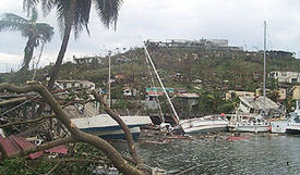
The strong winds impacted more than 14,000 homes on Grenada with 90 percent of the nation's houses damaged and of which 30 percent were destroyed. The capital city of St. George's
St. George's, Grenada
St. George's, population 89,018 , with an agglomeration of 4,500 people , is the capital of Grenada, . The city is surrounded by a hillside of an old volcano crater and is on a horseshoe-shaped harbor....
was severely damaged, where every major building was either damaged or destroyed. Ivan's passage either damaged or destroyed 85 percent of the structures on the island, including the nation's emergency operations center and a 17th century prison, which allowed many inmates to briefly escape during the height of the storm. The hurricane damaged or destroyed 75 primary or secondary schools, with only two left in working condition. All of Grenada was left without power or running water.
Tourism was adversely affected; an estimated 60 percent of hotel rooms were damaged. The winds downed 80 percent of the nutmeg
Nutmeg
The nutmeg tree is any of several species of trees in genus Myristica. The most important commercial species is Myristica fragrans, an evergreen tree indigenous to the Banda Islands in the Moluccas of Indonesia...
trees on the island, with other crop losses varying between 60–90 percent. An estimated 18,000 people were left homeless by the hurricane, and about 700 people sustained injuries from the storm. Ivan was considered the worst hurricane to strike the nation since Hurricane Janet
Hurricane Janet
Hurricane Janet was the most powerful hurricane of the 1955 Atlantic hurricane season and one of the strongest Atlantic hurricanes on record. It made landfall as a Category 5 hurricane on the Saffir-Simpson Hurricane Scale, causing catastrophic damage and at least 687 deaths in the Lesser...
in 1955
1955 Atlantic hurricane season
The 1955 Atlantic hurricane season officially began on June 15, 1955, and lasted until November 15, 1955. These dates conventionally delimit the period of each year when most tropical cyclones form in the Atlantic basin. The 1955 season was active, with twelve tropical storms forming.Three...
; its passage resulted in 39 fatalities and $1.1 billion in damage (2004 USD, ($ USD), about 200% of its GDP
Gross domestic product
Gross domestic product refers to the market value of all final goods and services produced within a country in a given period. GDP per capita is often considered an indicator of a country's standard of living....
and of which about 45% resulted from housing damage.
Saint Vincent and the Grenadines, Barbados, and northward
Wave heights from the hurricane reached 20 feet (6 m) along coastline portions of Saint Vincent and the GrenadinesSaint Vincent and the Grenadines
Saint Vincent and the Grenadines is an island country in the Lesser Antilles chain, namely in the southern portion of the Windward Islands, which lie at the southern end of the eastern border of the Caribbean Sea where the latter meets the Atlantic Ocean....
, which washed away 2 homes; the storm surge destroyed 19 homes and damaged 40 more. On Union Island
Union Island
Union Island is part of the nation of St. Vincent and the Grenadines. It the southernmost island of the Grenadines. It lies 90 kilometers southwest of Barbados and is within view of the islands of Carriacou and the mainland of Grenada, which lie directly south.Clifton and Ashton are the two...
, the winds damaged the roof of a hospital, while the northern portion of the island sustained heavy damage from the waves. Moderate damage was also reported on Palm Island
Palm Island, Grenadines
Palm Island in the Grenadines is a tiny island a mile from Union Island, and only accessible by boat. It has an area of and has five beaches...
and Carriacou and Petite Martinique
Carriacou and Petite Martinique
Carriacou and Petite Martinique is the dependency of Grenada, lying north of Grenada island and south of Saint Vincent and the Grenadines in the Lesser Antilles. The Grenadine islands to the north of Carriacou and Petite Martinique belong to the nation of St...
. The winds left more than two-thirds of the island without power, and also damaged the island's banana crop. Damage in the country totaled $40 million (2004 USD, ($ USD).
On the island of Barbados, sustained winds peaked at 69 mph (112 km/h) while gusts reached 92 mph (149 km/h), which damaged many trees and roofs. A total of 531 houses were damaged, of which 43 were completely destroyed. Additionally, four hotels sustained some damage. The winds left most of island left without electricity, though officials worked quickly to restore the power. Rainfall from the storm was light, remaining less than 1 inch (25 mm) in most areas. Storm surge and wave action caused beach erosion that severely damaged most coastal roads. One death was reported on the island, and damage was estimated at more than $5 million (2004 USD, ($ USD).
Strong winds and rough surf caused moderate coastal damage to southern portions of Saint Lucia; the combination impacted houses near the coast and also led to losses in the banana crop. Minor roof damage was also reported, and damage totalled $2.6 million (2004 USD $ USD)) on the island; three serious injuries were reported on the island due to the hurricane, though no fatalities were reported. In Dominica
Dominica
Dominica , officially the Commonwealth of Dominica, is an island nation in the Lesser Antilles region of the Caribbean Sea, south-southeast of Guadeloupe and northwest of Martinique. Its size is and the highest point in the country is Morne Diablotins, which has an elevation of . The Commonwealth...
, winds reached 43 mph (69 km/h). High waves from Ivan caused light damage to southwestern Martinique
Martinique
Martinique is an island in the eastern Caribbean Sea, with a land area of . Like Guadeloupe, it is an overseas region of France, consisting of a single overseas department. To the northwest lies Dominica, to the south St Lucia, and to the southeast Barbados...
and Guadeloupe
Guadeloupe
Guadeloupe is an archipelago located in the Leeward Islands, in the Lesser Antilles, with a land area of 1,628 square kilometres and a population of 400,000. It is the first overseas region of France, consisting of a single overseas department. As with the other overseas departments, Guadeloupe...
.
Aftermath
The government of Barbados created a Hurricane Ivan Housing Recovery Project, which repaired or rebuilt 190 houses for people without the available funds; around 90 homes required minor immediate repairs, while the rest required significant reconstruction. The project finished in early 2006 for a total of $5 million (2004 BBD, ($ USD).Guyana
Guyana , officially the Co-operative Republic of Guyana, previously the colony of British Guiana, is a sovereign state on the northern coast of South America that is culturally part of the Anglophone Caribbean. Guyana was a former colony of the Dutch and of the British...
shipped about $250,000 (2004 USD, $40 million 2004 GYD) worth of sugar, as well as 100 members of the Guyana Defense Force to assist in restoring order and reconstruction. The government of Trinidad & Tobago sent 190 policemen, and the government of Anguilla
Anguilla
Anguilla is a British overseas territory and overseas territory of the European Union in the Caribbean. It is one of the most northerly of the Leeward Islands in the Lesser Antilles, lying east of Puerto Rico and the Virgin Islands and directly north of Saint Martin...
sent 1,230 cases of water. A committee of Caribbean nations realized the local governments could not provide the support that Grenada needed in its aftermath, and thus turned to international assistance. Within a day of Ivan passing to the south of Grenada, the United States Agency for International Development
United States Agency for International Development
The United States Agency for International Development is the United States federal government agency primarily responsible for administering civilian foreign aid. President John F. Kennedy created USAID in 1961 by executive order to implement development assistance programs in the areas...
(USAID) deployed 67,600 gallons of water, 500 rolls of plastic sheeting, four 10,000 liter water bladder kits, and a water treatment kit; assistance from USAID totaled $6 million (2004 USD) within a few weeks of the storm's passage, primarily in aid for reconstruction and rehabilitation. In the weeks subsequent to the hurricane, the European Commission Humanitarian aid Office
ECHO (European Commission)
The Humanitarian Aid department of the European Commission , formerly known as the European Community Humanitarian Aid Office, is the European Commission's department for overseas humanitarian aid...
(ECHO) provided €3 million (2004 EUR
Euro
The euro is the official currency of the eurozone: 17 of the 27 member states of the European Union. It is also the currency used by the Institutions of the European Union. The eurozone consists of Austria, Belgium, Cyprus, Estonia, Finland, France, Germany, Greece, Ireland, Italy, Luxembourg,...
). By a year later, housing redevelopments and disaster preparation problems continued after being impacted by Hurricane Emily
Hurricane Emily (2005)
Hurricane Emily was a powerful, early season tropical cyclone that caused significant damage across the Caribbean Sea to Mexico. A Cape Verde-type hurricane, the storm formed on July 10, 2005, in the central Atlantic Ocean before passing through the Windward Islands on July 14...
; as a result, the ECHO provided €1.2 million (2005 EUR) to Grenada in September 2005. Nine months after the hurricane, Chinese officials provided assistance in reconstruction and handling foreign debts after meeting with the Grenadian Prime Minister; in 2007, Chinese officials funded the construction of a new $40 million (2007 USD) cricket stadium near St. George's. The Caribbean Development Bank
Caribbean Development Bank
The Caribbean Development Bank is a financial institution which assists Caribbean nations in financing social and economic programs in its member countries...
approved a $10 million loan (2004 USD) requested by the government of Grenada in July 2005, which was intended to assist in long-term development of the housing, business, and environmental sectors. Emergency operations in Grenada in coordination with the Pan American Disaster Response Unit
International Federation of Red Cross and Red Crescent Societies
The International Federation of Red Cross and Red Crescent Societies is a humanitarian institution that is part of the International Red Cross and Red Crescent Movement along with the ICRC and 186 distinct National Societies...
ended in July 2005.
Within a few days after the hurricane passed, the Grenada Emergency Operations Center temporarily prevented relief supplies from entering the country to ensure the safety of the incoming items; the decision was reversed shortly thereafter, and planes flew supplies during daylight hours into the reopened airport. Severe looting occurred in the immediate aftermath of Ivan, prompting police officials to enact a curfew for the night hours. In the first week following the hurricane, aid was slow to the affected residents, due to the lack of an efficient aid distribution system. 30 official shelters and 17 prepared ones housed over 5,000 people in the aftermath of the storm. Thousands of people lost their jobs due to the hurricane, with all businesses shut down following the hurricane. By two months after the hurricane struck, 65 schools were opened, some of which serving as shelters; water and power were gradually restored to the island. By a year after the storm's passage, all schools were reopened, and most buildings enacted provisional repairs. Officials determined around 10,000 houses on the island required complete reconstruction, while a further 22,000 needed repairs. The government of Grenada initially planned to rebuild 1,000 houses in the year after the hurricane struck; by June 2005, 260 families were provided houses, with a further 85 under construction. The government also established a Material Assistance Programme, which provided $5,000 (2004 XCD
East Caribbean dollar
The East Caribbean dollar is the currency of eight of the nine members of the Organisation of Eastern Caribbean States...
) of free materials to more than 5,000 families, as well as a total of $4.3 million (2004 XCD) in low interest loans to 148 families. Several indirect fatalities occurred in the aftermath of the hurricane, primarily senior citizens.
See also
- Hurricane IvanHurricane IvanHurricane Ivan was a large, long-lived, Cape Verde-type hurricane that caused widespread damage in the Caribbean and United States. The cyclone was the ninth named storm, the sixth hurricane and the fourth major hurricane of the active 2004 Atlantic hurricane season...
- List of South America tropical cyclones