
.gif)
Tropical Storm Odette (2003)
Encyclopedia
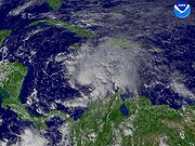
Tropical Storm Odette was a rare off-season tropical storm that affected the Caribbean Sea
in December 2003. The 15th tropical storm of the 2003 Atlantic hurricane season
, Odette formed near the coast of Panama
a few days after the official end of the Atlantic hurricane season
, and ultimately made landfall on the Dominican Republic
as a moderate tropical storm.
The storm caused heavy damage throughout the Dominican Republic from unusually heavy rainfall in December. Preparation preceding Odette's landfall resulted in only eight deaths and 14 injuries. Total damage is unknown, though crop damage in the Dominican Republic totaled to over $8 million (2003 USD, $8.8 million 2006 USD).
extended across eastern Cuba
into the southwestern Caribbean Sea
. On December 1, a low pressure area
developed within the frontal zone just north of Panama
, and an anticyclone
aloft produced good outflow
over the low-level center. The low remained nearly stationary for the next several days, and it gradually became separated from the stationary front. Convection increased across the area due to moisture from the eastern Pacific Ocean
and moderate divergence
. Increased wind shear
deteriorated the system on December 2, though convection redeveloped as the system started a northeast drift. On December 3 a mid-level circulation developed about 140 miles (225 km) north of the surface center. Convection increased and became better organized as a weak tropical wave
reached the area, and it is estimated the system developed into Tropical Depression Twenty at around 1200 UTC
on December 4 while located about 345 miles (560 km) south of Kingston, Jamaica
; initially, the depression was forecast to track north-northeastward and pass over western Haiti
.
Upon being classified as a tropical cyclone, the depression was embedded within the southwesterly flow between a ridge
over the eastern Caribbean Sea and a mid-latitude trough
, which caused a steady east-northeast motion. The convection organized into a central dense overcast with a well-defined cloud band wrapping partially around the center, and based on satellite imagery estimates the depression was upgraded to tropical storm status; late on December 4, the National Hurricane Center
named the storm Odette
. After being named, the storm intensified despite moderate southwesterly wind shear
, and an eye feature
became evident on microwave satellite imagery. Additionally, about three–fourths of a mid-level eyewall developed. The storm was assessed with winds of 40–50 mph (65–85 km/h), though the National Hurricane Center remarked the winds could have been stronger due to lack of structural data. The eye feature diminished as the convective structure deteriorated slightly, and Hurricane Hunters
first flew into the storm at around 1200 UTC on December 5. Odette tracked over an area of warm sea surface temperatures, and the overall cloud pattern gradually improved; the Geophysical Fluid Dynamics Laboratory
predicted the storm to attain hurricane status. Early on December 6, a TRMM
overpass showed an 80 % closed eyewall, and at 0600 UTC Odette attained peak winds of 65 mph (100 km/h) while located about 245 miles (395 km/h) southwest of Santo Domingo
, Dominican Republic
.
Upon reaching peak intensity, Odette had begun accelerating northeastward, which decreased wind shear and slightly increased its southwesterly outflow. The low-level center decelerated as it approached Hispaniola
, though the convection continued quickly northeastward. Failing to maintain vertical organization, Odette weakened slightly and made landfall
on Jaragua National Park
, in the Pedernales Province of the Dominican Republic, around 2300 UTC on December 6 with winds of 60 mph (95 km/h). The circulation became disrupted as it crossed the country, and on December 7 it emerged into the Atlantic Ocean with winds of 45 mph (75 km/h). It accelerated to the northeast ahead of an approaching cold front
, and late on December 7 Odette transitioned into an extratropical cyclone
as its center became embedded within the front. The remnants continued quickly northeastward before losing its identity within the frontal zone on December 9; the frontal zone that absorbed Odette also absorbed Tropical Storm Peter a few days later.
 Prior to Odette's predicted arrival, the Dominican Republic
government issued for the evacuation of more than 10,000 people, mostly from those living near rivers. At least 2,000 shelters were set up, capable of housing up to 800,000 people. In addition, the government mobilized the army to force those unwilling to leave from their homes. Such precautions were taken due to already saturated grounds from heavy rainfall three weeks prior.
A tropical storm watch
was issued between Santo Domingo
and the Dominican Republic/Haiti
border on December 4, 56 hours prior to landfall. This was raised to a tropical storm warning on December 5 while 32 hours before landfall. In addition, tropical storm warnings were issued for all of the Haitian coastline and Jamaica
.
, Costa Rica
, and the east coast of Nicaragua
. In Colombia
, the storm caused rainfall totals of up to 8 inches (200 mm) in Puerto Colombia
. In Jamaica
, the storm dropped moderate rainfall, flooding several roads in Saint Ann
and Saint Mary Parishes
. Odette caused moderate damage and 8 deaths in the Dominican Republic
.
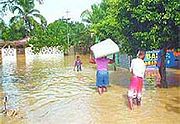 Winds from Tropical Storm Odette were relatively light across the Dominican Republic
, with a peak gust of 60 mph occurring in Santo Domingo
. The storm dropped heavy rainfall for several hours, amounting to a maximum of 9.07 inches (230 mm) in Isla Saona. Several other locations reported over 4 inches as well. The rainfall caused mudslides and flash flooding, forcing several rivers to overflow in combination with previous rains. In addition, a tornado was reported near Santo Domingo, destroying one house and uproofing several others.
The flooding and mudslides damaged up to 60,000 homes and destroyed 34. Gusty winds caused power outages. River flooding caused two bridges to collapse, isolating several communities. Landslides buried several roads, though authorities quickly repaired them. The rainfall also flooded fields, resulting in severe crop damage. As much as 85% of the banana crop was lost, while the coffee crop suffered losses shortly before harvest season. Crop damage totaled to around $8 million (2003 USD, $8.8 million 2006 USD). In addition, excess flooding contaminated water supplies, leaving several areas without clean water or sanitation.
In all, Tropical Storm Odette caused 8 deaths and 14 injuries, mostly due to flash flooding and mudslides. In addition, two indirect deaths are associated with the storm due to heart attacks. Neighboring Haiti
experienced little from the storm.
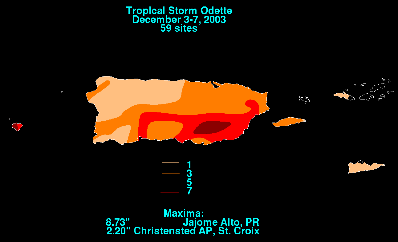 Though Odette passed 280 miles to the west of Mayagüez, Puerto Rico
, the storm caused moderate rainfall across Puerto Rico
and the United States Virgin Islands
. Rainfall in Puerto Rico was heaviest in the southeast, where a peak of 8.73 in (221.74 mm) was recorded in Jajome Alto. The storm also caused up to 2.2 in (55.9 mm) of rainfall in Christiansted
on Saint Croix
.
Odette's rainfall caused flooding throughout the island's rivers. The river flooding destroyed three bridges, resulting in $20,000 in damages (2003 USD). The flooding also caused a mudslide near a cemetery in Humacao
. The rainfall also covered numerous roads, though overall damage was minimal throughout Puerto Rico and the Virgin Islands.
When Odette formed on December 4, it became the first tropical storm since the beginning of the modern tropical cyclone
record to form in the Caribbean Sea
in the month of December; a documented December Caribbean hurricane occurred in 1822. However, Tropical Storm Karen, which formed in November 1989, persisted until December while located in the northwestern Caribbean Sea. In addition, Odette was the first Atlantic storm to form in the month of December since Hurricane Lili
in 1984.
The 2003 season was the first season since 1953
to have a pre-season storm and a post-season storm, with Ana
in April and Odette.
Caribbean Sea
The Caribbean Sea is a sea of the Atlantic Ocean located in the tropics of the Western hemisphere. It is bounded by Mexico and Central America to the west and southwest, to the north by the Greater Antilles, and to the east by the Lesser Antilles....
in December 2003. The 15th tropical storm of the 2003 Atlantic hurricane season
2003 Atlantic hurricane season
The 2003 Atlantic hurricane season was an active Atlantic hurricane season with tropical activity before and after the official bounds of the season – the first such occurrence in 50 years. The season produced 21 tropical cyclones, of which 16 developed into named storms; seven...
, Odette formed near the coast of Panama
Panama
Panama , officially the Republic of Panama , is the southernmost country of Central America. Situated on the isthmus connecting North and South America, it is bordered by Costa Rica to the northwest, Colombia to the southeast, the Caribbean Sea to the north and the Pacific Ocean to the south. The...
a few days after the official end of the Atlantic hurricane season
Atlantic hurricane season
The Atlantic hurricane season is the period in a year when hurricanes usually form in the Atlantic Ocean. Tropical cyclones in the North Atlantic are called hurricanes, tropical storms, or tropical depressions. In addition, there have been several storms over the years that have not been fully...
, and ultimately made landfall on the Dominican Republic
Dominican Republic
The Dominican Republic is a nation on the island of La Hispaniola, part of the Greater Antilles archipelago in the Caribbean region. The western third of the island is occupied by the nation of Haiti, making Hispaniola one of two Caribbean islands that are shared by two countries...
as a moderate tropical storm.
The storm caused heavy damage throughout the Dominican Republic from unusually heavy rainfall in December. Preparation preceding Odette's landfall resulted in only eight deaths and 14 injuries. Total damage is unknown, though crop damage in the Dominican Republic totaled to over $8 million (2003 USD, $8.8 million 2006 USD).
Meteorological history
By November 30, the last day of the Atlantic hurricane season, a stationary frontSurface weather analysis
Surface weather analysis is a special type of weather map that provides a view of weather elements over a geographical area at a specified time based on information from ground-based weather stations...
extended across eastern Cuba
Cuba
The Republic of Cuba is an island nation in the Caribbean. The nation of Cuba consists of the main island of Cuba, the Isla de la Juventud, and several archipelagos. Havana is the largest city in Cuba and the country's capital. Santiago de Cuba is the second largest city...
into the southwestern Caribbean Sea
Caribbean Sea
The Caribbean Sea is a sea of the Atlantic Ocean located in the tropics of the Western hemisphere. It is bounded by Mexico and Central America to the west and southwest, to the north by the Greater Antilles, and to the east by the Lesser Antilles....
. On December 1, a low pressure area
Low pressure area
A low-pressure area, or "low", is a region where the atmospheric pressure at sea level is below that of surrounding locations. Low-pressure systems form under areas of wind divergence which occur in upper levels of the troposphere. The formation process of a low-pressure area is known as...
developed within the frontal zone just north of Panama
Panama
Panama , officially the Republic of Panama , is the southernmost country of Central America. Situated on the isthmus connecting North and South America, it is bordered by Costa Rica to the northwest, Colombia to the southeast, the Caribbean Sea to the north and the Pacific Ocean to the south. The...
, and an anticyclone
Anticyclone
An anticyclone is a weather phenomenon defined by the United States' National Weather Service's glossary as "[a] large-scale circulation of winds around a central region of high atmospheric pressure, clockwise in the Northern Hemisphere, counterclockwise in the Southern Hemisphere"...
aloft produced good outflow
Outflow (meteorology)
Outflow, in meteorology, is air that flows outwards from a storm system. It is associated with ridging, or anticyclonic flow. In the low levels of the troposphere, outflow radiates from thunderstorms in the form of a wedge of rain-cooled air, which is visible as a thin rope-like cloud on weather...
over the low-level center. The low remained nearly stationary for the next several days, and it gradually became separated from the stationary front. Convection increased across the area due to moisture from the eastern Pacific Ocean
Pacific Ocean
The Pacific Ocean is the largest of the Earth's oceanic divisions. It extends from the Arctic in the north to the Southern Ocean in the south, bounded by Asia and Australia in the west, and the Americas in the east.At 165.2 million square kilometres in area, this largest division of the World...
and moderate divergence
Divergence
In vector calculus, divergence is a vector operator that measures the magnitude of a vector field's source or sink at a given point, in terms of a signed scalar. More technically, the divergence represents the volume density of the outward flux of a vector field from an infinitesimal volume around...
. Increased wind shear
Wind shear
Wind shear, sometimes referred to as windshear or wind gradient, is a difference in wind speed and direction over a relatively short distance in the atmosphere...
deteriorated the system on December 2, though convection redeveloped as the system started a northeast drift. On December 3 a mid-level circulation developed about 140 miles (225 km) north of the surface center. Convection increased and became better organized as a weak tropical wave
Tropical wave
Tropical waves, easterly waves, or tropical easterly waves, also known as African easterly waves in the Atlantic region, are a type of atmospheric trough, an elongated area of relatively low air pressure, oriented north to south, which move from east to west across the tropics causing areas of...
reached the area, and it is estimated the system developed into Tropical Depression Twenty at around 1200 UTC
Coordinated Universal Time
Coordinated Universal Time is the primary time standard by which the world regulates clocks and time. It is one of several closely related successors to Greenwich Mean Time. Computer servers, online services and other entities that rely on having a universally accepted time use UTC for that purpose...
on December 4 while located about 345 miles (560 km) south of Kingston, Jamaica
Kingston, Jamaica
Kingston is the capital and largest city of Jamaica, located on the southeastern coast of the island. It faces a natural harbour protected by the Palisadoes, a long sand spit which connects the town of Port Royal and the Norman Manley International Airport to the rest of the island...
; initially, the depression was forecast to track north-northeastward and pass over western Haiti
Haiti
Haiti , officially the Republic of Haiti , is a Caribbean country. It occupies the western, smaller portion of the island of Hispaniola, in the Greater Antillean archipelago, which it shares with the Dominican Republic. Ayiti was the indigenous Taíno or Amerindian name for the island...
.
Upon being classified as a tropical cyclone, the depression was embedded within the southwesterly flow between a ridge
Ridge (meteorology)
A ridge is an elongated region of relatively high atmospheric pressure, the opposite of a trough....
over the eastern Caribbean Sea and a mid-latitude trough
Trough (meteorology)
A trough is an elongated region of relatively low atmospheric pressure, often associated with fronts.Unlike fronts, there is not a universal symbol for a trough on a weather chart. The weather charts in some countries or regions mark troughs by a line. In the United States, a trough may be marked...
, which caused a steady east-northeast motion. The convection organized into a central dense overcast with a well-defined cloud band wrapping partially around the center, and based on satellite imagery estimates the depression was upgraded to tropical storm status; late on December 4, the National Hurricane Center
National Hurricane Center
The National Hurricane Center , located at Florida International University in Miami, Florida, is the division of the National Weather Service responsible for tracking and predicting weather systems within the tropics between the Prime Meridian and the 140th meridian west poleward to the 30th...
named the storm Odette
Odette (given name)
Odette is a French given name, a female form of Odet.*Odette, a character in the ballet Swan Lake*Odette Bancilhon, a French astronomer*Odette Barencey , French film actress*Odette de Champdivers Odette is a French given name, a female form of Odet.*Odette, a character in the ballet Swan...
. After being named, the storm intensified despite moderate southwesterly wind shear
Wind shear
Wind shear, sometimes referred to as windshear or wind gradient, is a difference in wind speed and direction over a relatively short distance in the atmosphere...
, and an eye feature
Eye (cyclone)
The eye is a region of mostly calm weather found at the center of strong tropical cyclones. The eye of a storm is a roughly circular area and typically 30–65 km in diameter. It is surrounded by the eyewall, a ring of towering thunderstorms where the second most severe weather of a cyclone...
became evident on microwave satellite imagery. Additionally, about three–fourths of a mid-level eyewall developed. The storm was assessed with winds of 40–50 mph (65–85 km/h), though the National Hurricane Center remarked the winds could have been stronger due to lack of structural data. The eye feature diminished as the convective structure deteriorated slightly, and Hurricane Hunters
Hurricane Hunters
The Hurricane Hunters are aircraft that fly into tropical cyclones in the North Atlantic Ocean and Northeastern Pacific Ocean for the specific purpose of directly measuring weather data in and around those storms. In the United States, the Air Force, Navy, and NOAA units have all participated in...
first flew into the storm at around 1200 UTC on December 5. Odette tracked over an area of warm sea surface temperatures, and the overall cloud pattern gradually improved; the Geophysical Fluid Dynamics Laboratory
Geophysical Fluid Dynamics Laboratory
The Geophysical Fluid Dynamics Laboratory is a laboratory in the National Oceanic and Atmospheric Administration /Office of Oceanic and Atmospheric Research . The current director is Dr. V...
predicted the storm to attain hurricane status. Early on December 6, a TRMM
Tropical Rainfall Measuring Mission
The Tropical Rainfall Measuring Mission is a joint space mission between NASA and the Japan Aerospace Exploration Agency designed to monitor and study tropical rainfall. The term refers to both the mission itself and the satellite that the mission uses to collect data...
overpass showed an 80 % closed eyewall, and at 0600 UTC Odette attained peak winds of 65 mph (100 km/h) while located about 245 miles (395 km/h) southwest of Santo Domingo
Santo Domingo
Santo Domingo, known officially as Santo Domingo de Guzmán, is the capital and largest city in the Dominican Republic. Its metropolitan population was 2,084,852 in 2003, and estimated at 3,294,385 in 2010. The city is located on the Caribbean Sea, at the mouth of the Ozama River...
, Dominican Republic
Dominican Republic
The Dominican Republic is a nation on the island of La Hispaniola, part of the Greater Antilles archipelago in the Caribbean region. The western third of the island is occupied by the nation of Haiti, making Hispaniola one of two Caribbean islands that are shared by two countries...
.
Upon reaching peak intensity, Odette had begun accelerating northeastward, which decreased wind shear and slightly increased its southwesterly outflow. The low-level center decelerated as it approached Hispaniola
Hispaniola
Hispaniola is a major island in the Caribbean, containing the two sovereign states of the Dominican Republic and Haiti. The island is located between the islands of Cuba to the west and Puerto Rico to the east, within the hurricane belt...
, though the convection continued quickly northeastward. Failing to maintain vertical organization, Odette weakened slightly and made landfall
Landfall (meteorology)
Landfall is the event of a tropical cyclone or a waterspout coming onto land after being over water. When a waterspout makes landfall it is reclassified as a tornado, which can then cause damage inland...
on Jaragua National Park
Jaragua National Park
Jaragua National Park is a national park of the Dominican Republic. Jaragua National Park is located in Pedenales Province in the extreme southwest of the Dominican Republic...
, in the Pedernales Province of the Dominican Republic, around 2300 UTC on December 6 with winds of 60 mph (95 km/h). The circulation became disrupted as it crossed the country, and on December 7 it emerged into the Atlantic Ocean with winds of 45 mph (75 km/h). It accelerated to the northeast ahead of an approaching cold front
Cold front
A cold front is defined as the leading edge of a cooler mass of air, replacing a warmer mass of air.-Development of cold front:The cooler and denser air wedges under the less-dense warmer air, lifting it...
, and late on December 7 Odette transitioned into an extratropical cyclone
Extratropical cyclone
Extratropical cyclones, sometimes called mid-latitude cyclones or wave cyclones, are a group of cyclones defined as synoptic scale low pressure weather systems that occur in the middle latitudes of the Earth having neither tropical nor polar characteristics, and are connected with fronts and...
as its center became embedded within the front. The remnants continued quickly northeastward before losing its identity within the frontal zone on December 9; the frontal zone that absorbed Odette also absorbed Tropical Storm Peter a few days later.
Preparations
Dominican Republic
The Dominican Republic is a nation on the island of La Hispaniola, part of the Greater Antilles archipelago in the Caribbean region. The western third of the island is occupied by the nation of Haiti, making Hispaniola one of two Caribbean islands that are shared by two countries...
government issued for the evacuation of more than 10,000 people, mostly from those living near rivers. At least 2,000 shelters were set up, capable of housing up to 800,000 people. In addition, the government mobilized the army to force those unwilling to leave from their homes. Such precautions were taken due to already saturated grounds from heavy rainfall three weeks prior.
A tropical storm watch
Tropical cyclone warnings and watches
Warnings and watches are two levels of alert issued by national weather forecasting bodies to coastal areas threatened by the imminent approach of a tropical cyclone of tropical storm or hurricane intensity. They are notices to the local population and civil authorities to make appropriate...
was issued between Santo Domingo
Santo Domingo
Santo Domingo, known officially as Santo Domingo de Guzmán, is the capital and largest city in the Dominican Republic. Its metropolitan population was 2,084,852 in 2003, and estimated at 3,294,385 in 2010. The city is located on the Caribbean Sea, at the mouth of the Ozama River...
and the Dominican Republic/Haiti
Haiti
Haiti , officially the Republic of Haiti , is a Caribbean country. It occupies the western, smaller portion of the island of Hispaniola, in the Greater Antillean archipelago, which it shares with the Dominican Republic. Ayiti was the indigenous Taíno or Amerindian name for the island...
border on December 4, 56 hours prior to landfall. This was raised to a tropical storm warning on December 5 while 32 hours before landfall. In addition, tropical storm warnings were issued for all of the Haitian coastline and Jamaica
Jamaica
Jamaica is an island nation of the Greater Antilles, in length, up to in width and 10,990 square kilometres in area. It is situated in the Caribbean Sea, about south of Cuba, and west of Hispaniola, the island harbouring the nation-states Haiti and the Dominican Republic...
.
Impact
While over the southwestern Caribbean Sea, Odette dropped heavy rainfall, including prior to its formation. For several days, the storm caused rains in PanamaPanama
Panama , officially the Republic of Panama , is the southernmost country of Central America. Situated on the isthmus connecting North and South America, it is bordered by Costa Rica to the northwest, Colombia to the southeast, the Caribbean Sea to the north and the Pacific Ocean to the south. The...
, Costa Rica
Costa Rica
Costa Rica , officially the Republic of Costa Rica is a multilingual, multiethnic and multicultural country in Central America, bordered by Nicaragua to the north, Panama to the southeast, the Pacific Ocean to the west and the Caribbean Sea to the east....
, and the east coast of Nicaragua
Nicaragua
Nicaragua is the largest country in the Central American American isthmus, bordered by Honduras to the north and Costa Rica to the south. The country is situated between 11 and 14 degrees north of the Equator in the Northern Hemisphere, which places it entirely within the tropics. The Pacific Ocean...
. In Colombia
Colombia
Colombia, officially the Republic of Colombia , is a unitary constitutional republic comprising thirty-two departments. The country is located in northwestern South America, bordered to the east by Venezuela and Brazil; to the south by Ecuador and Peru; to the north by the Caribbean Sea; to the...
, the storm caused rainfall totals of up to 8 inches (200 mm) in Puerto Colombia
Puerto Colombia
Puerto Colombia is a town and municipality in Atlántico Department, Colombia. Famous for its "Pier of Puerto Colombia". Duties were later transferred to the larger and modern Port of Barranquilla in Bocas de Cenizas, the mouth of the Magdalena River in the Caribbean sea.-External links:...
. In Jamaica
Jamaica
Jamaica is an island nation of the Greater Antilles, in length, up to in width and 10,990 square kilometres in area. It is situated in the Caribbean Sea, about south of Cuba, and west of Hispaniola, the island harbouring the nation-states Haiti and the Dominican Republic...
, the storm dropped moderate rainfall, flooding several roads in Saint Ann
Saint Ann Parish, Jamaica
Saint Ann is the largest parish in Jamaica. It is situated on the north coast of the island, in the county of Middlesex, roughly halfway between the eastern and western ends of the island. It is often called 'the Garden Parish of Jamaica' on account of its natural beauty...
and Saint Mary Parishes
Saint Mary Parish, Jamaica
Saint Mary is a parish located in the northeast section of Jamaica. With a population of 115,000 it is one of Jamaica's smallest parishes, located in the county of Middlesex. Its chief town and capital is Port Maria, located on the coast. It is also the birthplace of established dancehall reggae...
. Odette caused moderate damage and 8 deaths in the Dominican Republic
Dominican Republic
The Dominican Republic is a nation on the island of La Hispaniola, part of the Greater Antilles archipelago in the Caribbean region. The western third of the island is occupied by the nation of Haiti, making Hispaniola one of two Caribbean islands that are shared by two countries...
.
Dominican Republic
Dominican Republic
The Dominican Republic is a nation on the island of La Hispaniola, part of the Greater Antilles archipelago in the Caribbean region. The western third of the island is occupied by the nation of Haiti, making Hispaniola one of two Caribbean islands that are shared by two countries...
, with a peak gust of 60 mph occurring in Santo Domingo
Santo Domingo
Santo Domingo, known officially as Santo Domingo de Guzmán, is the capital and largest city in the Dominican Republic. Its metropolitan population was 2,084,852 in 2003, and estimated at 3,294,385 in 2010. The city is located on the Caribbean Sea, at the mouth of the Ozama River...
. The storm dropped heavy rainfall for several hours, amounting to a maximum of 9.07 inches (230 mm) in Isla Saona. Several other locations reported over 4 inches as well. The rainfall caused mudslides and flash flooding, forcing several rivers to overflow in combination with previous rains. In addition, a tornado was reported near Santo Domingo, destroying one house and uproofing several others.
The flooding and mudslides damaged up to 60,000 homes and destroyed 34. Gusty winds caused power outages. River flooding caused two bridges to collapse, isolating several communities. Landslides buried several roads, though authorities quickly repaired them. The rainfall also flooded fields, resulting in severe crop damage. As much as 85% of the banana crop was lost, while the coffee crop suffered losses shortly before harvest season. Crop damage totaled to around $8 million (2003 USD, $8.8 million 2006 USD). In addition, excess flooding contaminated water supplies, leaving several areas without clean water or sanitation.
In all, Tropical Storm Odette caused 8 deaths and 14 injuries, mostly due to flash flooding and mudslides. In addition, two indirect deaths are associated with the storm due to heart attacks. Neighboring Haiti
Haiti
Haiti , officially the Republic of Haiti , is a Caribbean country. It occupies the western, smaller portion of the island of Hispaniola, in the Greater Antillean archipelago, which it shares with the Dominican Republic. Ayiti was the indigenous Taíno or Amerindian name for the island...
experienced little from the storm.
Puerto Rico and United States Virgin Islands
Mayagüez, Puerto Rico
Mayagüez is the eighth-largest municipality of Puerto Rico. Originally founded as "Nuestra Señora de la Candelaria" it is also known as "La Sultana del Oeste" , "Ciudad de las Aguas Puras" , or "Ciudad del Mangó"...
, the storm caused moderate rainfall across Puerto Rico
Puerto Rico
Puerto Rico , officially the Commonwealth of Puerto Rico , is an unincorporated territory of the United States, located in the northeastern Caribbean, east of the Dominican Republic and west of both the United States Virgin Islands and the British Virgin Islands.Puerto Rico comprises an...
and the United States Virgin Islands
United States Virgin Islands
The Virgin Islands of the United States are a group of islands in the Caribbean that are an insular area of the United States. The islands are geographically part of the Virgin Islands archipelago and are located in the Leeward Islands of the Lesser Antilles.The U.S...
. Rainfall in Puerto Rico was heaviest in the southeast, where a peak of 8.73 in (221.74 mm) was recorded in Jajome Alto. The storm also caused up to 2.2 in (55.9 mm) of rainfall in Christiansted
Christiansted, U.S. Virgin Islands
Christiansted is a town on Saint Croix, one of the main islands composing the United States Virgin Islands, an unincorporated territory of the United States. It is a former capital of the Danish West Indies and home to the Christiansted National Historic Site...
on Saint Croix
Saint Croix, U.S. Virgin Islands
Saint Croix is an island in the Caribbean Sea, and a county and constituent district of the United States Virgin Islands , an unincorporated territory of the United States. Formerly the Danish West Indies, they were sold to the United States by Denmark in the Treaty of the Danish West Indies of...
.
Odette's rainfall caused flooding throughout the island's rivers. The river flooding destroyed three bridges, resulting in $20,000 in damages (2003 USD). The flooding also caused a mudslide near a cemetery in Humacao
Humacao, Puerto Rico
Humacao is a city in Puerto Rico located in the eastern coast of the island, north of Yabucoa; south of Naguabo; east of Las Piedras; and west of Vieques Passage. Humacao is spread over 10 wards and Humacao Pueblo...
. The rainfall also covered numerous roads, though overall damage was minimal throughout Puerto Rico and the Virgin Islands.
Aftermath and records
In all, 65,000 people were affected by Tropical Storm Odette. The Dominican Republic Red Cross and Red Crescent deployed 105 volunteers to the impacted areas, primarily in the area of Monte Cristi. The organization provided food and hygiene kits to thousands of people, as well as mosquito nets. The Red Cross also gave a 5,000 liter water tank for the citizens in Monte Cristi, an area without clean water or sanitation.When Odette formed on December 4, it became the first tropical storm since the beginning of the modern tropical cyclone
Tropical cyclone
A tropical cyclone is a storm system characterized by a large low-pressure center and numerous thunderstorms that produce strong winds and heavy rain. Tropical cyclones strengthen when water evaporated from the ocean is released as the saturated air rises, resulting in condensation of water vapor...
record to form in the Caribbean Sea
Caribbean Sea
The Caribbean Sea is a sea of the Atlantic Ocean located in the tropics of the Western hemisphere. It is bounded by Mexico and Central America to the west and southwest, to the north by the Greater Antilles, and to the east by the Lesser Antilles....
in the month of December; a documented December Caribbean hurricane occurred in 1822. However, Tropical Storm Karen, which formed in November 1989, persisted until December while located in the northwestern Caribbean Sea. In addition, Odette was the first Atlantic storm to form in the month of December since Hurricane Lili
Hurricane Lili (1984)
Hurricane Lili was one of only five Atlantic tropical cyclones on record to reach hurricane status in the month of December. The final of thirteen tropical storms in the 1984 Atlantic hurricane season, Lili developed as a subtropical cyclone which originated from a frontal trough to the south of...
in 1984.
The 2003 season was the first season since 1953
1953 Atlantic hurricane season
The 1953 Atlantic hurricane season was the first time an organized list of female names was used to name Atlantic storms. It officially began on June 15, and lasted until November 15, although activity occurred both before and after the season's limits...
to have a pre-season storm and a post-season storm, with Ana
Tropical Storm Ana (2003)
Tropical Storm Ana was the only tropical cyclone on record in the Atlantic basin to form during the month of April. The first tropical cyclone of the season, it developed as a subtropical cyclone from a non-tropical low on April 20 to the west of Bermuda...
in April and Odette.
See also
- List of tropical cyclones
- List of wettest tropical cyclones by country
- Timeline of the 2003 Atlantic hurricane seasonTimeline of the 2003 Atlantic hurricane seasonThe 2003 Atlantic hurricane season was an active Atlantic hurricane season with tropical activity before and after the official bounds of the season – the first such occurrence in 50 years. The season officially began on June 1, 2003 and ended on November 30...
- List of storms in the 2003 Atlantic hurricane season