
.gif)
List of North Carolina hurricanes (1950–1979)
Encyclopedia
The list of North Carolina hurricanes between 1950 and 1979 encompasses 79 tropical
or subtropical cyclone
s that affected the U.S. state
of North Carolina
. Collectively, cyclones in North Carolina during that time period resulted in 37 total fatalities during the period, as well as about $3 billion in damage in 2008 USD
. A cyclone affected the state in every year during the three decades, and in three seasons a total of five cyclones impacted the state. The strongest hurricane to hit the state during the time period was Hurricane Hazel
, which struck the state as a Category 4 hurricane on the Saffir-Simpson Hurricane Scale
. Hazel was both the costliest and deadliest cyclone during the period, causing over $1 billion in damage (2008 USD) and 19 deaths. Most storms affected the state in September, though cyclones impacted the state between May and October.


Tropical cyclone
A tropical cyclone is a storm system characterized by a large low-pressure center and numerous thunderstorms that produce strong winds and heavy rain. Tropical cyclones strengthen when water evaporated from the ocean is released as the saturated air rises, resulting in condensation of water vapor...
or subtropical cyclone
Subtropical cyclone
A subtropical cyclone is a weather system that has some characteristics of a tropical and an extratropical cyclone. As early as the 1950s, meteorologists were unclear whether they should be characterized as tropical or extratropical cyclones. They were officially recognized by the National...
s that affected the U.S. state
U.S. state
A U.S. state is any one of the 50 federated states of the United States of America that share sovereignty with the federal government. Because of this shared sovereignty, an American is a citizen both of the federal entity and of his or her state of domicile. Four states use the official title of...
of North Carolina
North Carolina
North Carolina is a state located in the southeastern United States. The state borders South Carolina and Georgia to the south, Tennessee to the west and Virginia to the north. North Carolina contains 100 counties. Its capital is Raleigh, and its largest city is Charlotte...
. Collectively, cyclones in North Carolina during that time period resulted in 37 total fatalities during the period, as well as about $3 billion in damage in 2008 USD
United States dollar
The United States dollar , also referred to as the American dollar, is the official currency of the United States of America. It is divided into 100 smaller units called cents or pennies....
. A cyclone affected the state in every year during the three decades, and in three seasons a total of five cyclones impacted the state. The strongest hurricane to hit the state during the time period was Hurricane Hazel
Hurricane Hazel
Hurricane Hazel was the deadliest and costliest hurricane of the 1954 Atlantic hurricane season. The storm killed as many as 1,000 people in Haiti before striking the United States near the border between North and South Carolina, as a Category 4 hurricane...
, which struck the state as a Category 4 hurricane on the Saffir-Simpson Hurricane Scale
Saffir-Simpson Hurricane Scale
The Saffir–Simpson Hurricane Scale , or the Saffir–Simpson Hurricane Wind Scale , classifies hurricanes — Western Hemisphere tropical cyclones that exceed the intensities of tropical depressions and tropical storms — into five categories distinguished by the intensities of their sustained winds...
. Hazel was both the costliest and deadliest cyclone during the period, causing over $1 billion in damage (2008 USD) and 19 deaths. Most storms affected the state in September, though cyclones impacted the state between May and October.
1950s
- August 20, 1950 – Hurricane AbleHurricane Able (1950)Hurricane Able was the first named tropical cyclone in the Atlantic Ocean, and was also the first of a record eight major hurricanes in the 1950 Atlantic hurricane season. Its development was confirmed on August 12 by the Hurricane Hunters, which is a group that intentionally flies into a...
brushes the Outer BanksOuter BanksThe Outer Banks is a 200-mile long string of narrow barrier islands off the coast of North Carolina, beginning in the southeastern corner of Virginia Beach on the east coast of the United States....
with light winds and rough waves. - September 7, 1950 – Former Hurricane EasyHurricane Easy (1950)Hurricane Easy was the fifth tropical storm, hurricane, and major hurricane of the 1950 Atlantic hurricane season. The hurricane developed in the western Caribbean Sea on September 1, and tracked northeastward. After crossing Cuba, the hurricane rapidly strengthened in the eastern Gulf of Mexico to...
weakens to tropical depression status over GeorgiaGeorgia (U.S. state)Georgia is a state located in the southeastern United States. It was established in 1732, the last of the original Thirteen Colonies. The state is named after King George II of Great Britain. Georgia was the fourth state to ratify the United States Constitution, on January 2, 1788...
, bringing heavy rainfall to North Carolina which peaks at 9.14 inches (232 mm) in Yancey CountyYancey County, North Carolina-Demographics:As of the census of 2000, there were 17,774 people, 7,472 households, and 5,372 families residing in the county. The population density was 57 people per square mile . There were 9,729 housing units at an average density of 31 per square mile...
. - September 11, 1950 – Hurricane DogHurricane Dog (1950)Hurricane Dog was the most intense hurricane in the 1950 Atlantic hurricane season. The fourth named storm of the season, Dog developed on August 30 to the east of Antigua; after passing through the northern Lesser Antilles, it turned to the north and intensified into a Category 5 hurricane...
skirts the coastline as it remains well offshore. - May 21, 1951 – Hurricane AbleHurricane Able (1951)Hurricane Able was the strongest recorded hurricane outside of the typical Atlantic hurricane season. The first tropical cyclone in 1951, Able developed from a trough of low pressure on May 15 about 300 miles south of Bermuda...
produces high surf along the coastline. - October 4, 1951 – Hurricane How brushes the coastline with heavy surf.
- August 31, 1952 – Tropical Storm Able crosses the center portion of the state, causing moderate precipitation and stream flooding.
- August 14, 1953 – Hurricane Barbara moves ashore near Morehead CityMorehead City, North CarolinaMorehead City is a port city in Carteret County, North Carolina, United States. The population was 8,661 at the 2010 census. Morehead City celebrated the 150th anniversary of its founding on May 5, 2007...
with 90 miles per hour (145 km/h) wind gusts and rainfall, which causes about $1.1 million in damage (1953 USD, $8.9 million 2008 USD), mostly from crop damage; one person drowned due to the storm. - September 28, 1953 – Moisture from former Hurricane FlorenceHurricane Florence (1953)Hurricane Florence was a minimal Atlantic hurricane that struck the Florida Panhandle in September of the 1953 season. The eighth storm and fifth hurricane of the season, Florence developed in the western Caribbean from a tropical wave near Jamaica on September 23. It produced heavy rainfall...
brings moderate rainfall to the state. - August 30, 1954 – Hurricane CarolHurricane CarolHurricane Carol was among the worst tropical cyclones to affect the New England region of the United States. It developed from a tropical wave near the Bahamas on August 25, 1954, and gradually strengthened as it moved northwestward. On August 27, Carol intensified to reach winds of , but weakened...
passes just east of the state, producing 100 miles per hour (161 km/h) wind gusts and rough waves along the Outer Banks; damage is minor, largely limited to crop damage. - September 10, 1954 – Strong waves from Hurricane EdnaHurricane EdnaHurricane Edna was a deadly and destructive major hurricane that impacted the United States East Coast in September of the 1954 Atlantic hurricane season. It was one of two hurricanes to strike Massachusetts in that year, the other being Hurricane Carol...
cause widespread but minor damage to the Outer Banks. - October 15, 1954 – Hurricane HazelHurricane HazelHurricane Hazel was the deadliest and costliest hurricane of the 1954 Atlantic hurricane season. The storm killed as many as 1,000 people in Haiti before striking the United States near the border between North and South Carolina, as a Category 4 hurricane...
moves ashore near the South Carolina/North Carolina border as a Category 4 hurricane, destroying 15,000 buildings and damaging 39,000 more. Damage is greatest in Brunswick CountyBrunswick County, North Carolina-External links:*******....
, where great coastal damage occurs due to a powerful storm tide. Considered the most destructive hurricane to affect the state at the time, the hurricane causes an estimated damage total of $136 million (1954 USD, $1.09 billion 2008 USD). Hurricane Hazel injures 200 and kills 19 people in the state. - August 12, 1955 – Hurricane ConnieHurricane ConnieHurricane Connie was the first in a series of hurricanes to strike North Carolina during the 1955 Atlantic hurricane season. Connie struck as a Category 1, causing major flooding and inflicting extensive damage to the Outer Banks and inland to Raleigh....
strikes the Outer Banks and produces severe beach erosion. It drops up to 12 inches (305 mm) of precipitation, which floods large areas of crop lands. No deaths are reported in the state, and damage accrues to $80 million (1955 USD, $640 million 2008 USD). - August 17, 1955 – Hurricane DianeHurricane DianeHurricane Diane was one of three hurricanes to hit North Carolina during the 1955 Atlantic hurricane season, striking an area that had been hit by Hurricane Connie five days earlier...
makes landfall near Wilmington, producing further beach erosion and flooding just five days after the previous hurricane. Wind damage is light, and no fatalities or injuries occur in the state. - September 19, 1955 – Moving ashore near Morehead City, Hurricane IoneHurricane IoneHurricane Ione was a strong, Category 3 hurricane that affected North Carolina in September 1955, bringing high winds and significant rainfall. It came on the heels of Hurricanes Connie and Diane, and compounded problems already caused by the two earlier hurricanes...
drops heavy rainfall which peaks at 16.6 inches (422 mm) near MaysvilleMaysville, North CarolinaMaysville is a town in Jones County, North Carolina, United States. The population was 959 in 2008. It is part of the New Bern, North Carolina Micropolitan Statistical Area.-Geography:Maysville is located at ....
. The combination of high tides and rainfall leaves large portions of eastern North Carolina flooded, including large areas of crop lands. The hurricane kills seven, of which two indirectly due to traffic accidents, and damage totals to $88 million (1955 USD, $708 million 2008 USD). - August 16, 1956 – Hurricane BetsyHurricane Betsy (1956)Hurricane Betsy in 1956 was the first Atlantic hurricane to make landfall in Puerto Rico in 24 years. The third tropical cyclone of the 1956 Atlantic hurricane season, Betsy developed from a tropical wave on August 9 to the east of the Lesser Antilles. It rapidly developed into a...
brushes the coastline with rainfall. - September 8, 1956 – The interaction between a high pressure system and Tropical Storm Carla produces moderate winds along the coastline.
- September 26, 1956 – The extratropical remainsExtratropical cycloneExtratropical cyclones, sometimes called mid-latitude cyclones or wave cyclones, are a group of cyclones defined as synoptic scale low pressure weather systems that occur in the middle latitudes of the Earth having neither tropical nor polar characteristics, and are connected with fronts and...
of Hurricane FlossyHurricane Flossy (1956)Hurricane Flossy originated from a tropical disturbance in the eastern Pacific Ocean and moved across Central America into the Gulf of Mexico as a tropical depression on September 21, which became a tropical storm on September 22 and a hurricane on September 23...
produce moderate rainfall across much of the state, which is beneficial after previous dry conditions. - October, 1956 – A quasi-tropical storm passes over the Outer Banks.
- September 9, 1957 – The remnants of Tropical Storm Debbie brings light rainfall to the state.
- September 18, 1957 – A weak tropical depression crosses the state.
- August 28, 1958 – Hurricane Daisy passes just offshore, producing light winds but little damage.
- September 27, 1958 – Hurricane HeleneHurricane Helene (1958)Hurricane Helene was the strongest hurricane in the 1958 Atlantic hurricane season, reaching peak winds of and tied with Hurricane Ilsa as the strongest tropical cyclone of the season. The system moved to the north of the West Indies and skirted the coast of the Southeast United States before...
parallels the coastline just offshore with wind gusts reaching 135 miles per hour (217 km/h). The winds cause moderate structural and crop damage, totaling about $11 million (1958 USD, $82 million 2008 USD). - July 10, 1959 – Tropical Depression CindyHurricane Cindy (1959)Hurricane Cindy impacted the Carolinas, the Mid-Atlantic states, New England, and the Canadian Maritime Provinces during the 1959 Atlantic hurricane season. The third storm of the season, Cindy originated from a low-pressure area associated with a cold front located east of northern Florida...
crosses through the state, producing heavy rainfall and some tornadoes. - September 30, 1959 – Former Hurricane GracieHurricane GracieHurricane Gracie was a major hurricane that formed in September 1959, the strongest during the 1959 Atlantic hurricane season and the most intense to strike the United States since Hurricane Hazel in 1954...
passes through the central portion of the state and causes moderate tides near the coastline, as well as heavy rainfall in the inland mountains region.
1960s
- July 29, 1960 – Crossing the eastern portion of the state, Tropical Storm Brenda produces locally heavy rainfall and gusty winds.
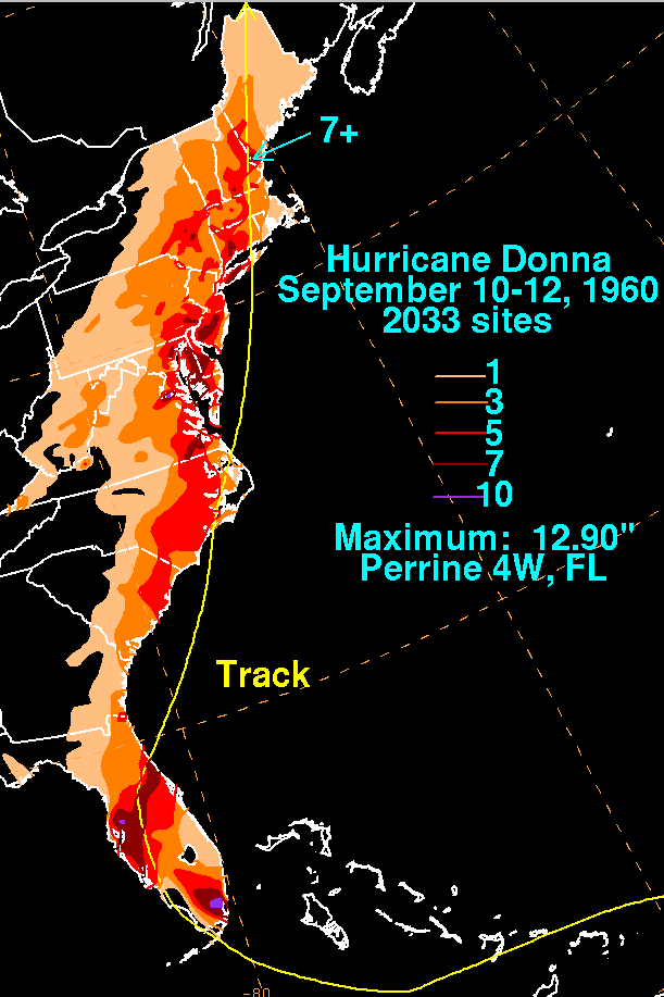
- September 12, 1960 – Hurricane DonnaHurricane DonnaHurricane Donna in the 1960 Atlantic hurricane season was a Cape Verde-type hurricane which moved across the Leeward Islands, Puerto Rico, Hispanola, Cuba, The Bahamas, and every state on the East Coast of the United States...
moves across the Outer Banks, causing heavy damage from the combination of high winds and waves. Up to a distance of 50 miles (80 km) inland, strong winds down trees and crops, and damage in the state totals $56.5 million (1960 USD, $422 million 2008 USD). Across the state, over 100 people are injured, and eight people are killed, of which five directly. - September 14, 1961 – A tropical storm strikes the state, though no serious damage is reported.
- September 20, 1961 – Hurricane EstherHurricane Esther (1961)Hurricane Esther was the fifth named storm and fifth hurricane of the 1961 Atlantic hurricane season. A long-lived Category 4 Cape Verde-type hurricane, Esther spent its lifetime offshore, before moving up the East Coast of the United States...
passes offshore with slightly above normal tides and light winds. - September 28, 1962 – Tropical Storm Alma attains hurricane status near the Outer Banks, though winds on land are minor, and little damage is reported.
- October 12, 1962 – The interaction between Hurricane Ella and a high pressure system produces above normal tides and beach erosion along the coastline.
- October, 1963 – Hurricane GinnyHurricane GinnyHurricane Ginny in the 1963 Atlantic hurricane season was the latest Atlantic hurricane on record to affect the U.S. state of Maine. It developed on October 16 over the Bahamas, although it was not initially a fully tropical cyclone. As it moved to the north and later northwest, Ginny...
affects the coastline for about a week with rough winds, which cause severe beach erosion; the hurricane destroys one house, though overall damage was limited. - August 30, 1964 – Former Hurricane CleoHurricane CleoHurricane Cleo was the third named storm, first hurricane, and first major hurricane of the 1964 Atlantic hurricane season. Cleo was one of the longest-lived storms of the season...
enters the state as a tropical depression, spawning several tornadoes and dropping heavy rainfall. - September 13, 1964 – Paralleling the coastline just offshore, Tropical Storm DoraHurricane DoraHurricane Dora was the first tropical cyclone on record to make landfall over the extreme northeast coast of Florida. Dora was also the first storm to produce hurricane force winds to Jacksonville, Florida in the almost 80 years of record keeping. Dora killed five people and left over...
causes some beach erosion and precipitation. - September 21, 1964 – Hurricane Gladys causes high tides along the coastline.
- October 5, 1964 – The remnants of Hurricane HildaHurricane HildaHurricane Hilda was the third hurricane to make landfall in the United States during the 1964 Atlantic hurricane season. Originating near Cuba, the cyclone intensified while moving through the Gulf of Mexico, and became a Category 4 hurricane in the Gulf of Mexico before striking Louisiana in...
drop moderate to heavy precipitation across the state. - October 16, 1964 – Hurricane Isbell makes landfall near Morehead City with gusty winds and locally heavy rainfall; damage is minor.
- June 16, 1965 – A former tropical storm crosses through the state.
- September 12, 1965 – After becoming extratropicalExtratropical cycloneExtratropical cyclones, sometimes called mid-latitude cyclones or wave cyclones, are a group of cyclones defined as synoptic scale low pressure weather systems that occur in the middle latitudes of the Earth having neither tropical nor polar characteristics, and are connected with fronts and...
over the Ohio Valley, the remnants of Hurricane BetsyHurricane BetsyHurricane Betsy was a Category 4 hurricane of the 1965 Atlantic hurricane season which caused enormous damage in the Bahamas, Florida, and Louisiana. Betsy made its most intense landfall near the mouth of the Mississippi River, causing significant flooding of the waters of Lake Pontchartrain into...
bring light rainfall to the state. - June 11, 1966 – Hurricane AlmaHurricane Alma (1966)Hurricane Alma was a rare June major hurricane in the 1966 Atlantic hurricane season. It was the earliest continental U.S. hurricane strike within any season since 1908...
parallels the coastline offshore, producing above normal tides and moderate precipitation. - August 29, 1966 – Rough seas from Hurricane Faith cause four drownings along the coastline.
- September 16, 1967 – Tropical Storm Doria enters the state from the northeast with slightly above normal tides; damage is minor.
- June 9, 1968 – Former Hurricane AbbyHurricane Abby (1968)Hurricane Abby was the first named storm and first hurricane of the 1968 Atlantic hurricane season. Abby was one of four tropical cyclones to strike Florida during the 1968 season and one of three tropical cyclones to form in June 1968...
moves across much of the state, dropping moderate precipitation and spawning a tornado near Charlotte. - October 19, 1968 – Hurricane GladysHurricane Gladys (1968)Hurricane Gladys was the most destructive hurricane in the 1968 Atlantic hurricane season, causing over $100 million in damage and ten deaths. The last storm of the season, it caused heavy rainfall along its path through the Western Caribbean Sea, Florida, and up through Atlantic Canada...
passes just offshore, bringing moderate to heavy rainfall across the state; the rainfall is beneficial due to previously dry conditions. - August 20, 1969 – The remnants of Hurricane CamilleHurricane CamilleHurricane Camille was the third and strongest tropical cyclone and second hurricane during the 1969 Atlantic hurricane season. The second of three catastrophic Category 5 hurricanes to make landfall in the United States during the 20th century , which it did near the mouth of the Mississippi River...
drop light rainfall across the western portion of the state. - September 9, 1969 – Hurricane GerdaHurricane Gerda (1969)Hurricane Gerda was a North Atlantic tropical cyclone that formed during the 1969 Atlantic hurricane season. It was the seventh named storm, fifth hurricane and third major hurricane of the 1969 season. Gerda formed on September 6 and crossed Florida as a tropical depression...
brushes the coastline with light winds and rainfall. - September 24, 1969 – A tropical depression brings light precipitation to much of the state.
- October 15, 1969 – Originally predicted to strike the Outer Banks, Hurricane Kara passes offshore, only affecting small craft.
1970s
- May 26, 1970 – The remnants of Hurricane Alma cross the eastern portion of the state.
- August 17, 1970 – An unnamed tropical depression moves across the Outer BanksOuter BanksThe Outer Banks is a 200-mile long string of narrow barrier islands off the coast of North Carolina, beginning in the southeastern corner of Virginia Beach on the east coast of the United States....
, bringing locally heavy rainfall and gusty winds. - August 17, 1971 – A tropical depression moving through the southeastern United States drops up to 12 inches (305 mm) in the state.
- August 27, 1971 – Tropical Storm DoriaTropical Storm Doria (1971)Tropical Storm Doria was the costliest tropical cyclone in the 1971 Atlantic hurricane season. The fifth tropical storm of the season, Doria developed from a tropical wave on August 20 to the east of the Lesser Antilles, and after five days without development it attained tropical storm status to...
makes landfallLandfall (meteorology)Landfall is the event of a tropical cyclone or a waterspout coming onto land after being over water. When a waterspout makes landfall it is reclassified as a tornado, which can then cause damage inland...
near Morehead CityMorehead City, North CarolinaMorehead City is a port city in Carteret County, North Carolina, United States. The population was 8,661 at the 2010 census. Morehead City celebrated the 150th anniversary of its founding on May 5, 2007...
, which causes mudslides from heavy rainfall but overall light damage. - September 12, 1971 – A tropical depression dissipates in the state after entering through South CarolinaSouth CarolinaSouth Carolina is a state in the Deep South of the United States that borders Georgia to the south, North Carolina to the north, and the Atlantic Ocean to the east. Originally part of the Province of Carolina, the Province of South Carolina was one of the 13 colonies that declared independence...
. - September 19, 1971 – The remnants of Hurricane Edith drop moderate precipitation in the western portion of the state.
- September 30, 1971 – Hurricane Ginger makes landfall near Atlantic BeachAtlantic Beach, North Carolina-Demographics:As of the census of 2008, there were 1,815 people, 971 households, and 498 families residing in the town. The population density was . There were 4,728 housing units at an average density of 2,206.0 per square mile...
and slowly moves across the state, dropping heavy rainfall peaking at 15.6 inches (396 mm) at Bodie IslandBodie IslandBodie Island is a long, narrow barrier peninsula that forms the northernmost portion of the Outer Banks of North Carolina. The land that is most commonly referred to as Bodie Island was at one time a true island, however the inlet separating it from the Currituck Banks peninsula in the north closed...
. The precipitation causes severe crop damage totaling $10 million (1971 USD, $53 million 2008 USD). - May 26, 1972 – Subtropical Storm Alpha attains gale force winds to the southeast of the Outer Banks after dropping 6.97 inches (177 mm) of rainfall at OcracokeOcracoke, North CarolinaOcracoke is a census-designated place and unincorporated town located at the southern end of Ocracoke Island, located entirely within Hyde County, North Carolina. The population was 769 as of the 2000 census...
. - June 21, 1972 – The remnants of Hurricane AgnesHurricane AgnesHurricane Agnes was the first tropical storm and first hurricane of the 1972 Atlantic hurricane season. A rare June hurricane, it made landfall on the Florida Panhandle before moving northeastward and ravaging the Mid-Atlantic region as a tropical storm...
re-attain tropical storm status over the northeastern portion of the state. The interaction with a low to its west results in heavy rainfall of up to 10.6 inches (269 mm) on Mount MitchellMount Mitchell (North Carolina)Mount Mitchell is the highest peak of the Appalachian Mountains and the highest peak in the eastern United States. It was the highest point in any state of the United States until Texas joined the union in 1845. The nearest higher point east of the Rocky Mountains is Harney Peak in the Black Hills...
, which causes record river flooding and severe crop damage. Throughout the state, Agnes causes two deaths and $6.56 million in damage (1972 USD, $33.8 million 2008 USD). - July 12, 1972 – A tropical depression moves ashore near the South Carolina/North Carolina border.
- August 31, 1972 – Attaining tropical storm status to the southeast of the state, Tropical Storm CarrieTropical Storm Carrie (1972)Tropical Storm Carrie was a strong tropical storm that affected the East Coast of the United States in early September 1972. The third tropical cyclone of the 1972 Atlantic hurricane season, Carrie formed on August 29 from a complex sequence of meteorological events starting with the emergence of a...
drops light precipitation along the coastline. - September 15, 1972 – The remnants of Hurricane Dawn dissipate offshore of South Carolina, dropping very light rainfall in North Carolina.
- October 24, 1973 – The remnants of Tropical Depression Gilda reform into a large subtropical cycloneSubtropical cycloneA subtropical cyclone is a weather system that has some characteristics of a tropical and an extratropical cyclone. As early as the 1950s, meteorologists were unclear whether they should be characterized as tropical or extratropical cyclones. They were officially recognized by the National...
, which produces gale force winds and beach erosion along the Outer Banks. - June 26, 1974 – The first subtropical storm of the season brushes the coastline with light rainfall.
- June 26, 1974 – A tropical depression transitions into an extratropical cycloneExtratropical cycloneExtratropical cyclones, sometimes called mid-latitude cyclones or wave cyclones, are a group of cyclones defined as synoptic scale low pressure weather systems that occur in the middle latitudes of the Earth having neither tropical nor polar characteristics, and are connected with fronts and...
, with its remnants dropping moderate precipitation near the coastline. - October 8, 1974 – The fourth subtropical storm of the season produces rainfall in the eastern portion of the state as it parallels offshore.
- June 29, 1975 – A tropical depression intensifies into Tropical Storm Amy, after brushing the Outer Banks with light rainfall.
- September 24, 1975 – The remnants of Hurricane EloiseHurricane EloiseHurricane Eloise was the most destructive tropical cyclone of the 1975 Atlantic hurricane season. The fifth tropical storm, fourth hurricane, and second major hurricane of the season, Eloise formed as a tropical depression on September 13 to the east of the Virgin Islands...
become extratropical over eastern TennesseeTennesseeTennessee is a U.S. state located in the Southeastern United States. It has a population of 6,346,105, making it the nation's 17th-largest state by population, and covers , making it the 36th-largest by total land area...
, spawning a few tornadoes and dropping moderate precipitation across western North Carolina. - October 2, 1975 – Hurricane Gladys threatens the Outer Banks with rough waves, but remains well offshore.
- October 27, 1975 – Tropical Storm HallieTropical Storm Hallie (1975)Tropical Storm Hallie was a tropical storm during October 1975 that existed as three types of cyclones: subtropical, tropical, and extratropical. The eighth and final named storm of the 1975 Atlantic hurricane season, Hallie formed on October 24 from the complex interaction of several weather systems...
brushes the coastline with light precipitation. - May 24, 1976 – Subtropical Storm One drops light rainfall near the coastline as parallels the coastline.
- August 9, 1976 – Hurricane Belle passes just offshore, producing strong wind gusts and a moderate storm tide that left areas flooded.
- August 20, 1976 – Tropical Storm Dottie moves ashore along South Carolina, causing beach erosion and locally heavy rainfall in southern North Carolina.
- September 15, 1976 – A subtropical depression brings moderate rainfall as it crosses the state.
- September 6, 1977 – The tropical depression that later becomes Hurricane Clara brushes the coastline with light precipitation.
- September 9, 1977 – The remnants of Hurricane Babe near the South Carolina/North Carolina border, producing rainfall across the entire state that peaks at 8.99 inches (228 mm) in Transylvania CountyTransylvania County, North CarolinaTransylvania County is a county located in the U.S. state of North Carolina. As of 2010, the population was 33,090. Its county seat is Brevard.- History :The county was formed in 1861 from parts of Henderson County and Jackson County...
. - August 29, 1978 – Tropical Storm DebraTropical Storm Debra (1978)Tropical Storm Debra was the second of two tropical storms to hit the United States in the 1978 Atlantic hurricane season. The fourth named storm of the season, Debra developed from the interaction between a high-altitude cold low and a lower tropical wave in the Gulf of Mexico. Forming on August...
strikes LouisianaLouisianaLouisiana is a state located in the southern region of the United States of America. Its capital is Baton Rouge and largest city is New Orleans. Louisiana is the only state in the U.S. with political subdivisions termed parishes, which are local governments equivalent to counties...
, with its remnants producing rainfall in the northern North Carolina. - September 2, 1978 – Hurricane EllaHurricane Ella (1978)Hurricane Ella was the strongest hurricane on record in Canadian waters. It formed on August 30 to the south of Bermuda, and quickly intensified as it tracked west-northwestward. By September 1, Ella reached winds of 125 mph , and it was expected to pass close to the Outer Banks of...
turns northeastward well offshore after threatening the Outer Banks; it causes some beach erosion and loss of tourism during the traditionally busy Labor Day WeekendLabor DayLabor Day is a United States federal holiday observed on the first Monday in September that celebrates the economic and social contributions of workers.-History:...
. - July 15, 1979 – The remnants of Hurricane BobHurricane Bob (1979)Hurricane Bob was a minimal hurricane that brought rainfall throughout several states, killing one person and causing over $20 million in damage. Bob was the fifth tropical depression, second named storm, and first hurricane of the 1979 Atlantic hurricane season...
cross the eastern portion of the state from north to south, exiting into the Atlantic Ocean near Morehead City after dropping light rainfall. - July 31, 1979 – The remnants of Tropical Storm ClaudetteTropical Storm Claudette (1979)Tropical Storm Claudette was a long living tropical storm that produced heavy rain across Puerto Rico and Texas in late July 1979. The storm killed 2 people and left $1.1 billion in damage...
dissipate after producing light rainfall in the northeastern portion of the state. - September 5, 1979 – Former Hurricane DavidHurricane DavidHurricane David was the fourth named tropical cyclone, second hurricane, and first major hurricane of the 1979 Atlantic hurricane season. A Category 5 hurricane on the Saffir-Simpson Hurricane Scale, David was among the deadliest hurricanes in the latter half of the 20th century, killing...
crosses the central portion of the state, dropping heavy rainfall peaking at 15.4 inches (391 mm) in New Holland. The storm causes flooding and beach erosion, though no significant damage is reported. - September 14, 1979 – Former Hurricane FredericHurricane FredericHurricane Frederic was the sixth tropical cyclone, third hurricane and second major hurricane of the 1979 Atlantic hurricane season. Frederic was the costliest hurricane to ever hit the U.S. Gulf Coast at that particular time...
passes through eastern Tennessee, and drops locally moderate precipitation in western North Carolina.
Monthly statistics
| Month | Number |
|---|---|
| May | 4 |
| June | 7 |
| July | 5 |
| August | 18 |
| September | 32 |
| October | 13 |
| Total | 79 |
Deadly storms
The table lists hurricanes by death tolls. Direct deaths are those that are directly caused by the storm passage, such as drownings or deaths from being struck by windblown objects. Indirect deaths are those that are related to the storm, but not directly from its storm effects.| Name | Year | Number of deaths |
|---|---|---|
| Hazel Hurricane Hazel Hurricane Hazel was the deadliest and costliest hurricane of the 1954 Atlantic hurricane season. The storm killed as many as 1,000 people in Haiti before striking the United States near the border between North and South Carolina, as a Category 4 hurricane... |
1954 | |
| Donna Hurricane Donna Hurricane Donna in the 1960 Atlantic hurricane season was a Cape Verde-type hurricane which moved across the Leeward Islands, Puerto Rico, Hispanola, Cuba, The Bahamas, and every state on the East Coast of the United States... |
1960 | |
| Ione Hurricane Ione Hurricane Ione was a strong, Category 3 hurricane that affected North Carolina in September 1955, bringing high winds and significant rainfall. It came on the heels of Hurricanes Connie and Diane, and compounded problems already caused by the two earlier hurricanes... |
1955 | |
| Faith | 1966 | |
| Agnes Hurricane Agnes Hurricane Agnes was the first tropical storm and first hurricane of the 1972 Atlantic hurricane season. A rare June hurricane, it made landfall on the Florida Panhandle before moving northeastward and ravaging the Mid-Atlantic region as a tropical storm... |
1972 | |
| Barbara | 1953 | |
See also
- Geography of North CarolinaGeography of North CarolinaThe Geography of North Carolina falls naturally into three divisions or sections—the Appalachian Mountains formed mostly by the Blue Ridge and Great Smoky Mountains, the Middle or Piedmont Plateau, and the Eastern or Tidewater section, also known as the Coastal Plain. North Carolina covers and is ...
- List of North Carolina hurricanes