
.gif)
Hurricane Alma (1966)
Encyclopedia
Hurricane Alma was a rare June major hurricane in the 1966 Atlantic hurricane season
. It was the earliest continental U.S. hurricane strike within any season since 1908. It brought moderate rains to the Southeast, and wind damage was mainly confined to Florida
.
. A surface circulation formed near Cabo Gracias a Dios
, also known as Cape Gracias, on June 3, and drifted southwestward over land. The circulation organized into Tropical Depression One early on June 4 over the Honduras
/Nicaragua border, where it turned to a north drift, dropping heavy rain across the countries.
Upon reaching the Caribbean Sea
on June 5, the depression was able to strengthen, with warm water temperatures, good outflow, and deep convection. When the only inhibiting factor, land, was removed, the depression rapidly intensified, becoming Tropical Storm Alma on June 6 and reaching hurricane status that night. Initially a slow mover, Alma accelerated to the northeast, where it reached winds of 95 mi/h before hitting the Isle of Youth
on June 8.
Just six hours after crossing the Isle of Youth, Alma hit western Cuba
. Because it crossed at one of the narrowest points of the island, the hurricane didn't weaken at all. On the contrary, upon reaching the Gulf of Mexico
, Alma reached major hurricane status with peak winds of 130 mi/h late on June 8. It passed between the Dry Tortugas
and Key West, Florida
at that intensity, and began a north-northwest motion in response to an upper level cyclone developing over the extreme northern Gulf of Mexico.
After crossing the Florida west coast, Alma weakened quickly, and hit Apalachee Bay
on June 9 as a 90 mi/h hurricane. The storm turned to the northeast, where it weakened to a 45 mi/h tropical storm while crossing Georgia
. On June 11 Alma emerged into the Atlantic near Savannah, Georgia
, and continued its northeast movement. While paralleling the Carolina coastline over the Gulf Stream, Alma briefly restrengthened into a hurricane on the night of the 11th. This intensification trend ended when cold waters and dry air approached the system, causing Alma to lose its tropical characteristics on June 13 while east of the Delmarva Peninsula
. As an extratropical storm, Alma lasted another day before dissipating near Cape Cod
.
a chance to go through the situation under the threat of a real storm. A mock-up of a Saturn V
rocket was rolled back to the Vehicle Assembly Building
on June 8, within 12 hours in the face of 60 mi/h wind gusts, within the anticipated time for such a move. Two other rockets were also removed from their pads.
 While drifting over northeastern Central America
as a tropical depression, Alma dropped torrential rains, resulting in 30 inches (762 mm) of rain in some locations. The Honduran town of San Rafael
was nearly destroyed, killing 73 of the town's population. In Cuba, the storm brought heavy flooding, causing nearly $200 million in damage and 11 deaths.
During its transit of the Gulf of Mexico, scientists were measuring the hurricane's impact of the seawater temperatures around Alma at a depth of 4 meters. They discovered that they cooled off in its southeast quadrant due to the storm's wake. In the southwest Atlantic ocean, the vessel Atlantis II sailed through the eye of Alma, and learned information regarding air-sea interaction in the vicinity of a tropical cyclone.
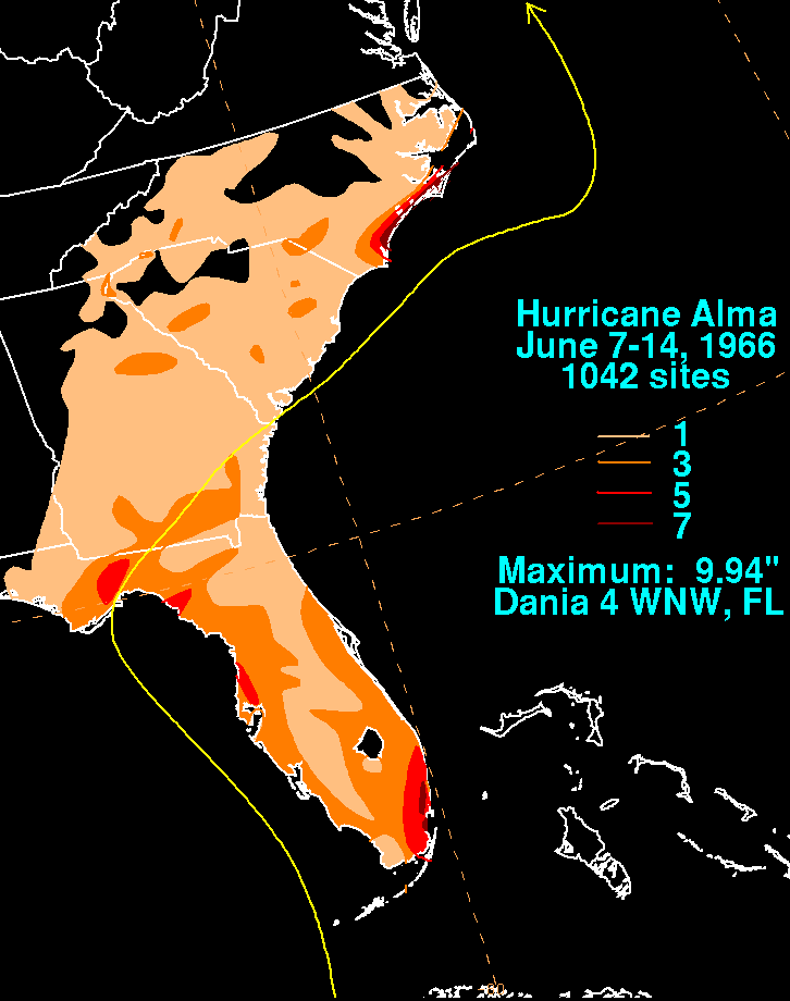
Alma caused strong wind damage and flooding, mainly across Florida. The heaviest rainfall was confined to the Gold coast of Florida and coastal North Carolina
. The highest rainfall report was just under 10 inches (254 mm) near Dania, Florida. There was significant loss to the mango crop in southwest Florida and the grapefruit crop in Pinellas county. Wind damage from Alma caused damage to the tobacco crop in northern Florida. A 10 feet (3 m) storm tide was recorded near New Port Richey, Crystal River, and Cedar Key. Much of Cedar Key went underwater during the hurricane. Damage amounted to $10 million and 6 deaths in Florida. Five tornadoes were spawned by the cyclone. A flow of moisture from Alma into a frontal over the northern Mid-Atlantic states led to 2–3 in (50.8–76.2 mm) of rain across southern New York.
In all, Hurricane Alma caused over $210.1 million in damage (1966 USD), with 90 deaths related to the storm.
of 1951
. It became the third strongest June hurricane on record, behind Hurricane Audrey
in 1957
and Hurricane Alex in 2010
.
1966 Atlantic hurricane season
The 1966 Atlantic hurricane season officially began on June 1, 1966, and lasted until November 30, 1966. These dates conventionally delimit the period of each year when most tropical cyclones form in the Atlantic basin. The 1966 season was near normal with eleven tropical storms...
. It was the earliest continental U.S. hurricane strike within any season since 1908. It brought moderate rains to the Southeast, and wind damage was mainly confined to Florida
Florida
Florida is a state in the southeastern United States, located on the nation's Atlantic and Gulf coasts. It is bordered to the west by the Gulf of Mexico, to the north by Alabama and Georgia and to the east by the Atlantic Ocean. With a population of 18,801,310 as measured by the 2010 census, it...
.
Meteorological history
In early June, a trough in the westerlies extended from the southeastern United States towards NicaraguaNicaragua
Nicaragua is the largest country in the Central American American isthmus, bordered by Honduras to the north and Costa Rica to the south. The country is situated between 11 and 14 degrees north of the Equator in the Northern Hemisphere, which places it entirely within the tropics. The Pacific Ocean...
. A surface circulation formed near Cabo Gracias a Dios
Cabo Gracias a Dios
Cabo Gracias a Dios is a cape located in the middle of the east coast of Central America, within what is variously called the Mosquito Coast and La Mosquitia...
, also known as Cape Gracias, on June 3, and drifted southwestward over land. The circulation organized into Tropical Depression One early on June 4 over the Honduras
Honduras
Honduras is a republic in Central America. It was previously known as Spanish Honduras to differentiate it from British Honduras, which became the modern-day state of Belize...
/Nicaragua border, where it turned to a north drift, dropping heavy rain across the countries.
Upon reaching the Caribbean Sea
Caribbean Sea
The Caribbean Sea is a sea of the Atlantic Ocean located in the tropics of the Western hemisphere. It is bounded by Mexico and Central America to the west and southwest, to the north by the Greater Antilles, and to the east by the Lesser Antilles....
on June 5, the depression was able to strengthen, with warm water temperatures, good outflow, and deep convection. When the only inhibiting factor, land, was removed, the depression rapidly intensified, becoming Tropical Storm Alma on June 6 and reaching hurricane status that night. Initially a slow mover, Alma accelerated to the northeast, where it reached winds of 95 mi/h before hitting the Isle of Youth
Isle of Youth
Isla de la Juventud is the second-largest Cuban island and the seventh-largest island in the West Indies . The island has an area and is 100 km south of the island of Cuba, across the Gulf of Batabanó...
on June 8.
Just six hours after crossing the Isle of Youth, Alma hit western Cuba
Cuba
The Republic of Cuba is an island nation in the Caribbean. The nation of Cuba consists of the main island of Cuba, the Isla de la Juventud, and several archipelagos. Havana is the largest city in Cuba and the country's capital. Santiago de Cuba is the second largest city...
. Because it crossed at one of the narrowest points of the island, the hurricane didn't weaken at all. On the contrary, upon reaching the Gulf of Mexico
Gulf of Mexico
The Gulf of Mexico is a partially landlocked ocean basin largely surrounded by the North American continent and the island of Cuba. It is bounded on the northeast, north and northwest by the Gulf Coast of the United States, on the southwest and south by Mexico, and on the southeast by Cuba. In...
, Alma reached major hurricane status with peak winds of 130 mi/h late on June 8. It passed between the Dry Tortugas
Dry Tortugas
The Dry Tortugas are a small group of islands, located at the end of the Florida Keys, USA, about west of Key West, and west of the Marquesas Keys, the closest islands. Still further west is the Tortugas Bank, which is completely submerged. The first Europeans to discover the islands were the...
and Key West, Florida
Key West, Florida
Key West is a city in Monroe County, Florida, United States. The city encompasses the island of Key West, the part of Stock Island north of U.S. 1 , Sigsbee Park , Fleming Key , and Sunset Key...
at that intensity, and began a north-northwest motion in response to an upper level cyclone developing over the extreme northern Gulf of Mexico.
After crossing the Florida west coast, Alma weakened quickly, and hit Apalachee Bay
Apalachee Bay
Apalachee Bay is a bay in the northeastern Gulf of Mexico occupying an indentation of the Florida coast to the west of where the Florida peninsula joins the United States mainland. It is bordered by Taylor, Jefferson, Wakulla and Franklin counties. The Aucilla, Econfina, St. Marks and Ochlocknee...
on June 9 as a 90 mi/h hurricane. The storm turned to the northeast, where it weakened to a 45 mi/h tropical storm while crossing Georgia
Georgia (U.S. state)
Georgia is a state located in the southeastern United States. It was established in 1732, the last of the original Thirteen Colonies. The state is named after King George II of Great Britain. Georgia was the fourth state to ratify the United States Constitution, on January 2, 1788...
. On June 11 Alma emerged into the Atlantic near Savannah, Georgia
Savannah, Georgia
Savannah is the largest city and the county seat of Chatham County, in the U.S. state of Georgia. Established in 1733, the city of Savannah was the colonial capital of the Province of Georgia and later the first state capital of Georgia. Today Savannah is an industrial center and an important...
, and continued its northeast movement. While paralleling the Carolina coastline over the Gulf Stream, Alma briefly restrengthened into a hurricane on the night of the 11th. This intensification trend ended when cold waters and dry air approached the system, causing Alma to lose its tropical characteristics on June 13 while east of the Delmarva Peninsula
Delmarva Peninsula
The Delmarva Peninsula is a large peninsula on the East Coast of the United States, occupied by most of Delaware and portions of Maryland and Virginia...
. As an extratropical storm, Alma lasted another day before dissipating near Cape Cod
Cape Cod
Cape Cod, often referred to locally as simply the Cape, is a cape in the easternmost portion of the state of Massachusetts, in the Northeastern United States...
.
Preparations
One week before its hurricane preparations for the season, Alma gave the Kennedy Space CenterKennedy Space Center
The John F. Kennedy Space Center is the NASA installation that has been the launch site for every United States human space flight since 1968. Although such flights are currently on hiatus, KSC continues to manage and operate unmanned rocket launch facilities for America's civilian space program...
a chance to go through the situation under the threat of a real storm. A mock-up of a Saturn V
Saturn V
The Saturn V was an American human-rated expendable rocket used by NASA's Apollo and Skylab programs from 1967 until 1973. A multistage liquid-fueled launch vehicle, NASA launched 13 Saturn Vs from the Kennedy Space Center, Florida with no loss of crew or payload...
rocket was rolled back to the Vehicle Assembly Building
Vehicle Assembly Building
The Vehicle Assembly Building, or VAB, at NASA's Kennedy Space Center was used to assemble and house American manned launch vehicles from 1968-2011. It is the fourth largest building in the world by volume...
on June 8, within 12 hours in the face of 60 mi/h wind gusts, within the anticipated time for such a move. Two other rockets were also removed from their pads.
Impact
Central America
Central America is the central geographic region of the Americas. It is the southernmost, isthmian portion of the North American continent, which connects with South America on the southeast. When considered part of the unified continental model, it is considered a subcontinent...
as a tropical depression, Alma dropped torrential rains, resulting in 30 inches (762 mm) of rain in some locations. The Honduran town of San Rafael
San Rafael, Lempira
San Rafael is a municipality in the Honduran department of Lempira.San Rafael is one of the farthest municipalities of the Lempira department of Honduras...
was nearly destroyed, killing 73 of the town's population. In Cuba, the storm brought heavy flooding, causing nearly $200 million in damage and 11 deaths.
During its transit of the Gulf of Mexico, scientists were measuring the hurricane's impact of the seawater temperatures around Alma at a depth of 4 meters. They discovered that they cooled off in its southeast quadrant due to the storm's wake. In the southwest Atlantic ocean, the vessel Atlantis II sailed through the eye of Alma, and learned information regarding air-sea interaction in the vicinity of a tropical cyclone.
Alma caused strong wind damage and flooding, mainly across Florida. The heaviest rainfall was confined to the Gold coast of Florida and coastal North Carolina
North Carolina
North Carolina is a state located in the southeastern United States. The state borders South Carolina and Georgia to the south, Tennessee to the west and Virginia to the north. North Carolina contains 100 counties. Its capital is Raleigh, and its largest city is Charlotte...
. The highest rainfall report was just under 10 inches (254 mm) near Dania, Florida. There was significant loss to the mango crop in southwest Florida and the grapefruit crop in Pinellas county. Wind damage from Alma caused damage to the tobacco crop in northern Florida. A 10 feet (3 m) storm tide was recorded near New Port Richey, Crystal River, and Cedar Key. Much of Cedar Key went underwater during the hurricane. Damage amounted to $10 million and 6 deaths in Florida. Five tornadoes were spawned by the cyclone. A flow of moisture from Alma into a frontal over the northern Mid-Atlantic states led to 2–3 in (50.8–76.2 mm) of rain across southern New York.
In all, Hurricane Alma caused over $210.1 million in damage (1966 USD), with 90 deaths related to the storm.
| Country | Deaths |
|---|---|
| Honduras | 73 |
| Cuba | 11 |
| United States United States The United States of America is a federal constitutional republic comprising fifty states and a federal district... |
6 |
| Total | 90 |
Records
When Hurricane Alma hit Florida on June 9, it became the earliest hurricane strike on the United States since a hurricane in May of 1908. The hurricane was also the second earliest to attain major hurricane intensity, only behind Hurricane AbleHurricane Able (1951)
Hurricane Able was the strongest recorded hurricane outside of the typical Atlantic hurricane season. The first tropical cyclone in 1951, Able developed from a trough of low pressure on May 15 about 300 miles south of Bermuda...
of 1951
1951 Atlantic hurricane season
The 1951 Atlantic hurricane season was moderately active, starting with an pre-season hurricane and lasting until late October. The season officially started on June 15, when the United States Weather Bureau began its daily monitoring for tropical cyclone activity; the season officially ended...
. It became the third strongest June hurricane on record, behind Hurricane Audrey
Hurricane Audrey
Hurricane Audrey was the first major hurricane of the 1957 Atlantic hurricane season. Audrey was the only storm to reach Category 4 status in June. A powerful hurricane, Audrey caused catastrophic damage across eastern Texas and western Louisiana. It then affected the South Central United States as...
in 1957
1957 Atlantic hurricane season
The 1957 Atlantic hurricane season officially began on June 15, 1957, and lasted until November 15, 1957. These dates conventionally delimit the period of each year when most tropical cyclones form in the Atlantic basin. The season was below average, with eight total storms and just three...
and Hurricane Alex in 2010
2010 Atlantic hurricane season
The 2010 Atlantic hurricane season was the third most active Atlantic hurricane season on record, tying with the 1887 Atlantic hurricane season, 1995 Atlantic hurricane season and the 2011 Atlantic hurricane season. It had the most number of named storms since the 2005 season and also ties with the...
.
See also
- List of Atlantic hurricanes
- List of Florida hurricanes (1950-1974)