
Hurricane Gracie
Encyclopedia
Hurricane Gracie was a major hurricane that formed in September 1959, the strongest during the 1959 Atlantic hurricane season
and the most intense to strike the United States
since Hurricane Hazel
in 1954. The system was first noted as an area of thunderstorms east of the Lesser Antilles
which moved just north of the Greater Antilles
, quickly intensifying into a hurricane on September 22. Gracie was a storm that was very difficult to forecast, with its movement unpredictable. After five days of erratic motion, Gracie became a major hurricane which struck South Carolina
, and weakened as it moved up the Appalachians, bringing much needed rain to a drought-plagued region. Much of the destruction related with Gracie was centered on Beaufort, South Carolina
. Gracie became an extratropical cyclone
on September 30 while moving through the Eastern United States.
y weather was first noted a few hundred miles east of the Lesser Antilles on September 18. The convective area organized into a tropical depression near the north coast of Hispaniola
on September 20. After moving west-northwestward for a day, it turned northeastward, where upper level winds were very favorable and steering currents were very weak. On September 22 Gracie was named as a tropical depression before it developed into Tropical Storm Gracie, followed by reaching hurricane strength later that night. It turned to the east on September 25, and turned back west to west-northwest on September 27 as a stable anticyclone built in to its north.
Gracie quickly strengthened and reached its peak of 140 mph (225.3 km/h) winds on September 29, but cooler air and land interaction weakened it to a 120 mph (193.1 km/h) Category 3 major hurricane at the time of its landfall at 1625 UTC
over St. Helena Sound
near the south end of Edisto Island
in South Carolina
. After landfall, Gracie moved inland and north and became extratropical on September 30.
to Wilmington, North Carolina
at 1600 UTC on September 28, which were quickly updated to hurricane warnings by 1900 UTC the same day. By 1900 UTC, gale warnings were in effect from Daytona Beach, Florida
to Savannah, Georgia as well as from Wilmington to Morehead City, North Carolina
. At 1200 UTC on September 29, gale warnings were dropped south of Brunswick, Georgia
. At 2200 UTC, gale warnings were extended northward to Cape May, New Jersey
, including Chesapeake Bay
and Delaware Bay
. At 0400 UTC on September 30, all warnings south of Cape Hatteras were dropped, leaving gale warnings in effect from Cape Hatteras northward. At 1000 UTC, small craft were advised to remain in port from Cape May northward to Block Island, Rhode Island. By 1600 UTC, due to Gracie's continued weakening, all remaining gale warnings were downgraded to small craft warnings.
 Storm surge flooding was minimal due to the storm's landfall near the time of low tide
. However, Charleston still recorded their highest tide since 1940. Along the coast of southern South Carolina, the storm tide was measured up to 11.9 feet (3.6 m) above mean lower low water (the average level of the lowest low tide each day). The United States Coast Guard
vessel Bramble evacuated people stranded in Savannah and Charleston on September 30. Gracie killed 10 people in South Carolina
and Georgia
, mainly due to wind and rain-induced automobile accidents, falling trees and electrocution by live wires. The Garden Club of South Carolina replaced numerous trees after the storm. Wind damage was quite significant across South Carolina
, particularly the city of Beaufort, South Carolina, with many downed trees, telephone poles, and streetlights. Also, numerous windows were shattered and shingles were torn off of roofs. A number of creeks overflowed causing floodwaters that, in areas, were several feet deep. The opening of the Beaufort Center of the University of South Carolina
was delayed due to Gracie. It would be 30 years before another major hurricane struck South Carolina; Hurricane Hugo
in September 1989.
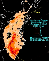
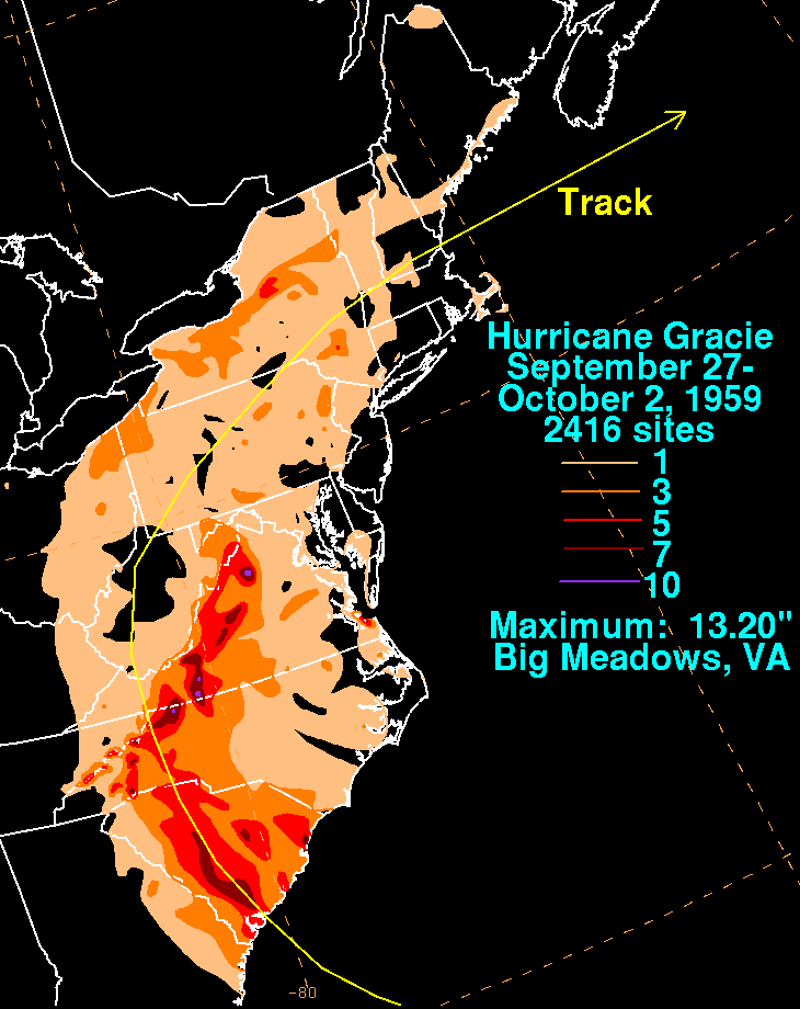
. The highest rainfall amount measured during the storm was 13.2 inches (335.3 mm) at Big Meadows. The storm spawned seven tornadoes in all. A few of the tornado
es which accompanied the dissipating storm through Virginia
killed twelve people near Charlottesville, Virginia
. Other tornadoes touched down in the Carolinas and Pennsylvania. For the most part, rainfall from Gracie was beneficial as it moved up the Appalachians since the area had been in a drought preceding the cyclone
.
was changed forever by Gracie, due to human efforts to renourish the beach
after its passage. Most of the shell hash beach currently at Edisto was placed there after Gracie. In order to expand the beach, an inland marsh
was excavated and moved to the shoreline. This created highly desirable beach front property which led to new development along the coast seaward of Palmetto Boulevard, but also created an environmental catastrophe along the nearby ocean floor. A species of isopod which grows in coastal estuaries, the Cyathura Polita, disappeared after the passage of this hurricane from the Ashepoo River
in South Carolina. The Kermadec Petrel
, a bird, was swept to Lookout Mountain Sanctuary in Pennsylvania
during Gracie, marking the first time it appeared in North America.
1959 Atlantic hurricane season
The 1959 Atlantic hurricane season officially began on June 15, 1959, and lasted until November 15, 1959. These dates conventionally delimit the period of each year when most tropical cyclones form in the Atlantic basin...
and the most intense to strike the United States
United States
The United States of America is a federal constitutional republic comprising fifty states and a federal district...
since Hurricane Hazel
Hurricane Hazel
Hurricane Hazel was the deadliest and costliest hurricane of the 1954 Atlantic hurricane season. The storm killed as many as 1,000 people in Haiti before striking the United States near the border between North and South Carolina, as a Category 4 hurricane...
in 1954. The system was first noted as an area of thunderstorms east of the Lesser Antilles
Lesser Antilles
The Lesser Antilles are a long, partly volcanic island arc in the Western Hemisphere. Most of its islands form the eastern boundary of the Caribbean Sea with the Atlantic Ocean, with the remainder located in the southern Caribbean just north of South America...
which moved just north of the Greater Antilles
Greater Antilles
The Greater Antilles are one of three island groups in the Caribbean. Comprising Cuba, Jamaica, Hispaniola , and Puerto Rico, the Greater Antilles constitute almost 90% of the land mass of the entire West Indies.-Greater Antilles in context :The islands of the Caribbean Sea, collectively known as...
, quickly intensifying into a hurricane on September 22. Gracie was a storm that was very difficult to forecast, with its movement unpredictable. After five days of erratic motion, Gracie became a major hurricane which struck South Carolina
South Carolina
South Carolina is a state in the Deep South of the United States that borders Georgia to the south, North Carolina to the north, and the Atlantic Ocean to the east. Originally part of the Province of Carolina, the Province of South Carolina was one of the 13 colonies that declared independence...
, and weakened as it moved up the Appalachians, bringing much needed rain to a drought-plagued region. Much of the destruction related with Gracie was centered on Beaufort, South Carolina
Beaufort, South Carolina
Beaufort is a city in and the county seat of Beaufort County, South Carolina, United States. Chartered in 1711, it is the second-oldest city in South Carolina, behind Charleston. The city's population was 12,361 in the 2010 census. It is located in the Hilton Head Island-Beaufort Micropolitan...
. Gracie became an extratropical cyclone
Extratropical cyclone
Extratropical cyclones, sometimes called mid-latitude cyclones or wave cyclones, are a group of cyclones defined as synoptic scale low pressure weather systems that occur in the middle latitudes of the Earth having neither tropical nor polar characteristics, and are connected with fronts and...
on September 30 while moving through the Eastern United States.
Meteorological history
An area of squallSquall
A squall is a sudden, sharp increase in wind speed which is usually associated with active weather, such as rain showers, thunderstorms, or heavy snow. Squalls refer to an increase in the sustained winds over a short time interval, as there may be higher gusts during a squall event...
y weather was first noted a few hundred miles east of the Lesser Antilles on September 18. The convective area organized into a tropical depression near the north coast of Hispaniola
Hispaniola
Hispaniola is a major island in the Caribbean, containing the two sovereign states of the Dominican Republic and Haiti. The island is located between the islands of Cuba to the west and Puerto Rico to the east, within the hurricane belt...
on September 20. After moving west-northwestward for a day, it turned northeastward, where upper level winds were very favorable and steering currents were very weak. On September 22 Gracie was named as a tropical depression before it developed into Tropical Storm Gracie, followed by reaching hurricane strength later that night. It turned to the east on September 25, and turned back west to west-northwest on September 27 as a stable anticyclone built in to its north.
Gracie quickly strengthened and reached its peak of 140 mph (225.3 km/h) winds on September 29, but cooler air and land interaction weakened it to a 120 mph (193.1 km/h) Category 3 major hurricane at the time of its landfall at 1625 UTC
Coordinated Universal Time
Coordinated Universal Time is the primary time standard by which the world regulates clocks and time. It is one of several closely related successors to Greenwich Mean Time. Computer servers, online services and other entities that rely on having a universally accepted time use UTC for that purpose...
over St. Helena Sound
Saint Helena Sound
Saint Helena Sound is a coastal inlet in Beaufort and Colleton counties, South Carolina. The inlet is located East of Beaufort, between Edisto Island. and Hunting Island. Saint Helena Sound is 7.5 mi/12.1 km wide. The Combahee River empties from the Northwest and the Edisto River and...
near the south end of Edisto Island
Edisto, South Carolina
Edisto Island is one of South Carolina's Sea Islands, the larger part of which lies in Charleston County, with its southern tip in Colleton County. The Charleston County part is a census-designated place. The population was 2,301 at the 2000 census...
in South Carolina
South Carolina
South Carolina is a state in the Deep South of the United States that borders Georgia to the south, North Carolina to the north, and the Atlantic Ocean to the east. Originally part of the Province of Carolina, the Province of South Carolina was one of the 13 colonies that declared independence...
. After landfall, Gracie moved inland and north and became extratropical on September 30.
Preparations
A hurricane watch was issued for the coast of the United States from Savannah, GeorgiaSavannah, Georgia
Savannah is the largest city and the county seat of Chatham County, in the U.S. state of Georgia. Established in 1733, the city of Savannah was the colonial capital of the Province of Georgia and later the first state capital of Georgia. Today Savannah is an industrial center and an important...
to Wilmington, North Carolina
Wilmington, North Carolina
Wilmington is a port city in and is the county seat of New Hanover County, North Carolina, United States. The population is 106,476 according to the 2010 Census, making it the eighth most populous city in the state of North Carolina...
at 1600 UTC on September 28, which were quickly updated to hurricane warnings by 1900 UTC the same day. By 1900 UTC, gale warnings were in effect from Daytona Beach, Florida
Daytona Beach, Florida
Daytona Beach is a city in Volusia County, Florida, USA. According to 2008 U.S. Census Bureau estimates, the city has a population of 64,211. Daytona Beach is a principal city of the Deltona – Daytona Beach – Ormond Beach, Florida Metropolitan Statistical Area, which the census bureau estimated had...
to Savannah, Georgia as well as from Wilmington to Morehead City, North Carolina
Morehead City, North Carolina
Morehead City is a port city in Carteret County, North Carolina, United States. The population was 8,661 at the 2010 census. Morehead City celebrated the 150th anniversary of its founding on May 5, 2007...
. At 1200 UTC on September 29, gale warnings were dropped south of Brunswick, Georgia
Brunswick, Georgia
Brunswick is the major urban and economic center in southeastern Georgia in the United States. The municipality is located on a harbor near the Atlantic Ocean, approximately 30 miles north of Florida and 70 miles south of South Carolina. Brunswick is bordered on the east by the Atlantic...
. At 2200 UTC, gale warnings were extended northward to Cape May, New Jersey
Cape May, New Jersey
Cape May is a city at the southern tip of Cape May Peninsula in Cape May County, New Jersey, where the Delaware Bay meets the Atlantic Ocean and is one of the country's oldest vacation resort destinations. It is part of the Ocean City Metropolitan Statistical Area. As of the 2010 United States...
, including Chesapeake Bay
Chesapeake Bay
The Chesapeake Bay is the largest estuary in the United States. It lies off the Atlantic Ocean, surrounded by Maryland and Virginia. The Chesapeake Bay's drainage basin covers in the District of Columbia and parts of six states: New York, Pennsylvania, Delaware, Maryland, Virginia, and West...
and Delaware Bay
Delaware Bay
Delaware Bay is a major estuary outlet of the Delaware River on the Northeast seaboard of the United States whose fresh water mixes for many miles with the waters of the Atlantic Ocean. It is in area. The bay is bordered by the State of New Jersey and the State of Delaware...
. At 0400 UTC on September 30, all warnings south of Cape Hatteras were dropped, leaving gale warnings in effect from Cape Hatteras northward. At 1000 UTC, small craft were advised to remain in port from Cape May northward to Block Island, Rhode Island. By 1600 UTC, due to Gracie's continued weakening, all remaining gale warnings were downgraded to small craft warnings.
Georgia and South Carolina
Tide
Tides are the rise and fall of sea levels caused by the combined effects of the gravitational forces exerted by the moon and the sun and the rotation of the Earth....
. However, Charleston still recorded their highest tide since 1940. Along the coast of southern South Carolina, the storm tide was measured up to 11.9 feet (3.6 m) above mean lower low water (the average level of the lowest low tide each day). The United States Coast Guard
United States Coast Guard
The United States Coast Guard is a branch of the United States Armed Forces and one of the seven U.S. uniformed services. The Coast Guard is a maritime, military, multi-mission service unique among the military branches for having a maritime law enforcement mission and a federal regulatory agency...
vessel Bramble evacuated people stranded in Savannah and Charleston on September 30. Gracie killed 10 people in South Carolina
South Carolina
South Carolina is a state in the Deep South of the United States that borders Georgia to the south, North Carolina to the north, and the Atlantic Ocean to the east. Originally part of the Province of Carolina, the Province of South Carolina was one of the 13 colonies that declared independence...
and Georgia
Georgia (U.S. state)
Georgia is a state located in the southeastern United States. It was established in 1732, the last of the original Thirteen Colonies. The state is named after King George II of Great Britain. Georgia was the fourth state to ratify the United States Constitution, on January 2, 1788...
, mainly due to wind and rain-induced automobile accidents, falling trees and electrocution by live wires. The Garden Club of South Carolina replaced numerous trees after the storm. Wind damage was quite significant across South Carolina
South Carolina
South Carolina is a state in the Deep South of the United States that borders Georgia to the south, North Carolina to the north, and the Atlantic Ocean to the east. Originally part of the Province of Carolina, the Province of South Carolina was one of the 13 colonies that declared independence...
, particularly the city of Beaufort, South Carolina, with many downed trees, telephone poles, and streetlights. Also, numerous windows were shattered and shingles were torn off of roofs. A number of creeks overflowed causing floodwaters that, in areas, were several feet deep. The opening of the Beaufort Center of the University of South Carolina
University of South Carolina
The University of South Carolina is a public, co-educational research university located in Columbia, South Carolina, United States, with 7 surrounding satellite campuses. Its historic campus covers over in downtown Columbia not far from the South Carolina State House...
was delayed due to Gracie. It would be 30 years before another major hurricane struck South Carolina; Hurricane Hugo
Hurricane Hugo
Hurricane Hugo was a classical, destructive and rare Cape Verde-type hurricane which struck the Caribbean islands of Guadeloupe, Montserrat, St. Croix, Puerto Rico and the USA mainland in South Carolina as a Category 4 hurricane during September of the 1989 Atlantic hurricane season...
in September 1989.
Elsewhere in the United States
Heavy rains fell well ahead of the storm along an inverted trough extending north of the storm, causing 6.79 inches (172.5 mm) between the mornings of September 28 and September 29 at Norfolk, VirginiaNorfolk, Virginia
Norfolk is an independent city in the Commonwealth of Virginia in the United States. With a population of 242,803 as of the 2010 Census, it is Virginia's second-largest city behind neighboring Virginia Beach....
. The highest rainfall amount measured during the storm was 13.2 inches (335.3 mm) at Big Meadows. The storm spawned seven tornadoes in all. A few of the tornado
Tornado
A tornado is a violent, dangerous, rotating column of air that is in contact with both the surface of the earth and a cumulonimbus cloud or, in rare cases, the base of a cumulus cloud. They are often referred to as a twister or a cyclone, although the word cyclone is used in meteorology in a wider...
es which accompanied the dissipating storm through Virginia
Virginia
The Commonwealth of Virginia , is a U.S. state on the Atlantic Coast of the Southern United States. Virginia is nicknamed the "Old Dominion" and sometimes the "Mother of Presidents" after the eight U.S. presidents born there...
killed twelve people near Charlottesville, Virginia
Charlottesville, Virginia
Charlottesville is an independent city geographically surrounded by but separate from Albemarle County in the Commonwealth of Virginia, United States, and named after Charlotte of Mecklenburg-Strelitz, the queen consort of King George III of the United Kingdom.The official population estimate for...
. Other tornadoes touched down in the Carolinas and Pennsylvania. For the most part, rainfall from Gracie was beneficial as it moved up the Appalachians since the area had been in a drought preceding the cyclone
Cyclone
In meteorology, a cyclone is an area of closed, circular fluid motion rotating in the same direction as the Earth. This is usually characterized by inward spiraling winds that rotate anticlockwise in the Northern Hemisphere and clockwise in the Southern Hemisphere of the Earth. Most large-scale...
.
Long term impact
Edisto Beach, South CarolinaEdisto Beach, South Carolina
Edisto Beach is a town in Colleton County, South Carolina, United States. The population was 641 at the 2000 census. The town limits include only the coastal area of Edisto Island .-History:Edisto Beach was originally settled by the Edisto Indians and was discovered...
was changed forever by Gracie, due to human efforts to renourish the beach
Beach
A beach is a geological landform along the shoreline of an ocean, sea, lake or river. It usually consists of loose particles which are often composed of rock, such as sand, gravel, shingle, pebbles or cobblestones...
after its passage. Most of the shell hash beach currently at Edisto was placed there after Gracie. In order to expand the beach, an inland marsh
Marsh
In geography, a marsh, or morass, is a type of wetland that is subject to frequent or continuous flood. Typically the water is shallow and features grasses, rushes, reeds, typhas, sedges, other herbaceous plants, and moss....
was excavated and moved to the shoreline. This created highly desirable beach front property which led to new development along the coast seaward of Palmetto Boulevard, but also created an environmental catastrophe along the nearby ocean floor. A species of isopod which grows in coastal estuaries, the Cyathura Polita, disappeared after the passage of this hurricane from the Ashepoo River
Ashepoo River
Ashepoo River is a short blackwater river in South Carolina. It rises in a confluence of swamps south of Walterboro, flows in southeast direction and then empties into Saint Helena Sound at . The entire course of the river lies within the boundaries of Colleton County...
in South Carolina. The Kermadec Petrel
Kermadec Petrel
The Kermadec Petrel is a species of seabird in the Procellariidae family.-Distribution:It is found in Australia, Chile, Japan, Mexico, Micronesia, New Zealand, Norfolk Island, Pitcairn, and the United States....
, a bird, was swept to Lookout Mountain Sanctuary in Pennsylvania
Pennsylvania
The Commonwealth of Pennsylvania is a U.S. state that is located in the Northeastern and Mid-Atlantic regions of the United States. The state borders Delaware and Maryland to the south, West Virginia to the southwest, Ohio to the west, New York and Ontario, Canada, to the north, and New Jersey to...
during Gracie, marking the first time it appeared in North America.
Retirement
Gracie's retirement status is unclear; some sources list it as being retired, although the official NHC list omits Gracie. However, the name has not been used since; Hurricane Gracie was before the formal lists were created, so it was not replaced with any particular name.See also
- List of Atlantic hurricanes
- List of tropical cyclones