
Lake Lanier
Encyclopedia
Lake Lanier is a reservoir
in the northern portion of the U.S. state
of Georgia
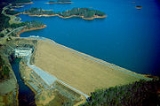
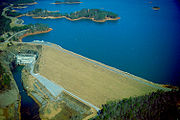
. It was created by the completion of Buford Dam on the Chattahoochee River
in 1956, and is also fed by the waters of the Chestatee River
. The lake encompasses 38000 acres (153.8 km²) of water, and 692 miles (1,113.7 km) of shore
line at normal level, a "full summer pool" of 1071 feet (326.4 m) above mean sea level
. It was named for poet
Sidney Lanier
, and was built and is operated by the U.S. Army Corps of Engineers. It is patrol
led by the Georgia Department of Natural Resources
(GDNR).
, Forsyth
, Dawson
, Gwinnett
, and Lumpkin
counties, split about 60%, 30%, 5%, 4%, and 1% respectively, filling the valley
into numerous small arms and fingers. The former thalweg
of the Chestatee and the Chattahoochee south of it form the county line
between Hall and a tiny corner of Gwinnett to the east, and Dawson and Forsyth to the west.
One of the main purposes of the lake is flood control
downstream of the lake, mainly protecting metro Atlanta
. There have only been two major flood
ing events on the downstream section since the construction of Buford Dam. The most recent flooding event was in 2009.
The $1 billion project was approved, ground breaking was in 1950 and more than $2 million had been spent by the Corps on preliminary construction when the House Committee on Appropriations
refused to provide more funds in June 1951. During that summer Atlanta mayor William Hartsfield traveled to Washington numerous times pressing Senators Richard Russell, Jr.
and Walter F. George
to restore funding to ensure Atlanta's water supply during droughts. Hartsfield was back in Washington in 1955 for $11 million more for the dam, which had a target date of 1956, again stressing the importance of an adequate water supply for the city. Again, funds were forthcoming and the dam opened on schedule.
Lake Lanier began filling in 1956, and in 1957, 20 miles downstream, Morgan Falls Dam
was raised to regulate the flow from Buford Dam to give Atlanta water during the hours it was needed most. The foresight of the entire project was confirmed in early fall of 1958 during two solid months of drought which would have left the Chattahoochee and its tributaries nearly dry, if not for the Buford Dam.
Since the 1990s, the Corps of Engineers, Florida, Georgia, and Alabama have all been fighting for use of the water held in Lake Lanier. Federal law mandates that when a river flows between two or more states, each state has a right to an equal share of the water. Additionally, other laws such as the Endangered Species Act require that water be available for threatened or endangered species that live in or around Chattahoochee River and Apalachicola Bay
.
 In June 2006, the USACE revealed that the new lake gauge
at the dam, replaced in December 2005, was not properly calibrated, yielding a lake level reading nearly two feet (over half a meter) higher than the actual level. Because of this, nearly twenty-two billion U.S gallons (over eighty-two billion liters) of excess water was released over and above the already planned excess releases to support both the successful spawning of gulf sturgeon in the Apalachicola River
and to protect several species of mussel
s in Apalachicola Bay
from excessive saltwater
intrusion
.
Georgia Governor Sonny Perdue
said that the Corps had created a "manmade drought
", because most of the state is already experiencing dry conditions. This came at a time when outdoor water-use restriction
s were already being put in place by local government
s, because of enormous water use on the many lawn
s which have replaced the forests in newer suburb
an areas. Mainly because of this incident at the lake, the state then declared a drought and enacted a ban on outdoor water use from 10AM to 4PM, in addition to the permanent weekly odd/even address system. Other local counties have imposed further restrictions or even total bans, based on each water system's conditions. Outdoor watering has since been banned completely as the state has fallen under the worst drought in its recorded history.
On October 16, 2007, Governor Perdue gave the USACE until the evening of October 17 to come up with a plan for the continued release of water for Florida wildlife. Senator Johnny Isakson stood before the Georgia General Assembly saying, "The health, safety and welfare of people are threatened. They are threatened by an act this Congress passed that had no intention to threaten them." He eventually withdrew his threat to sue the Corps of Engineers, but the Lake Lanier Association indicated that it will attempt a private legal action. Governor Perdue's attempts to reach an agreement with Florida over water releases fell through, leaving a final decision on releases from the lake in the hands of the U.S. Fish and Wildlife Service.
On November 22, 2007 the water level was at 1052.34 feet (320.8 m) http://www.srh.noaa.gov/ffc/html/rrm.php, setting a new record low (see below: Lake water levels & External links). The previous low was 1052.7 ft (320.9 m), set in December 1981 http://lanier.sam.usace.army.mil/faqs.htm. The water level as of November 28, 2007 had dropped below the newly set record to 1051.98 feet (320.6 m) and still decreasing at 0.05 ft (15.2 mm) a dayhttp://www.srh.noaa.gov/ffc/html/rrm.php. One month later, the water level stabilized around a final low of 1050.79 ft (320.3 m), recorded December 26, 2007 at Buford Dam, with the level rising or falling daily by about 0.03 ft (9.1 mm), although a foot lower than November levels.
The day after Christmas, the water level began rising from week to week.
Eventually, on February 18, 2008, the water level of Lake Lanier rose back, above the record-low levels set in November, rising to 1052.8 ft (320.89 m), even higher than the December 1981 level of 1052.7 ft (320.9 m), effectively ending the record-low phase of the drought crisis.
A similar drought situation also occurred in late 2008. At the end of the year, the water level stabilized around a final low of 1051 ft (320.3 m), recorded December 8, 2008 at Buford Dam. That level was only slightly above the 2007 low of 1050.79 ft (320.3 m) from December 26, 2007.
However, after rainfall during the winter of 2008-2009, on March 30, 2009, the climatologist of the state of Georgia, David Stooksbury, declared the drought over, noting, "soil moisture is near normal, stream flows are near normal. Small and medium-sized reservoirs are full." Stooksbury continued by noting, "There is still the 500-pound gorilla sitting in the room and that’s Lanier." In May 2009, the water level of Lake Lanier rose to exceed 1066 ft, reaching a high of 1066.71 ft (325.1 m) in mid-June 2009. Yet it did not reach the full summer pool of 1071 ft during mid-2009, remaining over 4 ft (1.2 m) lower. Regardless, the concerns about the health of the lake and Atlanta's water supply were in full retreat. Due to weeks of heavy rains and flooding in North Georgia, Lake Lanier reached full pool in mid-October 2009. The record high is 1077.2 feet (328.3 m) set in April 1964.
The record-low lake levels had revealed parts of the lake bottom not seen since the 1950s, when approximately 700 families were moved from the area to create the lake. An abandoned stretch of Georgia Highway 53 ran along one edge of new shoreline, and concrete foundations from homes and part of what was once the Gainesville's Looper Speedway were uncovered. More recent additions to the lake - including discarded trash, boat batteries and even sunken boats - were discovered, and local efforts to clean up the lake bottom were organized. Several automobiles, some stolen, and discarded firearms were also recovered by law enforcement officials.http://www.jacksonville.com/apnews/stories/122207/D8TMLUFO2.shtml
(chosen as an arbiter from a neutral location) ruled that Congress never authorized Lake Lanier to be used as a source of the water supply
for metro Atlanta
. The state was given three years to stop withdrawing from the lake (except for the adjacent cities of Gainesville
and Buford
), unless Congress authorizes it, or the three states which use the basin come to an agreement. The Atlanta Regional Commission
chairman noted that if enforced, cutting drinking water
to 75% of the region would require disaster aid from the Federal Emergency Management Agency
(FEMA).
See also Tri-state water dispute
.
 The lake is popular with boater
s, houseboat
s, jetskiers and others, particularly around the summer holiday
s. Over 7.5 million people per year visit the lake, including its marina
s and the Lake Lanier Islands
waterpark. The rowing
and sprint canoeing
events during the 1996 Summer Olympics
were held at the lake. It also hosted the canoe sprint World Championships in 2003
at the Lanier Canoe and Kayak Club.
One resort
hotel sits on the lake: Emerald Pointe. A second hotel, Pine Isle was recently demolished. Both were sold by CNL Hotels & Resorts, a hotel investment firm in Florida
, to Georgia businessman Virgil Williams. Both assets sit on a ground lease from the Lake Lanier Islands Development Authority which in turn leases the land from the U.S. Army Corps of Engineers.
Established in 1957, Holiday Marina has become synonymous with Lake Lanier. Holiday Marina in Buford, Georgia, and Aqualand Marina near the town of Flowery Branch, are two of the largest freshwater marinas in the world.
Lake Lanier was the site of the 1997 Bilderberg conference
.
Every year from mid-November through December, Lake Lanier Islands are decorated with over 6 miles (9.7 km) of holiday lights, one of the world's largest light shows. Magical Nights of Lights is an animated drive-through display that ends with a Holiday village, carnival rides, bonfire, Santa Shop, live nativity, etc.
slowed to 0.05 ft (0.01524 m), as measured on November 17, 2007, after local rains continued and the water flow had been reduced at Buford Dam. However, water levels continued to decline almost daily during the month of December 2007 (see table below; December record low levels in bold-face font).
November and December stabilized the water level at a low of 1050.79 ft (320.3 m) on December 26, 2007, with the water level fluctuating up/down by about 0.03 ft (0.009144 m) daily (see table at right). On December 27, the water level began rising above the record low level, but fluctuating every few days, as effected by further rain and snow during December and January 2008. By the end of December 2007, alone, the water level had risen over a half-foot (.3 m) to 1051.32 ft (320.4 m), rising over 3 times faster than it had recently dropped, and reversing more than 18 days of losses within just 5 days (see table).
Finally, on February 18, 2008, the water level of Lake Lanier had risen back, above the record-low levels set in November, rising to 1052.8 ft (320.89 m), even higher than the December 1981 level of 1052.7 ft (320.9 m), effectively reversing and ending the record-low phase of the drought crisis. As of April 21, 2009, the lake had risen back to 1063.39 feet.
Multiple rain storms further to the south, along the Chattahoochee River
to Apalachicola Bay
, brought increased fresh water to the Florida wildlife in November and December 2007, despite the reduced water flow from Lake Lanier at Buford Dam. Rainfall along the Chattahoochee River was often greater than at Lake Lanier, spanning the much longer length of the river.
Metropolitan Atlanta received far above-average rainfall amounts throughout September and October 2009, and experienced record floods. On October 14th, 2009, Lake Lanier had risen back to above full pool at 1071.01 feet. The record high is 1077.2 feet (328.3 m), set in April 1964.
Reservoir
A reservoir , artificial lake or dam is used to store water.Reservoirs may be created in river valleys by the construction of a dam or may be built by excavation in the ground or by conventional construction techniques such as brickwork or cast concrete.The term reservoir may also be used to...
in the northern portion of the U.S. state
U.S. state
A U.S. state is any one of the 50 federated states of the United States of America that share sovereignty with the federal government. Because of this shared sovereignty, an American is a citizen both of the federal entity and of his or her state of domicile. Four states use the official title of...
of Georgia
Georgia (U.S. state)
Georgia is a state located in the southeastern United States. It was established in 1732, the last of the original Thirteen Colonies. The state is named after King George II of Great Britain. Georgia was the fourth state to ratify the United States Constitution, on January 2, 1788...
. It was created by the completion of Buford Dam on the Chattahoochee River
Chattahoochee River
The Chattahoochee River flows through or along the borders of the U.S. states of Georgia, Alabama, and Florida. It is a tributary of the Apalachicola River, a relatively short river formed by the confluence of the Chattahoochee and Flint Rivers and emptying into Apalachicola Bay in the Gulf of...
in 1956, and is also fed by the waters of the Chestatee River
Chestatee River
The Chestatee River is a river in the Appalachian Mountains of northern Georgia, USA. It begins at the confluence of Dicks Creek and Frogtown Creek The Chestatee River (variant spellings Chestatie, Chestetee, Chostatee, Chosteta, none in modern use) is a river in the Appalachian Mountains of...
. The lake encompasses 38000 acres (153.8 km²) of water, and 692 miles (1,113.7 km) of shore
Shore
A shore or shoreline is the fringe of land at the edge of a large body of water, such as an ocean, sea, or lake. In Physical Oceanography a shore is the wider fringe that is geologically modified by the action of the body of water past and present, while the beach is at the edge of the shore,...
line at normal level, a "full summer pool" of 1071 feet (326.4 m) above mean sea level
Above mean sea level
The term above mean sea level refers to the elevation or altitude of any object, relative to the average sea level datum. AMSL is used extensively in radio by engineers to determine the coverage area a station will be able to reach...
. It was named for poet
Poet
A poet is a person who writes poetry. A poet's work can be literal, meaning that his work is derived from a specific event, or metaphorical, meaning that his work can take on many meanings and forms. Poets have existed since antiquity, in nearly all languages, and have produced works that vary...
Sidney Lanier
Sidney Lanier
Sidney Lanier was an American musician and poet.-Biography:Sidney Lanier was born February 3, 1842, in Macon, Georgia, to parents Robert Sampson Lanier and Mary Jane Anderson; he was mostly of English ancestry. His distant French Huguenot ancestors immigrated to England in the 16th century...
, and was built and is operated by the U.S. Army Corps of Engineers. It is patrol
Patrol
A patrol is commonly a group of personnel, such as police officers or soldiers, that are assigned to monitor a specific geographic area.- Military :...
led by the Georgia Department of Natural Resources
Georgia Department of Natural Resources
The Georgia Department of Natural Resources is an administrative agency of the U.S. state of Georgia. The agency has statewide responsibilities for managing and conserving Georgia’s natural, cultural, and historical resources, and is divided into six divisions:...
(GDNR).
Geography
The lake is in HallHall County, Georgia
Hall County is a county located in the U.S. state of Georgia. In 2000, the population was 139,277. It is included in the Gainesville, Georgia, Metropolitan Statistical Area...
, Forsyth
Forsyth County, Georgia
Forsyth County is a county located in the U.S. state of Georgia. The county seat is Cumming, Georgia. Forsyth County is a part of the Atlanta metropolitan area...
, Dawson
Dawson County, Georgia
Dawson County is a county located in the U.S. state of Georgia. It was created on December 3, 1857 from Gilmer and Lumpkin counties. As of 2000, the population is 15,999. The 2007 Census Estimate showed a population of 21,484...
, Gwinnett
Gwinnett County, Georgia
, Gwinnett County had a population of 805,321. The racial and ethnic composition of the population was 53.3% white , 23.6% black , 2.7% Korean, 2.6% Asian Indian, 2.0% Vietnamese, 3.3% other Asian, 0.1% Pacific Islander, 8.8% some other race and 3.1% from two or more races...
, and Lumpkin
Lumpkin County, Georgia
Lumpkin County is a county located in the U.S. state of Georgia. As of the 2010 census, the population was 29,966. Its county seat is Dahlonega.- History :...
counties, split about 60%, 30%, 5%, 4%, and 1% respectively, filling the valley
Valley
In geology, a valley or dale is a depression with predominant extent in one direction. A very deep river valley may be called a canyon or gorge.The terms U-shaped and V-shaped are descriptive terms of geography to characterize the form of valleys...
into numerous small arms and fingers. The former thalweg
Thalweg
Thalweg in geography and fluvial geomorphology signifies the deepest continuous inline within a valley or watercourse system.-Hydrology:In hydrological and fluvial landforms, the thalweg is a line drawn to join the lowest points along the entire length of a stream bed or valley in its downward...
of the Chestatee and the Chattahoochee south of it form the county line
Border
Borders define geographic boundaries of political entities or legal jurisdictions, such as governments, sovereign states, federated states and other subnational entities. Some borders—such as a state's internal administrative borders, or inter-state borders within the Schengen Area—are open and...
between Hall and a tiny corner of Gwinnett to the east, and Dawson and Forsyth to the west.
One of the main purposes of the lake is flood control
Flood control
In communications, flood control is a feature of many communication protocols designed to prevent overwhelming of a destination receiver. Such controls can be implemented either in software or in hardware, and will often request that the message be resent after the receiver has finished...
downstream of the lake, mainly protecting metro Atlanta
Metro Atlanta
The Atlanta metropolitan area or metro Atlanta, officially designated by the US Census Bureau as the Atlanta-Sandy Springs-Marietta Metropolitan Statistical Area, is the most populous metro area in the U.S. state of Georgia and the ninth-largest metropolitan statistical area in the United States...
. There have only been two major flood
Flood
A flood is an overflow of an expanse of water that submerges land. The EU Floods directive defines a flood as a temporary covering by water of land not normally covered by water...
ing events on the downstream section since the construction of Buford Dam. The most recent flooding event was in 2009.
Reservoir
The lake's original and authorized purposes were to provide hydroelectricity, navigation, flood control and water supply for Atlanta.The $1 billion project was approved, ground breaking was in 1950 and more than $2 million had been spent by the Corps on preliminary construction when the House Committee on Appropriations
United States House Committee on Appropriations
The Committee on Appropriations is a committee of the United States House of Representatives. It is in charge of setting the specific expenditures of money by the government of the United States...
refused to provide more funds in June 1951. During that summer Atlanta mayor William Hartsfield traveled to Washington numerous times pressing Senators Richard Russell, Jr.
Richard Russell, Jr.
Richard Brevard Russell, Jr. was a Democratic Party politician from the southeastern state of Georgia. He served as state governor from 1931 to 1933 and United States senator from 1933 to 1971....
and Walter F. George
Walter F. George
Walter Franklin George was an American politician from the state of Georgia. He was a long-time United States Senator and was President pro tempore. He was a Democrat.-Early years:...
to restore funding to ensure Atlanta's water supply during droughts. Hartsfield was back in Washington in 1955 for $11 million more for the dam, which had a target date of 1956, again stressing the importance of an adequate water supply for the city. Again, funds were forthcoming and the dam opened on schedule.
Lake Lanier began filling in 1956, and in 1957, 20 miles downstream, Morgan Falls Dam
Bull Sluice Lake
Bull Sluice Lake is a small reservoir located along the Chattahoochee River in northern Georgia, in the northern suburbs of metro Atlanta. It is , and is impounded by Morgan Falls Dam. Besides the hydroelectric power produced by the dam, the lake's primary use is recreation, including fishing and...
was raised to regulate the flow from Buford Dam to give Atlanta water during the hours it was needed most. The foresight of the entire project was confirmed in early fall of 1958 during two solid months of drought which would have left the Chattahoochee and its tributaries nearly dry, if not for the Buford Dam.
Since the 1990s, the Corps of Engineers, Florida, Georgia, and Alabama have all been fighting for use of the water held in Lake Lanier. Federal law mandates that when a river flows between two or more states, each state has a right to an equal share of the water. Additionally, other laws such as the Endangered Species Act require that water be available for threatened or endangered species that live in or around Chattahoochee River and Apalachicola Bay
Apalachicola Bay
Apalachicola Bay is an estuary and lagoon located on Florida's northwest coast renowned for its oysters. The Apalachicola Bay system also includes St. Georges Sound, St. Vincent Sound and East Bay, covering an area of about . Four islands St. Vincent Island to the west, Cape St. George Island and St...
.
Drought 2007-2009
Stream gauge
A stream gauge, stream gage or gauging station is a location used by hydrologists or environmental scientists to monitor and test terrestrial bodies of water. Hydrometric measurements of water surface elevation and/or volumetric discharge are generally taken and observations of biota may also be...
at the dam, replaced in December 2005, was not properly calibrated, yielding a lake level reading nearly two feet (over half a meter) higher than the actual level. Because of this, nearly twenty-two billion U.S gallons (over eighty-two billion liters) of excess water was released over and above the already planned excess releases to support both the successful spawning of gulf sturgeon in the Apalachicola River
Apalachicola River
The Apalachicola River is a river, approximately 112 mi long in the State of Florida. This river's large watershed, known as the ACF River Basin for short, drains an area of approximately into the Gulf of Mexico. The distance to its farthest headstream in northeast Georgia is approximately 500...
and to protect several species of mussel
Mussel
The common name mussel is used for members of several families of clams or bivalvia mollusca, from saltwater and freshwater habitats. These groups have in common a shell whose outline is elongated and asymmetrical compared with other edible clams, which are often more or less rounded or oval.The...
s in Apalachicola Bay
Apalachicola Bay
Apalachicola Bay is an estuary and lagoon located on Florida's northwest coast renowned for its oysters. The Apalachicola Bay system also includes St. Georges Sound, St. Vincent Sound and East Bay, covering an area of about . Four islands St. Vincent Island to the west, Cape St. George Island and St...
from excessive saltwater
Seawater
Seawater is water from a sea or ocean. On average, seawater in the world's oceans has a salinity of about 3.5% . This means that every kilogram of seawater has approximately of dissolved salts . The average density of seawater at the ocean surface is 1.025 g/ml...
intrusion
Saltwater intrusion
Saltwater intrusion is the movement of saline water into freshwater aquifers. Most often, it is caused by ground-water pumping from coastal wells, or from construction of navigation channels or oil field canals. The channels and canals provide conduits for salt water to be brought into fresh...
.
Georgia Governor Sonny Perdue
Sonny Perdue
George Ervin "Sonny" Perdue III, was the 81st Governor of Georgia. Upon his inauguration in January 2003, he became the first Republican governor of Georgia since Benjamin F. Conley served during Reconstruction in the 1870s....
said that the Corps had created a "manmade drought
Drought
A drought is an extended period of months or years when a region notes a deficiency in its water supply. Generally, this occurs when a region receives consistently below average precipitation. It can have a substantial impact on the ecosystem and agriculture of the affected region...
", because most of the state is already experiencing dry conditions. This came at a time when outdoor water-use restriction
Outdoor water-use restriction
An outdoor water-use restriction is a ban or other lesser restrictions put into effect that restricts the outdoor use of water supplies. Often called a watering ban or hosepipe ban, it can affect:*irrigation of lawns*car washing...
s were already being put in place by local government
Local government
Local government refers collectively to administrative authorities over areas that are smaller than a state.The term is used to contrast with offices at nation-state level, which are referred to as the central government, national government, or federal government...
s, because of enormous water use on the many lawn
Lawn
A lawn is an area of aesthetic and recreational land planted with grasses or other durable plants, which usually are maintained at a low and consistent height. Low ornamental meadows in natural landscaping styles are a contemporary option of a lawn...
s which have replaced the forests in newer suburb
Suburb
The word suburb mostly refers to a residential area, either existing as part of a city or as a separate residential community within commuting distance of a city . Some suburbs have a degree of administrative autonomy, and most have lower population density than inner city neighborhoods...
an areas. Mainly because of this incident at the lake, the state then declared a drought and enacted a ban on outdoor water use from 10AM to 4PM, in addition to the permanent weekly odd/even address system. Other local counties have imposed further restrictions or even total bans, based on each water system's conditions. Outdoor watering has since been banned completely as the state has fallen under the worst drought in its recorded history.
On October 16, 2007, Governor Perdue gave the USACE until the evening of October 17 to come up with a plan for the continued release of water for Florida wildlife. Senator Johnny Isakson stood before the Georgia General Assembly saying, "The health, safety and welfare of people are threatened. They are threatened by an act this Congress passed that had no intention to threaten them." He eventually withdrew his threat to sue the Corps of Engineers, but the Lake Lanier Association indicated that it will attempt a private legal action. Governor Perdue's attempts to reach an agreement with Florida over water releases fell through, leaving a final decision on releases from the lake in the hands of the U.S. Fish and Wildlife Service.
On November 22, 2007 the water level was at 1052.34 feet (320.8 m) http://www.srh.noaa.gov/ffc/html/rrm.php, setting a new record low (see below: Lake water levels & External links). The previous low was 1052.7 ft (320.9 m), set in December 1981 http://lanier.sam.usace.army.mil/faqs.htm. The water level as of November 28, 2007 had dropped below the newly set record to 1051.98 feet (320.6 m) and still decreasing at 0.05 ft (15.2 mm) a dayhttp://www.srh.noaa.gov/ffc/html/rrm.php. One month later, the water level stabilized around a final low of 1050.79 ft (320.3 m), recorded December 26, 2007 at Buford Dam, with the level rising or falling daily by about 0.03 ft (9.1 mm), although a foot lower than November levels.
The day after Christmas, the water level began rising from week to week.
Eventually, on February 18, 2008, the water level of Lake Lanier rose back, above the record-low levels set in November, rising to 1052.8 ft (320.89 m), even higher than the December 1981 level of 1052.7 ft (320.9 m), effectively ending the record-low phase of the drought crisis.
A similar drought situation also occurred in late 2008. At the end of the year, the water level stabilized around a final low of 1051 ft (320.3 m), recorded December 8, 2008 at Buford Dam. That level was only slightly above the 2007 low of 1050.79 ft (320.3 m) from December 26, 2007.
However, after rainfall during the winter of 2008-2009, on March 30, 2009, the climatologist of the state of Georgia, David Stooksbury, declared the drought over, noting, "soil moisture is near normal, stream flows are near normal. Small and medium-sized reservoirs are full." Stooksbury continued by noting, "There is still the 500-pound gorilla sitting in the room and that’s Lanier." In May 2009, the water level of Lake Lanier rose to exceed 1066 ft, reaching a high of 1066.71 ft (325.1 m) in mid-June 2009. Yet it did not reach the full summer pool of 1071 ft during mid-2009, remaining over 4 ft (1.2 m) lower. Regardless, the concerns about the health of the lake and Atlanta's water supply were in full retreat. Due to weeks of heavy rains and flooding in North Georgia, Lake Lanier reached full pool in mid-October 2009. The record high is 1077.2 feet (328.3 m) set in April 1964.
The record-low lake levels had revealed parts of the lake bottom not seen since the 1950s, when approximately 700 families were moved from the area to create the lake. An abandoned stretch of Georgia Highway 53 ran along one edge of new shoreline, and concrete foundations from homes and part of what was once the Gainesville's Looper Speedway were uncovered. More recent additions to the lake - including discarded trash, boat batteries and even sunken boats - were discovered, and local efforts to clean up the lake bottom were organized. Several automobiles, some stolen, and discarded firearms were also recovered by law enforcement officials.http://www.jacksonville.com/apnews/stories/122207/D8TMLUFO2.shtml
Lawsuits
In July 2009, a federal judge from MinnesotaMinnesota
Minnesota is a U.S. state located in the Midwestern United States. The twelfth largest state of the U.S., it is the twenty-first most populous, with 5.3 million residents. Minnesota was carved out of the eastern half of the Minnesota Territory and admitted to the Union as the thirty-second state...
(chosen as an arbiter from a neutral location) ruled that Congress never authorized Lake Lanier to be used as a source of the water supply
Water supply
Water supply is the provision of water by public utilities, commercial organisations, community endeavours or by individuals, usually via a system of pumps and pipes...
for metro Atlanta
Metro Atlanta
The Atlanta metropolitan area or metro Atlanta, officially designated by the US Census Bureau as the Atlanta-Sandy Springs-Marietta Metropolitan Statistical Area, is the most populous metro area in the U.S. state of Georgia and the ninth-largest metropolitan statistical area in the United States...
. The state was given three years to stop withdrawing from the lake (except for the adjacent cities of Gainesville
Gainesville, Georgia
-Severe Weather:Gainesville sits on the very fringe of Tornado Alley, a region of the United States where severe weather is common. Supercell thunderstorms can sweep through any time between March and November, but are concentrated most in the spring...
and Buford
Buford, Georgia
As of 2010 Buford had a population of 12,225. The racial and ethnic composition of the population was 65.8% white, 13.8% black or African American, 0.3% Native American, 2.9% Asian, 14.7% reporting some other race and 2.5% reproting two or more races...
), unless Congress authorizes it, or the three states which use the basin come to an agreement. The Atlanta Regional Commission
Atlanta Regional Commission
The Atlanta Regional Commission is the regional planning and intergovernmental coordination agency for the metro Atlanta, Georgia region, as defined as a 10-county area including Cherokee, Clayton, Cobb, DeKalb, Douglas, Fayette, Fulton, Gwinnett, Henry and Rockdale counties, including the city of...
chairman noted that if enforced, cutting drinking water
Drinking water
Drinking water or potable water is water pure enough to be consumed or used with low risk of immediate or long term harm. In most developed countries, the water supplied to households, commerce and industry is all of drinking water standard, even though only a very small proportion is actually...
to 75% of the region would require disaster aid from the Federal Emergency Management Agency
Federal Emergency Management Agency
The Federal Emergency Management Agency is an agency of the United States Department of Homeland Security, initially created by Presidential Reorganization Plan No. 1 of 1978 and implemented by two Executive Orders...
(FEMA).
See also Tri-state water dispute
Tri-state water dispute
The tri-state water dispute is a water use debate among the states of Georgia, Alabama, and Florida over the Apalachicola-Chattahoochee-Flint River Basin and the Alabama-Coosa-Tallapoosa River Basin...
.
Recreation
Boating
Boating is the leisurely activity of travelling by boat, or the recreational use of a boat whether powerboats, sailboats, or man-powered vessels , focused on the travel itself, as well as sports activities, such as fishing or water skiing...
s, houseboat
Houseboat
A houseboat is a boat that has been designed or modified to be used primarily as a human dwelling. Some houseboats are not motorized, because they are usually moored, kept stationary at a fixed point and often tethered to land to provide utilities...
s, jetskiers and others, particularly around the summer holiday
Holiday
A Holiday is a day designated as having special significance for which individuals, a government, or a religious group have deemed that observance is warranted. It is generally an official or unofficial observance of religious, national, or cultural significance, often accompanied by celebrations...
s. Over 7.5 million people per year visit the lake, including its marina
Marina
A marina is a dock or basin with moorings and supplies for yachts and small boats.A marina differs from a port in that a marina does not handle large passenger ships or cargo from freighters....
s and the Lake Lanier Islands
Lake Lanier Islands
Lake Lanier Islands are a small group of islands located on Lake Lanier, the largest lake in Georgia, located north of Atlanta, Georgia, USA. The islands were previously large hills that became the largest land chain remaining after the flooding of the Chattahoochee river valley located near...
waterpark. The rowing
Rowing at the 1996 Summer Olympics
Taking place at Lake Lanier, Georgia, United States, the 1996 Summer Olympics saw the debut of lightweight rowing events. The three included replaced the remaining coxed events for men and the Women's Coxless Four...
and sprint canoeing
Canoeing at the 1996 Summer Olympics
The canoeing competition at the 1996 Summer Olympics was composed of 16 events in two disciplines, slalom and sprint...
events during the 1996 Summer Olympics
1996 Summer Olympics
The 1996 Summer Olympics of Atlanta, officially known as the Games of the XXVI Olympiad and unofficially known as the Centennial Olympics, was an international multi-sport event which was celebrated in 1996 in Atlanta, Georgia, United States....
were held at the lake. It also hosted the canoe sprint World Championships in 2003
2003 ICF Canoe Sprint World Championships
The 2003 ICF Canoe Sprint World Championships were held September 10–14, 2003 in Gainesville, Georgia, United States at Lake Lanier. Located north of Atlanta, this was also where the canoe sprint and rowing events for the 1996 Summer Olympics took place....
at the Lanier Canoe and Kayak Club.
One resort
Resort
A resort is a place used for relaxation or recreation, attracting visitors for holidays or vacations. Resorts are places, towns or sometimes commercial establishment operated by a single company....
hotel sits on the lake: Emerald Pointe. A second hotel, Pine Isle was recently demolished. Both were sold by CNL Hotels & Resorts, a hotel investment firm in Florida
Florida
Florida is a state in the southeastern United States, located on the nation's Atlantic and Gulf coasts. It is bordered to the west by the Gulf of Mexico, to the north by Alabama and Georgia and to the east by the Atlantic Ocean. With a population of 18,801,310 as measured by the 2010 census, it...
, to Georgia businessman Virgil Williams. Both assets sit on a ground lease from the Lake Lanier Islands Development Authority which in turn leases the land from the U.S. Army Corps of Engineers.
Established in 1957, Holiday Marina has become synonymous with Lake Lanier. Holiday Marina in Buford, Georgia, and Aqualand Marina near the town of Flowery Branch, are two of the largest freshwater marinas in the world.
Lake Lanier was the site of the 1997 Bilderberg conference
Bilderberg Group
The Bilderberg Group, Bilderberg conference, or Bilderberg Club is an annual, unofficial, invitation-only conference of approximately 120 to 140 guests from North America and Western Europe, most of whom are people of influence. About one-third are from government and politics, and two-thirds from...
.
Every year from mid-November through December, Lake Lanier Islands are decorated with over 6 miles (9.7 km) of holiday lights, one of the world's largest light shows. Magical Nights of Lights is an animated drive-through display that ends with a Holiday village, carnival rides, bonfire, Santa Shop, live nativity, etc.
Lake water levels
At the end of 2007, the water level of Lake Lanier became notable, on a daily basis, for setting record low levels, not seen in over 25 years. By early November, the water level was dropping a fifth of a foot (.06 m) per day (see table below), with the largest drop on November 9 of 0.26 ft (0.079248 m) to 1054.08 ft (321.4 m).slowed to 0.05 ft (0.01524 m), as measured on November 17, 2007, after local rains continued and the water flow had been reduced at Buford Dam. However, water levels continued to decline almost daily during the month of December 2007 (see table below; December record low levels in bold-face font).
| Water levels at Lake Lanier. | ||||
|---|---|---|---|---|
| Day |
Oct 2007 |
Nov 2007 |
Dec 2007 |
Jan 2008 |
| 1 | 1058.73 | 1055.46 | 1051.75 | 1051.31 |
| 2 | 1058.65 | 1055.36 | 1051.69 | 1051.29 |
| 3 | 1058.55 | 1055.28 | 1051.66 | 1051.28 |
| 4 | 1058.43 | 1055.19 | 1051.60 | 1051.28 |
| 5 | 1058.37 | 1054.99 | 1051.55 | 1051.27 |
| 6 | 1058.30 | 1054.80 | 1051.48 | 1051.27 |
| 7 | 1058.25 | 1054.55 | 1051.40 | 1051.26 |
| 8 | 1058.12 | 1054.34 | 1051.36 | 1051.19 |
| 9 | 1058.05 | 1054.08 | 1051.34 | 1051.21 |
| 10 | 1057.90 | 1053.99 | 1051.27 | 1051.18 |
| 11 | 1057.74 | 1053.93 | 1051.22 | 1051.25 |
| 12 | 1057.52 | 1053.71 | 1051.15 | 1051.28 |
| 13 | 1057.44 | 1053.52 | 1051.08 | 1051.28 |
| 14 | 1057.35 | 1083.29 | 1051.02 | 1051.27 |
| 15 | 1057.12 | 1053.07 | 1051.02 | 1051.26 |
| 16 | 1056.93 | 1052.87 | 1050.99 | 1051.33 |
| 17 | 1056.77 | 1052.82 | 1050.95 | 1051.31 |
| 18 | 1056.53 | 1052.76 | 1050.91 | 1051.37 |
| 19 | 1056.39 | 1052.62 | 1050.87 | 1051.38 |
| 20 | 1056.34 | 1052.49 | 1050.82 | 1051.41 |
| 21 | 1056.27 | 1052.33 | 1050.86 | 1051.38 |
| 22 | 1056.20 | 1052.23 | 1050.83 | 1051.42 |
| 23 | 1056.16 | 1052.12 | 1050.84 | 1051.47 |
| 24 | 1056.11 | 1052.07 | 1050.87 | 1051.44 |
| 25 | 1056.03 | 1052.02 | 1050.81 | 1051.42 |
| 26 | 1055.91 | 1052.01 | 1050.79 | 1051.42 |
| 27 | 1055.87 | 1051.97 | 1050.80 | 1051.42 |
| 28 | 1055.80 | 1051.91 | 1050.94 | 1051.41 |
| 29 | 1055.75 | 1051.86 | 1051.03 | 1051.41 |
| 30 | 1055.63 | 1051.81 | 1051.24 | 1051.47 |
| 31 | 1055.55 | 1051.32 | 1051.49 | |
| New low levels are shown bolded. Record lows are dated 1 day later than table, adding "0.01" foot. (Surface elevation in feet, divide by 3.28 for metres) | ||||
November and December stabilized the water level at a low of 1050.79 ft (320.3 m) on December 26, 2007, with the water level fluctuating up/down by about 0.03 ft (0.009144 m) daily (see table at right). On December 27, the water level began rising above the record low level, but fluctuating every few days, as effected by further rain and snow during December and January 2008. By the end of December 2007, alone, the water level had risen over a half-foot (.3 m) to 1051.32 ft (320.4 m), rising over 3 times faster than it had recently dropped, and reversing more than 18 days of losses within just 5 days (see table).
Finally, on February 18, 2008, the water level of Lake Lanier had risen back, above the record-low levels set in November, rising to 1052.8 ft (320.89 m), even higher than the December 1981 level of 1052.7 ft (320.9 m), effectively reversing and ending the record-low phase of the drought crisis. As of April 21, 2009, the lake had risen back to 1063.39 feet.
Multiple rain storms further to the south, along the Chattahoochee River
Chattahoochee River
The Chattahoochee River flows through or along the borders of the U.S. states of Georgia, Alabama, and Florida. It is a tributary of the Apalachicola River, a relatively short river formed by the confluence of the Chattahoochee and Flint Rivers and emptying into Apalachicola Bay in the Gulf of...
to Apalachicola Bay
Apalachicola Bay
Apalachicola Bay is an estuary and lagoon located on Florida's northwest coast renowned for its oysters. The Apalachicola Bay system also includes St. Georges Sound, St. Vincent Sound and East Bay, covering an area of about . Four islands St. Vincent Island to the west, Cape St. George Island and St...
, brought increased fresh water to the Florida wildlife in November and December 2007, despite the reduced water flow from Lake Lanier at Buford Dam. Rainfall along the Chattahoochee River was often greater than at Lake Lanier, spanning the much longer length of the river.
Metropolitan Atlanta received far above-average rainfall amounts throughout September and October 2009, and experienced record floods. On October 14th, 2009, Lake Lanier had risen back to above full pool at 1071.01 feet. The record high is 1077.2 feet (328.3 m), set in April 1964.
External links
- "Growth, growth everywhere but not a drop to drink" News article about the 2007-08 drought
- Lake Lanier daily water levels (measured and posted daily by USACE at Buford Dam): http://water.sam.usace.army.mil/gage/acf/prob1.txt
- Lake Lanier Protection Group
- Lake Lanier News
- Lake Lanier Information
- Lake Lanier - US Corps of Engineers
- Lake Lanier Statistics & Historical Data
- Lake Lanier Convention & Visitors Bureau
- Lake Lanier Rowing Club
- Lanier Canoe and Kayak club
- Lake Lanier Water Level Information