

Tri-state water dispute
Encyclopedia
The tri-state water dispute is a water use debate among the states of Georgia
, Alabama
, and Florida
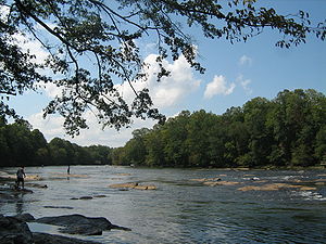
over the Apalachicola-Chattahoochee-Flint River Basin
and the Alabama-Coosa-Tallapoosa River Basin. Lake Lanier
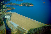
in Georgia, created by the Buford Dam, is a major cause of the issue due to the State of Georgia's capability to control the water levels of both river basins by regulating the flow of water from Lake Lanier to Alabama and Florida.
 In 1938, the U.S. Army Corps of Engineers produced a report for the U.S. Congress
that suggested a list of potential hydropower
projects. One of the suggested dam
s was the Buford Dam for Lake Lanier in Georgia. In addition to providing hydroelectric power, the dam could also allow Atlanta the means by which to grow if, in the future, the city needed additional water resources. Additional objectives for the dam included reducing flood
ing downstream during heavy rains and allowing for easier navigation
on Georgia waterways.
Congress authorized the construction of Buford Dam in 1946, and the dam was completed in 1957. As Atlanta's population continued to grow from the time the dam was built, the need for water also grew. In 1989, the Corps of Engineers released a report that some of the water that was being used for hydroelectric power should, instead, be used to supply Atlanta with water.
against Georgia and the Army Corps of Engineers in 1990. Florida did the same later that year. Alabama challenged the Corps' recommendation of the reallocation of the water supply, arguing that the Corps' recommendation had favored Georgia's interests and had ignored the National Environmental Policy Act (NEPA)
of 1969 and the impact on the environment. Florida cited the impact of the dam's operations on endangered species
as well as NEPA violations.
-Chattahoochee
-Flint
(ACF
) between Alabama and Georgia and the Alabama
-Coosa
-Tallapoosa
(ACT) between Alabama, Georgia, and Florida. These compacts, however, were not successful, and were allowed to expire in 2003 and 2004, for the ACF and the ACT respectively. Several issues that the states could not come to an agreement on are minimum flow requirements, general operation standards, and consumption caps. Georgia argued that if the flow standards are met, then minimum flow requirements are unnecessary. Georgia and the Corps of Engineers reached an agreement that reduced their water usage from Lake Lanier, but in 2008, the U.S. Court of Appeals for the District of Columbia ruled that this type of change in the agreement required Congressional approval. At various times, the governors of each of the three states have met, but these meetings have only created deadline extensions. When U.S. Interior Secretary Ken Salazar visited Georgia in 2009, he stated that he would not force the states into any agreement, but he would help them come to an agreement.
and the Etowah River
in North Georgia could sustain the water needs of the metro Atlanta area. Georgia's main concern is whether or not they have the capability to supply over 5.6 million people in the metro Atlanta area with potable water
.
Because of Georgia's need to supply a booming population with safe, usable water, Georgia's circumstance is unique to the three states involved. The interstate water dispute becomes an intrastate issue for Georgia because of the major quantities of water needed for supporting population growth in the metro Atlanta; Georgia's downstream users maintain that an increase in the water consumption of metro Atlanta results in a decrease of available water for the downstream users of south Georgia. Farmers in Southwest Georgia and homeowners on West Point Lake
perceive metro Atlanta as the enemy.
For the past two decades, Georgia's leadership has failed to produce significant agreements with Alabama and Florida. Many people blame the course of action which leaders of the state have chosen to take when dealing with this issue. The old course of "Conflict, Conceal, and Capture" has not resulted in any progress. Rather than encouraging interstate cooperation, leaders of Georgia have created conflict by placing the needs of metro Atlanta in contention with the needs of downstream users, both in-state and out-of-state. Georgia leaders maintain that negotiations must be secret, even though this approach fails to produce results and loses public confidence in the possibility of a solution. Finally, money is being spent on expensive engineering and sophisticated piping, solutions that do not promise to provide more efficient methods to use water. The solution proposed in December 2009 by former Governor Sonny Perdue's Water Contingency Planning Task Force includes a greater amount of water conservation and further negotiation regarding the reallocation of portions of Lake Lanier for the purpose of supplying the needs of metro Atlanta. Nathan Deal, current Governor of Georgia, is currently emphasizing resolving the conflict with Alabama by seeking new solutions to Atlanta's need for water.
, power generation, navigation, and water quality, all of which Atlanta's usage may limit. Alabama has been straightforward in identifying its purposes throughout the ACF negotiations. The specific goals include adequate water levels of the Chattahoochee River through the Alabama cities of Phenix City
and Columbia
, perpetuation of waste assimilation and water use permits in the middle regions of the Chattahoochee River, continuation of the Corps' projects such as hydropower and flood control, preservation of water levels of the Alabama lakes of West Point Lake
and Lake Eufaula
, and insuring that all current and future plans do not adversely affect the stated goals.
of Northwestern Florida, where major shrimping and other seafood industries provide significant income for the state. These industries are vital to the Apalachicola Bay area because these industries bring millions of dollars to the region and provide thousands of jobs for people. Unlike Georgia, where the issue over the use of freshwater is centered on the capability to provide a growing population with freshwater, Florida is faced with economic challenges if the water from upstream is diminished.
occur and the water of the ACF and the ATF river basins is not allowed to flow freely due to use of Lake Lanier for Atlanta water consumption. These two river basins are also the habitat for countless numbers of fish and other aquatic life, which need a proper amount of water to thrive. If the water levels fall too low, then this aquatic life may suffer. Endangered species of both sturgeon and mussel live in the basins and reducing the water supply to the basins would put these endangered species in further jeopardy. Further, NEPA requires the submittal of an environmental impact statement
(EIS) before any action with potentially major environmental effects. Such a statement has not been created, indicating the full environmental impact has not been assessed.
In Florida, there are major environmental implications. The Apalachicola Bay
provides 35 percent of the freshwater input to the eastern Gulf of Mexico
, which is vital to the richly productive estuaries
in this region. The key to the estuary is the fluctuation salinity
levels produced by the ACF's freshwater flow. A reduced flow of fresh water into these estuaries would drive salinity levels higher, altering the whole balance of the marine life.
On 17 July 2009, U.S. District Judge Paul Magnuson
ruled that metropolitan Atlanta was prohibited from taking water out of Lake Lanier in order for a three-year negotiation period to begin among Georgia, Alabama, and Florida. On 5 October 2009, Judge Magnuson once again ruled against Georgia in response to an appeal made by Georgia on the July ruling. The ruling also stated that Georgia should stop filing claims and appeals and earnestly seek a solution to the dispute. On 20 January 2010, the October 2009 ruling that stated that Georgia was not allowed to appeal the decision by Judge Magnuson was overturned by the 11th U.S. Circuit Court of Appeals.
Georgia (U.S. state)
Georgia is a state located in the southeastern United States. It was established in 1732, the last of the original Thirteen Colonies. The state is named after King George II of Great Britain. Georgia was the fourth state to ratify the United States Constitution, on January 2, 1788...
, Alabama
Alabama
Alabama is a state located in the southeastern region of the United States. It is bordered by Tennessee to the north, Georgia to the east, Florida and the Gulf of Mexico to the south, and Mississippi to the west. Alabama ranks 30th in total land area and ranks second in the size of its inland...
, and Florida
Florida
Florida is a state in the southeastern United States, located on the nation's Atlantic and Gulf coasts. It is bordered to the west by the Gulf of Mexico, to the north by Alabama and Georgia and to the east by the Atlantic Ocean. With a population of 18,801,310 as measured by the 2010 census, it...
over the Apalachicola-Chattahoochee-Flint River Basin
ACF River Basin
The ACF River Basin is the watershed of the Apalachicola/Chattahoochee/Flint River Basin, in the United States, that begins in northern Georgia and flows into the Gulf of Mexico at Apalachicola Bay, near Apalachicola, Florida...
and the Alabama-Coosa-Tallapoosa River Basin. Lake Lanier
Lake Lanier
Lake Lanier is a reservoir in the northern portion of the U.S. state of Georgia. It was created by the completion of Buford Dam on the Chattahoochee River in 1956, and is also fed by the waters of the Chestatee River. The lake encompasses of water, and of shoreline at normal level, a "full...
in Georgia, created by the Buford Dam, is a major cause of the issue due to the State of Georgia's capability to control the water levels of both river basins by regulating the flow of water from Lake Lanier to Alabama and Florida.
Buford Dam
United States Congress
The United States Congress is the bicameral legislature of the federal government of the United States, consisting of the Senate and the House of Representatives. The Congress meets in the United States Capitol in Washington, D.C....
that suggested a list of potential hydropower
Hydropower
Hydropower, hydraulic power, hydrokinetic power or water power is power that is derived from the force or energy of falling water, which may be harnessed for useful purposes. Since ancient times, hydropower has been used for irrigation and the operation of various mechanical devices, such as...
projects. One of the suggested dam
Dam
A dam is a barrier that impounds water or underground streams. Dams generally serve the primary purpose of retaining water, while other structures such as floodgates or levees are used to manage or prevent water flow into specific land regions. Hydropower and pumped-storage hydroelectricity are...
s was the Buford Dam for Lake Lanier in Georgia. In addition to providing hydroelectric power, the dam could also allow Atlanta the means by which to grow if, in the future, the city needed additional water resources. Additional objectives for the dam included reducing flood
Flood
A flood is an overflow of an expanse of water that submerges land. The EU Floods directive defines a flood as a temporary covering by water of land not normally covered by water...
ing downstream during heavy rains and allowing for easier navigation
Navigation
Navigation is the process of monitoring and controlling the movement of a craft or vehicle from one place to another. It is also the term of art used for the specialized knowledge used by navigators to perform navigation tasks...
on Georgia waterways.
Congress authorized the construction of Buford Dam in 1946, and the dam was completed in 1957. As Atlanta's population continued to grow from the time the dam was built, the need for water also grew. In 1989, the Corps of Engineers released a report that some of the water that was being used for hydroelectric power should, instead, be used to supply Atlanta with water.
Alabama lawsuit
As a result of this recommendation, Alabama filed a lawsuitLawsuit
A lawsuit or "suit in law" is a civil action brought in a court of law in which a plaintiff, a party who claims to have incurred loss as a result of a defendant's actions, demands a legal or equitable remedy. The defendant is required to respond to the plaintiff's complaint...
against Georgia and the Army Corps of Engineers in 1990. Florida did the same later that year. Alabama challenged the Corps' recommendation of the reallocation of the water supply, arguing that the Corps' recommendation had favored Georgia's interests and had ignored the National Environmental Policy Act (NEPA)
National Environmental Policy Act
The National Environmental Policy Act is a United States environmental law that established a U.S. national policy promoting the enhancement of the environment and also established the President's Council on Environmental Quality ....
of 1969 and the impact on the environment. Florida cited the impact of the dam's operations on endangered species
Endangered species
An endangered species is a population of organisms which is at risk of becoming extinct because it is either few in numbers, or threatened by changing environmental or predation parameters...
as well as NEPA violations.
Since 1990
After the 1990 lawsuit was filed in Alabama, parties on both sides decided to suspend legal procedures in an effort to reach an agreement suitable to all three states. In 1997, two different compacts were created: the ApalachicolaApalachicola River
The Apalachicola River is a river, approximately 112 mi long in the State of Florida. This river's large watershed, known as the ACF River Basin for short, drains an area of approximately into the Gulf of Mexico. The distance to its farthest headstream in northeast Georgia is approximately 500...
-Chattahoochee
Chattahoochee River
The Chattahoochee River flows through or along the borders of the U.S. states of Georgia, Alabama, and Florida. It is a tributary of the Apalachicola River, a relatively short river formed by the confluence of the Chattahoochee and Flint Rivers and emptying into Apalachicola Bay in the Gulf of...
-Flint
Flint River (Georgia)
The Flint River is a river in the U.S. state of Georgia. The river drains of western Georgia, flowing south from the upper Piedmont region south of Atlanta to the wetlands of the Gulf Coastal Plain in the southwestern corner of the state. Along with the Apalachicola and the Chattahoochee rivers,...
(ACF
ACF River Basin
The ACF River Basin is the watershed of the Apalachicola/Chattahoochee/Flint River Basin, in the United States, that begins in northern Georgia and flows into the Gulf of Mexico at Apalachicola Bay, near Apalachicola, Florida...
) between Alabama and Georgia and the Alabama
Alabama River
The Alabama River, in the U.S. state of Alabama, is formed by the Tallapoosa and Coosa rivers, which unite about north of Montgomery.The river flows west to Selma, then southwest until, about from Mobile, it unites with the Tombigbee, forming the Mobile and Tensaw rivers, which discharge into...
-Coosa
Coosa River
The Coosa River is a tributary of the Alabama River in the U.S. states of Alabama and Georgia. The river is about long altogether.The Coosa River is one of Alabama's most developed rivers...
-Tallapoosa
Tallapoosa River
The Tallapoosa River runs from the southern end of the Appalachian Mountains in Georgia, in the United States, southward and westward into Alabama. It is formed by the confluence of McClendon Creek and Mud Creek in Paulding County, Georgia. Lake Martin at Alexander City, Alabama is a large and...
(ACT) between Alabama, Georgia, and Florida. These compacts, however, were not successful, and were allowed to expire in 2003 and 2004, for the ACF and the ACT respectively. Several issues that the states could not come to an agreement on are minimum flow requirements, general operation standards, and consumption caps. Georgia argued that if the flow standards are met, then minimum flow requirements are unnecessary. Georgia and the Corps of Engineers reached an agreement that reduced their water usage from Lake Lanier, but in 2008, the U.S. Court of Appeals for the District of Columbia ruled that this type of change in the agreement required Congressional approval. At various times, the governors of each of the three states have met, but these meetings have only created deadline extensions. When U.S. Interior Secretary Ken Salazar visited Georgia in 2009, he stated that he would not force the states into any agreement, but he would help them come to an agreement.
Georgia
Georgia has indicated that the need for fresh water to use for human consumption is the primary concern in the issue. Experts in the metro Atlanta area assert that the people of metro Atlanta require and can safely extract 705 million gallons of fresh water per day from a number of reservoir and water basins around northern Georgia until the year 2030. Georgia states the water from Lake AllatoonaLake Allatoona
Lake Allatoona is a U.S. Army Corps of Engineers reservoir in Georgia, located in northwestern metro Atlanta. The lake is mostly in southwestern Cherokee County, but a significant part is in southeastern Bartow County, and a small part in Cobb County near Acworth. Cartersville is the nearest...
and the Etowah River
Etowah River
The Etowah River is a waterway that rises northwest of Dahlonega, Georgia, north of Atlanta. Its name is the Cherokee version of the original Muskogee word Etalwa, which means a "trail crossing". On Matthew Carey's 1795 map the river was labeled "High Town River"...
in North Georgia could sustain the water needs of the metro Atlanta area. Georgia's main concern is whether or not they have the capability to supply over 5.6 million people in the metro Atlanta area with potable water
Drinking water
Drinking water or potable water is water pure enough to be consumed or used with low risk of immediate or long term harm. In most developed countries, the water supplied to households, commerce and industry is all of drinking water standard, even though only a very small proportion is actually...
.
Because of Georgia's need to supply a booming population with safe, usable water, Georgia's circumstance is unique to the three states involved. The interstate water dispute becomes an intrastate issue for Georgia because of the major quantities of water needed for supporting population growth in the metro Atlanta; Georgia's downstream users maintain that an increase in the water consumption of metro Atlanta results in a decrease of available water for the downstream users of south Georgia. Farmers in Southwest Georgia and homeowners on West Point Lake
West Point Lake
West Point Lake is a man-made reservoir formed by the damming of the Chattahoochee River by the U.S. Army Corps of Engineers. This reservoir extends for about along the Chattahoochee River near the Alabama-Georgia state boundary....
perceive metro Atlanta as the enemy.
For the past two decades, Georgia's leadership has failed to produce significant agreements with Alabama and Florida. Many people blame the course of action which leaders of the state have chosen to take when dealing with this issue. The old course of "Conflict, Conceal, and Capture" has not resulted in any progress. Rather than encouraging interstate cooperation, leaders of Georgia have created conflict by placing the needs of metro Atlanta in contention with the needs of downstream users, both in-state and out-of-state. Georgia leaders maintain that negotiations must be secret, even though this approach fails to produce results and loses public confidence in the possibility of a solution. Finally, money is being spent on expensive engineering and sophisticated piping, solutions that do not promise to provide more efficient methods to use water. The solution proposed in December 2009 by former Governor Sonny Perdue's Water Contingency Planning Task Force includes a greater amount of water conservation and further negotiation regarding the reallocation of portions of Lake Lanier for the purpose of supplying the needs of metro Atlanta. Nathan Deal, current Governor of Georgia, is currently emphasizing resolving the conflict with Alabama by seeking new solutions to Atlanta's need for water.
Alabama
Alabama actively utilizes the ACF River Basin for a variety of purposes to include agriculture, industry, fisheries, recreation, preservation of habitats and biodiversityBiodiversity
Biodiversity is the degree of variation of life forms within a given ecosystem, biome, or an entire planet. Biodiversity is a measure of the health of ecosystems. Biodiversity is in part a function of climate. In terrestrial habitats, tropical regions are typically rich whereas polar regions...
, power generation, navigation, and water quality, all of which Atlanta's usage may limit. Alabama has been straightforward in identifying its purposes throughout the ACF negotiations. The specific goals include adequate water levels of the Chattahoochee River through the Alabama cities of Phenix City
Phenix City, Alabama
Phenix City is a city and the county seat in Russell County in the U.S. state of Alabama. Portions of Lee County are addressed as Phenix City, 36870 ZIP code, for the sole purpose that Smiths Station does not have full incorporation to annex the area...
and Columbia
Columbia, Alabama
Columbia is a town in Houston County, Alabama, United States. It is part of the Dothan, Alabama Metropolitan Statistical Area. At the 2000 census the population was 804.-Geography:Columbia is located at . According to the U.S...
, perpetuation of waste assimilation and water use permits in the middle regions of the Chattahoochee River, continuation of the Corps' projects such as hydropower and flood control, preservation of water levels of the Alabama lakes of West Point Lake
West Point Lake
West Point Lake is a man-made reservoir formed by the damming of the Chattahoochee River by the U.S. Army Corps of Engineers. This reservoir extends for about along the Chattahoochee River near the Alabama-Georgia state boundary....
and Lake Eufaula
Walter F. George Lake
The Walter F. George Lake, named for Walter F. George , a United States Senator from Georgia, is formed on the Chattahoochee River along the border between Alabama and Georgia. It is also widely known by the unofficial name, Lake Eufaula — particularly on the Alabama side. The lake extends north...
, and insuring that all current and future plans do not adversely affect the stated goals.
Florida
As another downstream user of the ACF River Basin, Florida wants and needs enough freshwater to reach the Apalachicola BayApalachicola Bay
Apalachicola Bay is an estuary and lagoon located on Florida's northwest coast renowned for its oysters. The Apalachicola Bay system also includes St. Georges Sound, St. Vincent Sound and East Bay, covering an area of about . Four islands St. Vincent Island to the west, Cape St. George Island and St...
of Northwestern Florida, where major shrimping and other seafood industries provide significant income for the state. These industries are vital to the Apalachicola Bay area because these industries bring millions of dollars to the region and provide thousands of jobs for people. Unlike Georgia, where the issue over the use of freshwater is centered on the capability to provide a growing population with freshwater, Florida is faced with economic challenges if the water from upstream is diminished.
Stakeholders
As all three states have portions of the ACF river basin, ACT river basin, or both within their borders, Georgia, Alabama, and Florida are concerned with and involved in the issue. The U.S. Army Corps of Engineers created Lake Lanier and controls its flow of water, involving the Corps in the dispute. Concerned with the environmental effects of the two river basins, the Tri-State Conservation Coalition—a league of more than 45 organizations including the Alabama Rivers Alliance, Southern Environmental Law Center, American Rivers, Lake Watch of Lake Martin, and Upper Chattahoochee Riverkeeper—is involved with the goal of preserving the water quality and other environmental factors.Environmental impact
Alabama is concerned about the environmental results should droughtDrought
A drought is an extended period of months or years when a region notes a deficiency in its water supply. Generally, this occurs when a region receives consistently below average precipitation. It can have a substantial impact on the ecosystem and agriculture of the affected region...
occur and the water of the ACF and the ATF river basins is not allowed to flow freely due to use of Lake Lanier for Atlanta water consumption. These two river basins are also the habitat for countless numbers of fish and other aquatic life, which need a proper amount of water to thrive. If the water levels fall too low, then this aquatic life may suffer. Endangered species of both sturgeon and mussel live in the basins and reducing the water supply to the basins would put these endangered species in further jeopardy. Further, NEPA requires the submittal of an environmental impact statement
Environmental impact statement
An environmental impact statement , under United States environmental law, is a document required by the National Environmental Policy Act for certain actions "significantly affecting the quality of the human environment". An EIS is a tool for decision making...
(EIS) before any action with potentially major environmental effects. Such a statement has not been created, indicating the full environmental impact has not been assessed.
In Florida, there are major environmental implications. The Apalachicola Bay
Apalachicola Bay
Apalachicola Bay is an estuary and lagoon located on Florida's northwest coast renowned for its oysters. The Apalachicola Bay system also includes St. Georges Sound, St. Vincent Sound and East Bay, covering an area of about . Four islands St. Vincent Island to the west, Cape St. George Island and St...
provides 35 percent of the freshwater input to the eastern Gulf of Mexico
Gulf of Mexico
The Gulf of Mexico is a partially landlocked ocean basin largely surrounded by the North American continent and the island of Cuba. It is bounded on the northeast, north and northwest by the Gulf Coast of the United States, on the southwest and south by Mexico, and on the southeast by Cuba. In...
, which is vital to the richly productive estuaries
Estuary
An estuary is a partly enclosed coastal body of water with one or more rivers or streams flowing into it, and with a free connection to the open sea....
in this region. The key to the estuary is the fluctuation salinity
Salinity
Salinity is the saltiness or dissolved salt content of a body of water. It is a general term used to describe the levels of different salts such as sodium chloride, magnesium and calcium sulfates, and bicarbonates...
levels produced by the ACF's freshwater flow. A reduced flow of fresh water into these estuaries would drive salinity levels higher, altering the whole balance of the marine life.
Current litigation
In 1990, Alabama filed suit against Georgia and the U.S. Army Corps of Engineers because of the proposal to reallocate water in Lake Lanier from hydropower uses to supplying metropolitan Atlanta with water. Florida joined Alabama in the suit. However, this suit was stayed due to the 1997 ACF and ACT compacts agreed upon by the three states to commence negotiations. Due to the expiration of the ACF compact in 2003 and the ACT in 2004, the suit is now active. During the 1997 compacts, Georgia also entered into negotiations with the Corps to allow part of Lake Lanier to be used for water consumption. In 2004, both Alabama and Florida challenged these agreements due to the preeminence of the suit filed by Alabama in 1990. In order to determine whether or not the settlement between Georgia and the Corps is valid, the D.C. Circuit Court is currently hearing an appeal by Alabama and Florida. Georgia has also sued the Corps for wrongfully prohibiting Lake Lanier to be used for water consumption for metropolitan Atlanta. Alabama and Florida have also filed amended briefs to the 1990 Alabama suit stating that an endangered aquatic species is being further threatened due to a decrease of water levels.On 17 July 2009, U.S. District Judge Paul Magnuson
Paul A. Magnuson
Paul A. Magnuson is a United States District Judge from Minnesota.Magnuson was born in Carthage, South Dakota, a small town in the eastern part of the state. He graduated from Gustavus Adolphus College in 1959, having served as president of the student body and an active member of the College...
ruled that metropolitan Atlanta was prohibited from taking water out of Lake Lanier in order for a three-year negotiation period to begin among Georgia, Alabama, and Florida. On 5 October 2009, Judge Magnuson once again ruled against Georgia in response to an appeal made by Georgia on the July ruling. The ruling also stated that Georgia should stop filing claims and appeals and earnestly seek a solution to the dispute. On 20 January 2010, the October 2009 ruling that stated that Georgia was not allowed to appeal the decision by Judge Magnuson was overturned by the 11th U.S. Circuit Court of Appeals.