

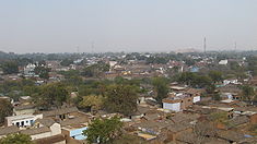
Kulpahar
Encyclopedia
Kulpahar is a city in Mahoba district
in the India
n state
of Uttar Pradesh
. It is a historical town in the Bundelkhand
region. Before 11 Feb 1995 Kulpahar was a Tehsil of Hamirpur District
. On 11 Feb 1995 Mahoba District
was carved out of Hamirpur, and Kulpahar is now a part of the Mahoba District. Kulpahar is the largest Subdivision of Uttar Pradesh
. Kulpahar is known for its closeness to Khajuraho
and other historic places like Mahoba
, Charkhari
, Kalinjar
Rath, India
, Orchha
, and Jhansi
. This town holds relics of temple
s and man-made water bodies of the Chandela
Dynasty
.
i. Two village theory - According to the Imperial gazetteer of United Province of Agra and Oudh -1909 there were two different villages Kulhua and paharia which later jointly became the town of Kulpahar; even the folklore says the same. It doesn't have any supporting evidence for the theory; it seems that the British writer of the gazetteer went by the folklore.
ii. Second theory is based on some historical facts dating back early 17th century. There was a cult gossain in the central India and one of the descendant of the followers of this cult Himmat Bahadur Gossain who actively took part in Indian freedom struggle was born in Kulpahar and Kulpahar had connection with this cult since the origin of the cult. Gossain cult is believed to be originated/started from Kulpahar. Historians who relate Kulpahar with the gossain cult gave the theory that Kulpahar word is composed of two words Kula and pahar means Clan mountain. Some relates it with a tantrik rite Kaula Tantra. Kulpahar was a site to perform secret tantrik rituals of gossain cult on a hill near Gahra lake; hence the town got its name Kaula pahar which as the time passed became Kulpahar.
of the same name in British India. Kulpahar was founded in 1700 by Raja Jagat Raj of Jaitpur son of Maharaja Chhatrasal
, and was reorganized by Senapati, a Bundela
Rajput
who was the son of Raja Jagat Raj of Jaitpur grandson of Maharaja Chhatrasal
. Kulpahar was captured by the British in 1804, and became a princely state in the Bundelkhand
Agency of the Central India Agency
. The chief resided at the town of Nowgong
in Madhya Pradesh
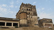
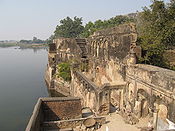
. The fort of Kulpahar, situated on a steep hill, towers more than 800 ft (244 m) above the sea level, and contains the ruins of elaborately carved sculptures.
Brief history of Kulpahar is covered under the section of origin. Not much information is available about the medieval and ancient history of Kulpahar but the remains of structures dating back 9th and 10th century confirms the existence and importance of Kulpahar in the ancient and medieval India.
After the Mughals' fall and the rise of Chhatrasal Bundela, Kulpahar passed under his sway but failed to acquire and kind of pre-eminence. In the 17th century Chhatrasal declared independence and put a stiff resistance against Aurangzeb. He established a Bundella Principality and Bahadur Shah Moghal had to confirm all his acquisitions in the area called 'Bundelkhand'. There was a revival of hostilities during the region of reign of Farrukhsiyar when his general Mohammed Khan Bangash invaded Bundelkhand in the year 1729 AD and the aged ruler Chatrasal had to seek aid from Peshwa Baji rao. His 'Maratha'army of 70,000 men dashed from Indore (Malwa) and encamped at Mahoba. They surrounded forces of nawab Banghash who had captured Jaitpur, Belatal, Mudhari and Kulpahar etc. The Peshwa inflicted a crushing defeat over the Nawab by annihilating his forces in the dense forests of Jaitpur, Mudhari and Salat near Kulpahar. In return for this help, Chhatrasal bequeathed one third of his dominion to the Maratha Chieftain. That part included Mahoba, Shri Nagar, Jaitpur, Kulpahar etc. Later, under the treaty Bessien in 1803 AD the marathas ceded Bundelkhand area to British rulers. Its administration was , however, carried over by the subedar of Jalaun until 1858 AD when it was finally annexed by the East India Company. Kulpahar was made the head-quarter of a Tehsil under the sub-division of Mahoba in the district of Hamirpur.
Some of the sites are:
and 278 km from Allahabad
at an altitude of 795 feet (242.3 m) at Latitude 25° 19' N, Longitude 79° 39' E.
 Kulpahar is the headquarter of a subdistrict which is headed by a Deputy District Magistrate. The same officer holds the court of Town Megistrate of Kulpahar. Deputy district Magistrate is assisted by four officers one Tehsil Magistrate and three Nayab Tehsil Magistrates. Tehsildar looks into all the revenue matter of whole of sub district and is assisted by three nayabs who look after the three divisions of kulpahar namely Jaitpur, Panwari, and Kulpahar city.
 Kulpahar city's security is maintained by Kulpahar Kotwali. An officer of the cadre of Deputy Superintendent of Police heads the police administration of Kulpahar. Kulpahar Kotwali is headed by Kotwal an officer of Inspector cadre. Kulpahar police circle consists of 5 police stations namely
where the Chitrakoot Jalkal Sansthaan has a water filter plant with a capacity of 15,000,000 litre per day.
In the month of august and September famous fair of Jalvihar is organized in the city. It is month long celebration. during the opening day of fair idols of all the temples of town are taken out of the temple and a procession takes place.
leaf of Mahoba
.
airport (90 km) and is linked to Mumbai
, Delhi
, Varanasi
and Agra
by Jet Airways
and Indian Airlines. Other airports in the vicinity are Kanpur (180 km) and Lucknow
(250 km).
and Allahabad
on this highway. Another highway that links Kulpahar is National Highway 74 starts at Kanpur and ends at Sagar in Madhya Pradesh
. There are other highways that link Kulpahar to other parts of the state. Kulpahar also has one bus station and a railway station catering to different routes. Regular bus services are available to nearby towns like Mahoba
, Banda
, Nowgaon
, Charkhari
, Rath
, Orai
, Chitrakoot, Karwi
, Hamirpur
and Kulpahar is also well connected with bus services to Allahabad
, Varanasi
, Kanpur, Lucknow
, Delhi
, Agra
, Jhansi
, Jaipur
and Ajmer
.
Tourist taxis, auto-rickshaws and tempos are available for local transport. But the cheapest and most efficient method of local transport is the Tonga. Rates are not fixed and one needs to bargain.
, Delhi
, Mumbai
, Jhansi
, Varanasi
, Agra
, Gwalior, Jabalpur, Gaya
, Mathura and Allahabad
.
Major Trains connecting Kulpahar with rest of the country are 1107/1108 Bundelkhand Exp, 2175/2176 Gwalior-Howrah Chambal Exp, 2177/2178 Mathura-Howrah Chambal Exp, 2189/2190 Mahakoshal Exp, 1069/1070 Tulsi Exp and 2447/2448 Uttar Pradesh Sampark Kranti Exp.
 Kulpahar region comprises areas which are essentially covered by grey, pink, red granitic rock
and black dolerite. The rocks are generally medium to coarse to very coarse grained, having variegated colours with varying textural patterns. In geological nomenclature they can be classified on the basis of colour, grain size and texture. Over half of the areas identified so far appear suitable for extracting blocks of two cubic meters in size from the surface outcrops. The granite with red feldspar
having presence of white and bluish quartz
has caught the fancy of buyers and has become quite popular in national and international markets during the last 10 years, The remaining outcrops would be suited for blocks of smaller size. Ruby red granite
is good in quality and is very popular in national and international markets, In granitic terrain
the rocks may occur in the form of widespread sheets exposed above the ground level, in the form of hillocks, as high ground or below the ground under soil cover. They may also occur as boulders of different size and shapes spread over the sheet rock. They may be found as dykes, particularly of black and green types, as long narrow ridge
s often concealed beneath the surface. A major part of granite deposits in these regions are underground and have to be extracted by open cast mining. Underground granite block is more compact and require sophisticated and specialised machinery which adds to the cost of mining
.
, Kulpahar had a population of 17,437. Males constitute 52% of the population and females 48%. Kulpahar has an average literacy rate of 65.50%, higher than the national average of 59.5%. In Kulpahar, 18% of the population is under 6 years of age.
Mahoba District
Mahoba district is one of the districts of Uttar Pradesh state of India and Mahoba town is the district headquarters. Mahoba district is a part of Chitrakoot Division. The district occupies an area of 2884 km². It has a population of 708,447...
in the India
India
India , officially the Republic of India , is a country in South Asia. It is the seventh-largest country by geographical area, the second-most populous country with over 1.2 billion people, and the most populous democracy in the world...
n state
States and territories of India
India is a federal union of states comprising twenty-eight states and seven union territories. The states and territories are further subdivided into districts and so on.-List of states and territories:...
of Uttar Pradesh
Uttar Pradesh
Uttar Pradesh abbreviation U.P. , is a state located in the northern part of India. With a population of over 200 million people, it is India's most populous state, as well as the world's most populous sub-national entity...
. It is a historical town in the Bundelkhand
Bundelkhand
Bundelkhand anciently known as Chedi Kingdom is a geographic region of central India...
region. Before 11 Feb 1995 Kulpahar was a Tehsil of Hamirpur District
Hamirpur District, Uttar Pradesh
Hamirpur district is one of the 70 districts of Uttar Pradesh state of India and Hamirpur town is the district headquarters. Hamirpur district is a part of Chitrakoot Division. The district occupies an area of 4,121.9 km². The district has a population of 1,042,374...
. On 11 Feb 1995 Mahoba District
Mahoba District
Mahoba district is one of the districts of Uttar Pradesh state of India and Mahoba town is the district headquarters. Mahoba district is a part of Chitrakoot Division. The district occupies an area of 2884 km². It has a population of 708,447...
was carved out of Hamirpur, and Kulpahar is now a part of the Mahoba District. Kulpahar is the largest Subdivision of Uttar Pradesh
Uttar Pradesh
Uttar Pradesh abbreviation U.P. , is a state located in the northern part of India. With a population of over 200 million people, it is India's most populous state, as well as the world's most populous sub-national entity...
. Kulpahar is known for its closeness to Khajuraho
Khajuraho
The Khajuraho Group of Monuments in Khajuraho , a town in the Indian state of Madhya Pradesh, located in Chhatarpur District, about southeast of New Delhi, are one of the most popular tourist destinations in India. Khajuraho has the largest group of medieval Hindu and Jain temples, famous for...
and other historic places like Mahoba
Mahoba
Mahoba is a city and Mahoba District of the Indian state of Uttar Pradesh, in the Bundelkhand region. Mahoba is known for its closeness to Khajuraho, Laundi and other historic places like Kulpahar, Charkhari, Kalinjar, Orchha, and Jhansi...
, Charkhari
Charkhari
Charkhari, currently a part of Uttar Pradesh state, was one of the Princely states of India during the period of the British Raj. The state was founded by saurabh singh bundela, a Rajput of Bundela clan. On India’s independence, this Princely state was acceded to India.-Geography:Charkhari is...
, Kalinjar
Kalinjar
Kalinjar is a fortress-city in the Bundelkhand region of central India. Kalinjar is located in Banda District of Uttar Pradesh state, near the temple-city and World Heritage Site of Khajuraho. The fortress is strategically located on an isolated rocky hill at the end the Vindhya Range, at an...
Rath, India
Rath, India
Rath is a city and a municipal board in Hamirpur district in the Indian state of Uttar Pradesh. Rath is a Tehsil of Hamirpur District. It is situted at 506 km. north-south from New Delhi.-History:...
, Orchha
Orchha
Orchha is a town in Tikamgarh district of Madhya Pradesh state, India. The town was established by Maharaja Rudra Pratap Singh in 1501, as the seat of an eponymous former princely state of central India, in the Bundelkhand region. Orchha lies on the Betwa River , 80 km from Tikamgarh &...
, and Jhansi
Jhansi
Jhansi Hindi:झाँसी, , Marathi: झाशी, is a historical city of India. Jhansi is the administrative headquarters of Jhansi District and Jhansi Division. The original walled city grew up around its stone fort, which crowns a neighboring rock. This district is on the bank of river Betwa.The National...
. This town holds relics of temple
Temple
A temple is a structure reserved for religious or spiritual activities, such as prayer and sacrifice, or analogous rites. A templum constituted a sacred precinct as defined by a priest, or augur. It has the same root as the word "template," a plan in preparation of the building that was marked out...
s and man-made water bodies of the Chandela
Chandela
The Chandela is a Rajput clan found in North India. A section of the Chandelas ruled much of the Bundelkhand region of central India for long periods between the 10th and the 13th centuries AD. The Chandela dynasty is famous in Indian history for King Vidyadhar, who repulsed the attacks of Mahmud...
Dynasty
Dynasty
A dynasty is a sequence of rulers considered members of the same family. Historians traditionally consider many sovereign states' history within a framework of successive dynasties, e.g., China, Ancient Egypt and the Persian Empire...
.
Origin of the name
Historians have different theories about the origin of its name, primarily there are two opinions about the name.i. Two village theory - According to the Imperial gazetteer of United Province of Agra and Oudh -1909 there were two different villages Kulhua and paharia which later jointly became the town of Kulpahar; even the folklore says the same. It doesn't have any supporting evidence for the theory; it seems that the British writer of the gazetteer went by the folklore.
ii. Second theory is based on some historical facts dating back early 17th century. There was a cult gossain in the central India and one of the descendant of the followers of this cult Himmat Bahadur Gossain who actively took part in Indian freedom struggle was born in Kulpahar and Kulpahar had connection with this cult since the origin of the cult. Gossain cult is believed to be originated/started from Kulpahar. Historians who relate Kulpahar with the gossain cult gave the theory that Kulpahar word is composed of two words Kula and pahar means Clan mountain. Some relates it with a tantrik rite Kaula Tantra. Kulpahar was a site to perform secret tantrik rituals of gossain cult on a hill near Gahra lake; hence the town got its name Kaula pahar which as the time passed became Kulpahar.
History
Kulpahar was the capital of a princely statePrincely state
A Princely State was a nominally sovereign entitity of British rule in India that was not directly governed by the British, but rather by an Indian ruler under a form of indirect rule such as suzerainty or paramountcy.-British relationship with the Princely States:India under the British Raj ...
of the same name in British India. Kulpahar was founded in 1700 by Raja Jagat Raj of Jaitpur son of Maharaja Chhatrasal
Maharaja Chhatrasal
Budelkhand Kesri Maharaja Chhatrasal , was a Bundeli warrior who chose to turn against the Mughal Emperor Aurangzeb and seek to establish his own kingdom in Bundelkhand....
, and was reorganized by Senapati, a Bundela
Bundela
The Bundelas are a Rajput clan of Chattari lineage who ruled several states in central India, in Bundelkhand region from the 16th century.The Bundelas are the most prominent Rajputs hailing from Central India...
Rajput
Rajput
A Rajput is a member of one of the patrilineal clans of western, central, northern India and in some parts of Pakistan. Rajputs are descendants of one of the major ruling warrior classes in the Indian subcontinent, particularly North India...
who was the son of Raja Jagat Raj of Jaitpur grandson of Maharaja Chhatrasal
Maharaja Chhatrasal
Budelkhand Kesri Maharaja Chhatrasal , was a Bundeli warrior who chose to turn against the Mughal Emperor Aurangzeb and seek to establish his own kingdom in Bundelkhand....
. Kulpahar was captured by the British in 1804, and became a princely state in the Bundelkhand
Bundelkhand
Bundelkhand anciently known as Chedi Kingdom is a geographic region of central India...
Agency of the Central India Agency
Central India Agency
The Central India Agency was a political office of the British Indian Empire, which covered the northern half of present-day Madhya Pradesh state. The Central India Agency was made up entirely of princely states, which were under native rulers...
. The chief resided at the town of Nowgong
Nowgong
Nowgong can refer to:* Naogaon District, Bangladesh* Nagaon - a city in Nagaon district, Assam, India*Nowgong, Chhatarpur - a city and former military center, Chattarpur District, Madhya Pradesh, India...
in Madhya Pradesh
Madhya Pradesh
Madhya Pradesh , often called the Heart of India, is a state in central India. Its capital is Bhopal and Indore is the largest city....
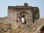
. The fort of Kulpahar, situated on a steep hill, towers more than 800 ft (244 m) above the sea level, and contains the ruins of elaborately carved sculptures.
Brief history of Kulpahar is covered under the section of origin. Not much information is available about the medieval and ancient history of Kulpahar but the remains of structures dating back 9th and 10th century confirms the existence and importance of Kulpahar in the ancient and medieval India.
After the Mughals' fall and the rise of Chhatrasal Bundela, Kulpahar passed under his sway but failed to acquire and kind of pre-eminence. In the 17th century Chhatrasal declared independence and put a stiff resistance against Aurangzeb. He established a Bundella Principality and Bahadur Shah Moghal had to confirm all his acquisitions in the area called 'Bundelkhand'. There was a revival of hostilities during the region of reign of Farrukhsiyar when his general Mohammed Khan Bangash invaded Bundelkhand in the year 1729 AD and the aged ruler Chatrasal had to seek aid from Peshwa Baji rao. His 'Maratha'army of 70,000 men dashed from Indore (Malwa) and encamped at Mahoba. They surrounded forces of nawab Banghash who had captured Jaitpur, Belatal, Mudhari and Kulpahar etc. The Peshwa inflicted a crushing defeat over the Nawab by annihilating his forces in the dense forests of Jaitpur, Mudhari and Salat near Kulpahar. In return for this help, Chhatrasal bequeathed one third of his dominion to the Maratha Chieftain. That part included Mahoba, Shri Nagar, Jaitpur, Kulpahar etc. Later, under the treaty Bessien in 1803 AD the marathas ceded Bundelkhand area to British rulers. Its administration was , however, carried over by the subedar of Jalaun until 1858 AD when it was finally annexed by the East India Company. Kulpahar was made the head-quarter of a Tehsil under the sub-division of Mahoba in the district of Hamirpur.
Archaeological sites
There are quite a few Archaeological sites in and near Kulpahar of period 10th century.Some of the sites are:
- Senapati MahalSenapati MahalSenapati Mahal is a palace built by Senapati, son of Jagat Rai and grandson of Chhatrasal in 1700 in Kulpahar on a hillock. The palace is now a protected monument....
- This beautiful small palace was built by Raja Jagatraj of Jaitpur in early 18th century AD for his son Senapati. It is a triple storied tall beautiful building situated on Kulpahar-Nowgong road near KM 1 milestone just opposite to collectorate. Archaeological Survey of India has started renovation work, it has been declared a monument of national importance in 1996 AD. - ChandelaChandelaThe Chandela is a Rajput clan found in North India. A section of the Chandelas ruled much of the Bundelkhand region of central India for long periods between the 10th and the 13th centuries AD. The Chandela dynasty is famous in Indian history for King Vidyadhar, who repulsed the attacks of Mahmud...
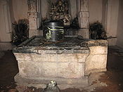
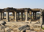
period YajnaYajnaIn Hinduism, yajna is a ritual of sacrifice derived from the practice of Vedic times. It is performed to please the gods or to attain certain wishes...
Mandap near village AkonaAkonaAkona is a tiny village 15 km south-east of Kulpahar. It has many ruins of the Chandela dynasty....
- It is a large Hindu yajna mandap situated on Jaitpur-Srinagar road. This mandap dates back 10th century AD. It is 20x20x20 cubic feet area. On the southern side of this mandap is a granite Shivalingam. This area was built by chandela rulers to carryout most auspicious Hindu rituals. - Senapati fortressSenapati fortressSenapati fortress was built by Senapati, the grandson of Chhatrasal in 1700 AD in Kulpahar on a hill at the western end of the city. This fort was dismentled by British in 1804 AD.-See also:* Senapati Mahal...
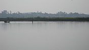
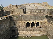
- This is a small fortification around Senapati palace built by Senapati in mid 18th century when he was managing the security of Kulpahar area during his father Raja Jagatraj's reign. - Raja Ka TalRaja Ka TalRaja Ka Tal was built by Senapati, the grandson of Maharaja Chhatrasal in 1707 AD. It is locally known as bara tal....
lake - It is a large lake built by Jagatraj in the early 18th century AD. Total area of this covers over 2 square km. It was the main source of irrigation and drinking water supply during his reign. - Belasagar lake - It is situated alongside the Kulpahar-Nowgong road 10 km from Kulpahar bus station. It is one of the largest lakes of the area. It was built by Raja Parikshit of Jaitpur in the loving memory of his wife Bela during last decade of 19th century. It covers an area of over 8 square km. This lake is bounded by Kulpahar-Nowgong road on one side and Jaitur-Srinagar road on other side. It is the major source for irrigation and drinking water for Kulpahar area. On the embankment of this lake ruins of forts of Raja Jagatraj and Raja Parikshit exists on a hillock.
- ChandelaChandelaThe Chandela is a Rajput clan found in North India. A section of the Chandelas ruled much of the Bundelkhand region of central India for long periods between the 10th and the 13th centuries AD. The Chandela dynasty is famous in Indian history for King Vidyadhar, who repulsed the attacks of Mahmud...
period templeTempleA temple is a structure reserved for religious or spiritual activities, such as prayer and sacrifice, or analogous rites. A templum constituted a sacred precinct as defined by a priest, or augur. It has the same root as the word "template," a plan in preparation of the building that was marked out...
s near village RawatpuraRawatpura, KulpaharRawatpura is a tiny village 10 km east of Kulpahar. It has many ruins of temples of Chandela dynasty....
, SalatSalat, KulpaharSalat is a village in Kulpahar subdistrict in Uttar Pradesh....
and Akona - These temples resembles the famous architecture of Khajuraho temples. These were built during 9th-10th century AD by chandela rulers who built the famous Kamasutra temples of Khajuraho. - Four ChandelaChandelaThe Chandela is a Rajput clan found in North India. A section of the Chandelas ruled much of the Bundelkhand region of central India for long periods between the 10th and the 13th centuries AD. The Chandela dynasty is famous in Indian history for King Vidyadhar, who repulsed the attacks of Mahmud...
temples and small masonry tank - These temples and tank dates back 9th century AD. - Ruins of graniteGraniteGranite is a common and widely occurring type of intrusive, felsic, igneous rock. Granite usually has a medium- to coarse-grained texture. Occasionally some individual crystals are larger than the groundmass, in which case the texture is known as porphyritic. A granitic rock with a porphyritic...
temple in charnwa - This temple was built even before the chandela period. - Small mound locally known as Bhainsa sur with a ruined templeTempleA temple is a structure reserved for religious or spiritual activities, such as prayer and sacrifice, or analogous rites. A templum constituted a sacred precinct as defined by a priest, or augur. It has the same root as the word "template," a plan in preparation of the building that was marked out...
on the summit and old statue inside it - Ruins of a palacePalaceA palace is a grand residence, especially a royal residence or the home of a head of state or some other high-ranking dignitary, such as a bishop or archbishop. The word itself is derived from the Latin name Palātium, for Palatine Hill, one of the seven hills in Rome. In many parts of Europe, the...
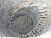
on a hill - This massive palace is situated on NH-76. Archaeological Survey of India is carrying out renovation work in the area. This palace has been declared a monument of national importance. It dates back 16th century AD. - Old wellWater wellA water well is an excavation or structure created in the ground by digging, driving, boring or drilling to access groundwater in underground aquifers. The well water is drawn by an electric submersible pump, a trash pump, a vertical turbine pump, a handpump or a mechanical pump...
with an inscription of Samvat 755 - Large tank in Pathari Kadin
- Large ChandelaChandelaThe Chandela is a Rajput clan found in North India. A section of the Chandelas ruled much of the Bundelkhand region of central India for long periods between the 10th and the 13th centuries AD. The Chandela dynasty is famous in Indian history for King Vidyadhar, who repulsed the attacks of Mahmud...
tank on the embankment on which stands a large ruined temple of the earliest ChandelaChandelaThe Chandela is a Rajput clan found in North India. A section of the Chandelas ruled much of the Bundelkhand region of central India for long periods between the 10th and the 13th centuries AD. The Chandela dynasty is famous in Indian history for King Vidyadhar, who repulsed the attacks of Mahmud...
type - Small temple of which the dome has fallen
Geography
Kulpahar is situated on National Highway No. 76 at a distance of 135 km from JhansiJhansi
Jhansi Hindi:झाँसी, , Marathi: झाशी, is a historical city of India. Jhansi is the administrative headquarters of Jhansi District and Jhansi Division. The original walled city grew up around its stone fort, which crowns a neighboring rock. This district is on the bank of river Betwa.The National...
and 278 km from Allahabad
Allahabad
Allahabad , or Settled by God in Persian, is a major city of India and is one of the main holy cities of Hinduism. It was renamed by the Mughals from the ancient name of Prayaga , and is by some accounts the second-oldest city in India. It is located in the north Indian state of Uttar Pradesh,...
at an altitude of 795 feet (242.3 m) at Latitude 25° 19' N, Longitude 79° 39' E.
Local self government
Kulpahar is governed by a municipality under the Uttar Pradesh Municipal Act. It has 15 member council and the council is chaired by a chairperson who is directly elected by more than 15,000 electorates. The council is called Nagar PalikaNagar Palika
In India, a nagar palika or municipality is a urban local body that administers a city of population 20,000 or more. Under the Panchayati Raj system, it interacts directly with the state government, though it is administratively part of the district it is located in...
Sub district administration
Police administration
- Kulpahar Kotwali
- Belatal (Recently upgraded to a police station from police outpost)
- Ajnar
- Panwari
- Mahobkanth
Water supply
Drinking water supply of the city is managed by Chitrakoot Jalkal Sansthaan's Jaitpur subdivision under Banda division. Water is supplied from a big reservoir Belasagar through lift irrigation to Raja Ka TalRaja Ka Tal
Raja Ka Tal was built by Senapati, the grandson of Maharaja Chhatrasal in 1707 AD. It is locally known as bara tal....
where the Chitrakoot Jalkal Sansthaan has a water filter plant with a capacity of 15,000,000 litre per day.
Fairs and festivals
All the major Indian festivals are celebrated here. The longest of them is festival of navratra and Dussera. Its a 10 days long festival and idols of goddess Durga are placed in many places and day-night long celebrations continues. The festival ends with the immersion of the idols in bara tal lake. Other major festivals are Holi, Diwali, Eid, Christmas and Raksha bandhan.In the month of august and September famous fair of Jalvihar is organized in the city. It is month long celebration. during the opening day of fair idols of all the temples of town are taken out of the temple and a procession takes place.
Cuisine
Typical north Indian food is served and taken everywhere in the town. But a typical bundeli cuisine called "bhata aur gakariya" is very popular here. It is a curry of brinjal and a specially cooked bread. One must taste when s/he visits the place. After food it is must to have dessert so try the famous milk cake at Rahul Restaurant in the main market and Kalakand at Matadin aka Matti halwai's shop. And after you finish your meal don't forget to chew the famous betelBetel
The Betel is the leaf of a vine belonging to the Piperaceae family, which includes pepper and Kava. It is valued both as a mild stimulant and for its medicinal properties...
leaf of Mahoba
Mahoba
Mahoba is a city and Mahoba District of the Indian state of Uttar Pradesh, in the Bundelkhand region. Mahoba is known for its closeness to Khajuraho, Laundi and other historic places like Kulpahar, Charkhari, Kalinjar, Orchha, and Jhansi...
.
Educational institutions
- Government Girls Degree College(Under Construction) - Chief Minister of Uttar Pradesh recently announced the opening of Girls' degree college in Kulpahar. It will offer Bachelor of Arts degree in few subjects initially.
- Jantantra Intermediate College - is affiliated to Uttar Pradesh Board of Secondary Education. It admits students from class 6th till 12th.
- Kulpahar Christian School - is affiliated to Central Board of Secondary Education (CBSE). It admits students from kindergarten till 12th.
- Government Girls High School - is affiliated to Uttar Pradesh Board of Secondary Education. It admits girls students from class 6th till 10th.
- G.B. Islamia Inter College
- Rafique Memorial Junior High School
Government hospitals
- Community Health Center (Civil Hospital) Kulpahar - It is a 30 bed community hospital situated on eastern part of the city on NH-76. This hospital serves to a population of over 3lakh.
- Government Ayurvedic hospital
- Government Homeopathic hospital
Private hospitals
- Janki Nursing Home - It is a 6 bed hospital situated at the centre of the city. It is one of the most prestigious hospital of the area serving people since 1975.
- Shiv Aushadhalaya - It is an ayurvedic hospital serving to the people of Kulpahar since pre-independence era.
- Kulpahar Christian Mission Hospital (Asha Arogya Chikitsalay) - It is a 20 bed hospital run by Protestant Christian missionaries situated on Kulpahar-Nowgong road in the southern part of the city.
National banks
- State Bank of India, Sarrafa Baazaar State Bank of India Website link - This branch is on centralized banking system of State Bank of India.
- Allahabad Bank, Bus Station Allahabad Bank website link
Climate
- Summer - Max. 43 °C, Min. 20 °C
- Winter - Max. 25 °C, Min. 2 °C
- Rainfall: 660 mm (June to September)
- Best Season: August to March
Air
Kulpahar is served by the KhajurahoKhajuraho
The Khajuraho Group of Monuments in Khajuraho , a town in the Indian state of Madhya Pradesh, located in Chhatarpur District, about southeast of New Delhi, are one of the most popular tourist destinations in India. Khajuraho has the largest group of medieval Hindu and Jain temples, famous for...
airport (90 km) and is linked to Mumbai
Mumbai
Mumbai , formerly known as Bombay in English, is the capital of the Indian state of Maharashtra. It is the most populous city in India, and the fourth most populous city in the world, with a total metropolitan area population of approximately 20.5 million...
, Delhi
Delhi
Delhi , officially National Capital Territory of Delhi , is the largest metropolis by area and the second-largest by population in India, next to Mumbai. It is the eighth largest metropolis in the world by population with 16,753,265 inhabitants in the Territory at the 2011 Census...
, Varanasi
Varanasi
-Etymology:The name Varanasi has its origin possibly from the names of the two rivers Varuna and Assi, for the old city lies in the north shores of the Ganga bounded by its two tributaries, the Varuna and the Asi, with the Ganges being to its south...
and Agra
Agra
Agra a.k.a. Akbarabad is a city on the banks of the river Yamuna in the northern state of Uttar Pradesh, India, west of state capital, Lucknow and south from national capital New Delhi. With a population of 1,686,976 , it is one of the most populous cities in Uttar Pradesh and the 19th most...
by Jet Airways
Jet Airways
Jet Airways is a major Indian airline based in Mumbai, Maharashtra. It is India's largest airline and the market leader in the domestic sector. It operates over 400 flights daily to 76 destinations worldwide. Its main hub is Chhatrapati Shivaji International Airport, with secondary hubs at Delhi,...
and Indian Airlines. Other airports in the vicinity are Kanpur (180 km) and Lucknow
Lucknow
Lucknow is the capital city of Uttar Pradesh in India. Lucknow is the administrative headquarters of Lucknow District and Lucknow Division....
(250 km).
Road
National Highway 76 runs through the center of the city. Kulpahar is located in between JhansiJhansi
Jhansi Hindi:झाँसी, , Marathi: झाशी, is a historical city of India. Jhansi is the administrative headquarters of Jhansi District and Jhansi Division. The original walled city grew up around its stone fort, which crowns a neighboring rock. This district is on the bank of river Betwa.The National...
and Allahabad
Allahabad
Allahabad , or Settled by God in Persian, is a major city of India and is one of the main holy cities of Hinduism. It was renamed by the Mughals from the ancient name of Prayaga , and is by some accounts the second-oldest city in India. It is located in the north Indian state of Uttar Pradesh,...
on this highway. Another highway that links Kulpahar is National Highway 74 starts at Kanpur and ends at Sagar in Madhya Pradesh
Madhya Pradesh
Madhya Pradesh , often called the Heart of India, is a state in central India. Its capital is Bhopal and Indore is the largest city....
. There are other highways that link Kulpahar to other parts of the state. Kulpahar also has one bus station and a railway station catering to different routes. Regular bus services are available to nearby towns like Mahoba
Mahoba
Mahoba is a city and Mahoba District of the Indian state of Uttar Pradesh, in the Bundelkhand region. Mahoba is known for its closeness to Khajuraho, Laundi and other historic places like Kulpahar, Charkhari, Kalinjar, Orchha, and Jhansi...
, Banda
Banda
-People:*Banda people, an ethnic group of the Central African Republic, the Democratic Republic of Congo, Cameroon and Sudan*Rupiah Banda, President of Zambia*Hastings Banda, former President of Malawi...
, Nowgaon
Nowgaon
Nowgaon is a city and a municipality in Chhatarpur district in the Indian state of Madhya Pradesh.-Demographics:As of the 2001 India census, Nowgaon had a population of 33,024. Males constitute 54% of the population and females 46%. Nowgaon has an average literacy rate of 72%, higher than the...
, Charkhari
Charkhari
Charkhari, currently a part of Uttar Pradesh state, was one of the Princely states of India during the period of the British Raj. The state was founded by saurabh singh bundela, a Rajput of Bundela clan. On India’s independence, this Princely state was acceded to India.-Geography:Charkhari is...
, Rath
Rath, India
Rath is a city and a municipal board in Hamirpur district in the Indian state of Uttar Pradesh. Rath is a Tehsil of Hamirpur District. It is situted at 506 km. north-south from New Delhi.-History:...
, Orai
Orai
Orai is a city and a municipal board in Jalaun district in the Indian state of Uttar Pradesh. It is the district headquarter for Jalaun District which is part of Jhansi division....
, Chitrakoot, Karwi
Karwi
Karwi is a town in Chitrakoot district of Uttar Pradesh in India. Before the Sepoy Mutiny it was the residence of a Maratha noble, whose accumulations constituted the treasure afterwards famously known as the Kirwee and Banda Prize Money. It comes under the Karwi tehsil. The town has its own...
, Hamirpur
Hamirpur, Uttar Pradesh
Hamirpur is a city and a municipal board in Hamirpur district in the Indian state of Uttar Pradesh. It is the administrative headquarters of Hamirpur District.-Geography:...
and Kulpahar is also well connected with bus services to Allahabad
Allahabad
Allahabad , or Settled by God in Persian, is a major city of India and is one of the main holy cities of Hinduism. It was renamed by the Mughals from the ancient name of Prayaga , and is by some accounts the second-oldest city in India. It is located in the north Indian state of Uttar Pradesh,...
, Varanasi
Varanasi
-Etymology:The name Varanasi has its origin possibly from the names of the two rivers Varuna and Assi, for the old city lies in the north shores of the Ganga bounded by its two tributaries, the Varuna and the Asi, with the Ganges being to its south...
, Kanpur, Lucknow
Lucknow
Lucknow is the capital city of Uttar Pradesh in India. Lucknow is the administrative headquarters of Lucknow District and Lucknow Division....
, Delhi
Delhi
Delhi , officially National Capital Territory of Delhi , is the largest metropolis by area and the second-largest by population in India, next to Mumbai. It is the eighth largest metropolis in the world by population with 16,753,265 inhabitants in the Territory at the 2011 Census...
, Agra
Agra
Agra a.k.a. Akbarabad is a city on the banks of the river Yamuna in the northern state of Uttar Pradesh, India, west of state capital, Lucknow and south from national capital New Delhi. With a population of 1,686,976 , it is one of the most populous cities in Uttar Pradesh and the 19th most...
, Jhansi
Jhansi
Jhansi Hindi:झाँसी, , Marathi: झाशी, is a historical city of India. Jhansi is the administrative headquarters of Jhansi District and Jhansi Division. The original walled city grew up around its stone fort, which crowns a neighboring rock. This district is on the bank of river Betwa.The National...
, Jaipur
Jaipur
Jaipur , also popularly known as the Pink City, is the capital and largest city of the Indian state of Rajasthan. Founded on 18 November 1727 by Maharaja Sawai Jai Singh II, the ruler of Amber, the city today has a population of more than 3.1 million....
and Ajmer
Ajmer
Ajmer , formerly written as Ajmere, is a city in Ajmer District in Rajasthan state in India. Ajmer has a population of around 800,000 , and is located west of the Rajasthan state capital Jaipur, 200 km from Jodhpur, 274 km from Udaipur, 439 km from Jaisalmer, and 391 km from...
.
Tourist taxis, auto-rickshaws and tempos are available for local transport. But the cheapest and most efficient method of local transport is the Tonga. Rates are not fixed and one needs to bargain.
Rail
Kulpahar is a railway station of the North Central Railways Zone, and is well connected by trains with all major cities, namely, KolkataKolkata
Kolkata , formerly known as Calcutta, is the capital of the Indian state of West Bengal. Located on the east bank of the Hooghly River, it was the commercial capital of East India...
, Delhi
Delhi
Delhi , officially National Capital Territory of Delhi , is the largest metropolis by area and the second-largest by population in India, next to Mumbai. It is the eighth largest metropolis in the world by population with 16,753,265 inhabitants in the Territory at the 2011 Census...
, Mumbai
Mumbai
Mumbai , formerly known as Bombay in English, is the capital of the Indian state of Maharashtra. It is the most populous city in India, and the fourth most populous city in the world, with a total metropolitan area population of approximately 20.5 million...
, Jhansi
Jhansi
Jhansi Hindi:झाँसी, , Marathi: झाशी, is a historical city of India. Jhansi is the administrative headquarters of Jhansi District and Jhansi Division. The original walled city grew up around its stone fort, which crowns a neighboring rock. This district is on the bank of river Betwa.The National...
, Varanasi
Varanasi
-Etymology:The name Varanasi has its origin possibly from the names of the two rivers Varuna and Assi, for the old city lies in the north shores of the Ganga bounded by its two tributaries, the Varuna and the Asi, with the Ganges being to its south...
, Agra
Agra
Agra a.k.a. Akbarabad is a city on the banks of the river Yamuna in the northern state of Uttar Pradesh, India, west of state capital, Lucknow and south from national capital New Delhi. With a population of 1,686,976 , it is one of the most populous cities in Uttar Pradesh and the 19th most...
, Gwalior, Jabalpur, Gaya
Gaya, India
Gaya is the second largest city of Bihar, India, and it is also the headquarters of Gaya District.Gaya is 100 kilometers south of Patna, the capital city of Bihar. Situated on the banks of Falgu River , it is a place sanctified by both the Hindu and the Buddhist religions...
, Mathura and Allahabad
Allahabad
Allahabad , or Settled by God in Persian, is a major city of India and is one of the main holy cities of Hinduism. It was renamed by the Mughals from the ancient name of Prayaga , and is by some accounts the second-oldest city in India. It is located in the north Indian state of Uttar Pradesh,...
.
Major Trains connecting Kulpahar with rest of the country are 1107/1108 Bundelkhand Exp, 2175/2176 Gwalior-Howrah Chambal Exp, 2177/2178 Mathura-Howrah Chambal Exp, 2189/2190 Mahakoshal Exp, 1069/1070 Tulsi Exp and 2447/2448 Uttar Pradesh Sampark Kranti Exp.
Granite mining in Kulpahar
Rock (geology)
In geology, rock or stone is a naturally occurring solid aggregate of minerals and/or mineraloids.The Earth's outer solid layer, the lithosphere, is made of rock. In general rocks are of three types, namely, igneous, sedimentary, and metamorphic...
and black dolerite. The rocks are generally medium to coarse to very coarse grained, having variegated colours with varying textural patterns. In geological nomenclature they can be classified on the basis of colour, grain size and texture. Over half of the areas identified so far appear suitable for extracting blocks of two cubic meters in size from the surface outcrops. The granite with red feldspar
Feldspar
Feldspars are a group of rock-forming tectosilicate minerals which make up as much as 60% of the Earth's crust....
having presence of white and bluish quartz
Quartz
Quartz is the second-most-abundant mineral in the Earth's continental crust, after feldspar. It is made up of a continuous framework of SiO4 silicon–oxygen tetrahedra, with each oxygen being shared between two tetrahedra, giving an overall formula SiO2. There are many different varieties of quartz,...
has caught the fancy of buyers and has become quite popular in national and international markets during the last 10 years, The remaining outcrops would be suited for blocks of smaller size. Ruby red granite
Granite
Granite is a common and widely occurring type of intrusive, felsic, igneous rock. Granite usually has a medium- to coarse-grained texture. Occasionally some individual crystals are larger than the groundmass, in which case the texture is known as porphyritic. A granitic rock with a porphyritic...
is good in quality and is very popular in national and international markets, In granitic terrain
Terrain
Terrain, or land relief, is the vertical and horizontal dimension of land surface. When relief is described underwater, the term bathymetry is used...
the rocks may occur in the form of widespread sheets exposed above the ground level, in the form of hillocks, as high ground or below the ground under soil cover. They may also occur as boulders of different size and shapes spread over the sheet rock. They may be found as dykes, particularly of black and green types, as long narrow ridge
Ridge
A ridge is a geological feature consisting of a chain of mountains or hills that form a continuous elevated crest for some distance. Ridges are usually termed hills or mountains as well, depending on size. There are several main types of ridges:...
s often concealed beneath the surface. A major part of granite deposits in these regions are underground and have to be extracted by open cast mining. Underground granite block is more compact and require sophisticated and specialised machinery which adds to the cost of mining
Mining
Mining is the extraction of valuable minerals or other geological materials from the earth, from an ore body, vein or seam. The term also includes the removal of soil. Materials recovered by mining include base metals, precious metals, iron, uranium, coal, diamonds, limestone, oil shale, rock...
.
Historical
- AjaigarhAjaigarhAjaigarh, or Adjygurh is town and a nagar panchayat in the Panna District of Madhya Pradesh state in central India.-History:Ajaigarh was the capital of a princely state of the same name during the British Raj. Ajaigarh was founded in 1765 by Guman Singh, a Bundela Rajput who was the nephew of Raja...
: 100 km south-west of the city. - CharkhariCharkhariCharkhari, currently a part of Uttar Pradesh state, was one of the Princely states of India during the period of the British Raj. The state was founded by saurabh singh bundela, a Rajput of Bundela clan. On India’s independence, this Princely state was acceded to India.-Geography:Charkhari is...
: 15 km north of the city. - JhansiJhansiJhansi Hindi:झाँसी, , Marathi: झाशी, is a historical city of India. Jhansi is the administrative headquarters of Jhansi District and Jhansi Division. The original walled city grew up around its stone fort, which crowns a neighboring rock. This district is on the bank of river Betwa.The National...
: 135 km west of the city. - KalinjarKalinjarKalinjar is a fortress-city in the Bundelkhand region of central India. Kalinjar is located in Banda District of Uttar Pradesh state, near the temple-city and World Heritage Site of Khajuraho. The fortress is strategically located on an isolated rocky hill at the end the Vindhya Range, at an...
: 150 km east-south of the city. - KalpiKalpiKalpi is a city and a municipal board in Jalaun district in the Indian state of Uttar Pradesh. It is on the right bank of the Yamuna.-History:...
: 140 km north-west of the city. - KhajurahoKhajurahoThe Khajuraho Group of Monuments in Khajuraho , a town in the Indian state of Madhya Pradesh, located in Chhatarpur District, about southeast of New Delhi, are one of the most popular tourist destinations in India. Khajuraho has the largest group of medieval Hindu and Jain temples, famous for...
: 80 km south-east of the city. - MahobaMahobaMahoba is a city and Mahoba District of the Indian state of Uttar Pradesh, in the Bundelkhand region. Mahoba is known for its closeness to Khajuraho, Laundi and other historic places like Kulpahar, Charkhari, Kalinjar, Orchha, and Jhansi...
: 25 km east of the city. - Rath, IndiaRath, IndiaRath is a city and a municipal board in Hamirpur district in the Indian state of Uttar Pradesh. Rath is a Tehsil of Hamirpur District. It is situted at 506 km. north-south from New Delhi.-History:...
42 km north-west of the city - SugiraSugiraSugira, formerly known as Kunwarpur, is a village in India. It lies between Kulpahar and Rath on National Highway 76 4 km from Kulpahar towards Jhansi. Sugira was counted as a model village before 1980....
: 4 km west of the city
Natural
- PannaPanna, IndiaPanna is a city and a municipality in Panna district in the Indian state of Madhya Pradesh. It is famous for its diamond mines. It is the administrative center of Panna District.- History :...
: 120 km south-east of the city. - Pandav falls: 80 km south-east of the city.
- Raneh falls: 85 km south-west of the city.
- Matatila damMatatila DamThe Matatila Dam, is a dam in India that was built in 1958 on the Betwa River. Situated 93 km away from Deogarh, this earthen dam is 35 m high. The catchment area is around 20 km2 with a maximum storage capacity of 1132 million cubic metres. Nestled between a large numbers of small hills, this...
: 135 km west-south of the city. - Parichha damParichha DamParichha Dam, built on the Betwa River near Parichha town, which is about 25 km from Jhansi on the Jhansi-Kanpur National Highway No. 25. Its reservoir - a placid stretch of water that runs to Notghat Bridge, 34 km away from Jhansi - is ideal for water sports.-References:...
: 135 km west of the city. - Baruasagar damBarua Sagar TalBarua Sagar Tal is a large lake situated in Barua Sagar near Jhansi in the Indian state of Uttar Pradesh.-History:It is a large lake and it was created about 260 years ago by Raja Udit Singh of Orchha, who built the embankment....
: 115 km west of the city.
Religious
- Chitrakoot: 150 km east of the city.
- OrchhaOrchhaOrchha is a town in Tikamgarh district of Madhya Pradesh state, India. The town was established by Maharaja Rudra Pratap Singh in 1501, as the seat of an eponymous former princely state of central India, in the Bundelkhand region. Orchha lies on the Betwa River , 80 km from Tikamgarh &...
: 125 km west of the city. - DeogarhDeogarh, Uttar PradeshDeogarh is a small farming village near the town of Lalitpur in Lalitpur district, in the state of Uttar Pradesh, India. Located at the border with the former princely state of Gwalior, which is now part of Madhya Pradesh, it is known for its Gupta monuments, located on and near the hill fort on...
: 145 km west-south of the city.
Museum
- Madhya Pradesh State museum DhubelaDhubelaMaharaja Chhatrasal Museum is a museum located in an old palace at Dhubela, on the Chhatarpur-Nowgaon highway, in Chhatarpur District, Madhya Pradesh, India. This museum was established in September, 1955 in a palace built by Chhatrasal...
, NowgaonNowgaonNowgaon is a city and a municipality in Chhatarpur district in the Indian state of Madhya Pradesh.-Demographics:As of the 2001 India census, Nowgaon had a population of 33,024. Males constitute 54% of the population and females 46%. Nowgaon has an average literacy rate of 72%, higher than the... - Bundelkhand Chhatrasal Museum, Banda
- Rani Jhansi Museum, JhansiJhansiJhansi Hindi:झाँसी, , Marathi: झाशी, is a historical city of India. Jhansi is the administrative headquarters of Jhansi District and Jhansi Division. The original walled city grew up around its stone fort, which crowns a neighboring rock. This district is on the bank of river Betwa.The National...
Demographics
India censusCensus
A census is the procedure of systematically acquiring and recording information about the members of a given population. It is a regularly occurring and official count of a particular population. The term is used mostly in connection with national population and housing censuses; other common...
, Kulpahar had a population of 17,437. Males constitute 52% of the population and females 48%. Kulpahar has an average literacy rate of 65.50%, higher than the national average of 59.5%. In Kulpahar, 18% of the population is under 6 years of age.
- Total Population : 17,437
- Male : 9,108
- Female : 8,329
- Population 0-6 (Total) : 3,184
- Male : 1,681
- Female : 1,503
- Literates (Total) : 9,426
- Male : 5,893
- Female : 3,533