
Jiuzhaigou Valley
Encyclopedia
Jiuzhaigou Valley is a nature reserve
and national park located in the Aba Tibetan Qiang Autonomous Prefecture of Sichuan
Province, Southwestern China.
Jiuzhaigou Valley is part of the Min Shan mountain range
on the edge of the Tibetan Himalayan Plateau and stretches over 72,000 hectares. It is known for its many multi-level waterfall
s, colorful lake
s, and snow-capped peaks. Its elevation ranges from 2,000 m to 4,500 m.
Jiuzhaigou Valley was inscribed by UNESCO
as a World Heritage Site
in 1992 and a World Biosphere Reserve
in 1997. It belongs to the category V (Protected Landscape) in the IUCN system of protected area categorization.
villages along its length.
The remote region was inhabited by various Tibetan and Qiang peoples for centuries. Until 1975 this inaccessible area was little known. Extensive logging
took place until 1979, when the Chinese government
banned such activity and made the area a national park
in 1982. An Administration Bureau was established and the site officially opened to tourism in 1984; layout of facilities and regulations were completed in 1987.
The site was inscribed by UNESCO
as a World Heritage Site
in 1992 and a World Biosphere Reserve
in 1997.
Since opening, tourist activity has increased every year: from 5,000 in 1984 to 170,000 in 1991, 160,000 in 1995, to 200,000 in 1997, including about 3,000 foreigners. Visitors numbered 1,190,000 in 2002. , the site averages 7,000 visits per day, with a quota of 12,000 being reportedly enforced during high season. The Town of Zhangzha at the exit of the valley and the nearby Songpan County feature an ever-increasing number of hotels, including several luxury five-stars
, such as Sheraton
.
Developments related to mass tourism in the region have caused concerns about the impact on the environment around the park.
Penbu, Panxing and Yongzhu villages lie along the road that passes through the town of Jiuzhaigou/Zhangza outside the valley.
In 2003, the permanent population of the valley was about 1,000 comprising 112 families, and due to the protected nature of the park, agriculture is no longer permitted so the locals now rely on tourism and local government subsidies to make a living.
, 330 km (205 mi) north of the provincial capital of Chengdu
. It is part of the Jiuzhaigou County
(formerly Nanping County) in the Aba Tibetan Qiang Autonomous Prefecture of northwestern Sichuan
province, near the Gansu
border.
The valley covers 720 km² (278 sq mi), with buffer zone
s covering an additional 600 km² (232 sq mi). Its elevation
, depending on the area considered, ranges from 1,998 to 2,140 m (at the mouth of Shuzheng Gully) to 4,558-4,764 m (on Mount Ganzigonggai at the top of Zechawa Gully).
The climate is subtropical to temperate
monsoon with a mean annual temperature of 7.8 °C, with means of -3.7 °C in January and 16.8 °C in July. Total annual rainfall is 761 mm but in the cloud forest it is at least 1,000 mm. 80% of rainfall occurs between May and October.
is classified as temperate broad-leaf forest and woodlands, with mixed mountain and highland systems. Nearly 300 km² (116 sq mi) of the core scenic area are covered by virgin mixed forests. Those forests take on attractive yellow, orange and red hues in the autumn, making that season a popular one for visitors. They are home to a number of plant species of interest, such as endemic varieties of rhododendron
and bamboo
.
Local fauna includes the endangered
giant panda
and golden snub-nosed monkey
. Both populations are very small (less than 20 individuals for the pandas) and isolated. Their survival is in question in a valley subject to increasing tourism. Jiuzhaigou is also home to approximately 140 bird species.
s shaped by glacial
, hydrological
and tectonic
activity. It lies on major faultlines on the diverging belt between the Qinghai-Tibet Plate and the Yangtze Plate, and earthquake
s have also shaped the landscape. The rock strata
is mostly made up of carbonate
rocks such dolomite
and tufa
, as well as some sandstone
and shale
s.
The valley includes the catchment area of three gullies
(which due to their large size are often called valley
s themselves), and is one of the sources of the Jialing River
, part of the Yangtze River
system.
Jiuzhaigou's best-known feature is its dozens of blue, green and turquoise-colored lakes. The local Tibetan people call them "Haizi" in Chinese, meaning "son of the sea". Originating in glacial activity, they were dammed by rockfalls and other natural phenomena, then solidified by processes of carbonate deposition. Some lakes have a high concentration of calcium carbonate
, and their water is very clear so that the bottom is often visible even at high depths. The lakes vary in color and aspect according to their depths, residues, and surroundings.
Some of the less stable dams and formations have been artificially reinforced, and direct contact with the lakes or other features is forbidden to tourists.
of these gullies are lined with 55 km (34 mi) of roads for shuttle buses, as well as wooden boardwalk
s and small pavilions. The boardwalks are typically located on the opposite side of the lakes from the road, shielding them from disturbance by passing buses.
Most visitors will first take the shuttle bus to the end of Rize and/or Shuzheng gully, then make their way back downhill by foot on the boardwalks, taking the bus instead when the next site is too distant. Here is a summary of the sites found in each of the gullies:
: Rìzé Gōu) is the south-western branch of Jiuzhaigou. It contains the largest variety of sites and is typically visited first. Going downhill from its highest point, one passes the following sites:
and ends at the Red, Black, and Daling lakes.
Zharu Valley is the home of eco-tourism in Jiuzhaigou. The valley has recently been opened to a small number of ecotourists wishing to go hiking and camping off the beaten track. Visitors can choose from day walks and multiple day hikes, depending on their time availability. Knowledgeable guides accompany ecotourists through the valley, sharing their knowledge about the unique biodiversity and local culture of the national park. The Zharu Valley has 40% of all the plant species that exist in China and it is the best place to spot wildlife inside the national park.
The main hike follows the pilgrimage of the local Benbo Buddhists circumnavigating the sacred 4,528 m Zha Yi Zha Ga Mountain.
, prone to occasional minor rockslides and in the rainy season, mudslides that can add several hours to the trip. The new highway that had been constructed along this route was badly damaged during the May 12th 2008 earthquake but has now been repaired. Further repairs from Mao Xian to Chuan Zhu Si are still ongoing but the road is open to public buses and private vehicles.
Since 2003, it has been possible to fly from Chengdu
or Chongqing
to Jiuzhaigou Huanglong Airport
on a 11311 ft (3,448 m) high mountain side near Songpan County, and then take an hour-long bus ride to Huanglong, or a 90-minute bus ride to Jiuzhaigou. From 2006, a daily flight to Xi'an
had been opened in peak season and new flights are being added all the time from different parts of China. In October 2009 new direct flights were added from Beijing, Shanghai and Hangzhou
. Jiuzhaigou or Huanglong National Parks did not experience any damage during the earthquake of May 2008 and never closed after the event.
Related lists
Other links
Nature reserve
A nature reserve is a protected area of importance for wildlife, flora, fauna or features of geological or other special interest, which is reserved and managed for conservation and to provide special opportunities for study or research...
and national park located in the Aba Tibetan Qiang Autonomous Prefecture of Sichuan
Sichuan
' , known formerly in the West by its postal map spellings of Szechwan or Szechuan is a province in Southwest China with its capital in Chengdu...
Province, Southwestern China.
Jiuzhaigou Valley is part of the Min Shan mountain range
Min Mountains
Min Mountains or Minshan are a mountain range in central China. It runs in the general north-south direction through northern Sichuan and southernmost borderlands of Gansu...
on the edge of the Tibetan Himalayan Plateau and stretches over 72,000 hectares. It is known for its many multi-level waterfall
Waterfall
A waterfall is a place where flowing water rapidly drops in elevation as it flows over a steep region or a cliff.-Formation:Waterfalls are commonly formed when a river is young. At these times the channel is often narrow and deep. When the river courses over resistant bedrock, erosion happens...
s, colorful lake
Lake
A lake is a body of relatively still fresh or salt water of considerable size, localized in a basin, that is surrounded by land. Lakes are inland and not part of the ocean and therefore are distinct from lagoons, and are larger and deeper than ponds. Lakes can be contrasted with rivers or streams,...
s, and snow-capped peaks. Its elevation ranges from 2,000 m to 4,500 m.
Jiuzhaigou Valley was inscribed by UNESCO
UNESCO
The United Nations Educational, Scientific and Cultural Organization is a specialized agency of the United Nations...
as a World Heritage Site
World Heritage Site
A UNESCO World Heritage Site is a place that is listed by the UNESCO as of special cultural or physical significance...
in 1992 and a World Biosphere Reserve
Biosphere reserve
The Man and the Biosphere Programme of UNESCO was established in 1971 to promote interdisciplinary approaches to management, research and education in ecosystem conservation and sustainable use of natural resources.-Development:...
in 1997. It belongs to the category V (Protected Landscape) in the IUCN system of protected area categorization.
History
Jiuzhaigou (literally "Nine Village Valley") takes its name from the nine TibetanTibetan people
The Tibetan people are an ethnic group that is native to Tibet, which is mostly in the People's Republic of China. They number 5.4 million and are the 10th largest ethnic group in the country. Significant Tibetan minorities also live in India, Nepal, and Bhutan...
villages along its length.
The remote region was inhabited by various Tibetan and Qiang peoples for centuries. Until 1975 this inaccessible area was little known. Extensive logging
Logging
Logging is the cutting, skidding, on-site processing, and loading of trees or logs onto trucks.In forestry, the term logging is sometimes used in a narrow sense concerning the logistics of moving wood from the stump to somewhere outside the forest, usually a sawmill or a lumber yard...
took place until 1979, when the Chinese government
Government of the People's Republic of China
All power within the government of the People's Republic of China is divided among three bodies: the People's Republic of China, State Council, and the People's Liberation Army . This article is concerned with the formal structure of the state, its departments and their responsibilities...
banned such activity and made the area a national park
National park
A national park is a reserve of natural, semi-natural, or developed land that a sovereign state declares or owns. Although individual nations designate their own national parks differently A national park is a reserve of natural, semi-natural, or developed land that a sovereign state declares or...
in 1982. An Administration Bureau was established and the site officially opened to tourism in 1984; layout of facilities and regulations were completed in 1987.
The site was inscribed by UNESCO
UNESCO
The United Nations Educational, Scientific and Cultural Organization is a specialized agency of the United Nations...
as a World Heritage Site
World Heritage Site
A UNESCO World Heritage Site is a place that is listed by the UNESCO as of special cultural or physical significance...
in 1992 and a World Biosphere Reserve
Biosphere reserve
The Man and the Biosphere Programme of UNESCO was established in 1971 to promote interdisciplinary approaches to management, research and education in ecosystem conservation and sustainable use of natural resources.-Development:...
in 1997.
Since opening, tourist activity has increased every year: from 5,000 in 1984 to 170,000 in 1991, 160,000 in 1995, to 200,000 in 1997, including about 3,000 foreigners. Visitors numbered 1,190,000 in 2002. , the site averages 7,000 visits per day, with a quota of 12,000 being reportedly enforced during high season. The Town of Zhangzha at the exit of the valley and the nearby Songpan County feature an ever-increasing number of hotels, including several luxury five-stars
Star (classification)
Stars are often used as symbols for classification purposes. They are used by reviewers for ranking things such as movies, TV shows, restaurants, and hotels. For example, one to five stars is commonly employed to categorize hotels.-Restaurant ratings:...
, such as Sheraton
Sheraton Hotels and Resorts
Sheraton Hotels and Resorts is Starwood Hotels & Resorts Worldwide's largest and second oldest brand . Starwood's headquarters are in White Plains, New York.-Sheraton history:...
.
Developments related to mass tourism in the region have caused concerns about the impact on the environment around the park.
Population
Seven of the nine Tibetan villages are still populated today. The main agglomerations that are readily accessible to tourists are Heye, Shuzheng and Zechawa along the main paths that cater to tourists, selling various handicrafts, souvenirs and snacks. There is also Rexi in the smaller Zaru Valley and behind Heye village are Jianpan, Panya and Yana villages. Guodu and Hejiao villages are no longer populated.Penbu, Panxing and Yongzhu villages lie along the road that passes through the town of Jiuzhaigou/Zhangza outside the valley.
In 2003, the permanent population of the valley was about 1,000 comprising 112 families, and due to the protected nature of the park, agriculture is no longer permitted so the locals now rely on tourism and local government subsidies to make a living.
Geography and climate
Jiuzhaigou lies at the southern end of the Minshan mountain rangeMountain range
A mountain range is a single, large mass consisting of a succession of mountains or narrowly spaced mountain ridges, with or without peaks, closely related in position, direction, formation, and age; a component part of a mountain system or of a mountain chain...
, 330 km (205 mi) north of the provincial capital of Chengdu
Chengdu
Chengdu , formerly transliterated Chengtu, is the capital of Sichuan province in Southwest China. It holds sub-provincial administrative status...
. It is part of the Jiuzhaigou County
Jiuzhaigou County
Jiuzhaigou County is a county of Sichuan Province, China. It is under the administration of the Ngawa Tibetan and Qiang Autonomous Prefecture. Formerly called Nanping County , it was renamed in 1998 to reflect the fact that the Jiuzhaigou Valley is located within its administration.The county...
(formerly Nanping County) in the Aba Tibetan Qiang Autonomous Prefecture of northwestern Sichuan
Sichuan
' , known formerly in the West by its postal map spellings of Szechwan or Szechuan is a province in Southwest China with its capital in Chengdu...
province, near the Gansu
Gansu
' is a province located in the northwest of the People's Republic of China.It lies between the Tibetan and Huangtu plateaus, and borders Mongolia, Inner Mongolia, and Ningxia to the north, Xinjiang and Qinghai to the west, Sichuan to the south, and Shaanxi to the east...
border.
The valley covers 720 km² (278 sq mi), with buffer zone
Buffer zone
A buffer zone is generally a zonal area that lies between two or more other areas , but depending on the type of buffer zone, the reason for it may be to segregate regions or to conjoin them....
s covering an additional 600 km² (232 sq mi). Its elevation
Elevation
The elevation of a geographic location is its height above a fixed reference point, most commonly a reference geoid, a mathematical model of the Earth's sea level as an equipotential gravitational surface ....
, depending on the area considered, ranges from 1,998 to 2,140 m (at the mouth of Shuzheng Gully) to 4,558-4,764 m (on Mount Ganzigonggai at the top of Zechawa Gully).
The climate is subtropical to temperate
Temperate
In geography, temperate or tepid latitudes of the globe lie between the tropics and the polar circles. The changes in these regions between summer and winter are generally relatively moderate, rather than extreme hot or cold...
monsoon with a mean annual temperature of 7.8 °C, with means of -3.7 °C in January and 16.8 °C in July. Total annual rainfall is 761 mm but in the cloud forest it is at least 1,000 mm. 80% of rainfall occurs between May and October.
Ecology
Jiuzhaigou's ecosystemEcosystem
An ecosystem is a biological environment consisting of all the organisms living in a particular area, as well as all the nonliving , physical components of the environment with which the organisms interact, such as air, soil, water and sunlight....
is classified as temperate broad-leaf forest and woodlands, with mixed mountain and highland systems. Nearly 300 km² (116 sq mi) of the core scenic area are covered by virgin mixed forests. Those forests take on attractive yellow, orange and red hues in the autumn, making that season a popular one for visitors. They are home to a number of plant species of interest, such as endemic varieties of rhododendron
Rhododendron
Rhododendron is a genus of over 1 000 species of woody plants in the heath family, most with showy flowers...
and bamboo
Bamboo
Bamboo is a group of perennial evergreens in the true grass family Poaceae, subfamily Bambusoideae, tribe Bambuseae. Giant bamboos are the largest members of the grass family....
.
Local fauna includes the endangered
Endangered species
An endangered species is a population of organisms which is at risk of becoming extinct because it is either few in numbers, or threatened by changing environmental or predation parameters...
giant panda
Giant Panda
The giant panda, or panda is a bear native to central-western and south western China. It is easily recognized by its large, distinctive black patches around the eyes, over the ears, and across its round body. Though it belongs to the order Carnivora, the panda's diet is 99% bamboo...
and golden snub-nosed monkey
Snub-nosed monkey
Snub-nosed monkeys are a group of Old World monkeys and make up the entirety of the genus Rhinopithecus. The genus occurs rarely and needs much more research...
. Both populations are very small (less than 20 individuals for the pandas) and isolated. Their survival is in question in a valley subject to increasing tourism. Jiuzhaigou is also home to approximately 140 bird species.
Geology and hydrology
Jiuzhaigou's landscape is made up of high-altitude karstKARST
Kilometer-square Area Radio Synthesis Telescope is a Chinese telescope project to which FAST is a forerunner. KARST is a set of large spherical reflectors on karst landforms, which are bowlshaped limestone sinkholes named after the Kras region in Slovenia and Northern Italy. It will consist of...
s shaped by glacial
Glacier
A glacier is a large persistent body of ice that forms where the accumulation of snow exceeds its ablation over many years, often centuries. At least 0.1 km² in area and 50 m thick, but often much larger, a glacier slowly deforms and flows due to stresses induced by its weight...
, hydrological
Hydrology
Hydrology is the study of the movement, distribution, and quality of water on Earth and other planets, including the hydrologic cycle, water resources and environmental watershed sustainability...
and tectonic
Tectonics
Tectonics is a field of study within geology concerned generally with the structures within the lithosphere of the Earth and particularly with the forces and movements that have operated in a region to create these structures.Tectonics is concerned with the orogenies and tectonic development of...
activity. It lies on major faultlines on the diverging belt between the Qinghai-Tibet Plate and the Yangtze Plate, and earthquake
Earthquake
An earthquake is the result of a sudden release of energy in the Earth's crust that creates seismic waves. The seismicity, seismism or seismic activity of an area refers to the frequency, type and size of earthquakes experienced over a period of time...
s have also shaped the landscape. The rock strata
Stratum
In geology and related fields, a stratum is a layer of sedimentary rock or soil with internally consistent characteristics that distinguish it from other layers...
is mostly made up of carbonate
Carbonate
In chemistry, a carbonate is a salt of carbonic acid, characterized by the presence of the carbonate ion, . The name may also mean an ester of carbonic acid, an organic compound containing the carbonate group C2....
rocks such dolomite
Dolomite
Dolomite is a carbonate mineral composed of calcium magnesium carbonate CaMg2. The term is also used to describe the sedimentary carbonate rock dolostone....
and tufa
Tufa
Tufa is a variety of limestone, formed by the precipitation of carbonate minerals from ambient temperature water bodies. Geothermally heated hot-springs sometimes produce similar carbonate deposits known as travertine...
, as well as some sandstone
Sandstone
Sandstone is a sedimentary rock composed mainly of sand-sized minerals or rock grains.Most sandstone is composed of quartz and/or feldspar because these are the most common minerals in the Earth's crust. Like sand, sandstone may be any colour, but the most common colours are tan, brown, yellow,...
and shale
Shale
Shale is a fine-grained, clastic sedimentary rock composed of mud that is a mix of flakes of clay minerals and tiny fragments of other minerals, especially quartz and calcite. The ratio of clay to other minerals is variable. Shale is characterized by breaks along thin laminae or parallel layering...
s.
The valley includes the catchment area of three gullies
Gully
A gully is a landform created by running water, eroding sharply into soil, typically on a hillside. Gullies resemble large ditches or small valleys, but are metres to tens of metres in depth and width...
(which due to their large size are often called valley
Valley
In geology, a valley or dale is a depression with predominant extent in one direction. A very deep river valley may be called a canyon or gorge.The terms U-shaped and V-shaped are descriptive terms of geography to characterize the form of valleys...
s themselves), and is one of the sources of the Jialing River
Jialing River
The Jialing River is a tributary of the Yangtze River with its source in Gansu province. It gets its name from its crossing the Jialing Vale in Feng County of Shaanxi. It was once known as Langshui or Yushui .-Overview:...
, part of the Yangtze River
Yangtze River
The Yangtze, Yangzi or Cháng Jiāng is the longest river in Asia, and the third-longest in the world. It flows for from the glaciers on the Tibetan Plateau in Qinghai eastward across southwest, central and eastern China before emptying into the East China Sea at Shanghai. It is also one of the...
system.
Jiuzhaigou's best-known feature is its dozens of blue, green and turquoise-colored lakes. The local Tibetan people call them "Haizi" in Chinese, meaning "son of the sea". Originating in glacial activity, they were dammed by rockfalls and other natural phenomena, then solidified by processes of carbonate deposition. Some lakes have a high concentration of calcium carbonate
Calcium carbonate
Calcium carbonate is a chemical compound with the formula CaCO3. It is a common substance found in rocks in all parts of the world, and is the main component of shells of marine organisms, snails, coal balls, pearls, and eggshells. Calcium carbonate is the active ingredient in agricultural lime,...
, and their water is very clear so that the bottom is often visible even at high depths. The lakes vary in color and aspect according to their depths, residues, and surroundings.
Some of the less stable dams and formations have been artificially reinforced, and direct contact with the lakes or other features is forbidden to tourists.
Notable features
Jiuzhaigou is composed of three valleys arranged in a Y shape. The Rize and Zechawa valleys flow from the south and meet at the centre of the site where they form the Shuzheng valley, flowing north to the mouth of the valley. The mountainous watershedsDrainage basin
A drainage basin is an extent or an area of land where surface water from rain and melting snow or ice converges to a single point, usually the exit of the basin, where the waters join another waterbody, such as a river, lake, reservoir, estuary, wetland, sea, or ocean...
of these gullies are lined with 55 km (34 mi) of roads for shuttle buses, as well as wooden boardwalk
Boardwalk
A boardwalk, in the conventional sense, is a wooden walkway for pedestrians and sometimes vehicles, often found along beaches, but they are also common as paths through wetlands, coastal dunes, and other sensitive environments....
s and small pavilions. The boardwalks are typically located on the opposite side of the lakes from the road, shielding them from disturbance by passing buses.
Most visitors will first take the shuttle bus to the end of Rize and/or Shuzheng gully, then make their way back downhill by foot on the boardwalks, taking the bus instead when the next site is too distant. Here is a summary of the sites found in each of the gullies:
Rize Valley
The 18 km (11 mi) long Rize Valley (日则沟, pinyinPinyin
Pinyin is the official system to transcribe Chinese characters into the Roman alphabet in China, Malaysia, Singapore and Taiwan. It is also often used to teach Mandarin Chinese and spell Chinese names in foreign publications and used as an input method to enter Chinese characters into...
: Rìzé Gōu) is the south-western branch of Jiuzhaigou. It contains the largest variety of sites and is typically visited first. Going downhill from its highest point, one passes the following sites:
- The Primeval Forest (原始森林 Yuánshǐ Sēnlín) is a preserved ancient woodland. It is fronted by spectacular views of the surrounding mountains and cliffs, including the 500 m high blade-shaped Sword Rock (剑岩 Jiàn Yán).
- Swan Lake (天鹅海, Tiān'é Hǎi) is a 2250 m long, 125 m wide picturesque lake named for its visiting swans and ducks.
- Grass Lake (草海, Cǎo Hǎi) is a shallow lake covered in intricate vegetation patterns.
- Arrow Bamboo Lake (箭竹海, Jiànzhú Hǎi), covering an area of 170,000 m², is a shallow lake with a depth of 6 m. It lies at an elevation of 2,618 m, and was a main feature site for the 2002 Chinese film Hero.
- Panda Lake (熊猫海, Xióngmāo Hǎi) features curious color patterns of blue and green. Giant Pandas were said to have come to this lake to drink, though there have been no sightings for many years. The lake empties into the multi-stream, multi-level Panda Waterfalls, dropping 78 m in three steps.
- Five Flower Lake (五花海, Wǔhuā Hǎi) is a shallow multi-colored lake whose bottom is criss-crossed by ancient fallen tree trunks.
- Pearl Shoal (珍珠滩, Zhēnzhū Tān) is a wide, gently sloping area of active calcareous tufaTufaTufa is a variety of limestone, formed by the precipitation of carbonate minerals from ambient temperature water bodies. Geothermally heated hot-springs sometimes produce similar carbonate deposits known as travertine...
deposition covered in a thin sheet of flowing water. It empties into the famous Pearl Waterfalls, where the shoalShoalShoal, shoals or shoaling may mean:* Shoal, a sandbank or reef creating shallow water, especially where it forms a hazard to shipping* Shoal draught , of a boat with shallow draught which can pass over some shoals: see Draft...
drops 28 m in a 310 m wide broad curtain of water. A scene of the television adaptation of Journey to the WestJourney to the WestJourney to the West is one of the Four Great Classical Novels of Chinese literature. It was written by Wu Cheng'en in the 16th century. In English-speaking countries, the tale is also often known simply as Monkey. This was one title used for a popular, abridged translation by Arthur Waley...
was filmed there. - Mirror Lake (镜海, Jìng Hǎi) is another quiet lake casting beautiful reflections of the surroundings when the water is calm.
Zechawa Valley
The Zechawa Gully (则查洼沟, Zécháwā Gōu) is the south-eastern branch of Jiuzhaigou. It is approximately the same length as Rize gully (18 km) but climbs to a higher altitude (3150 m at the Long Lake). Going downhill from its highest point, it features the following sites:- Long Lake (长海, Cháng Hǎi) is crescent-shaped and is the highest, largest and deepest lake in Jiuzhaigou, measuring 7.5 km (5 mi) in length and up to 103 m in depth. It reportedly has no outgoing waterways, getting its water from snowmelt and losing it from seepage. Local folklore features a monsterLake monsterA lake monster or loch monster is a purported form of fresh-water-dwelling megafauna appearing in mythology, rumor, or local folklore, but whose existence lacks scientific support. A well known example is the Loch Ness Monster. Lake monsters' depictions are often similar to some sea monsters...
in its depths. - Five-Color Pond (五彩池, Wǔcǎi Chí) is one of the smallest but most spectacular bodies of water in Jiuzhaigou lakes. Despite its very modest dimensions and depth, it has a richly colored underwater landscape with some of the brightest and clearest waters in the area. According to legend, the pond was where Goddess Semo washed her hair and God Dage came daily to bring her water.
- The Seasonal Lakes (季节海, Jìjié Hǎi) are a series of 3 lakes (Lower, Middle and Upper) along the main road, that change from empty to full during each year.
Shuzheng Valley
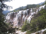
The Shuzheng Valley (树正沟, Shùzhèng Gōu) is the northern (main) branch of Jiuzhaigou. It ends after 14.5 km (9 mi) at the Y-shaped intersection of the three gullies. Going downhill from the intersection to the mouth of the valley, visitors encounter the following:- Nuorilang Falls (诺日朗瀑布, Nuòrìlǎng Pùbù), near the junction of the valleys, are 20 m high and 320 m wide. They are reportedly the widest highland waterfall in China, the widest travertine-topped waterfall in the world, and one of the symbols of Jiuzhaigou.
- Nuorilang Lakes (诺日朗群海, Nuòrìlǎng Qúnhǎi) and Shuzheng Lakes (树正群海 Shùzhèng Qúnhǎi) are stepped series of respectively 18 and 19 ribbon lakeRibbon lakeA ribbon lake or loch is a long and narrow, finger-shaped lake, usually found in a glacial trough. Its formation begins when a glacier moves over an area containing alternate bands of hard and soft bedrock...
s formed by the passage of glacierGlacierA glacier is a large persistent body of ice that forms where the accumulation of snow exceeds its ablation over many years, often centuries. At least 0.1 km² in area and 50 m thick, but often much larger, a glacier slowly deforms and flows due to stresses induced by its weight...
s, then naturally dammed. Some of them have their own folkloric names, such as the Rhinoceros, Unknown, and Tiger lakes. - Sleeping Dragon Lake (卧龙海, Wòlóng Hǎi) is one of the lower lakes in the area. With a depth of 20 m, it is notable for the clearly visible calcareous dyke running through it, whose shape has been compared to a dragonChinese dragonChinese dragons are legendary creatures in Chinese mythology and folklore, with mythic counterparts among Japanese, Korean, Vietnamese, Bhutanese, Western and Turkic dragons. In Chinese art, dragons are typically portrayed as long, scaled, serpentine creatures with four legs...
lying on the bottom. - Reed Lake (芦苇海, Lúwěi Hǎi) is a 1375 m-long, reed-covered marsh with a clear turquoise brook (known as the "Jade Ribbon") zigzaging through it. The contrast is particularly striking in the autumn when the reeds turn golden yellow.
Others
- The Fairy Pool (神仙池, Shénxiān Chí) lies 42 km (26 mi) west of Jiuzhaigou and features travertineTravertineTravertine is a form of limestone deposited by mineral springs, especially hot springs. Travertine often has a fibrous or concentric appearance and exists in white, tan, and cream-colored varieties. It is formed by a process of rapid precipitation of calcium carbonate, often at the mouth of a hot...
pools very similar to those of the nearby HuanglongHuanglongHuanglong is a scenic and historic interest area in the northwest part of Sichuan, People's Republic of China. It is located in the southern part of the Minshan mountain range, north-northwest of the capital Chengdu...
Natural Reserve.
Ecotourism
The Zharu Valley (扎如沟, Zārú Gōu) runs southeast from the main Shuzheng gully and is rarely visited by tourists. The valley begins at the Zharu Buddhist monasteryMonastery
Monastery denotes the building, or complex of buildings, that houses a room reserved for prayer as well as the domestic quarters and workplace of monastics, whether monks or nuns, and whether living in community or alone .Monasteries may vary greatly in size – a small dwelling accommodating only...
and ends at the Red, Black, and Daling lakes.
Zharu Valley is the home of eco-tourism in Jiuzhaigou. The valley has recently been opened to a small number of ecotourists wishing to go hiking and camping off the beaten track. Visitors can choose from day walks and multiple day hikes, depending on their time availability. Knowledgeable guides accompany ecotourists through the valley, sharing their knowledge about the unique biodiversity and local culture of the national park. The Zharu Valley has 40% of all the plant species that exist in China and it is the best place to spot wildlife inside the national park.
The main hike follows the pilgrimage of the local Benbo Buddhists circumnavigating the sacred 4,528 m Zha Yi Zha Ga Mountain.
Access
Jiuzhaigou, compared to other high-traffic scenic spots in China can be difficult to access by land. The majority of tourists reach the valley by a 10-hour bus ride from Chengdu along the Minjiang River canyonCanyon
A canyon or gorge is a deep ravine between cliffs often carved from the landscape by a river. Rivers have a natural tendency to reach a baseline elevation, which is the same elevation as the body of water it will eventually drain into. This forms a canyon. Most canyons were formed by a process of...
, prone to occasional minor rockslides and in the rainy season, mudslides that can add several hours to the trip. The new highway that had been constructed along this route was badly damaged during the May 12th 2008 earthquake but has now been repaired. Further repairs from Mao Xian to Chuan Zhu Si are still ongoing but the road is open to public buses and private vehicles.
Since 2003, it has been possible to fly from Chengdu
Chengdu
Chengdu , formerly transliterated Chengtu, is the capital of Sichuan province in Southwest China. It holds sub-provincial administrative status...
or Chongqing
Chongqing
Chongqing is a major city in Southwest China and one of the five national central cities of China. Administratively, it is one of the PRC's four direct-controlled municipalities , and the only such municipality in inland China.The municipality was created on 14 March 1997, succeeding the...
to Jiuzhaigou Huanglong Airport
Jiuzhaigou Huanglong Airport
Jiuzhai Huanglong Airport , also known as Jiuzhaigou Airport and Jiuhuang Airport, is an airport in Songpan, Sichuan Province, China. This airport serves two major scenic places of interest in this area, namely Huanglong and Jiuzhaigou...
on a 11311 ft (3,448 m) high mountain side near Songpan County, and then take an hour-long bus ride to Huanglong, or a 90-minute bus ride to Jiuzhaigou. From 2006, a daily flight to Xi'an
Xi'an
Xi'an is the capital of the Shaanxi province, and a sub-provincial city in the People's Republic of China. One of the oldest cities in China, with more than 3,100 years of history, the city was known as Chang'an before the Ming Dynasty...
had been opened in peak season and new flights are being added all the time from different parts of China. In October 2009 new direct flights were added from Beijing, Shanghai and Hangzhou
Hangzhou
Hangzhou , formerly transliterated as Hangchow, is the capital and largest city of Zhejiang Province in Eastern China. Governed as a sub-provincial city, and as of 2010, its entire administrative division or prefecture had a registered population of 8.7 million people...
. Jiuzhaigou or Huanglong National Parks did not experience any damage during the earthquake of May 2008 and never closed after the event.
See also
Related places- Pearl Waterfall
- Huanglong scenic area, south of Jiuzhaigou
Related lists
- List of World Heritage Sites in China
- List of Biosphere Reserves in China
External links
NGO links- Jiuzhaigou at the World Heritage Sites of UNESCOUNESCOThe United Nations Educational, Scientific and Cultural Organization is a specialized agency of the United Nations...
- Jiuzhaigou at the MAB Biosphere Reserves of UNESCO
- Jiuzhaigou at the Terrestrial Ecosystem Monitoring Sites (TEMS) of FAOFãoFão is a town in Esposende Municipality in Portugal....
Other links