

January 2007 North American ice storm
Encyclopedia
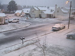
The North American ice storm of 2007 was a severe ice storm
that impacted a large swath of North America
from the Rio Grande Valley
to New England
and southeastern Canada
starting on January 11, 2007 through January 16, followed by a second wave in the Southern United States
from Texas
to the Carolinas from January 16 through January 18 and a third one that hit the southern Plains and mid-Atlantic states as well as Newfoundland and Labrador
from January 19 to January 24. It resulted in at least 85 deaths across 12 U.S. states and three Canadian provinces, and caused hundreds of thousands of residents across the U.S and Canada to lose electric power
.
The event was similar to the 1998 Ice storm
that struck portions of eastern Canada
and northern New England
which was affected by multiple waves of ice precipitation over a period of five days.
experienced very mild conditions through the first week and a half of January, with several record-breaking warm temperatures across most of the Midwest and Eastern U.S. and Canada. Several regions had recorded warmer than normal temperatures for over 30 days in a row. On January 8, a cold front
, which was responsible for a major blizzard
across Alberta
, Saskatchewan
and Manitoba
, sagged across most of the continent, bringing with it much colder temperatures. A deep trough
in the jet stream favored a more active weather pattern and waves of low pressure started to develop over the Gulf of Mexico
starting on January 17.
 The main storm developed in the Southwest of the U.S and quickly expanded over the Deep South near the Gulf of Mexico. Frozen precipitation spread across a wide region, from northern Texas
north and east to the New England States as arctic air sank southward with overriding warm air from the Gulf of Mexico
. Ice storm warnings were in effect for northwestern Arkansas
, central Illinois
, extreme southeastern Kansas
, a large part of Missouri
, central and eastern Oklahoma
, northern and central Texas
as well as portions of Michigan
, Indiana
and Ontario
. Several waves of precipitation crossed those states from the 12th to the 16th, including the main event on the 14th.
The main storm moved northeastward, affecting the Great Lakes
region, New England and the Canadian Maritimes from the 14th to the 16th. With the exception of southern Ontario and Nova Scotia
, most of the precipitation in Canada fell in the form of snow. The storm departed Newfoundland and Labrador
later on the 16th.
Meanwhile, another wave developed near the U.S.-Mexico border and tracked east across southeastern Texas towards the Carolinas from the 16th to the 18th. It brought a wintry mix, including a heavy snowstorm, to eastern Canada
and Maine
on the 19th.In the Gulf of Mexico,high wind speeds.
A second winter storm developed in Texas
and brought another round of heavy wintry precipitation from Arizona
into the Great Lakes
region. The large storm also affected the Midwest and some of the mid-Atlantic states before moving into the Atlantic Ocean
and hitting Newfoundland and Labrador
on the 24th before heading towards the Arctic
region.
Brad Henry
declared a state of emergency
for the entire state due to the ice storm. U.S. President George W. Bush
later declared Oklahoma a federal disaster area.
In Oklahoma, in addition to major tree damage, about 40,000 customers lost power after the first wave of freezing rain on January 12. After additional waves of ice and sleet, 120,000 customers were without power (60 000 of them for over a week). One of the hardest hit areas was the city of McAlester
in the eastern part of the state in Pittsburg County
where most of the town was without power for several days. Thousands of residents sought refuges set up by the American Red Cross
with 1,000 still remaining as of January 20th.
For the first time in the history of the Big 12 Conference
, a conference basketball
game was postponed when the Oklahoma State men's team
was not able to fly out of either Stillwater
or Oklahoma City
to make its January 13 game at Nebraska
. The game was rescheduled to March 5. For the second time this season, an NBA
game was postponed due to severe winter weather. The New Orleans/Oklahoma City Hornets
, scheduled to play the Milwaukee Bucks
in Milwaukee
on January 13, were unable to catch a flight out of Oklahoma City
. The following day, a second Big 12 basketball game, this time a women's game between Oklahoma
and Texas Tech
, was postponed when the Lady Raiders were not able to get to Norman
. This game was rescheduled to January 22.
On the 21st, during the third wave of wintry precipitation, a truck carrying hazardous materials went missing after falling from a bridge into a creek in Pittsburg County. No injuries were reported but the contents of the truck disappeared.
In Oklahoma City on January 14, there was a 3 hour period of thundersleet between 8:45 am and 11:36 am with temperatures in the low to mid 20s.
Damage in the state totaled about $38 million (2007 USD).
, declared a state of emergency and called in the National Guard
. In southwestern Missouri, a local disaster area was declared.
At the peak of the storm, a total of 330,000 customers of Ameren were without power. In Springfield, Missouri
alone, about 70,000 were in the dark (with rural areas almost completely without power) with the worst still to come, while in east Missouri and central Illinois, over 110,000 customers were without power, particularly around St. Louis
. Some restoration took place that afternoon before the next round of freezing rain developed. Extensive damage to trees and power lines has been reported in Missouri. Amtrak
service was also shut down across Missouri due to downed trees. The White House
declared 34 counties including St. Louis disaster areas. Damage in Missouri totaled $352.9 million (2007 USD).
Nearly 3,600 residents across the state sought refuge at 85 different shelters.
, Waco
and Houston
were affected from the 14th to the 16th.
In Texas, Governor Rick Perry
's inauguration parade and Martin Luther King, Jr. Day festivities were cancelled while over 400 flights from Dallas-Fort Worth International Airport
were cancelled on the 14th with several hundred additional trips cancelled during the following days. Several flights were also cancelled at Austin-Bergstrom International Airport
as well as at San Antonio International Airport
. A large section of Interstate 10
near the San Antonio
area had to be shut down on the 16th because of snow and ice covering the highway. Several schools, universities and offices were shut down as well.
Power outages in the state were limited. 4,400 customers were without power in North Texas on the 15th. Another 4,500 homes were blacked out in central Texas near the San Antonio area. Over 35,000 were left without power in the state's capital of Austin
between the 12th and the 18th.
90 National Guard
members were mobilized prior to the second major storm on the 19th and 20th.
 Freezing rain hit the Carolinas on the 17th and 18th, leading to school closures in both states, including in the Charlotte
and Raleigh-Durham regions, as well as the Columbia, South Carolina
, area. Several flights from Raleigh-Durham
and Charlotte international airports were canceled, and police in North Carolina reported over 600 traffic accidents, including two fatal ones and two accidents involving school buses.
, but also some of the other states in the southern Midwest.
The storm also hit Colorado, which was previously hit with several blizzard events in December. It shut down parts of Interstate 70
between Denver and Kansas City
. Power was lost due to blowing snow and whiteout conditions.
plane linking Milwaukee to Detroit via Flight 1726 slipped off a snow-filled runway after a mechanical failure during the storm. No injuries were reported in the incident, which took place shortly after takeoff from General Mitchell International Airport
in Milwaukee.
customers in Ontario, especially near the Lake Erie
shoreline, were without power, along with many more homes across the province. GO Train service in Toronto as well as flights from Pearson International Airport were heavily affected on the 15th. Ontario Provincial Police
reported nearly 500 traffic accidents in the region, including one involving a tractor trailer carrying liquid oxygen
that slid on its side after a collision in the interchange of Highways 400 and 407. Another accident near Drummondville involving a bus injured 24 American students, who were in Quebec
on a ski tour.
Heavy snows and mixed precipitation in Atlantic Canada
and eastern Quebec caused by a weather bomb disrupted travel on the 19th. The Confederation Bridge
linking New Brunswick
to Prince Edward Island
had to be shut down to truck traffic for several hours due to strong winds and mixed precipitation. Many schools in New Brunswick including the Fredericton and Moncton areas were closed. Local power outages were reported. Several roads in the Quebec regions of Gaspésie and Côte-Nord
including Routes 132
, 138
, and 195
have been completely shut down due to heavy amount of snow and blowing snow. Schools were also closed in Newfoundland and Labrador due to blizzard conditions on the 24th.
, eight in Iowa
, twelve in Texas
, two in Minnesota
, four in New York
, one in Maine
, one in Indiana
, four in Michigan
, three in Arkansas
, one in Quebec
, one in Ontario
, one in Nova Scotia
, two in North Carolina
, three in Kansas
, four in Nebraska
and twenty-six in Oklahoma
. An accident near Elk City, Oklahoma
, killed seven occupants who were inside a minivan
when it hit a tractor-trailer during the storm.
to Illinois
after 3 rounds of freezing rain with locally heavier amounts especially in Missouri
and Oklahoma
where there were reports of amounts exceeding 4 inches (100 mm).
Heavy amounts of ice were also reported across portions of Lower Michigan, in southern Ontario from Windsor
to Toronto
and in New York
and New Hampshire
. In New York City
, about 3.5 inches of ice
fell.
Heavy snows also fell across the northwestern quadrant of the storm. Heavy snows fell in parts of Nebraska
and Colorado
on the 13th and 14th, with more eastern areas such as Iowa
, Wisconsin
, Michigan
, Maine
, Ontario
, Quebec
and New Brunswick
being on the 15th and 16th. Montreal
and Sherbrooke received just over 8 inches (20 cm) of snow. Portions of Maine
received as much as 10 inches of snow (25 cm).
Near blizzard conditions were reported in Atlantic Canada
and eastern Quebec on the 19th. In the Gaspésie region of Quebec, as much as 32 inches (80 cm) of snow fell. There were others reports of snowfall of between 8 and 18 inches (20–45 cm) across Atlantic Canada. Damaging winds in excess of 60 mph (100 km/h) were also reported along with blowing snow. Maine also received up to 10 additional inches (25 cm) of snow from this wave of precipitation.
Between 4 and 10 inches (10–25 cm) of snow fell across the central and southern Plains from the 19th to the 21st as the result of another large winter storm. Places such as Phoenix
and Tucson
in Arizona
also received a rare light snowfall on the 21st while a foot of snow was reported in the mountains in the northern part of the state.
About 10 inches of snow was reported in parts of Newfoundland and Labrador on the 24th, while mixed wintry precipitation was reported in the capital St. John's
along with winds in excess of 65 mph (105 km/h)
 The first large winter storm was followed by a period of intense cold across most of the continent with some of the coldest temperatures recorded so far in 2006-07 winter season through most of the continent. Deep cold was reported from California
to Nova Scotia
. Mount Washington
, New Hampshire's highest peak at 6,288' (1917m), recorded a windchill of -85 °F (-65 °C) early on 17 January.
Due to the cold spell's effect, a large portion of California
's orange
crops were damaged.
Ice storm
An ice storm is a type of winter storm characterized by freezing rain, also known as a glaze event or in some parts of the United States as a silver thaw. The U.S. National Weather Service defines an ice storm as a storm which results in the accumulation of at least of ice on exposed surfaces...
that impacted a large swath of North America
North America
North America is a continent wholly within the Northern Hemisphere and almost wholly within the Western Hemisphere. It is also considered a northern subcontinent of the Americas...
from the Rio Grande Valley
Rio Grande Valley
The Rio Grande Valley or the Lower Rio Grande Valley, informally called The Valley, is an area located in the southernmost tip of South Texas...
to New England
New England
New England is a region in the northeastern corner of the United States consisting of the six states of Maine, New Hampshire, Vermont, Massachusetts, Rhode Island, and Connecticut...
and southeastern Canada
Canada
Canada is a North American country consisting of ten provinces and three territories. Located in the northern part of the continent, it extends from the Atlantic Ocean in the east to the Pacific Ocean in the west, and northward into the Arctic Ocean...
starting on January 11, 2007 through January 16, followed by a second wave in the Southern United States
Southern United States
The Southern United States—commonly referred to as the American South, Dixie, or simply the South—constitutes a large distinctive area in the southeastern and south-central United States...
from Texas
Texas
Texas is the second largest U.S. state by both area and population, and the largest state by area in the contiguous United States.The name, based on the Caddo word "Tejas" meaning "friends" or "allies", was applied by the Spanish to the Caddo themselves and to the region of their settlement in...
to the Carolinas from January 16 through January 18 and a third one that hit the southern Plains and mid-Atlantic states as well as Newfoundland and Labrador
Newfoundland and Labrador
Newfoundland and Labrador is the easternmost province of Canada. Situated in the country's Atlantic region, it incorporates the island of Newfoundland and mainland Labrador with a combined area of . As of April 2011, the province's estimated population is 508,400...
from January 19 to January 24. It resulted in at least 85 deaths across 12 U.S. states and three Canadian provinces, and caused hundreds of thousands of residents across the U.S and Canada to lose electric power
Power outage
A power outage is a short- or long-term loss of the electric power to an area.There are many causes of power failures in an electricity network...
.
The event was similar to the 1998 Ice storm
North American ice storm of 1998
The North American ice storm of 1998 was a massive combination of five smaller successive ice storms which combined to strike a relatively narrow swath of land from eastern Ontario to southern Quebec to Nova Scotia in Canada, and bordering areas from northern New York to central Maine in the...
that struck portions of eastern Canada
Canada
Canada is a North American country consisting of ten provinces and three territories. Located in the northern part of the continent, it extends from the Atlantic Ocean in the east to the Pacific Ocean in the west, and northward into the Arctic Ocean...
and northern New England
New England
New England is a region in the northeastern corner of the United States consisting of the six states of Maine, New Hampshire, Vermont, Massachusetts, Rhode Island, and Connecticut...
which was affected by multiple waves of ice precipitation over a period of five days.
Prior to the storm
Before the storm, most of North AmericaNorth America
North America is a continent wholly within the Northern Hemisphere and almost wholly within the Western Hemisphere. It is also considered a northern subcontinent of the Americas...
experienced very mild conditions through the first week and a half of January, with several record-breaking warm temperatures across most of the Midwest and Eastern U.S. and Canada. Several regions had recorded warmer than normal temperatures for over 30 days in a row. On January 8, a cold front
Cold front
A cold front is defined as the leading edge of a cooler mass of air, replacing a warmer mass of air.-Development of cold front:The cooler and denser air wedges under the less-dense warmer air, lifting it...
, which was responsible for a major blizzard
Blizzard
A blizzard is a severe snowstorm characterized by strong winds. By definition, the difference between blizzard and a snowstorm is the strength of the wind. To be a blizzard, a snow storm must have winds in excess of with blowing or drifting snow which reduces visibility to 400 meters or ¼ mile or...
across Alberta
Alberta
Alberta is a province of Canada. It had an estimated population of 3.7 million in 2010 making it the most populous of Canada's three prairie provinces...
, Saskatchewan
Saskatchewan
Saskatchewan is a prairie province in Canada, which has an area of . Saskatchewan is bordered on the west by Alberta, on the north by the Northwest Territories, on the east by Manitoba, and on the south by the U.S. states of Montana and North Dakota....
and Manitoba
Manitoba
Manitoba is a Canadian prairie province with an area of . The province has over 110,000 lakes and has a largely continental climate because of its flat topography. Agriculture, mostly concentrated in the fertile southern and western parts of the province, is vital to the province's economy; other...
, sagged across most of the continent, bringing with it much colder temperatures. A deep trough
Trough (meteorology)
A trough is an elongated region of relatively low atmospheric pressure, often associated with fronts.Unlike fronts, there is not a universal symbol for a trough on a weather chart. The weather charts in some countries or regions mark troughs by a line. In the United States, a trough may be marked...
in the jet stream favored a more active weather pattern and waves of low pressure started to develop over the Gulf of Mexico
Gulf of Mexico
The Gulf of Mexico is a partially landlocked ocean basin largely surrounded by the North American continent and the island of Cuba. It is bounded on the northeast, north and northwest by the Gulf Coast of the United States, on the southwest and south by Mexico, and on the southeast by Cuba. In...
starting on January 17.
Storm track
Texas
Texas is the second largest U.S. state by both area and population, and the largest state by area in the contiguous United States.The name, based on the Caddo word "Tejas" meaning "friends" or "allies", was applied by the Spanish to the Caddo themselves and to the region of their settlement in...
north and east to the New England States as arctic air sank southward with overriding warm air from the Gulf of Mexico
Gulf of Mexico
The Gulf of Mexico is a partially landlocked ocean basin largely surrounded by the North American continent and the island of Cuba. It is bounded on the northeast, north and northwest by the Gulf Coast of the United States, on the southwest and south by Mexico, and on the southeast by Cuba. In...
. Ice storm warnings were in effect for northwestern Arkansas
Arkansas
Arkansas is a state located in the southern region of the United States. Its name is an Algonquian name of the Quapaw Indians. Arkansas shares borders with six states , and its eastern border is largely defined by the Mississippi River...
, central Illinois
Illinois
Illinois is the fifth-most populous state of the United States of America, and is often noted for being a microcosm of the entire country. With Chicago in the northeast, small industrial cities and great agricultural productivity in central and northern Illinois, and natural resources like coal,...
, extreme southeastern Kansas
Kansas
Kansas is a US state located in the Midwestern United States. It is named after the Kansas River which flows through it, which in turn was named after the Kansa Native American tribe, which inhabited the area. The tribe's name is often said to mean "people of the wind" or "people of the south...
, a large part of Missouri
Missouri
Missouri is a US state located in the Midwestern United States, bordered by Iowa, Illinois, Kentucky, Tennessee, Arkansas, Oklahoma, Kansas and Nebraska. With a 2010 population of 5,988,927, Missouri is the 18th most populous state in the nation and the fifth most populous in the Midwest. It...
, central and eastern Oklahoma
Oklahoma
Oklahoma is a state located in the South Central region of the United States of America. With an estimated 3,751,351 residents as of the 2010 census and a land area of 68,667 square miles , Oklahoma is the 28th most populous and 20th-largest state...
, northern and central Texas
Texas
Texas is the second largest U.S. state by both area and population, and the largest state by area in the contiguous United States.The name, based on the Caddo word "Tejas" meaning "friends" or "allies", was applied by the Spanish to the Caddo themselves and to the region of their settlement in...
as well as portions of Michigan
Michigan
Michigan is a U.S. state located in the Great Lakes Region of the United States of America. The name Michigan is the French form of the Ojibwa word mishigamaa, meaning "large water" or "large lake"....
, Indiana
Indiana
Indiana is a US state, admitted to the United States as the 19th on December 11, 1816. It is located in the Midwestern United States and Great Lakes Region. With 6,483,802 residents, the state is ranked 15th in population and 16th in population density. Indiana is ranked 38th in land area and is...
and Ontario
Ontario
Ontario is a province of Canada, located in east-central Canada. It is Canada's most populous province and second largest in total area. It is home to the nation's most populous city, Toronto, and the nation's capital, Ottawa....
. Several waves of precipitation crossed those states from the 12th to the 16th, including the main event on the 14th.
The main storm moved northeastward, affecting the Great Lakes
Great Lakes
The Great Lakes are a collection of freshwater lakes located in northeastern North America, on the Canada – United States border. Consisting of Lakes Superior, Michigan, Huron, Erie, and Ontario, they form the largest group of freshwater lakes on Earth by total surface, coming in second by volume...
region, New England and the Canadian Maritimes from the 14th to the 16th. With the exception of southern Ontario and Nova Scotia
Nova Scotia
Nova Scotia is one of Canada's three Maritime provinces and is the most populous province in Atlantic Canada. The name of the province is Latin for "New Scotland," but "Nova Scotia" is the recognized, English-language name of the province. The provincial capital is Halifax. Nova Scotia is the...
, most of the precipitation in Canada fell in the form of snow. The storm departed Newfoundland and Labrador
Newfoundland and Labrador
Newfoundland and Labrador is the easternmost province of Canada. Situated in the country's Atlantic region, it incorporates the island of Newfoundland and mainland Labrador with a combined area of . As of April 2011, the province's estimated population is 508,400...
later on the 16th.
Meanwhile, another wave developed near the U.S.-Mexico border and tracked east across southeastern Texas towards the Carolinas from the 16th to the 18th. It brought a wintry mix, including a heavy snowstorm, to eastern Canada
Canada
Canada is a North American country consisting of ten provinces and three territories. Located in the northern part of the continent, it extends from the Atlantic Ocean in the east to the Pacific Ocean in the west, and northward into the Arctic Ocean...
and Maine
Maine
Maine is a state in the New England region of the northeastern United States, bordered by the Atlantic Ocean to the east and south, New Hampshire to the west, and the Canadian provinces of Quebec to the northwest and New Brunswick to the northeast. Maine is both the northernmost and easternmost...
on the 19th.In the Gulf of Mexico,high wind speeds.
A second winter storm developed in Texas
Texas
Texas is the second largest U.S. state by both area and population, and the largest state by area in the contiguous United States.The name, based on the Caddo word "Tejas" meaning "friends" or "allies", was applied by the Spanish to the Caddo themselves and to the region of their settlement in...
and brought another round of heavy wintry precipitation from Arizona
Arizona
Arizona ; is a state located in the southwestern region of the United States. It is also part of the western United States and the mountain west. The capital and largest city is Phoenix...
into the Great Lakes
Great Lakes
The Great Lakes are a collection of freshwater lakes located in northeastern North America, on the Canada – United States border. Consisting of Lakes Superior, Michigan, Huron, Erie, and Ontario, they form the largest group of freshwater lakes on Earth by total surface, coming in second by volume...
region. The large storm also affected the Midwest and some of the mid-Atlantic states before moving into the Atlantic Ocean
Atlantic Ocean
The Atlantic Ocean is the second-largest of the world's oceanic divisions. With a total area of about , it covers approximately 20% of the Earth's surface and about 26% of its water surface area...
and hitting Newfoundland and Labrador
Newfoundland and Labrador
Newfoundland and Labrador is the easternmost province of Canada. Situated in the country's Atlantic region, it incorporates the island of Newfoundland and mainland Labrador with a combined area of . As of April 2011, the province's estimated population is 508,400...
on the 24th before heading towards the Arctic
Arctic
The Arctic is a region located at the northern-most part of the Earth. The Arctic consists of the Arctic Ocean and parts of Canada, Russia, Greenland, the United States, Norway, Sweden, Finland, and Iceland. The Arctic region consists of a vast, ice-covered ocean, surrounded by treeless permafrost...
region.
Oklahoma
Governor of OklahomaGovernor of Oklahoma
The governor of the state of Oklahoma is the head of state for the state of Oklahoma, United States. Under the Oklahoma Constitution, the governor is also the head of government, serving as the chief executive of the Oklahoma executive branch, of the government of Oklahoma...
Brad Henry
Brad Henry
Charles Bradford "Brad" Henry was the 26th Governor of the U.S. state of Oklahoma. A member of the Democratic Party, he was elected governor in 2002...
declared a state of emergency
State of emergency
A state of emergency is a governmental declaration that may suspend some normal functions of the executive, legislative and judicial powers, alert citizens to change their normal behaviours, or order government agencies to implement emergency preparedness plans. It can also be used as a rationale...
for the entire state due to the ice storm. U.S. President George W. Bush
George W. Bush
George Walker Bush is an American politician who served as the 43rd President of the United States, from 2001 to 2009. Before that, he was the 46th Governor of Texas, having served from 1995 to 2000....
later declared Oklahoma a federal disaster area.
In Oklahoma, in addition to major tree damage, about 40,000 customers lost power after the first wave of freezing rain on January 12. After additional waves of ice and sleet, 120,000 customers were without power (60 000 of them for over a week). One of the hardest hit areas was the city of McAlester
McAlester, Oklahoma
McAlester is a city in Pittsburg County, Oklahoma, United States. The population was 17,783 at the 2000 census. It is the county seat of Pittsburg County. It is currently the largest city in the Choctaw Nation of Oklahoma, followed by Durant....
in the eastern part of the state in Pittsburg County
Pittsburg County, Oklahoma
Pittsburg County is a county located in the U.S. state of Oklahoma. As of 2000, the population was 43,953. Its county seat is McAlester.-Geography:According to the U.S. Census Bureau, the county has a total area of 3,569 km²...
where most of the town was without power for several days. Thousands of residents sought refuges set up by the American Red Cross
American Red Cross
The American Red Cross , also known as the American National Red Cross, is a volunteer-led, humanitarian organization that provides emergency assistance, disaster relief and education inside the United States. It is the designated U.S...
with 1,000 still remaining as of January 20th.
For the first time in the history of the Big 12 Conference
Big 12 Conference
The Big 12 Conference is a college athletic conference of ten schools located in the Central United States, with its headquarters located in Las Colinas, a community in the Dallas, Texas suburb of Irving...
, a conference basketball
College basketball
College basketball most often refers to the USA basketball competitive governance structure established by the National Collegiate Athletic Association . Basketball in the NCAA is divided into three divisions: Division I, Division II and Division III....
game was postponed when the Oklahoma State men's team
Oklahoma State Cowboys
Oklahoma State Cowboys are the athletic teams that represent Oklahoma State University. Their mascot is a cowboy named Pistol Pete. Oklahoma State participates in the NCAA's Division I-A and in the Big 12 Conference's South Division. The university's current athletic director is Mike Holder...
was not able to fly out of either Stillwater
Stillwater Regional Airport
Stillwater Regional Airport is a city-owned public-use airport located three nautical miles northwest of the central business district of Stillwater, a city in Payne County, Oklahoma, United States...
or Oklahoma City
Will Rogers World Airport
Will Rogers World Airport , also known as Will Rogers Airport or simply Will Rogers, is located in southwestern Oklahoma City, Oklahoma 6 miles from downtown and is the principal commercial airport of the Oklahoma City Metropolitan Area...
to make its January 13 game at Nebraska
Nebraska Cornhuskers
The Nebraska Cornhuskers is the name given to several sports teams of the University of Nebraska–Lincoln. The university is a member of the Big Ten Conference...
. The game was rescheduled to March 5. For the second time this season, an NBA
National Basketball Association
The National Basketball Association is the pre-eminent men's professional basketball league in North America. It consists of thirty franchised member clubs, of which twenty-nine are located in the United States and one in Canada...
game was postponed due to severe winter weather. The New Orleans/Oklahoma City Hornets
New Orleans/Oklahoma City Hornets
The New Orleans Hornets are a professional basketball team based in New Orleans, Louisiana. They play in the Southwest Division of the Western Conference of the National Basketball Association. The franchise began play during the 1988–89 NBA season as the Charlotte Hornets, based in Charlotte,...
, scheduled to play the Milwaukee Bucks
Milwaukee Bucks
The Milwaukee Bucks are a professional basketball team based in Milwaukee, Wisconsin, United States. They are part of the Central Division of the Eastern Conference in the National Basketball Association . The team was founded in 1968 as an expansion team, and currently plays at the Bradley Center....
in Milwaukee
Milwaukee, Wisconsin
Milwaukee is the largest city in the U.S. state of Wisconsin, the 28th most populous city in the United States and 39th most populous region in the United States. It is the county seat of Milwaukee County and is located on the southwestern shore of Lake Michigan. According to 2010 census data, the...
on January 13, were unable to catch a flight out of Oklahoma City
Oklahoma City, Oklahoma
Oklahoma City is the capital and the largest city in the state of Oklahoma. The county seat of Oklahoma County, the city ranks 31st among United States cities in population. The city's population, from the 2010 census, was 579,999, with a metro-area population of 1,252,987 . In 2010, the Oklahoma...
. The following day, a second Big 12 basketball game, this time a women's game between Oklahoma
Oklahoma Sooners
The University of Oklahoma features 19 varsity sports teams. Both men's and women's teams are called the Sooners, a nickname given to the early participants in the land rushes which initially opened the Oklahoma Indian Territory to non-native settlement. They participate in the NCAA's Division I-A,...
and Texas Tech
Texas Tech Red Raiders
The Texas Tech Red Raiders are the athletic teams that represent Texas Tech University . The women's basketball team uses the name Lady Raiders; however, the school's other women's teams use the "Red Raiders" name. The university's athletic program fields teams in 15 varsity sports and 30 club sports...
, was postponed when the Lady Raiders were not able to get to Norman
Norman, Oklahoma
Norman is a city in Cleveland County, Oklahoma, United States, and is located south of downtown Oklahoma City. It is part of the Oklahoma City metropolitan area. As of the 2010 census, Norman was to have 110,925 full-time residents, making it the third-largest city in Oklahoma and the...
. This game was rescheduled to January 22.
On the 21st, during the third wave of wintry precipitation, a truck carrying hazardous materials went missing after falling from a bridge into a creek in Pittsburg County. No injuries were reported but the contents of the truck disappeared.
In Oklahoma City on January 14, there was a 3 hour period of thundersleet between 8:45 am and 11:36 am with temperatures in the low to mid 20s.
Damage in the state totaled about $38 million (2007 USD).
Missouri and Illinois
The Governor of Missouri, Matt BluntMatt Blunt
Matthew Roy Blunt served as the 54th Governor of Missouri from 2005 to 2009. Before his election as governor, Blunt served ten years in the United States Navy, was elected to serve in the Missouri General Assembly in 1998 and as Missouri's Secretary of State in 2000.A Republican, Blunt was elected...
, declared a state of emergency and called in the National Guard
United States National Guard
The National Guard of the United States is a reserve military force composed of state National Guard militia members or units under federally recognized active or inactive armed force service for the United States. Militia members are citizen soldiers, meaning they work part time for the National...
. In southwestern Missouri, a local disaster area was declared.
At the peak of the storm, a total of 330,000 customers of Ameren were without power. In Springfield, Missouri
Springfield, Missouri
Springfield is the third largest city in the U.S. state of Missouri and the county seat of Greene County. According to the 2010 census data, the population was 159,498, an increase of 5.2% since the 2000 census. The Springfield Metropolitan Area, population 436,712, includes the counties of...
alone, about 70,000 were in the dark (with rural areas almost completely without power) with the worst still to come, while in east Missouri and central Illinois, over 110,000 customers were without power, particularly around St. Louis
St. Louis, Missouri
St. Louis is an independent city on the eastern border of Missouri, United States. With a population of 319,294, it was the 58th-largest U.S. city at the 2010 U.S. Census. The Greater St...
. Some restoration took place that afternoon before the next round of freezing rain developed. Extensive damage to trees and power lines has been reported in Missouri. Amtrak
Amtrak
The National Railroad Passenger Corporation, doing business as Amtrak , is a government-owned corporation that was organized on May 1, 1971, to provide intercity passenger train service in the United States. "Amtrak" is a portmanteau of the words "America" and "track". It is headquartered at Union...
service was also shut down across Missouri due to downed trees. The White House
White House
The White House is the official residence and principal workplace of the president of the United States. Located at 1600 Pennsylvania Avenue NW in Washington, D.C., the house was designed by Irish-born James Hoban, and built between 1792 and 1800 of white-painted Aquia sandstone in the Neoclassical...
declared 34 counties including St. Louis disaster areas. Damage in Missouri totaled $352.9 million (2007 USD).
Nearly 3,600 residents across the state sought refuge at 85 different shelters.
Texas
Most of the state endured several waves of precipitation. Precipitation fell from the Panhandle region near Amarillo to the Dallas and Fort Worth area on the 13th. Areas further south such as AustinAustin, Texas
Austin is the capital city of the U.S. state of :Texas and the seat of Travis County. Located in Central Texas on the eastern edge of the American Southwest, it is the fourth-largest city in Texas and the 14th most populous city in the United States. It was the third-fastest-growing large city in...
, Waco
Waco, Texas
Waco is a city in and the county seat of McLennan County, Texas. Situated along the Brazos River and on the I-35 corridor, halfway between Dallas and Austin, it is the economic, cultural, and academic center of the 'Heart of Texas' region....
and Houston
Houston, Texas
Houston is the fourth-largest city in the United States, and the largest city in the state of Texas. According to the 2010 U.S. Census, the city had a population of 2.1 million people within an area of . Houston is the seat of Harris County and the economic center of , which is the ...
were affected from the 14th to the 16th.
In Texas, Governor Rick Perry
Rick Perry
James Richard "Rick" Perry is the 47th and current Governor of Texas. A Republican, Perry was elected Lieutenant Governor of Texas in 1998 and assumed the governorship in December 2000 when then-governor George W. Bush resigned to become President of the United States. Perry was elected to full...
's inauguration parade and Martin Luther King, Jr. Day festivities were cancelled while over 400 flights from Dallas-Fort Worth International Airport
Dallas-Fort Worth International Airport
Dallas/Fort Worth International Airport is located between the cities of Dallas and Fort Worth, Texas, and is the busiest airport in the U.S. state of Texas...
were cancelled on the 14th with several hundred additional trips cancelled during the following days. Several flights were also cancelled at Austin-Bergstrom International Airport
Austin-Bergstrom International Airport
Austin-Bergstrom International Airport is a mixed-use commercial airport located southeast of the central business district of Austin, Texas, United States. It covers and has two runways and three helipads.The airport began passenger service on May 23, 1999...
as well as at San Antonio International Airport
San Antonio International Airport
San Antonio International Airport is a commercial airport in San Antonio, Texas, USA. The airport has three runways and covers . Its elevation is above sea level. SAT is a Class C airport.- Overview :...
. A large section of Interstate 10
Interstate 10
Interstate 10 is the fourth-longest Interstate Highway in the United States, after I-90, I-80, and I-40. It is the southernmost east–west, coast-to-coast Interstate Highway, although I-4 and I-8 are further south. It stretches from the Pacific Ocean at State Route 1 in Santa Monica,...
near the San Antonio
San Antonio, Texas
San Antonio is the seventh-largest city in the United States of America and the second-largest city within the state of Texas, with a population of 1.33 million. Located in the American Southwest and the south–central part of Texas, the city serves as the seat of Bexar County. In 2011,...
area had to be shut down on the 16th because of snow and ice covering the highway. Several schools, universities and offices were shut down as well.
Power outages in the state were limited. 4,400 customers were without power in North Texas on the 15th. Another 4,500 homes were blacked out in central Texas near the San Antonio area. Over 35,000 were left without power in the state's capital of Austin
Austin, Texas
Austin is the capital city of the U.S. state of :Texas and the seat of Travis County. Located in Central Texas on the eastern edge of the American Southwest, it is the fourth-largest city in Texas and the 14th most populous city in the United States. It was the third-fastest-growing large city in...
between the 12th and the 18th.
90 National Guard
United States National Guard
The National Guard of the United States is a reserve military force composed of state National Guard militia members or units under federally recognized active or inactive armed force service for the United States. Militia members are citizen soldiers, meaning they work part time for the National...
members were mobilized prior to the second major storm on the 19th and 20th.
The Carolinas
Charlotte, North Carolina
Charlotte is the largest city in the U.S. state of North Carolina and the seat of Mecklenburg County. In 2010, Charlotte's population according to the US Census Bureau was 731,424, making it the 17th largest city in the United States based on population. The Charlotte metropolitan area had a 2009...
and Raleigh-Durham regions, as well as the Columbia, South Carolina
Columbia, South Carolina
Columbia is the state capital and largest city in the U.S. state of South Carolina. The population was 129,272 according to the 2010 census. Columbia is the county seat of Richland County, but a portion of the city extends into neighboring Lexington County. The city is the center of a metropolitan...
, area. Several flights from Raleigh-Durham
Raleigh-Durham International Airport
Raleigh-Durham International Airport is a public international airport located 4.5 miles northeast of the town of Morrisville in suburban Wake County, North Carolina, United States. The airport covers and operates three runways, providing direct service to 40 domestic and international...
and Charlotte international airports were canceled, and police in North Carolina reported over 600 traffic accidents, including two fatal ones and two accidents involving school buses.
Kansas and Colorado
On December 11, 2007, at least 4 people died in a storm in at least 2 states after a winter storm rolled through the Southern Plains, mainly hitting KansasKansas
Kansas is a US state located in the Midwestern United States. It is named after the Kansas River which flows through it, which in turn was named after the Kansa Native American tribe, which inhabited the area. The tribe's name is often said to mean "people of the wind" or "people of the south...
, but also some of the other states in the southern Midwest.
The storm also hit Colorado, which was previously hit with several blizzard events in December. It shut down parts of Interstate 70
Interstate 70
Interstate 70 is an Interstate Highway in the United States that runs from Interstate 15 near Cove Fort, Utah, to a Park and Ride near Baltimore, Maryland. It was the first Interstate Highway project in the United States. I-70 approximately traces the path of U.S. Route 40 east of the Rocky...
between Denver and Kansas City
Kansas City, Missouri
Kansas City, Missouri is the largest city in the U.S. state of Missouri and is the anchor city of the Kansas City Metropolitan Area, the second largest metropolitan area in Missouri. It encompasses in parts of Jackson, Clay, Cass, and Platte counties...
. Power was lost due to blowing snow and whiteout conditions.
Wisconsin
On January 21, a Northwest AirlinesNorthwest Airlines
Northwest Airlines, Inc. was a major United States airline founded in 1926 and absorbed into Delta Air Lines by a merger approved on October 29, 2008, making Delta the largest airline in the world...
plane linking Milwaukee to Detroit via Flight 1726 slipped off a snow-filled runway after a mechanical failure during the storm. No injuries were reported in the incident, which took place shortly after takeoff from General Mitchell International Airport
General Mitchell International Airport
General Mitchell International Airport is a county-owned public airport located five miles south of the central business district of Milwaukee, a city in Milwaukee County, Wisconsin, United States....
in Milwaukee.
Canada, Michigan and New England
200,000 homes in Michigan were at one point without power, while 145,000 in New York and New Hampshire also lost electricity. About 20,000 Hydro OneHydro One
Hydro One Incorporated delivers electricity across the Canadian province of Ontario. It is a Corporation established under the Business Corporations Act with a single shareholder, the Government of Ontario....
customers in Ontario, especially near the Lake Erie
Lake Erie
Lake Erie is the fourth largest lake of the five Great Lakes in North America, and the tenth largest globally. It is the southernmost, shallowest, and smallest by volume of the Great Lakes and therefore also has the shortest average water residence time. It is bounded on the north by the...
shoreline, were without power, along with many more homes across the province. GO Train service in Toronto as well as flights from Pearson International Airport were heavily affected on the 15th. Ontario Provincial Police
Ontario Provincial Police
The Ontario Provincial Police is the Provincial Police service for the province of Ontario, Canada.-Overview:The OPP is the the largest deployed police force in Ontario, and the second largest in Canada. The service is responsible for providing policing services throughout the province in areas...
reported nearly 500 traffic accidents in the region, including one involving a tractor trailer carrying liquid oxygen
Liquid oxygen
Liquid oxygen — abbreviated LOx, LOX or Lox in the aerospace, submarine and gas industries — is one of the physical forms of elemental oxygen.-Physical properties:...
that slid on its side after a collision in the interchange of Highways 400 and 407. Another accident near Drummondville involving a bus injured 24 American students, who were in Quebec
Quebec
Quebec or is a province in east-central Canada. It is the only Canadian province with a predominantly French-speaking population and the only one whose sole official language is French at the provincial level....
on a ski tour.
Heavy snows and mixed precipitation in Atlantic Canada
Atlantic Canada
Atlantic Canada is the region of Canada comprising the four provinces located on the Atlantic coast, excluding Quebec: the three Maritime provinces – New Brunswick, Prince Edward Island, and Nova Scotia – and Newfoundland and Labrador...
and eastern Quebec caused by a weather bomb disrupted travel on the 19th. The Confederation Bridge
Confederation Bridge
The Confederation Bridge is a bridge spanning the Abegweit Passage of Northumberland Strait, linking Prince Edward Island with mainland New Brunswick, Canada. It was commonly referred to as the "Fixed Link" by residents of Prince Edward Island prior to its official naming. Construction took place...
linking New Brunswick
New Brunswick
New Brunswick is one of Canada's three Maritime provinces and is the only province in the federation that is constitutionally bilingual . The provincial capital is Fredericton and Saint John is the most populous city. Greater Moncton is the largest Census Metropolitan Area...
to Prince Edward Island
Prince Edward Island
Prince Edward Island is a Canadian province consisting of an island of the same name, as well as other islands. The maritime province is the smallest in the nation in both land area and population...
had to be shut down to truck traffic for several hours due to strong winds and mixed precipitation. Many schools in New Brunswick including the Fredericton and Moncton areas were closed. Local power outages were reported. Several roads in the Quebec regions of Gaspésie and Côte-Nord
Côte-Nord
Côte-Nord is the second largest administrative region by land area in Quebec, Canada, after Nord-du-Québec...
including Routes 132
Quebec route 132
Route 132 is the longest highway in Quebec. It follows the south shore of the Saint Lawrence River from the border with the state of New York in the hamlet of Dundee , west of Montreal to the Gulf of Saint Lawrence and circles the Gaspé Peninsula...
, 138
Quebec route 138
Route 138 is a major highway in the Canadian province of Quebec, following the entire north shore of the Saint Lawrence River past Montreal to the eastern terminus in Natashquan on the Gulf of Saint Lawrence. The western terminus is in Elgin, at the border with New York State south-west of Montreal...
, and 195
Quebec route 195
Route 195 is a 87 km two-lane north/south highway in Quebec, Canada, which starts in Matane at the junction of Route 132 and ends in Saint-Zénon-du-Lac-Humqui...
have been completely shut down due to heavy amount of snow and blowing snow. Schools were also closed in Newfoundland and Labrador due to blizzard conditions on the 24th.
Death toll
At least 87 people were killed, most of them in traffic accidents, by the series of winter storms; fourteen in MissouriMissouri
Missouri is a US state located in the Midwestern United States, bordered by Iowa, Illinois, Kentucky, Tennessee, Arkansas, Oklahoma, Kansas and Nebraska. With a 2010 population of 5,988,927, Missouri is the 18th most populous state in the nation and the fifth most populous in the Midwest. It...
, eight in Iowa
Iowa
Iowa is a state located in the Midwestern United States, an area often referred to as the "American Heartland". It derives its name from the Ioway people, one of the many American Indian tribes that occupied the state at the time of European exploration. Iowa was a part of the French colony of New...
, twelve in Texas
Texas
Texas is the second largest U.S. state by both area and population, and the largest state by area in the contiguous United States.The name, based on the Caddo word "Tejas" meaning "friends" or "allies", was applied by the Spanish to the Caddo themselves and to the region of their settlement in...
, two in Minnesota
Minnesota
Minnesota is a U.S. state located in the Midwestern United States. The twelfth largest state of the U.S., it is the twenty-first most populous, with 5.3 million residents. Minnesota was carved out of the eastern half of the Minnesota Territory and admitted to the Union as the thirty-second state...
, four in New York
New York
New York is a state in the Northeastern region of the United States. It is the nation's third most populous state. New York is bordered by New Jersey and Pennsylvania to the south, and by Connecticut, Massachusetts and Vermont to the east...
, one in Maine
Maine
Maine is a state in the New England region of the northeastern United States, bordered by the Atlantic Ocean to the east and south, New Hampshire to the west, and the Canadian provinces of Quebec to the northwest and New Brunswick to the northeast. Maine is both the northernmost and easternmost...
, one in Indiana
Indiana
Indiana is a US state, admitted to the United States as the 19th on December 11, 1816. It is located in the Midwestern United States and Great Lakes Region. With 6,483,802 residents, the state is ranked 15th in population and 16th in population density. Indiana is ranked 38th in land area and is...
, four in Michigan
Michigan
Michigan is a U.S. state located in the Great Lakes Region of the United States of America. The name Michigan is the French form of the Ojibwa word mishigamaa, meaning "large water" or "large lake"....
, three in Arkansas
Arkansas
Arkansas is a state located in the southern region of the United States. Its name is an Algonquian name of the Quapaw Indians. Arkansas shares borders with six states , and its eastern border is largely defined by the Mississippi River...
, one in Quebec
Quebec
Quebec or is a province in east-central Canada. It is the only Canadian province with a predominantly French-speaking population and the only one whose sole official language is French at the provincial level....
, one in Ontario
Ontario
Ontario is a province of Canada, located in east-central Canada. It is Canada's most populous province and second largest in total area. It is home to the nation's most populous city, Toronto, and the nation's capital, Ottawa....
, one in Nova Scotia
Nova Scotia
Nova Scotia is one of Canada's three Maritime provinces and is the most populous province in Atlantic Canada. The name of the province is Latin for "New Scotland," but "Nova Scotia" is the recognized, English-language name of the province. The provincial capital is Halifax. Nova Scotia is the...
, two in North Carolina
North Carolina
North Carolina is a state located in the southeastern United States. The state borders South Carolina and Georgia to the south, Tennessee to the west and Virginia to the north. North Carolina contains 100 counties. Its capital is Raleigh, and its largest city is Charlotte...
, three in Kansas
Kansas
Kansas is a US state located in the Midwestern United States. It is named after the Kansas River which flows through it, which in turn was named after the Kansa Native American tribe, which inhabited the area. The tribe's name is often said to mean "people of the wind" or "people of the south...
, four in Nebraska
Nebraska
Nebraska is a state on the Great Plains of the Midwestern United States. The state's capital is Lincoln and its largest city is Omaha, on the Missouri River....
and twenty-six in Oklahoma
Oklahoma
Oklahoma is a state located in the South Central region of the United States of America. With an estimated 3,751,351 residents as of the 2010 census and a land area of 68,667 square miles , Oklahoma is the 28th most populous and 20th-largest state...
. An accident near Elk City, Oklahoma
Elk City, Oklahoma
Elk City is a city in Beckham County, Oklahoma, United States. The population was 11,693 at the 2010 census. Elk City is located on Interstate 40 and Historic U.S. Route 66 in Western Oklahoma, approximately west of Oklahoma City and east of Amarillo....
, killed seven occupants who were inside a minivan
Minivan
Minivan is a type of van designed for personal use. Minivans are typically either two-box or one box designs for maximum interior volume – and are taller than a sedan, hatchback, or a station wagon....
when it hit a tractor-trailer during the storm.
Precipitation received
About 2 inches (50 mm) of ice and sleet were reported from TexasTexas
Texas is the second largest U.S. state by both area and population, and the largest state by area in the contiguous United States.The name, based on the Caddo word "Tejas" meaning "friends" or "allies", was applied by the Spanish to the Caddo themselves and to the region of their settlement in...
to Illinois
Illinois
Illinois is the fifth-most populous state of the United States of America, and is often noted for being a microcosm of the entire country. With Chicago in the northeast, small industrial cities and great agricultural productivity in central and northern Illinois, and natural resources like coal,...
after 3 rounds of freezing rain with locally heavier amounts especially in Missouri
Missouri
Missouri is a US state located in the Midwestern United States, bordered by Iowa, Illinois, Kentucky, Tennessee, Arkansas, Oklahoma, Kansas and Nebraska. With a 2010 population of 5,988,927, Missouri is the 18th most populous state in the nation and the fifth most populous in the Midwest. It...
and Oklahoma
Oklahoma
Oklahoma is a state located in the South Central region of the United States of America. With an estimated 3,751,351 residents as of the 2010 census and a land area of 68,667 square miles , Oklahoma is the 28th most populous and 20th-largest state...
where there were reports of amounts exceeding 4 inches (100 mm).
Heavy amounts of ice were also reported across portions of Lower Michigan, in southern Ontario from Windsor
Windsor, Ontario
Windsor is the southernmost city in Canada and is located in Southwestern Ontario at the western end of the heavily populated Quebec City – Windsor Corridor. It is within Essex County, Ontario, although administratively separated from the county government. Separated by the Detroit River, Windsor...
to Toronto
Toronto
Toronto is the provincial capital of Ontario and the largest city in Canada. It is located in Southern Ontario on the northwestern shore of Lake Ontario. A relatively modern city, Toronto's history dates back to the late-18th century, when its land was first purchased by the British monarchy from...
and in New York
New York
New York is a state in the Northeastern region of the United States. It is the nation's third most populous state. New York is bordered by New Jersey and Pennsylvania to the south, and by Connecticut, Massachusetts and Vermont to the east...
and New Hampshire
New Hampshire
New Hampshire is a state in the New England region of the northeastern United States of America. The state was named after the southern English county of Hampshire. It is bordered by Massachusetts to the south, Vermont to the west, Maine and the Atlantic Ocean to the east, and the Canadian...
. In New York City
New York City
New York is the most populous city in the United States and the center of the New York Metropolitan Area, one of the most populous metropolitan areas in the world. New York exerts a significant impact upon global commerce, finance, media, art, fashion, research, technology, education, and...
, about 3.5 inches of ice
Ice
Ice is water frozen into the solid state. Usually ice is the phase known as ice Ih, which is the most abundant of the varying solid phases on the Earth's surface. It can appear transparent or opaque bluish-white color, depending on the presence of impurities or air inclusions...
fell.
Heavy snows also fell across the northwestern quadrant of the storm. Heavy snows fell in parts of Nebraska
Nebraska
Nebraska is a state on the Great Plains of the Midwestern United States. The state's capital is Lincoln and its largest city is Omaha, on the Missouri River....
and Colorado
Colorado
Colorado is a U.S. state that encompasses much of the Rocky Mountains as well as the northeastern portion of the Colorado Plateau and the western edge of the Great Plains...
on the 13th and 14th, with more eastern areas such as Iowa
Iowa
Iowa is a state located in the Midwestern United States, an area often referred to as the "American Heartland". It derives its name from the Ioway people, one of the many American Indian tribes that occupied the state at the time of European exploration. Iowa was a part of the French colony of New...
, Wisconsin
Wisconsin
Wisconsin is a U.S. state located in the north-central United States and is part of the Midwest. It is bordered by Minnesota to the west, Iowa to the southwest, Illinois to the south, Lake Michigan to the east, Michigan to the northeast, and Lake Superior to the north. Wisconsin's capital is...
, Michigan
Michigan
Michigan is a U.S. state located in the Great Lakes Region of the United States of America. The name Michigan is the French form of the Ojibwa word mishigamaa, meaning "large water" or "large lake"....
, Maine
Maine
Maine is a state in the New England region of the northeastern United States, bordered by the Atlantic Ocean to the east and south, New Hampshire to the west, and the Canadian provinces of Quebec to the northwest and New Brunswick to the northeast. Maine is both the northernmost and easternmost...
, Ontario
Ontario
Ontario is a province of Canada, located in east-central Canada. It is Canada's most populous province and second largest in total area. It is home to the nation's most populous city, Toronto, and the nation's capital, Ottawa....
, Quebec
Quebec
Quebec or is a province in east-central Canada. It is the only Canadian province with a predominantly French-speaking population and the only one whose sole official language is French at the provincial level....
and New Brunswick
New Brunswick
New Brunswick is one of Canada's three Maritime provinces and is the only province in the federation that is constitutionally bilingual . The provincial capital is Fredericton and Saint John is the most populous city. Greater Moncton is the largest Census Metropolitan Area...
being on the 15th and 16th. Montreal
Montreal
Montreal is a city in Canada. It is the largest city in the province of Quebec, the second-largest city in Canada and the seventh largest in North America...
and Sherbrooke received just over 8 inches (20 cm) of snow. Portions of Maine
Maine
Maine is a state in the New England region of the northeastern United States, bordered by the Atlantic Ocean to the east and south, New Hampshire to the west, and the Canadian provinces of Quebec to the northwest and New Brunswick to the northeast. Maine is both the northernmost and easternmost...
received as much as 10 inches of snow (25 cm).
Near blizzard conditions were reported in Atlantic Canada
Atlantic Canada
Atlantic Canada is the region of Canada comprising the four provinces located on the Atlantic coast, excluding Quebec: the three Maritime provinces – New Brunswick, Prince Edward Island, and Nova Scotia – and Newfoundland and Labrador...
and eastern Quebec on the 19th. In the Gaspésie region of Quebec, as much as 32 inches (80 cm) of snow fell. There were others reports of snowfall of between 8 and 18 inches (20–45 cm) across Atlantic Canada. Damaging winds in excess of 60 mph (100 km/h) were also reported along with blowing snow. Maine also received up to 10 additional inches (25 cm) of snow from this wave of precipitation.
Between 4 and 10 inches (10–25 cm) of snow fell across the central and southern Plains from the 19th to the 21st as the result of another large winter storm. Places such as Phoenix
Phoenix, Arizona
Phoenix is the capital, and largest city, of the U.S. state of Arizona, as well as the sixth most populated city in the United States. Phoenix is home to 1,445,632 people according to the official 2010 U.S. Census Bureau data...
and Tucson
Tucson, Arizona
Tucson is a city in and the county seat of Pima County, Arizona, United States. The city is located 118 miles southeast of Phoenix and 60 miles north of the U.S.-Mexico border. The 2010 United States Census puts the city's population at 520,116 with a metropolitan area population at 1,020,200...
in Arizona
Arizona
Arizona ; is a state located in the southwestern region of the United States. It is also part of the western United States and the mountain west. The capital and largest city is Phoenix...
also received a rare light snowfall on the 21st while a foot of snow was reported in the mountains in the northern part of the state.
About 10 inches of snow was reported in parts of Newfoundland and Labrador on the 24th, while mixed wintry precipitation was reported in the capital St. John's
St. John's, Newfoundland and Labrador
St. John's is the capital and largest city in Newfoundland and Labrador, and is the oldest English-founded city in North America. It is located on the eastern tip of the Avalon Peninsula on the island of Newfoundland. With a population of 192,326 as of July 1, 2010, the St...
along with winds in excess of 65 mph (105 km/h)
Cold spell
California
California is a state located on the West Coast of the United States. It is by far the most populous U.S. state, and the third-largest by land area...
to Nova Scotia
Nova Scotia
Nova Scotia is one of Canada's three Maritime provinces and is the most populous province in Atlantic Canada. The name of the province is Latin for "New Scotland," but "Nova Scotia" is the recognized, English-language name of the province. The provincial capital is Halifax. Nova Scotia is the...
. Mount Washington
Mount Washington (New Hampshire)
Mount Washington is the highest peak in the Northeastern United States at , famous for dangerously erratic weather. For 76 years, a weather observatory on the summit held the record for the highest wind gust directly measured at the Earth's surface, , on the afternoon of April 12, 1934...
, New Hampshire's highest peak at 6,288' (1917m), recorded a windchill of -85 °F (-65 °C) early on 17 January.
Due to the cold spell's effect, a large portion of California
California
California is a state located on the West Coast of the United States. It is by far the most populous U.S. state, and the third-largest by land area...
's orange
Orange (fruit)
An orange—specifically, the sweet orange—is the citrus Citrus × sinensis and its fruit. It is the most commonly grown tree fruit in the world....
crops were damaged.