
New York State Route 27
Encyclopedia
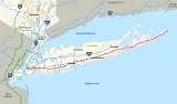
New York State Route 27 (NY 27) is an east–west 120.58 miles (194.05 km) long state highway
extending from Interstate 278 in the New York City borough
of Brooklyn
to Montauk Point State Park
on Long Island
, New York
, United States
. Its two most prominent components are Sunrise Highway and Montauk Highway
.
East of the interchange with the Heckscher State Parkway
in Islip Terrace
, NY 27 acts as the primary east–west highway on southern Long Island.
The entire route in Suffolk
, Nassau
, and Queens
was designated by the New York State Senate
as the POW/MIA Memorial Highway.
Every township on the South Shore
is accessible through Sunrise Highway.
 Route 27 begins at Interstate 278 (Gowanus Expressway) in the New York City
borough of Brooklyn
and uses the Prospect Expressway. This road is a short sunken highway that runs southeast through Park Slope
and Windsor Terrace
. Due to the space constraints of building in an already-urbanized area, the highway stretches a little over 2 miles (3.2 km) and has an inconsistent entrance-exit scheme. There are two exits going towards Ocean Parkway: one at 10th Avenue and 19th Street, the other at Greenwood Avenue and East 5th Street; it has an entrance on 17th Street between 4th and 5th Avenues and another entrance on 19th Street and 7th Avenue. In the opposite direction, there are exits at Ocean Parkway and Fort Hamilton Parkway, 8th Avenue and 18th Street, 4th Avenue and Prospect Avenue, and Hamilton Avenue and Prospect Avenue; there are entrances at Ocean Parkway and Fort Hamilton Parkway, and at 11th Avenue and Terrace Place. The eastbound entrance to the road from the Brooklyn-Queens Expressway is closed weekday mornings to facilitate traffic entering Manhattan.
From the south end of the Prospect Expressway, which continues south as Ocean Parkway
, NY 27 makes its way east to Linden Boulevard
via Caton Avenue. Eastbound traffic exits at Fifth Street and makes a left onto Caton Avenue, crossing over the Prospect Expressway, while westbound NY 27 turns south on Coney Island Avenue and west on Church Avenue to meet the expressway's south end. Eastbound trucks are directed to exit earlier, at 10th Avenue, and take McDonald Avenue south to Caton Avenue.
Linden Boulevard enters Queens
and merges into Conduit Avenue. Conduit Avenue soon splits as frontage road
s for the Belt Parkway
, running east past the north end of John F. Kennedy International Airport
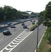
. Near the city line, the Belt Parkway turns north, and NY 27 becomes Sunrise Highway.
, passing through Valley Stream
and Rockville Centre
on its way to Merrick
, where it connects to the Meadowbrook State Parkway
by way of an interchange. NY 27 continues into Suffolk County
, where it veers to the northeast to bypass Copiague
to the north. At an interchange with NY 109
in West Babylon
, Sunrise Highway becomes a six-lane expressway with two two-lane service roads. The route continues on, meeting the Robert Moses Causeway
near West Islip
. In East Patchogue, New York
, the highway is reduced to a four-lane expressway after the NY 112
exit. Between County Route 16
in Brookhaven
and CR 46
in Shirley
, the median is lined with pine trees in front of South Haven County Park. The setting along these roads is similar to the one on the Southern State Parkway
west of Belmont Lake State Park
. The last exit that Sunrise Highway has with a state highway is near Hampton Bays
, where it meets NY 24
.
 East of NY 24, Sunrise Highway crosses over the Shinnecock Canal
and merges with County Route 39 to become North Highway, a four-lane undivided highway. The county-maintained highway continues east near the village of Southampton
before ending at an intersection with Montauk Highway
.
, where it becomes the Montauk Point State Parkway, a Robert Moses-designed highway leading to Montauk Point State Park
. This section is also shared by New York State Bicycle Route 27. It is two lanes wide, with the exception of some four-lane sections in some hamlets and the village of East Hampton
. Inside East Hampton Village, NY 27 becomes Woods Lane, and then Main Street. It has an intersection with the southern end of NY 114 before entering "downtown." After passing Newtown Lane and North Main Street, NY 27 changes names once again to Pantigo Road
, which is a historic district listed on the National Register of Historic Places
. In the hamlet of Amagansett, NY 27 changes back to Main Street, before becoming Montauk Point State Parkway east of Amagansett.
line to Amagansett
. It began at the point where Merrick Road
exited Queens
and entered Nassau County
and mostly followed Merrick Road and Montauk Highway
east to Amagansett. From East Patchogue
to Brookhaven
, NY 27 followed South Country Road instead, passing through the downtown section of the village of Bellport
. The NY 27 designation was extended eastward along Montauk Highway to Montauk Point by 1930. On February 24, 1930, South Country Road was added to the Suffolk County
highway system as County Route 36
. NY 27 was subsequently realigned to follow Montauk Highway between East Patchogue and Brookhaven.
Ca. 1931, NY 27 was realigned west of Oakdale
to follow Sunrise Boulevard, a new, parallel highway to Merrick Road and Montauk Highway, between the New York City line and Massapequa
and several local roads from Massapequa to Montauk Highway at Oakdale. The former routing of NY 27 from Massapequa
to Oakdale became NY 27A
, which connected to NY 27 in Massapequa by way of County Line Road. Sunrise Boulevard was extended eastward to Oakdale ca. 1934 as a realignment of NY 27. One portion of NY 27's former routing between NY 27A in Massapequa and the Suffolk County line is known as Old Sunrise Highway and remains state-maintained to this day as NY 900D, an unsigned reference route. Sunrise Highway was built over the Brooklyn Waterworks
aqueduct. Said aqueduct goes past the south side of Aqueduct Racetrack
.
, and Flatbush Avenue through Queens
and Brooklyn
to the Manhattan Bridge
, from where it continued into Manhattan
along Canal Street
to a terminus at 6th Avenue (then-U.S. Route 1A and later NY 1A
). The route was realigned slightly in the early 1940s to follow Atlantic and Washington Avenues, Eastern Parkway, Buffalo Avenue, and Rockaway Avenue between Flatbush Avenue and Linden Boulevard. NY 27 was altered again in the mid-1960s to continue west on Linden Boulevard, Caton Avenue, and Church Avenue to the south end of the Prospect Expressway. The route turned north here, following the freeway north to its end at the Gowanus Expressway (then-NY 27A), where NY 27A now ended. The Prospect Expressway was constructed during the 1950s, and was planned by Robert Moses
.
Prior to 1970, NY 27A continued north to the Holland Tunnel
in Manhattan by way of the Gowanus Expressway, the Brooklyn–Battery Tunnel, and the West Side Elevated Highway
. On January 1, 1970, NY 27A was truncated eastward to its current western terminus in Massapequa while NY 27 was extended northward along NY 27A's former routing to the Holland Tunnel, where it ended at Interstate 78 and NY 9A
. However, by 1973, NY 27 was cut back to its interchange with the Gowanus Expressway while Interstate 478 was assigned to both the Battery Tunnel and all of the West Side Elevated Highway south of the Lincoln Tunnel
.
developed plans for an elevated expressway along Sunrise Highway through Nassau County which was to feature 10 to 12 lanes. The downtown villages along the route effectively put a stop to the idea. This expressway would have provided a truck link for the South Shore
of Long Island.
 The portion of Sunrise Highway between North Lindenhurst
and the town of Southampton
was gradually upgraded into a limited-access highway. At the east end of the highway, Route 27 abruptly became a three-lane highway east of the Shinnecock Canal
at the point where NY 27 became concurrent with County Route 39. This area was known as the "Shinnecock Squeeze" as traffic on the two-lane NY 27 eastbound was "squeezed" into a single lane. In 2006 and 2007 Suffolk County and Southampton officials began using traffic cone
s to adjust the lanes
to accommodate peak travel in what was called the "traffic cone program." At the end of summer 2007, work began on adding another eastbound lane to North Sea Road. The construction snarled traffic on CR 39 and the Long Island Rail Road
added three trains each way going from Speonk to East Hampton during the construction. The new eastbound lane opened in April 2008.
came in the 1950s. In 1969, the New York Legislature
approved a $160 million plan for the extension for the limited access route to be flanked by bicycle and equestrian trails. The eastbound and westbound roadways were to be separated by wide wooded medians. For the most part, the road would have run a mile or two to the north of existing Route 27, thus avoiding the populated centers through which it now goes. The extended Sunrise Highway would have had interchanges with County Route 38 (North Sea Road) and County Route 39 (County Road), County Route 79 (Bridgehampton-Sag Harbor Road), NY 114
(East Hampton-Sag Harbor Turnpike), County Route 40 (Three Mile Harbor Road), and County Route 45 (Amagansett-Springs Road) before merging back into the existing Montauk Highway. The exits would have been sequentially numbered from 67 to 72. The plan failed and Governor Hugh Carey
cancelled it in 1975. Other suggestions have included building a limited-access road on either side of the Long Island Rail Road Montauk Branch
.
Plans to construct a cloverleaf interchange
with Suffolk County Route 2 (Straight Path) in Copiague
have existed for some time. However, in recent years, planners have realized that such an interchange would be too close to the cloverleafs with Suffolk County Route 47 (Great Neck Road) to the west and Suffolk County Route 3 (Wellwood Road) to the east. To further complicate matters, a widened Suffolk County Route 28 was extended to Sunrise Highway near the Straight Path intersection in the late-1980s. No interchange has been built yet for this area.
The Oakdale Merge is a convergence of Sunrise Highway and Montauk Highway
between Great River
and Oakdale
abutting the southern edge of Connetquot River State Park. The Montauk Highway predates the Sunrise Highway in the area. When Sunrise Highway was extended east of Amityville in 1940, it terminated at Montauk Highway at the entrance to Connetquot River State Park.
In 1953, Sunrise Highway was extended to East Patchogue; a 0.5 mi (0.80467 km) overlap of New York State Routes 27 and 27A
was created, with at-grade intersections connecting the highways. A segment of this alignment remains south of the eastern interchange. Route 27A was truncated east of the overlap in 1972.
Plans to upgrade the interchange have existed since its creation. During the early-1960s, the Suffolk County Department of Public Works considered designating a county highway to connect Nicoll's Road
in Lake Grove through Long Island MacArthur Airport
to the east end of the merge. As recently as 1981, the New York State Department of Transportation
planned to add service roads and a proper interchange at both ends of the merge. However, pressure from environmental groups seeking to avoid damaging the parkland stalled construction. NYSDOT eventually reconstructed Sunrise Highway in eastern Islip township into a freeway during the 1990s, resulting in the present configuration. The entrance to Connetquot River Park remained as an at-grade intersection, accessible only from the westbound lane. Former segments of Montauk Highway now exist on both sides of the interchange, and sections of both roads were converted into fishing areas owned by the New York State Department of Environmental Conservation
. The east end of the merge was the scene of numerous accidents, resulting in its reconstruction in 1999; a new off-ramp to the service road for Pond Road was built, resulting in a renumbering of Exit 47 as Exit 46A.
While none of the interchanges north of Patchogue
were built until the period between 1988 and 1993, the New York State Department of Transportation
(NYSDOT) had known the need for them and planned them decades before their eventual construction.
West of the Carmans River
near Southaven County Park
in South Haven
, there was once a plan to combine the eastbound service road with Montauk Highway
, in a similar manner to that of the Oakdale Merge.
 NY 27A
(17.31 miles or 27.86 km) is an alternate route of NY 27 across southern Long Island
from Massapequa Park
to Oakdale
, accessing Babylon
and Islip
. It was assigned ca. 1931.
|rowspan=9|Kings
|rowspan=9|Brooklyn
|0.00
|
|
|Exit 24 (I-278)
|-
|0.01
|1
|Hamilton Avenue
|Westbound exit only
|-
|0.24
|2
|3rd Avenue
, 4th Avenue
|Eastbound entrance and westbound exit
|-
|0.61
|3
|7th Avenue, 8th Avenue
|Eastbound entrance and westbound exit
|-
|0.91
|4
|10th Avenue, 11th Avenue
|Eastbound exit and westbound entrance. All trucks to NY-27 eastbound must exit
|-
|1.45
|5
|Fort Hamilton Parkway
|NY 27 leaves the Prospect Expressway eastbound
|-
|1.76
|6
|Church Avenue
|Eastbound exit and westbound entrance. NY 27 joins the Prospect Expressway westbound. Commercial vehicles leave eastbound, enter westbound
|-
|1.76
|
|Ocean Parkway
|Continuation of Prospect Expressway beyond Church Avenue
|-
|colspan=4 align="center"|East end of freeway section
|-
|rowspan=3|Queens
|Howard Beach
|9.03
|
|
|Exit 17 (Belt Parkway)
|-
|South Ozone Park
|11.51
|
|
|Southern terminus of I-678; northern terminus of NY 878
|-
|Laurelton
|14.71
|
|
|Exit 23B (Belt Parkway)
|-
|rowspan=5|Nassau
|Freeport
|23.89
|
|
|Exit M8 (Meadowbrook Parkway)
|-
|Wantagh
|26.73
|
|
|Exit W5 (Wantagh Parkway)
|-
|Seaford
|27.93
|
|
|Exit 2 (NY 135)
|-
|Massapequa
|28.83
|
|
|
|-
|Massapequa Park
|31.04
|
|
|Western terminus of NY 27A
|-
|rowspan=46|Suffolk
|Amityville
|32.07
|
|
|Interchange
|-
|Copiague
|32.94
|
|
|Interchange
|-
|rowspan=3|North Lindenhurst
|34.17
|
|
|Interchange
|-
|colspan=4 align="center"|West end of freeway section
|-
|35.32
|37
|
|
|-
|rowspan=2|West Babylon
|36.45
|38
|Little East Neck Road / Belmont Avenue
|
|-
|36.93
|39
|Hubbards Path
|
|-
|North Babylon
|38.26
|40
|
|
|-
|West Islip
|39.75
|41
|
|Exit RM1 (Robert Moses Causeway)
|-
|rowspan=2|Brightwaters
|
|42
|Manor Lane
|Westbound exit and eastbound entrance
|-
|41.13
|43
|
|
|-
|Bay Shore
|42.40
|44
|Brentwood Road – Brentwood
, Bay Shore
|
|-
|Islip
|44.06
|45
|
|
|-
|rowspan=3|East Islip
|45.74
|rowspan=2|46
|
|Eastbound exit and entrance; exit 44 (SSP/HSP); eastern terminus of Southern Parkway; western terminus of Heckscher Parkway
|-
|
|
|Westbound exit and entrance
|-
|47.41
|46A
|
|Eastbound exit only; eastern terminus of NY 27A; western terminus of CR 85
|-
|rowspan=3|Oakdale
|
|47
|Pond Road south
|Eastbound exit only
|-
|
|47A
|Oakdale–Bohemia Road – Bohemia
, Oakdale
|Eastbound exit and westbound entrance
|-
|50.16
|48
|Locust Avenue – Bohemia
, Oakdale
|
|-
|rowspan=3|Bohemia
|51.06
|49
|
|To Long Island MacArthur Airport
via Johnson Avenue
|-
|
|50A
|Johnson Avenue – Sayville
, Bohemia
|Westbound exit only; to Long Island MacArthur Airport
; formerly CR 112
|-
|
|50
|Lincoln Avenue – Ronkonkoma
, Sayville
|No westbound entrance
|-
|Bayport
|52.44
|51
|
|No access to NY 454 eastbound; eastern terminus of NY 454; to Long Island MacArthur Airport
|-
|rowspan=4|Patchogue
|54.07
|52
|
|
|-
|54.82
|52A
|
|Eastbound exit and westbound entrance; southern terminus of CR 83
|-
|55.31
|53
|
|To CR 83
(westbound NY 27)
|-
|56.72
|54
|Hospital Road – East Patchogue
|To Brookhaven Memorial Hospital
|-
|rowspan=2|Bellport
|57.48
|55
|
|
|-
|58.42
|56
|Station Road – Bellport
, Yaphank
|
|-
|Brookhaven
|60.47
|57N-S
|
|Partial cloverleaf
at Horse Block Road; east-to-south off-ramp and south-to-west on-ramp at Yaphank Avenue
|-
|Shirley
|62.65
|58N-S
|
|To Smith Point County Park
, Brookhaven Airport
, and Brookhaven National Laboratory
|-
|rowspan=2|Moriches
|66.35
|59
|Wading River Road – Wading River
, Center Moriches
|Formerly CR 25
|-
|67.28
|60
|Railroad Avenue – Chapman Boulevard, Center Moriches
, Manorville
|Westbound exit and eastbound entrance
|-
|rowspan=2|Eastport
|69.60
|61
|
|Eastbound exit and westbound entrance
|-
|70.96
|62
|
|Formerly proposed Port Jefferson-Westhampton Beach Highway; originally planned as a cloverleaf interchange
with collector/distributor roads
|-
|rowspan=2|N of Quogue
|75.47
|63N-S
|
|To Francis S. Gabreski Airport
|-
|76.95
|64N-S
|
|Formerly NY 113
|-
|Hampton Bays
|81.15
|65N-S
|
|
|-
|rowspan=5|Southampton
|82.94
|66
|
|Quarter-cloverleaf interchange
s
|-
|
|
|
|Westbound exit and eastbound entrance; west end of NY 27 / CR 39 overlap
|-
|colspan=4 align="center"|East end of freeway section
|-
|
|
|David Whites Lane
|Eastern terminus of CR 39; western terminus of CR 39A
|-
|89.68
|
|Montauk Highway
|Eastern terminus of CR 39A and NY 27 / CR 39A overlap
|-
|Bridgehampton
|
|
|
|Southern terminus of CR 79
|-
|East Hampton
|100.17
|
|
|Southern terminus of NY 114
|-
|Montauk
|120.58
|
|Montauk Point State Park
|
State highway
State highway, state road or state route can refer to one of three related concepts, two of them related to a state or provincial government in a country that is divided into states or provinces :#A...
extending from Interstate 278 in the New York City borough
Borough (New York City)
New York City, one of the largest cities in the world, is composed of five boroughs. Each borough now has the same boundaries as the county it is in. County governments were dissolved when the city consolidated in 1898, along with all city, town, and village governments within each county...
of Brooklyn
Brooklyn
Brooklyn is the most populous of New York City's five boroughs, with nearly 2.6 million residents, and the second-largest in area. Since 1896, Brooklyn has had the same boundaries as Kings County, which is now the most populous county in New York State and the second-most densely populated...
to Montauk Point State Park
Montauk Point State Park
Montauk Point State Park is located in the hamlet of Montauk, at the eastern tip of Long Island in the Town of East Hampton, Suffolk County, New York. Montauk Point is the easternmost extremity of the South Fork of Long Island, and thus also of New York State...
on Long Island
Long Island
Long Island is an island located in the southeast part of the U.S. state of New York, just east of Manhattan. Stretching northeast into the Atlantic Ocean, Long Island contains four counties, two of which are boroughs of New York City , and two of which are mainly suburban...
, New York
New York
New York is a state in the Northeastern region of the United States. It is the nation's third most populous state. New York is bordered by New Jersey and Pennsylvania to the south, and by Connecticut, Massachusetts and Vermont to the east...
, United States
United States
The United States of America is a federal constitutional republic comprising fifty states and a federal district...
. Its two most prominent components are Sunrise Highway and Montauk Highway
Montauk Highway
Montauk Highway is one of the original through highways of Long Island, New York, extending from Jamaica, in the New York City borough of Queens to Montauk Point in Suffolk County, a distance of approximately 100 miles ....
.
East of the interchange with the Heckscher State Parkway
Heckscher State Parkway
The Heckscher State Parkway is an long parkway in Suffolk County, New York. The western terminus is at the Sagtikos State Parkway in West Islip, where it continues west as the Southern State Parkway. The eastern terminus is at the entrance to Heckscher State Park in Great River...
in Islip Terrace
Islip Terrace, New York
Islip Terrace is a hamlet and census-designated place in Suffolk County, New York, United States. The population was 5,641 at the 2000 census.-History:...
, NY 27 acts as the primary east–west highway on southern Long Island.
The entire route in Suffolk
Suffolk County, New York
Suffolk County is a county located in the U.S. state of New York on the eastern portion of Long Island. As of the 2010 census, the population was 1,493,350. It was named for the county of Suffolk in England, from which its earliest settlers came...
, Nassau
Nassau County, New York
Nassau County is a suburban county on Long Island, east of New York City in the U.S. state of New York, within the New York Metropolitan Area. As of the 2010 census, the population was 1,339,532...
, and Queens
Queens
Queens is the easternmost of the five boroughs of New York City. The largest borough in area and the second-largest in population, it is coextensive with Queens County, an administrative division of New York state, in the United States....
was designated by the New York State Senate
New York State Senate
The New York State Senate is one of two houses in the New York State Legislature and has members each elected to two-year terms. There are no limits on the number of terms one may serve...
as the POW/MIA Memorial Highway.
Every township on the South Shore
South Shore (Long Island)
The South Shore of Long Island, in the U.S. state of New York, is the area along Long Island's Atlantic Ocean shoreline. Though some consider the South Shore to include parts of Queens, particularly the beach communities in the Rockaways such as Belle Harbor, the term is generally used to refer to...
is accessible through Sunrise Highway.
New York City
New York City
New York is the most populous city in the United States and the center of the New York Metropolitan Area, one of the most populous metropolitan areas in the world. New York exerts a significant impact upon global commerce, finance, media, art, fashion, research, technology, education, and...
borough of Brooklyn
Brooklyn
Brooklyn is the most populous of New York City's five boroughs, with nearly 2.6 million residents, and the second-largest in area. Since 1896, Brooklyn has had the same boundaries as Kings County, which is now the most populous county in New York State and the second-most densely populated...
and uses the Prospect Expressway. This road is a short sunken highway that runs southeast through Park Slope
Park Slope, Brooklyn
Park Slope is a neighborhood in western Brooklyn, New York City's most populous borough. Park Slope is roughly bounded by Prospect Park West to the east, Fourth Avenue to the west, Flatbush Avenue to the north, and 15th Street to the south, though other definitions are sometimes offered. Generally...
and Windsor Terrace
Windsor Terrace, Brooklyn
Windsor Terrace is a neighborhood in the New York City borough of Brooklyn. It is bounded by Prospect Park to the northeast and Green-Wood Cemetery, a National Historic Landmark, to the southwest. Its southeastern boundary is Caton Avenue, while to the northwest it is bordered by Prospect Park West...
. Due to the space constraints of building in an already-urbanized area, the highway stretches a little over 2 miles (3.2 km) and has an inconsistent entrance-exit scheme. There are two exits going towards Ocean Parkway: one at 10th Avenue and 19th Street, the other at Greenwood Avenue and East 5th Street; it has an entrance on 17th Street between 4th and 5th Avenues and another entrance on 19th Street and 7th Avenue. In the opposite direction, there are exits at Ocean Parkway and Fort Hamilton Parkway, 8th Avenue and 18th Street, 4th Avenue and Prospect Avenue, and Hamilton Avenue and Prospect Avenue; there are entrances at Ocean Parkway and Fort Hamilton Parkway, and at 11th Avenue and Terrace Place. The eastbound entrance to the road from the Brooklyn-Queens Expressway is closed weekday mornings to facilitate traffic entering Manhattan.
From the south end of the Prospect Expressway, which continues south as Ocean Parkway
Ocean Parkway (Brooklyn)
Ocean Parkway is a broad boulevard in the west central portion of the borough of Brooklyn in New York City.-Route description:Ocean Parkway extends over a distance of about five miles , running almost north to south from the vicinity of Prospect Park to Brighton Beach...
, NY 27 makes its way east to Linden Boulevard
Linden Boulevard
Linden Boulevard is a boulevard in New York City. It starts off at Flatbush Avenue in Brooklyn and stretches through both Brooklyn and Queens. This boulevard, especially the area of Cambria Heights between Springfield Boulevard and the Nassau County line represents a smaller version of shopping...
via Caton Avenue. Eastbound traffic exits at Fifth Street and makes a left onto Caton Avenue, crossing over the Prospect Expressway, while westbound NY 27 turns south on Coney Island Avenue and west on Church Avenue to meet the expressway's south end. Eastbound trucks are directed to exit earlier, at 10th Avenue, and take McDonald Avenue south to Caton Avenue.
Linden Boulevard enters Queens
Queens
Queens is the easternmost of the five boroughs of New York City. The largest borough in area and the second-largest in population, it is coextensive with Queens County, an administrative division of New York state, in the United States....
and merges into Conduit Avenue. Conduit Avenue soon splits as frontage road
Frontage road
A frontage road is a non-limited access road running parallel to a higher-speed road, usually a freeway, and feeding it at appropriate points of access...
s for the Belt Parkway
Belt Parkway
The Belt System is a series of connected limited-access highways that form a belt-like circle around the New York City boroughs of Brooklyn and Queens. The system comprises four officially separate parkways; however, three of the four are signed as the Belt Parkway...
, running east past the north end of John F. Kennedy International Airport
John F. Kennedy International Airport
John F. Kennedy International Airport is an international airport located in the borough of Queens in New York City, about southeast of Lower Manhattan. It is the busiest international air passenger gateway to the United States, handling more international traffic than any other airport in North...
. Near the city line, the Belt Parkway turns north, and NY 27 becomes Sunrise Highway.
Sunrise Highway
Sunrise Highway begins in eastern Queens as a six to eight lane arterial. It heads east into Nassau CountyNassau County, New York
Nassau County is a suburban county on Long Island, east of New York City in the U.S. state of New York, within the New York Metropolitan Area. As of the 2010 census, the population was 1,339,532...
, passing through Valley Stream
Valley Stream, New York
Valley Stream is a village in Nassau County, New York in the United States. The population in the village of Valley Stream was 37,511 at the 2010 census...
and Rockville Centre
Rockville Centre, New York
Rockville Centre is a village located in Nassau County, New York, in the United States. As of the 2010 census, the village had a total population of 24,023. The town is made up of middle to upper middle class residents, most of the wealthier residents residing on the north side of town near the...
on its way to Merrick
Merrick, New York
Merrick is a hamlet in the Town of Hempstead in Nassau County, New York, USA. As of the 2010 census, the CDP population was 22,097. The name "Merrick" is taken from Meroke, the name of the Algonquian tribe formerly indigenous to the area...
, where it connects to the Meadowbrook State Parkway
Meadowbrook State Parkway
The Meadowbrook State Parkway is a long parkway in Nassau County, New York. The southern terminus is at the Bay Parkway in Jones Beach State Park, where the parkway becomes the Ocean Parkway. The northern terminus is at the Northern State Parkway in Carle Place...
by way of an interchange. NY 27 continues into Suffolk County
Suffolk County, New York
Suffolk County is a county located in the U.S. state of New York on the eastern portion of Long Island. As of the 2010 census, the population was 1,493,350. It was named for the county of Suffolk in England, from which its earliest settlers came...
, where it veers to the northeast to bypass Copiague
Copiague, New York
Copiague is a hamlet in Suffolk County, New York, United States. The population was 18,037 at the 2007 census. Once Copiague was a thriving Italian community. Many years ago a part of Copiague was named after Marconi. The ethnic makeup of the hamlet is quite diverse, making Copiague a rich...
to the north. At an interchange with NY 109
New York State Route 109
New York State Route 109 , also known as the Babylon–Farmingdale Turnpike, is a four-lane state highway on Long Island in New York in the United States. It runs from Farmingdale in the Nassau County town of Oyster Bay to the village of Babylon in Suffolk County...
in West Babylon
West Babylon, New York
West Babylon is a census-designated place in the town of Babylon in Suffolk County, New York, United States. The population was 43,452 at the 2000 census.-Geography:West Babylon is located at ....
, Sunrise Highway becomes a six-lane expressway with two two-lane service roads. The route continues on, meeting the Robert Moses Causeway
Robert Moses Causeway
The Robert Moses Causeway is an long parkway in Suffolk County, New York. The parkway, originally known as the Captree Causeway, connects West Islip on Long Island to the barrier beach islands, such as Captree Island, Jones Beach Island, and the western tip of Fire Island, to the south. It is...
near West Islip
West Islip, New York
West Islip is a hamlet and CDP, located in Suffolk County, New York, USA. Situated on the south shore of Long Island, the population of the CDP was 29,907 at the time of the 2000 census.-Geography:West Islip is located at ....
. In East Patchogue, New York
East Patchogue, New York
East Patchogue is a census-designated place in the Suffolk County town of Brookhaven, New York, United States. The population was 20,824 at the 2000 census. The CDP is a proximate representation of the East Patchogue hamlet used for statistical purposes of the Census Bureau...
, the highway is reduced to a four-lane expressway after the NY 112
New York State Route 112
New York State Route 112 is a New York state highway, entirely within the Town of Brookhaven in Suffolk County. It runs from Montauk Highway, formerly part of NY 27A, in the village of Patchogue to NY 25A in Port Jefferson Station. It is known locally as Medford Ave in Patchogue...
exit. Between County Route 16
County Route 16 (Suffolk County, New York)
Suffolk County Route 16 is a main thoroughfare through central Suffolk County, New York. Its western terminus is at Middle Country Road in Smithtown, on the eastern border of the Village of the Branch, and its eastern terminus is at Montauk Highway in Brookhaven near Southhaven...
in Brookhaven
Brookhaven, New York
The Town of Brookhaven is one of the ten towns into which Suffolk County, New York, United States, has been divided. Part of the New York metropolitan area, it is located in central Suffolk County and is the only town in the county that stretches from the North Shore to the South Shore of Long...
and CR 46
County Route 46 (Suffolk County, New York)
Suffolk County Road 46 is a major county road in eastern Suffolk County, New York. It runs north and south from County Route 75 in Smith Point County Park to New York State Route 25A near the border of Shoreham and Wading River...
in Shirley
Shirley, New York
Shirley is a hamlet in Suffolk County, New York, United States. As of the 2000 census, Shirley population was 26,395....
, the median is lined with pine trees in front of South Haven County Park. The setting along these roads is similar to the one on the Southern State Parkway
Southern State Parkway
The Southern State Parkway is a long limited-access highway on Long Island, in the U.S. state of New York...
west of Belmont Lake State Park
Belmont Lake State Park
Belmont Lake State Park is located in Babylon , New York on Long Island in Suffolk County, New York. The park has boating and picnicking facilities and playing fields for popular sports...
. The last exit that Sunrise Highway has with a state highway is near Hampton Bays
Hampton Bays, New York
Hampton Bays is a hamlet in Suffolk County, New York, United States. The population was 12,236 at the 2000 census.Hampton Bays is in the Town of Southampton.-Geography:...
, where it meets NY 24
New York State Route 24
New York State Route 24 is an east–west state highway on Long Island in New York in the United States. The route is split into two segments, with the longest and westernmost of the two extending from Interstate 295 and NY 25 in the Queens Village section of the New York City...
.
Shinnecock Canal
The Shinnecock Canal is a canal that cuts across the South Fork of Long Island at Hampton Bays, New York. At long, it connects Great Peconic Bay and the north fork of Long Island with Shinnecock Bay and the Atlantic Ocean...
and merges with County Route 39 to become North Highway, a four-lane undivided highway. The county-maintained highway continues east near the village of Southampton
Southampton (village), New York
Southampton is a village in Suffolk County, New York, USA. The village is named after the Earl of Southampton. The Village of Southampton is in the southeast part of the county in the Town of Southampton...
before ending at an intersection with Montauk Highway
Montauk Highway
Montauk Highway is one of the original through highways of Long Island, New York, extending from Jamaica, in the New York City borough of Queens to Montauk Point in Suffolk County, a distance of approximately 100 miles ....
.
Montauk Highway
Montauk Highway is the name that NY 27 carries from just east of Southampton by the Princess Diner to the east side of MontaukMontauk, New York
Montauk [ˈmɒntɒk] is a census-designated place that roughly corresponds to the hamlet with the same name located in the town of East Hampton in Suffolk County, New York, United States on the South Shore of Long Island. As of the United States 2000 Census, the CDP population was 3,851 as of 2000...
, where it becomes the Montauk Point State Parkway, a Robert Moses-designed highway leading to Montauk Point State Park
Montauk Point State Park
Montauk Point State Park is located in the hamlet of Montauk, at the eastern tip of Long Island in the Town of East Hampton, Suffolk County, New York. Montauk Point is the easternmost extremity of the South Fork of Long Island, and thus also of New York State...
. This section is also shared by New York State Bicycle Route 27. It is two lanes wide, with the exception of some four-lane sections in some hamlets and the village of East Hampton
East Hampton (village), New York
The Village of East Hampton is a village in Town of East Hampton, New York. It is located in Suffolk County, on the South Fork of eastern Long Island...
. Inside East Hampton Village, NY 27 becomes Woods Lane, and then Main Street. It has an intersection with the southern end of NY 114 before entering "downtown." After passing Newtown Lane and North Main Street, NY 27 changes names once again to Pantigo Road
Pantigo Road Historic District
The Pantigo Road Historic District is a historic district in the Village of East Hampton, on Long Island, New York. It is located on a segment of New York State Route 27 named Pantigo Road, and was listed on the National Register of Historic Places on July 21, 1988.The Thomas Moran House, a...
, which is a historic district listed on the National Register of Historic Places
National Register of Historic Places
The National Register of Historic Places is the United States government's official list of districts, sites, buildings, structures, and objects deemed worthy of preservation...
. In the hamlet of Amagansett, NY 27 changes back to Main Street, before becoming Montauk Point State Parkway east of Amagansett.
Designation and early realignments
NY 27 was assigned in the mid-1920s and initially extended from the New York CityNew York City
New York is the most populous city in the United States and the center of the New York Metropolitan Area, one of the most populous metropolitan areas in the world. New York exerts a significant impact upon global commerce, finance, media, art, fashion, research, technology, education, and...
line to Amagansett
Amagansett, New York
Amagansett is a census-designated place that roughly corresponds to the hamlet by the same name in the town of East Hampton in Suffolk County, New York on the South Shore of Long Island. As of the United States 2000 Census, the CDP population was 1,067. Amagansett hamlet was founded in 1680.The...
. It began at the point where Merrick Road
Merrick Road
Merrick Road, named Merrick Boulevard inside New York City, is a road running from Jamaica, Queens, New York east through Merrick, New York to the line between Nassau and Suffolk Counties, where it becomes Montauk Highway. A bit of it at the east end is signed and maintained by the New York State...
exited Queens
Queens
Queens is the easternmost of the five boroughs of New York City. The largest borough in area and the second-largest in population, it is coextensive with Queens County, an administrative division of New York state, in the United States....
and entered Nassau County
Nassau County, New York
Nassau County is a suburban county on Long Island, east of New York City in the U.S. state of New York, within the New York Metropolitan Area. As of the 2010 census, the population was 1,339,532...
and mostly followed Merrick Road and Montauk Highway
Montauk Highway
Montauk Highway is one of the original through highways of Long Island, New York, extending from Jamaica, in the New York City borough of Queens to Montauk Point in Suffolk County, a distance of approximately 100 miles ....
east to Amagansett. From East Patchogue
East Patchogue, New York
East Patchogue is a census-designated place in the Suffolk County town of Brookhaven, New York, United States. The population was 20,824 at the 2000 census. The CDP is a proximate representation of the East Patchogue hamlet used for statistical purposes of the Census Bureau...
to Brookhaven
Brookhaven, New York
The Town of Brookhaven is one of the ten towns into which Suffolk County, New York, United States, has been divided. Part of the New York metropolitan area, it is located in central Suffolk County and is the only town in the county that stretches from the North Shore to the South Shore of Long...
, NY 27 followed South Country Road instead, passing through the downtown section of the village of Bellport
Bellport, New York
Bellport is a village in Suffolk County, New York, United States. The population was 2,363 at the 2000 census. The village is named after the Bell family, early settlers of the area. The public education system in Bellport makes up the South Country Central School District consisting of six...
. The NY 27 designation was extended eastward along Montauk Highway to Montauk Point by 1930. On February 24, 1930, South Country Road was added to the Suffolk County
Suffolk County, New York
Suffolk County is a county located in the U.S. state of New York on the eastern portion of Long Island. As of the 2010 census, the population was 1,493,350. It was named for the county of Suffolk in England, from which its earliest settlers came...
highway system as County Route 36
County Route 36 (Suffolk County, New York)
Suffolk County Road 36 is a county road in Central-Southern Suffolk County, New York. Though it is signed as an east–west road, it runs southeast to north from Suffolk County Road 80 and Lake Drive in East Patchogue back to Montauk Highway in Brookhaven...
. NY 27 was subsequently realigned to follow Montauk Highway between East Patchogue and Brookhaven.
Ca. 1931, NY 27 was realigned west of Oakdale
Oakdale, New York
Oakdale is a hamlet in Suffolk County, New York, United States. The population was 8,075 at the 2000 census. Oakdale is in the Town of Islip.- History :...
to follow Sunrise Boulevard, a new, parallel highway to Merrick Road and Montauk Highway, between the New York City line and Massapequa
Massapequa, New York
Massapequa is a hamlet located in the suburban Nassau County, New York. As of the 2010 census, the CDP had a total population of 21,685.Massapequa is located on the South Shore of Long Island....
and several local roads from Massapequa to Montauk Highway at Oakdale. The former routing of NY 27 from Massapequa
Massapequa, New York
Massapequa is a hamlet located in the suburban Nassau County, New York. As of the 2010 census, the CDP had a total population of 21,685.Massapequa is located on the South Shore of Long Island....
to Oakdale became NY 27A
New York State Route 27A
New York State Route 27A is a state highway extending from Massapequa in Nassau County to Oakdale in Suffolk County on Long Island, New York in the United States...
, which connected to NY 27 in Massapequa by way of County Line Road. Sunrise Boulevard was extended eastward to Oakdale ca. 1934 as a realignment of NY 27. One portion of NY 27's former routing between NY 27A in Massapequa and the Suffolk County line is known as Old Sunrise Highway and remains state-maintained to this day as NY 900D, an unsigned reference route. Sunrise Highway was built over the Brooklyn Waterworks
Brooklyn Waterworks
The Brooklyn Waterworks, also known as the Milburn Pumping Station, was an historic building in Freeport, Long Island. Designed by noted Brooklyn architect Frank Freeman and completed in 1890, it was described as "Long Island's most ambitious Romanesque Revival design."After the Waterworks was...
aqueduct. Said aqueduct goes past the south side of Aqueduct Racetrack
Aqueduct Racetrack
Aqueduct Racetrack is a thoroughbred horse-racing facility and racino in Ozone Park, Queens, New York. Its racing meets usually are from late October/early November through April.-History:...
.
New York City
In December 1934, the route was extended west into New York City. NY 27 followed Sunrise Highway, Linden BoulevardLinden Boulevard
Linden Boulevard is a boulevard in New York City. It starts off at Flatbush Avenue in Brooklyn and stretches through both Brooklyn and Queens. This boulevard, especially the area of Cambria Heights between Springfield Boulevard and the Nassau County line represents a smaller version of shopping...
, and Flatbush Avenue through Queens
Queens
Queens is the easternmost of the five boroughs of New York City. The largest borough in area and the second-largest in population, it is coextensive with Queens County, an administrative division of New York state, in the United States....
and Brooklyn
Brooklyn
Brooklyn is the most populous of New York City's five boroughs, with nearly 2.6 million residents, and the second-largest in area. Since 1896, Brooklyn has had the same boundaries as Kings County, which is now the most populous county in New York State and the second-most densely populated...
to the Manhattan Bridge
Manhattan Bridge
The Manhattan Bridge is a suspension bridge that crosses the East River in New York City, connecting Lower Manhattan with Brooklyn . It was the last of the three suspension bridges built across the lower East River, following the Brooklyn and the Williamsburg bridges...
, from where it continued into Manhattan
Manhattan
Manhattan is the oldest and the most densely populated of the five boroughs of New York City. Located primarily on the island of Manhattan at the mouth of the Hudson River, the boundaries of the borough are identical to those of New York County, an original county of the state of New York...
along Canal Street
Canal Street (Manhattan)
Canal Street is a major street in New York City, crossing lower Manhattan to join New Jersey in the west to Brooklyn in the east . It forms the main spine of Chinatown, and separates it from Little Italy...
to a terminus at 6th Avenue (then-U.S. Route 1A and later NY 1A
New York State Route 1A
New York State Route 1A was a state highway in New York City, running from the Holland Tunnel to U.S. Route 1 . It existed from 1934, when routes were first marked in New York City, until the 1960s.-History:...
). The route was realigned slightly in the early 1940s to follow Atlantic and Washington Avenues, Eastern Parkway, Buffalo Avenue, and Rockaway Avenue between Flatbush Avenue and Linden Boulevard. NY 27 was altered again in the mid-1960s to continue west on Linden Boulevard, Caton Avenue, and Church Avenue to the south end of the Prospect Expressway. The route turned north here, following the freeway north to its end at the Gowanus Expressway (then-NY 27A), where NY 27A now ended. The Prospect Expressway was constructed during the 1950s, and was planned by Robert Moses
Robert Moses
Robert Moses was the "master builder" of mid-20th century New York City, Long Island, Rockland County, and Westchester County, New York. As the shaper of a modern city, he is sometimes compared to Baron Haussmann of Second Empire Paris, and is one of the most polarizing figures in the history of...
.
Prior to 1970, NY 27A continued north to the Holland Tunnel
Holland Tunnel
The Holland Tunnel is a highway tunnel under the Hudson River connecting the island of Manhattan in New York City with Jersey City, New Jersey at Interstate 78 on the mainland. Unusual for an American public works project, it is not named for a government official, politician, or local hero or...
in Manhattan by way of the Gowanus Expressway, the Brooklyn–Battery Tunnel, and the West Side Elevated Highway
West Side Elevated Highway
The West Side Elevated Highway was an elevated section of Route NY-9A running along the Hudson River in the New York City borough of Manhattan to the tip of the island.It was an elevated highway, one of the first urban freeways in the world, and served as a...
. On January 1, 1970, NY 27A was truncated eastward to its current western terminus in Massapequa while NY 27 was extended northward along NY 27A's former routing to the Holland Tunnel, where it ended at Interstate 78 and NY 9A
New York State Route 9A
New York State Route 9A is a state highway in the vicinity of New York City, New York, United States. Its southern terminus is at the northern end of the Brooklyn–Battery Tunnel in New York City, where it intersects with both Interstate 478 and FDR Drive. The northern terminus of...
. However, by 1973, NY 27 was cut back to its interchange with the Gowanus Expressway while Interstate 478 was assigned to both the Battery Tunnel and all of the West Side Elevated Highway south of the Lincoln Tunnel
Lincoln Tunnel
The Lincoln Tunnel is a long tunnel under the Hudson River, connecting Weehawken, New Jersey and the borough of Manhattan in New York City.-History:...
.
Long Island
Robert MosesRobert Moses
Robert Moses was the "master builder" of mid-20th century New York City, Long Island, Rockland County, and Westchester County, New York. As the shaper of a modern city, he is sometimes compared to Baron Haussmann of Second Empire Paris, and is one of the most polarizing figures in the history of...
developed plans for an elevated expressway along Sunrise Highway through Nassau County which was to feature 10 to 12 lanes. The downtown villages along the route effectively put a stop to the idea. This expressway would have provided a truck link for the South Shore
South Shore (Long Island)
The South Shore of Long Island, in the U.S. state of New York, is the area along Long Island's Atlantic Ocean shoreline. Though some consider the South Shore to include parts of Queens, particularly the beach communities in the Rockaways such as Belle Harbor, the term is generally used to refer to...
of Long Island.
North Lindenhurst, New York
North Lindenhurst is a hamlet in Suffolk County, New York, United States. The population was 11,767 at the 2000 census. It is a community in the Town of Babylon...
and the town of Southampton
Southampton (town), New York
The Town of Southampton is located in southeastern Suffolk County, New York, U.S., partly on the South Fork of Long Island. As of the United States 2000 Census, the town had a total population of 54,712...
was gradually upgraded into a limited-access highway. At the east end of the highway, Route 27 abruptly became a three-lane highway east of the Shinnecock Canal
Shinnecock Canal
The Shinnecock Canal is a canal that cuts across the South Fork of Long Island at Hampton Bays, New York. At long, it connects Great Peconic Bay and the north fork of Long Island with Shinnecock Bay and the Atlantic Ocean...
at the point where NY 27 became concurrent with County Route 39. This area was known as the "Shinnecock Squeeze" as traffic on the two-lane NY 27 eastbound was "squeezed" into a single lane. In 2006 and 2007 Suffolk County and Southampton officials began using traffic cone
Traffic cone
Traffic cones, also called traffic pylons, road cones, highway cones, safety cones, construction cones or witches' hats or safety wizards, are usually cone-shaped markers that are placed on roads or footpaths to temporarily redirect traffic in a safe manner...
s to adjust the lanes
Reversible lane
A reversible lane , called a counterflow lane or contraflow lane in transport engineering nomenclature, is a lane in which traffic may travel in either direction, depending on certain conditions...
to accommodate peak travel in what was called the "traffic cone program." At the end of summer 2007, work began on adding another eastbound lane to North Sea Road. The construction snarled traffic on CR 39 and the Long Island Rail Road
Long Island Rail Road
The Long Island Rail Road or LIRR is a commuter rail system serving the length of Long Island, New York. It is the busiest commuter railroad in North America, serving about 81.5 million passengers each year. Established in 1834 and having operated continuously since then, it is the oldest US...
added three trains each way going from Speonk to East Hampton during the construction. The new eastbound lane opened in April 2008.
Eastward extension
The first proposals for an extension east of the Shinnecock CanalShinnecock Canal
The Shinnecock Canal is a canal that cuts across the South Fork of Long Island at Hampton Bays, New York. At long, it connects Great Peconic Bay and the north fork of Long Island with Shinnecock Bay and the Atlantic Ocean...
came in the 1950s. In 1969, the New York Legislature
New York Legislature
The New York State Legislature is the term often used to refer to the two houses that act as the state legislature of the U.S. state of New York. The New York Constitution does not designate an official term for the two houses together...
approved a $160 million plan for the extension for the limited access route to be flanked by bicycle and equestrian trails. The eastbound and westbound roadways were to be separated by wide wooded medians. For the most part, the road would have run a mile or two to the north of existing Route 27, thus avoiding the populated centers through which it now goes. The extended Sunrise Highway would have had interchanges with County Route 38 (North Sea Road) and County Route 39 (County Road), County Route 79 (Bridgehampton-Sag Harbor Road), NY 114
New York State Route 114
New York State Route 114 is a state highway on the far eastern sections of Long Island in New York, United States. It serves as a connector between the two "forks" of Long Island, crossing Shelter Island in the process. This is the only connection between the North and South Forks east of...
(East Hampton-Sag Harbor Turnpike), County Route 40 (Three Mile Harbor Road), and County Route 45 (Amagansett-Springs Road) before merging back into the existing Montauk Highway. The exits would have been sequentially numbered from 67 to 72. The plan failed and Governor Hugh Carey
Hugh Carey
Hugh Leo Carey was an American attorney, the 51st Governor of New York from 1975 to 1982, and a seven-term United States Representative .- Early life :...
cancelled it in 1975. Other suggestions have included building a limited-access road on either side of the Long Island Rail Road Montauk Branch
Montauk Branch
The Montauk Branch is a rail line owned and operated by the Long Island Rail Road in the U.S. state of New York. The branch runs the length of Long Island, 115 miles from Long Island City on the west to Montauk on the east...
.
Older interchanges
As Sunrise Highway was upgraded during the 1970s and 1980s many interchanges were redesigned and replaced.- The original interchange with the Robert Moses CausewayRobert Moses CausewayThe Robert Moses Causeway is an long parkway in Suffolk County, New York. The parkway, originally known as the Captree Causeway, connects West Islip on Long Island to the barrier beach islands, such as Captree Island, Jones Beach Island, and the western tip of Fire Island, to the south. It is...
in West IslipWest Islip, New YorkWest Islip is a hamlet and CDP, located in Suffolk County, New York, USA. Situated on the south shore of Long Island, the population of the CDP was 29,907 at the time of the 2000 census.-Geography:West Islip is located at ....
had two parkway-style arch bridges over two lanes of NY 27. When the service roads were built in Western Islip Township between 1969 and 1972, parkway-style bridges were added for them as well.
- The interchanges at Fifth Ave and Brentwood Road in Bay ShoreBay Shore, New YorkBay Shore is a hamlet and a census-designated place located in the Town of Islip, Suffolk County, New York, USA. It is situated on the south shore of Long Island, adjoining the Great South Bay. Bay Shore celebrated its 300th anniversary in 2008. The population of the CDP was 23,852 at the time of...
had parkway-style arch bridges as well as cloverleafs. When the service roads were added, the parkway-style bridges were removed and replaced with more modern style structures that exist today. The original cloverleafs were modified to align with the new service roads.
- As with the interchanges to the west, Islip Avenue (NY 111New York State Route 111New York State Route 111 is a state highway located in Suffolk County, New York, in the United States. It runs north and south through the towns of Islip and Smithtown between NY 27A in the town seat of Islip and the east end of the NY 25 and NY 25A concurrency in Smithtown's...
) and Carleton Avenue (Suffolk County Route 17County Route 17 (Suffolk County, New York)Suffolk County Road 17 is a county road located in western Suffolk County, New York. The route runs north–south from New York State Route 27A in East Islip to New York State Route 111 near Hauppauge, just south of exit 56 on Interstate 495...
) in Islip TerraceIslip Terrace, New YorkIslip Terrace is a hamlet and census-designated place in Suffolk County, New York, United States. The population was 5,641 at the 2000 census.-History:...
originally had parkway-style bridges crossing over Sunrise Highway. However, only Islip Ave had a partial clover leaf on the west side of the bridge. The eastern side of the bridge used side streets for access, as did both sides of the Carleton Ave bridge. This section of Sunrise Highway wasn't even divided. Since 1983, both have much more modern bridges over service roads, and the old cross streets connect to those service roads and other side roads instead. Islip Avenue connects to NY 27 at exit 45 while Carleton Avenue meets the Sunrise Highway at exit 46.
Proposed interchanges and crossings
Besides the replacement of interchanges in Western Suffolk County, Sunrise Highway had proposed interchanges and crossings that were either never built, or were built according to alternate design specifications.North Lindenhurst area
Plans to construct a cloverleaf interchange
Cloverleaf interchange
A cloverleaf interchange is a two-level interchange in which left turns, reverse direction in left-driving regions, are handled by ramp roads...
with Suffolk County Route 2 (Straight Path) in Copiague
Copiague, New York
Copiague is a hamlet in Suffolk County, New York, United States. The population was 18,037 at the 2007 census. Once Copiague was a thriving Italian community. Many years ago a part of Copiague was named after Marconi. The ethnic makeup of the hamlet is quite diverse, making Copiague a rich...
have existed for some time. However, in recent years, planners have realized that such an interchange would be too close to the cloverleafs with Suffolk County Route 47 (Great Neck Road) to the west and Suffolk County Route 3 (Wellwood Road) to the east. To further complicate matters, a widened Suffolk County Route 28 was extended to Sunrise Highway near the Straight Path intersection in the late-1980s. No interchange has been built yet for this area.
Oakdale Merge
The Oakdale Merge is a convergence of Sunrise Highway and Montauk Highway
Montauk Highway
Montauk Highway is one of the original through highways of Long Island, New York, extending from Jamaica, in the New York City borough of Queens to Montauk Point in Suffolk County, a distance of approximately 100 miles ....
between Great River
Great River, New York
Great River is a hamlet and census-designated place in Suffolk County, New York, United States. The name derives from "Connetquot", an Algonquian word for "great river". It was formerly known as Youngsport and was once home to many aristocratic families...
and Oakdale
Oakdale, New York
Oakdale is a hamlet in Suffolk County, New York, United States. The population was 8,075 at the 2000 census. Oakdale is in the Town of Islip.- History :...
abutting the southern edge of Connetquot River State Park. The Montauk Highway predates the Sunrise Highway in the area. When Sunrise Highway was extended east of Amityville in 1940, it terminated at Montauk Highway at the entrance to Connetquot River State Park.
In 1953, Sunrise Highway was extended to East Patchogue; a 0.5 mi (0.80467 km) overlap of New York State Routes 27 and 27A
New York State Route 27A
New York State Route 27A is a state highway extending from Massapequa in Nassau County to Oakdale in Suffolk County on Long Island, New York in the United States...
was created, with at-grade intersections connecting the highways. A segment of this alignment remains south of the eastern interchange. Route 27A was truncated east of the overlap in 1972.
Plans to upgrade the interchange have existed since its creation. During the early-1960s, the Suffolk County Department of Public Works considered designating a county highway to connect Nicoll's Road
County Route 97 (Suffolk County, New York)
Suffolk County Road 97, also known as Nicolls Road , is a major county road in Suffolk County, New York...
in Lake Grove through Long Island MacArthur Airport
Long Island MacArthur Airport
Long Island MacArthur Airport, formerly known as Islip Airport is a public airport located on Long Island, in Ronkonkoma, Town of Islip, Suffolk County, New York, United States. It is seven miles northeast of the central business district of Islip hamlet...
to the east end of the merge. As recently as 1981, the New York State Department of Transportation
New York State Department of Transportation
The New York State Department of Transportation is responsible for the development and operation of highways, railroads, mass transit systems, ports, waterways and aviation facilities in the U.S...
planned to add service roads and a proper interchange at both ends of the merge. However, pressure from environmental groups seeking to avoid damaging the parkland stalled construction. NYSDOT eventually reconstructed Sunrise Highway in eastern Islip township into a freeway during the 1990s, resulting in the present configuration. The entrance to Connetquot River Park remained as an at-grade intersection, accessible only from the westbound lane. Former segments of Montauk Highway now exist on both sides of the interchange, and sections of both roads were converted into fishing areas owned by the New York State Department of Environmental Conservation
New York State Department of Environmental Conservation
The New York State Department of Environmental Conservation is responsible for the conservation, improvement, and protection of natural resources within the U.S. state of New York. It was founded in 1970, replacing the previous Conservation Department...
. The east end of the merge was the scene of numerous accidents, resulting in its reconstruction in 1999; a new off-ramp to the service road for Pond Road was built, resulting in a renumbering of Exit 47 as Exit 46A.
Patchogue area
While none of the interchanges north of Patchogue
Patchogue, New York
-Notable citizens:* Franc D'Ambrosio, Broadway Actor, best known for being the longest running Phantom in Phantom of the Opera. Graduated Pat-Med HS 1981* Michael Fagan, professional bowler...
were built until the period between 1988 and 1993, the New York State Department of Transportation
New York State Department of Transportation
The New York State Department of Transportation is responsible for the development and operation of highways, railroads, mass transit systems, ports, waterways and aviation facilities in the U.S...
(NYSDOT) had known the need for them and planned them decades before their eventual construction.
- Waverly Avenue (Suffolk County Route 19) was originally proposed as a cloverleaf interchange. Today, exit 52 with CR 19 is a diamond interchangeDiamond interchangeA diamond interchange is a common type of road junction, used where a freeway crosses a minor road. The freeway itself is grade-separated from the minor road, one crossing the other over a bridge...
instead. - North Ocean Avenue (Suffolk County Route 83County Route 83 (Suffolk County, New York)Suffolk County Road 83 is a major county road in Suffolk County, New York. It runs north and south from New York State Route 27 at exit 52A in North Patchogue to New York State Route 25A in Mount Sinai...
) was originally proposed to be accessible via connecting ramps to side streets such as Austin Avenue along the eastbound lane and Sinn Street along the westbound lane. Today, exit 53A is a half-diamond interchange while Austin Avenue and Howard Avenue are dead end streets. Sinn Street never reached North Ocean Avenue. - Maple Avenue crossed the median on NY 27 between North Ocean Avenue and NY 112 until 1975. This road could also have been used as potential connecting ramps to both roads. Today, the north section only intersects the westbound service road, while the south section was convered into a dead end street north of Austin Avenue.
- NY 112New York State Route 112New York State Route 112 is a New York state highway, entirely within the Town of Brookhaven in Suffolk County. It runs from Montauk Highway, formerly part of NY 27A, in the village of Patchogue to NY 25A in Port Jefferson Station. It is known locally as Medford Ave in Patchogue...
was originally proposed to be accessible via connecting ramps to side streets such as Franklin Avenue along the eastbound lane and an extension of Sinn Street along the westbound lane. Sinn Street was acquired by NYSDOT east of Route 112 in the early-1960s, and was gradually abandoned. Today, exit 53 is a diamond interchange instead, and Sinn Street, Austin Avenue, and Franklin Avenue are dead end streets. - Washington Avenue and Phyllis Drive were also originally proposed to be accessible via connecting ramps to side streets such as Franklin Avenue along the eastbound lane and an extension of Sinn Street along the westbound lane. Phyllis Drive was actually part of NY 27 until Sunrise Highway was extended to EastportEastport, New YorkEastport is a hamlet in Suffolk County, New York, United States. The population was 1,454 at the 2000 census.Eastport straddles the borders of the Towns of Brookhaven and Southampton....
in 1957. Today, both roads are only accessible to the service roads. Some residents have been waiting for a potential pedestrian bridge connecting the two ends of Washington Avenue.
Southaven area
West of the Carmans River
Carmans River
The Carmans River is a long river in Brookhaven in Suffolk County on Long Island.It is one of the four largest rivers on Long Island and is similar to other Long Island rivers in that is totally groundwater generated , although a lake did exist long ago. Almost all of the river is specifically...
near Southaven County Park
Southaven County Park
Southaven County Park is located in Brookhaven and South Haven, New York in central Long Island. It is located between Sunrise Highway just west of William Floyd Parkway, off of Victory Avenue , and crossed by the Carmans River.In the 1960s, it became one of Suffolk County’s first parks opened to...
in South Haven
South Haven, New York
South Haven is a hamlet in Suffolk County, New York, on the South Shore of Long Island.South Haven is part of the Town of Brookhaven, not to be confused with the hamlet of Brookhaven with which it shares a ZIP Code....
, there was once a plan to combine the eastbound service road with Montauk Highway
Montauk Highway
Montauk Highway is one of the original through highways of Long Island, New York, extending from Jamaica, in the New York City borough of Queens to Montauk Point in Suffolk County, a distance of approximately 100 miles ....
, in a similar manner to that of the Oakdale Merge.
NY 27A
New York State Route 27A
New York State Route 27A is a state highway extending from Massapequa in Nassau County to Oakdale in Suffolk County on Long Island, New York in the United States...
(17.31 miles or 27.86 km) is an alternate route of NY 27 across southern Long Island
Long Island
Long Island is an island located in the southeast part of the U.S. state of New York, just east of Manhattan. Stretching northeast into the Atlantic Ocean, Long Island contains four counties, two of which are boroughs of New York City , and two of which are mainly suburban...
from Massapequa Park
Massapequa Park, New York
The Village of Massapequa Park is a village located within the Town of Oyster Bay in Nassau County, New York, USA. The population was 17,008 at the 2010 census.-History:...
to Oakdale
Oakdale, New York
Oakdale is a hamlet in Suffolk County, New York, United States. The population was 8,075 at the 2000 census. Oakdale is in the Town of Islip.- History :...
, accessing Babylon
Babylon (village), New York
Babylon is a village in Suffolk County, New York, United States. The population was 12,615 at the 2000 census.Its official name is The Incorporated Village of Babylon...
and Islip
Islip (town), New York
The Town of Islip is one of ten towns in Suffolk County, New York . Located on the south shore of Long Island, the town population was 322,612 at the 2000 census. The smaller, unincorporated hamlet of Islip lies within the town.-Demographics:...
. It was assigned ca. 1931.
Major intersections
|-|rowspan=9|Kings
Brooklyn
Brooklyn is the most populous of New York City's five boroughs, with nearly 2.6 million residents, and the second-largest in area. Since 1896, Brooklyn has had the same boundaries as Kings County, which is now the most populous county in New York State and the second-most densely populated...
|rowspan=9|Brooklyn
Brooklyn
Brooklyn is the most populous of New York City's five boroughs, with nearly 2.6 million residents, and the second-largest in area. Since 1896, Brooklyn has had the same boundaries as Kings County, which is now the most populous county in New York State and the second-most densely populated...
|0.00
|
|
|Exit 24 (I-278)
|-
|0.01
|1
|Hamilton Avenue
|Westbound exit only
|-
|0.24
|2
|3rd Avenue
Third Avenue (Brooklyn)
Third Avenue is an important two-way avenue in Brooklyn, stretching from Flatbush Avenue in Downtown Brooklyn to the foot of the Verrazano Narrows Bridge at Shore Road in Bay Ridge.-Route description:...
, 4th Avenue
Fourth Avenue (Brooklyn)
Fourth Avenue is a major thoroughfare in the New York City borough of Brooklyn. It stretches for south from Times Plaza, which is the triangle intersection created by Atlantic and Flatbush Avenues in Downtown Brooklyn, to Shore Road and the Belt Parkway in Bay Ridge.While southwestern Brooklyn is...
|Eastbound entrance and westbound exit
|-
|0.61
|3
|7th Avenue, 8th Avenue
|Eastbound entrance and westbound exit
|-
|0.91
|4
|10th Avenue, 11th Avenue
|Eastbound exit and westbound entrance. All trucks to NY-27 eastbound must exit
|-
|1.45
|5
|Fort Hamilton Parkway
|NY 27 leaves the Prospect Expressway eastbound
|-
|1.76
|6
|Church Avenue
|Eastbound exit and westbound entrance. NY 27 joins the Prospect Expressway westbound. Commercial vehicles leave eastbound, enter westbound
|-
|1.76
|
|Ocean Parkway
Ocean Parkway
The Ocean Parkway is a long state parkway that traverses Jones Beach Island between Jones Beach State Park and Captree State Park on Long Island, New York. The Ocean Parkway begins at the southern terminus of the Meadowbrook State Parkway, intersects the south end of the Wantagh State Parkway, and...
|Continuation of Prospect Expressway beyond Church Avenue
|-
|colspan=4 align="center"|East end of freeway section
|-
|rowspan=3|Queens
Queens
Queens is the easternmost of the five boroughs of New York City. The largest borough in area and the second-largest in population, it is coextensive with Queens County, an administrative division of New York state, in the United States....
|Howard Beach
Howard Beach, Queens
Howard Beach is a suburban neighborhood in the southwestern portion of the borough of Queens in New York City. It is bordered in the north by the Belt Parkway and South Conduit Avenue in Ozone Park, the south by Jamaica Bay in Broad Channel, the east by 102nd-104th streets, and the west by 78th...
|9.03
|
|
|Exit 17 (Belt Parkway)
|-
|South Ozone Park
South Ozone Park, Queens
South Ozone Park is a neighborhood in the southwestern section of the New York City borough of Queens. It was originally developed as low-cost housing in the early 1900s. Adjacently north of JFK Airport, its boundaries extend from the Aqueduct Racetrack westward to the Van Wyck Expressway.Its main...
|11.51
|
|
|Southern terminus of I-678; northern terminus of NY 878
|-
|Laurelton
Laurelton, Queens
Laurelton is a neighborhood in the New York City borough of Queens. It is now a largely middle class neighborhood. In the 1930s through 1970s and beyond, the neighborhood was populated by many Jewish Americans, but succeeding generations have been made up of new migrants. The neighborhood is part...
|14.71
|
|
|Exit 23B (Belt Parkway)
|-
|rowspan=5|Nassau
Nassau County, New York
Nassau County is a suburban county on Long Island, east of New York City in the U.S. state of New York, within the New York Metropolitan Area. As of the 2010 census, the population was 1,339,532...
|Freeport
Freeport, New York
Freeport is a village in the town of Hempstead, Nassau County, New York, USA, on the South Shore of Long Island. The population was 42,860 at the 2010 census. A settlement since the 1640s, it was once an oystering community and later a resort popular with the New York City theater community...
|23.89
|
|
|Exit M8 (Meadowbrook Parkway)
|-
|Wantagh
Wantagh, New York
Wantagh is a hamlet and census-designated place in Nassau County, New York, United States...
|26.73
|
|
|Exit W5 (Wantagh Parkway)
|-
|Seaford
Seaford, New York
Seaford is a census-designated place in Nassau County, New York, United States. The population was 15,294 at the 2010 census.-Geography:Seaford is located at ....
|27.93
|
|
|Exit 2 (NY 135)
|-
|Massapequa
Massapequa, New York
Massapequa is a hamlet located in the suburban Nassau County, New York. As of the 2010 census, the CDP had a total population of 21,685.Massapequa is located on the South Shore of Long Island....
|28.83
|
|
|
|-
|Massapequa Park
Massapequa Park, New York
The Village of Massapequa Park is a village located within the Town of Oyster Bay in Nassau County, New York, USA. The population was 17,008 at the 2010 census.-History:...
|31.04
|
|
|Western terminus of NY 27A
|-
|rowspan=46|Suffolk
Suffolk County, New York
Suffolk County is a county located in the U.S. state of New York on the eastern portion of Long Island. As of the 2010 census, the population was 1,493,350. It was named for the county of Suffolk in England, from which its earliest settlers came...
|Amityville
Amityville, New York
Amityville is a village in the town of Babylon in Suffolk County, New York, in the United States. The population was 9,441 at the 2000 census.-History:...
|32.07
|
|
|Interchange
|-
|Copiague
Copiague, New York
Copiague is a hamlet in Suffolk County, New York, United States. The population was 18,037 at the 2007 census. Once Copiague was a thriving Italian community. Many years ago a part of Copiague was named after Marconi. The ethnic makeup of the hamlet is quite diverse, making Copiague a rich...
|32.94
|
|
|Interchange
|-
|rowspan=3|North Lindenhurst
North Lindenhurst, New York
North Lindenhurst is a hamlet in Suffolk County, New York, United States. The population was 11,767 at the 2000 census. It is a community in the Town of Babylon...
|34.17
|
|
|Interchange
|-
|colspan=4 align="center"|West end of freeway section
|-
|35.32
|37
|
|
|-
|rowspan=2|West Babylon
West Babylon, New York
West Babylon is a census-designated place in the town of Babylon in Suffolk County, New York, United States. The population was 43,452 at the 2000 census.-Geography:West Babylon is located at ....
|36.45
|38
|Little East Neck Road / Belmont Avenue
|
|-
|36.93
|39
|Hubbards Path
|
|-
|North Babylon
North Babylon, New York
North Babylon is a hamlet in Suffolk County, New York, United States. The population was 17,877 at the 2000 census.North Babylon is a community in the Town of Babylon.-Geography:...
|38.26
|40
|
|
|-
|West Islip
West Islip, New York
West Islip is a hamlet and CDP, located in Suffolk County, New York, USA. Situated on the south shore of Long Island, the population of the CDP was 29,907 at the time of the 2000 census.-Geography:West Islip is located at ....
|39.75
|41
|
|Exit RM1 (Robert Moses Causeway)
|-
|rowspan=2|Brightwaters
Brightwaters, New York
Brightwaters is a village in southwest part of the town of Islip, which is in western Suffolk County, New York, United States. The population was 3,248 at the 2000 census. Brightwaters is a suburb of New York City.-Geography:...
|
|42
|Manor Lane
|Westbound exit and eastbound entrance
|-
|41.13
|43
|
|
|-
|Bay Shore
Bay Shore, New York
Bay Shore is a hamlet and a census-designated place located in the Town of Islip, Suffolk County, New York, USA. It is situated on the south shore of Long Island, adjoining the Great South Bay. Bay Shore celebrated its 300th anniversary in 2008. The population of the CDP was 23,852 at the time of...
|42.40
|44
|Brentwood Road – Brentwood
Brentwood, New York
Brentwood is a hamlet of the Town of Islip in Suffolk County, New York. According to the 2000 Census, the population of Brentwood is 53,917.The colony was established on March 21, 1851, on 750 acres of land on Long Island, New York, by Josiah Warren and Stephen Pearl Andrews...
, Bay Shore
Bay Shore, New York
Bay Shore is a hamlet and a census-designated place located in the Town of Islip, Suffolk County, New York, USA. It is situated on the south shore of Long Island, adjoining the Great South Bay. Bay Shore celebrated its 300th anniversary in 2008. The population of the CDP was 23,852 at the time of...
|
|-
|Islip
Islip (town), New York
The Town of Islip is one of ten towns in Suffolk County, New York . Located on the south shore of Long Island, the town population was 322,612 at the 2000 census. The smaller, unincorporated hamlet of Islip lies within the town.-Demographics:...
|44.06
|45
|
|
|-
|rowspan=3|East Islip
East Islip, New York
East Islip is a hamlet and CDP in the Town of Islip, Suffolk County, New York, . At the time of the 2000 census, the CDP had 4,578 households and a population of 14,078.-History and overview:...
|45.74
|rowspan=2|46
|
|Eastbound exit and entrance; exit 44 (SSP/HSP); eastern terminus of Southern Parkway; western terminus of Heckscher Parkway
|-
|
|
|Westbound exit and entrance
|-
|47.41
|46A
|
|Eastbound exit only; eastern terminus of NY 27A; western terminus of CR 85
|-
|rowspan=3|Oakdale
Oakdale, New York
Oakdale is a hamlet in Suffolk County, New York, United States. The population was 8,075 at the 2000 census. Oakdale is in the Town of Islip.- History :...
|
|47
|Pond Road south
|Eastbound exit only
|-
|
|47A
|Oakdale–Bohemia Road – Bohemia
Bohemia, New York
Bohemia is a hamlet in Suffolk County, New York, United States. The population was 9,871 at the 2000 census.Bohemia is in the Town of Islip.The main school district in the town is the Connetquot School District...
, Oakdale
Oakdale, New York
Oakdale is a hamlet in Suffolk County, New York, United States. The population was 8,075 at the 2000 census. Oakdale is in the Town of Islip.- History :...
|Eastbound exit and westbound entrance
|-
|50.16
|48
|Locust Avenue – Bohemia
Bohemia, New York
Bohemia is a hamlet in Suffolk County, New York, United States. The population was 9,871 at the 2000 census.Bohemia is in the Town of Islip.The main school district in the town is the Connetquot School District...
, Oakdale
Oakdale, New York
Oakdale is a hamlet in Suffolk County, New York, United States. The population was 8,075 at the 2000 census. Oakdale is in the Town of Islip.- History :...
|
|-
|rowspan=3|Bohemia
Bohemia, New York
Bohemia is a hamlet in Suffolk County, New York, United States. The population was 9,871 at the 2000 census.Bohemia is in the Town of Islip.The main school district in the town is the Connetquot School District...
|51.06
|49
|
|To Long Island MacArthur Airport
Long Island MacArthur Airport
Long Island MacArthur Airport, formerly known as Islip Airport is a public airport located on Long Island, in Ronkonkoma, Town of Islip, Suffolk County, New York, United States. It is seven miles northeast of the central business district of Islip hamlet...
via Johnson Avenue
|-
|
|50A
|Johnson Avenue – Sayville
Sayville, New York
Sayville is a hamlet and CDP in Suffolk County, New York, . Located on the south shore of Long Island in the Town of Islip, the population of the CDP was 16,735 at the time of the 2000 census.-History:...
, Bohemia
Bohemia, New York
Bohemia is a hamlet in Suffolk County, New York, United States. The population was 9,871 at the 2000 census.Bohemia is in the Town of Islip.The main school district in the town is the Connetquot School District...
|Westbound exit only; to Long Island MacArthur Airport
Long Island MacArthur Airport
Long Island MacArthur Airport, formerly known as Islip Airport is a public airport located on Long Island, in Ronkonkoma, Town of Islip, Suffolk County, New York, United States. It is seven miles northeast of the central business district of Islip hamlet...
; formerly CR 112
|-
|
|50
|Lincoln Avenue – Ronkonkoma
Ronkonkoma, New York
Ronkonkoma is a census-designated place on Long Island in the Town of Islip, Suffolk County, New York, United States. The population was 20,029 at the 2000 census...
, Sayville
Sayville, New York
Sayville is a hamlet and CDP in Suffolk County, New York, . Located on the south shore of Long Island in the Town of Islip, the population of the CDP was 16,735 at the time of the 2000 census.-History:...
|No westbound entrance
|-
|Bayport
Bayport, New York
Bayport is the name of a hamlet in Suffolk County, New York, U.S. on Long Island. The population was 8,662 at the 2000 census.Bayport is in the southeast part of the Town of Islip.-Geography:...
|52.44
|51
|
|No access to NY 454 eastbound; eastern terminus of NY 454; to Long Island MacArthur Airport
Long Island MacArthur Airport
Long Island MacArthur Airport, formerly known as Islip Airport is a public airport located on Long Island, in Ronkonkoma, Town of Islip, Suffolk County, New York, United States. It is seven miles northeast of the central business district of Islip hamlet...
|-
|rowspan=4|Patchogue
Patchogue, New York
-Notable citizens:* Franc D'Ambrosio, Broadway Actor, best known for being the longest running Phantom in Phantom of the Opera. Graduated Pat-Med HS 1981* Michael Fagan, professional bowler...
|54.07
|52
|
|
|-
|54.82
|52A
|
|Eastbound exit and westbound entrance; southern terminus of CR 83
|-
|55.31
|53
|
|To CR 83
County Route 83 (Suffolk County, New York)
Suffolk County Road 83 is a major county road in Suffolk County, New York. It runs north and south from New York State Route 27 at exit 52A in North Patchogue to New York State Route 25A in Mount Sinai...
(westbound NY 27)
|-
|56.72
|54
|Hospital Road – East Patchogue
|To Brookhaven Memorial Hospital
|-
|rowspan=2|Bellport
Bellport, New York
Bellport is a village in Suffolk County, New York, United States. The population was 2,363 at the 2000 census. The village is named after the Bell family, early settlers of the area. The public education system in Bellport makes up the South Country Central School District consisting of six...
|57.48
|55
|
|
|-
|58.42
|56
|Station Road – Bellport
Bellport, New York
Bellport is a village in Suffolk County, New York, United States. The population was 2,363 at the 2000 census. The village is named after the Bell family, early settlers of the area. The public education system in Bellport makes up the South Country Central School District consisting of six...
, Yaphank
Yaphank, New York
Yaphank is a census-designated place in Suffolk County, New York, United States. The population was 5,025 at the 2000 census.Yaphank is a community in the south part of the Town of Brookhaven...
|
|-
|Brookhaven
Brookhaven, New York
The Town of Brookhaven is one of the ten towns into which Suffolk County, New York, United States, has been divided. Part of the New York metropolitan area, it is located in central Suffolk County and is the only town in the county that stretches from the North Shore to the South Shore of Long...
|60.47
|57N-S
|
|Partial cloverleaf
Cloverleaf interchange
A cloverleaf interchange is a two-level interchange in which left turns, reverse direction in left-driving regions, are handled by ramp roads...
at Horse Block Road; east-to-south off-ramp and south-to-west on-ramp at Yaphank Avenue
|-
|Shirley
Shirley, New York
Shirley is a hamlet in Suffolk County, New York, United States. As of the 2000 census, Shirley population was 26,395....
|62.65
|58N-S
|
|To Smith Point County Park
Smith Point County Park
Smith Point County Park is a park located fronting on the Atlantic Ocean on the east end of Fire Island, New York, United States, in central Long Island by Shirley. It is the largest park owned by Suffolk County, New York....
, Brookhaven Airport
Brookhaven Airport
Brookhaven Calabro Airport is a public airport located one mile north of the central business district of Shirley, in Suffolk County, New York, United States. This airport is publicly owned by the Town of Brookhaven.Although most U.S...
, and Brookhaven National Laboratory
Brookhaven National Laboratory
Brookhaven National Laboratory , is a United States national laboratory located in Upton, New York on Long Island, and was formally established in 1947 at the site of Camp Upton, a former U.S. Army base...
|-
|rowspan=2|Moriches
Moriches, New York
Moriches is a hamlet in Suffolk County, New York, United States. The population was 2,319 at the 2000 census.Moriches is served by the William Floyd School District....
|66.35
|59
|Wading River Road – Wading River
Wading River, New York
Wading River is a hamlet in Suffolk County, New York, USA, on the North Shore of Long Island. As of the 2010 census, the CDP population was 7,719....
, Center Moriches
Center Moriches, New York
Center Moriches is a hamlet in Suffolk County, New York, United States. The population was 6,655 at the 2000 census.Center Moriches is in the Town of Brookhaven...
|Formerly CR 25
|-
|67.28
|60
|Railroad Avenue – Chapman Boulevard, Center Moriches
Center Moriches, New York
Center Moriches is a hamlet in Suffolk County, New York, United States. The population was 6,655 at the 2000 census.Center Moriches is in the Town of Brookhaven...
, Manorville
Manorville, New York
Manorville is a census-designated place in Suffolk County, New York, United States. The population was 11,131 at the 2000 census.Manorville is served by the Eastport-South Manor Central School District...
|Westbound exit and eastbound entrance
|-
|rowspan=2|Eastport
Eastport, New York
Eastport is a hamlet in Suffolk County, New York, United States. The population was 1,454 at the 2000 census.Eastport straddles the borders of the Towns of Brookhaven and Southampton....
|69.60
|61
|
|Eastbound exit and westbound entrance
|-
|70.96
|62
|
|Formerly proposed Port Jefferson-Westhampton Beach Highway; originally planned as a cloverleaf interchange
Cloverleaf interchange
A cloverleaf interchange is a two-level interchange in which left turns, reverse direction in left-driving regions, are handled by ramp roads...
with collector/distributor roads
|-
|rowspan=2|N of Quogue
Quogue, New York
Quogue is an incorporated village in Southampton, Suffolk County, New York on the South Shore of Long Island. As of the United States 2000 Census, the population was 1,018.-Geography:Quogue is located at ....
|75.47
|63N-S
|
|To Francis S. Gabreski Airport
Francis S. Gabreski Airport
Francis S. Gabreski Airport is a county-owned, civil airport located north of the central business district of Westhampton Beach, in Suffolk County, Long Island, New York, United States. It is approximately east of New York City....
|-
|76.95
|64N-S
|
|Formerly NY 113
|-
|Hampton Bays
Hampton Bays, New York
Hampton Bays is a hamlet in Suffolk County, New York, United States. The population was 12,236 at the 2000 census.Hampton Bays is in the Town of Southampton.-Geography:...
|81.15
|65N-S
|
|
|-
|rowspan=5|Southampton
Southampton (town), New York
The Town of Southampton is located in southeastern Suffolk County, New York, U.S., partly on the South Fork of Long Island. As of the United States 2000 Census, the town had a total population of 54,712...
|82.94
|66
|
|Quarter-cloverleaf interchange
Cloverleaf interchange
A cloverleaf interchange is a two-level interchange in which left turns, reverse direction in left-driving regions, are handled by ramp roads...
s
|-
|
|
|
|Westbound exit and eastbound entrance; west end of NY 27 / CR 39 overlap
|-
|colspan=4 align="center"|East end of freeway section
|-
|
|
|David Whites Lane
|Eastern terminus of CR 39; western terminus of CR 39A
|-
|89.68
|
|Montauk Highway
Montauk Highway
Montauk Highway is one of the original through highways of Long Island, New York, extending from Jamaica, in the New York City borough of Queens to Montauk Point in Suffolk County, a distance of approximately 100 miles ....
|Eastern terminus of CR 39A and NY 27 / CR 39A overlap
|-
|Bridgehampton
Bridgehampton, New York
Bridgehampton is a hamlet in the South Fork of Suffolk County, New York, United States. The population was 1,381 at the 2000 census....
|
|
|
|Southern terminus of CR 79
|-
|East Hampton
East Hampton (village), New York
The Village of East Hampton is a village in Town of East Hampton, New York. It is located in Suffolk County, on the South Fork of eastern Long Island...
|100.17
|
|
|Southern terminus of NY 114
|-
|Montauk
Montauk, New York
Montauk [ˈmɒntɒk] is a census-designated place that roughly corresponds to the hamlet with the same name located in the town of East Hampton in Suffolk County, New York, United States on the South Shore of Long Island. As of the United States 2000 Census, the CDP population was 3,851 as of 2000...
|120.58
|
|Montauk Point State Park
Montauk Point State Park
Montauk Point State Park is located in the hamlet of Montauk, at the eastern tip of Long Island in the Town of East Hampton, Suffolk County, New York. Montauk Point is the easternmost extremity of the South Fork of Long Island, and thus also of New York State...
|