Arthur Kill
Encyclopedia


Tide
Tides are the rise and fall of sea levels caused by the combined effects of the gravitational forces exerted by the moon and the sun and the rotation of the Earth....
strait
Strait
A strait or straits is a narrow, typically navigable channel of water that connects two larger, navigable bodies of water. It most commonly refers to a channel of water that lies between two land masses, but it may also refer to a navigable channel through a body of water that is otherwise not...
separating Staten Island, New York
New York
New York is a state in the Northeastern region of the United States. It is the nation's third most populous state. New York is bordered by New Jersey and Pennsylvania to the south, and by Connecticut, Massachusetts and Vermont to the east...
from mainland New Jersey
New Jersey
New Jersey is a state in the Northeastern and Middle Atlantic regions of the United States. , its population was 8,791,894. It is bordered on the north and east by the state of New York, on the southeast and south by the Atlantic Ocean, on the west by Pennsylvania and on the southwest by Delaware...
, USA
United States
The United States of America is a federal constitutional republic comprising fifty states and a federal district...
, and a major navigational channel of the Port of New York and New Jersey
Port of New York and New Jersey
The Port of New York and New Jersey comprises the waterways in the estuary of the New York-Newark metropolitan area with a port district encompassing an approximate area within a radius of the Statue of Liberty National Monument...
. Kill
Kill (body of water)
As a body of water, a kill is a creek. The word comes from the Middle Dutch kille, meaning "riverbed" or "water channel." The modern Dutch term is kil....
is from the Middle Dutch
Dutch language
Dutch is a West Germanic language and the native language of the majority of the population of the Netherlands, Belgium, and Suriname, the three member states of the Dutch Language Union. Most speakers live in the European Union, where it is a first language for about 23 million and a second...
word kille, meaning "riverbed" or "water channel". Arthur Kill has also been known as Staten Island Sound.
Description
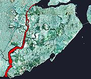
The channelChannel (geography)
In physical geography, a channel is the physical confine of a river, slough or ocean strait consisting of a bed and banks.A channel is also the natural or human-made deeper course through a reef, sand bar, bay, or any shallow body of water...
is approximately 10 miles (16 km) long and connects Raritan Bay
Raritan Bay
Raritan Bay is a bay located at the southern portion of Lower New York Bay between the U.S. states of New York and New Jersey and is part of the New York Bight. The bay is bounded on the northwest by New York's Staten Island, on the west by Perth Amboy, New Jersey, on the south by the Raritan...
on its south end with Newark Bay
Newark Bay
Newark Bay is a tidal bay at the confluence of the Passaic and Hackensack Rivers in northeastern New Jersey. It is home to the Port Newark-Elizabeth Marine Terminal, the largest container shipping facility in Port of New York and New Jersey, 3rd largest and one of busiest in the United States...
on the north. Along the New Jersey
New Jersey
New Jersey is a state in the Northeastern and Middle Atlantic regions of the United States. , its population was 8,791,894. It is bordered on the north and east by the state of New York, on the southeast and south by the Atlantic Ocean, on the west by Pennsylvania and on the southwest by Delaware...
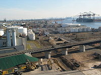
side it is primarily lined with industrial sites, part of which is called the Chemical Coast
Chemical Coast
The Chemical Coast is the section of Union and Middlesex counties in New Jersey. It is located along the shores of the Arthur Kill, a heavily used waterway of the Port of New York and New Jersey, across from Staten Island, New York.-History:...
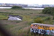
. The Staten Island side, it is primarily lined with salt marsh
Salt marsh
A salt marsh is an environment in the upper coastal intertidal zone between land and salt water or brackish water, it is dominated by dense stands of halophytic plants such as herbs, grasses, or low shrubs. These plants are terrestrial in origin and are essential to the stability of the salt marsh...
es.
A heavily used marine channel, it provides access for ocean-going container ship
Container ship
Container ships are cargo ships that carry all of their load in truck-size intermodal containers, in a technique called containerization. They form a common means of commercial intermodal freight transport.-History:...
s to Port Newark and to industrial facilities along the channel itself. It also provides the primary marine access to the now-closed Fresh Kills Landfill
Fresh Kills Landfill
The Fresh Kills Landfill was a landfill covering in the New York City borough of Staten Island in the United States. The name comes from the landfill's location along the banks of the Fresh Kills estuary in western Staten Island...
on Staten Island.
The channel is dredged periodically to a depth of 35–37 feet (11 m) and a width of 600 feet (183 m) to maintain its usefulness for commercial ship passage.
Because of the complex nature of the tides in New York-New Jersey Harbor Estuary near the mouth of the Hudson River
Hudson River
The Hudson is a river that flows from north to south through eastern New York. The highest official source is at Lake Tear of the Clouds, on the slopes of Mount Marcy in the Adirondack Mountains. The river itself officially begins in Henderson Lake in Newcomb, New York...
, the hydrology
Hydrology
Hydrology is the study of the movement, distribution, and quality of water on Earth and other planets, including the hydrologic cycle, water resources and environmental watershed sustainability...
of the Arthur Kill is still an open subject. In particular, the net flow of the channel is not well established.
It is spanned by the Goethals Bridge
Goethals Bridge
The Goethals Bridge connects Elizabeth, New Jersey to Staten Island , near the Howland Hook Marine Terminal, Staten Island, New York over the Arthur Kill. Operated by the Port Authority of New York and New Jersey, the span was one of the first structures built by the authority...
and the Outerbridge Crossing
Outerbridge Crossing
The Outerbridge Crossing is a cantilever bridge which spans the Arthur Kill. The "Outerbridge", as it is commonly known, connects Perth Amboy, New Jersey, with the New York City borough of Staten Island and carries NY-440 and NJ-440, each road ending at the respective state border.The bridge was...
, as well as by the Arthur Kill Vertical Lift Bridge
Arthur Kill Vertical Lift Bridge
The Arthur Kill Vertical Lift Railroad Bridge is a railroad-only, vertical lift bridge connecting Elizabethport, New Jersey and the Howland Hook Marine Terminal on Staten Island. The bridge was built by the Baltimore and Ohio Railroad in 1959 to replace an older swing span...
, a railroad bridge and the largest bridge of its type in the United States.
It contains two small uninhabited islands, Prall's Island
Prall's Island
Prall's Island is an uninhabited island in the Arthur Kill between Staten Island, New York, and Linden, New Jersey, in the United States. It is one of the minor islands that are part of the borough of Staten Island in New York City...
and the Isle of Meadows, both of which belong to the borough
Borough (New York City)
New York City, one of the largest cities in the world, is composed of five boroughs. Each borough now has the same boundaries as the county it is in. County governments were dissolved when the city consolidated in 1898, along with all city, town, and village governments within each county...
of Staten Island.
Geology
The Arthur Kill is an abandoned river channel carved by an ancestral phase of the Hudson River resulting from the blockage of the main channel of the Hudson at the NarrowsThe Narrows
The Narrows is the tidal strait separating the boroughs of Staten Island and Brooklyn in New York City. It connects the Upper New York Bay and Lower New York Bay and forms the principal channel by which the Hudson River empties into the Atlantic Ocean...
by moraine
Moraine
A moraine is any glacially formed accumulation of unconsolidated glacial debris which can occur in currently glaciated and formerly glaciated regions, such as those areas acted upon by a past glacial maximum. This debris may have been plucked off a valley floor as a glacier advanced or it may have...
or an ice dam
Ice dam
An ice dam occurs when water builds up behind a blockage of ice. Ice dams can occur in various ways.-Caused by a glacier:Sometimes a glacier flows down a valley to a confluence where the other branch carries an unfrozen river...
. The size of the Arthur Kill channel is large, suggesting that it was, for a time, the primary drainage from the region. However, it could not have been a primary drainage for long because the river did not have enough time to carve a broad flood plain.
Etymology
The name Arthur Kill is an anglicisationAnglicisation
Anglicisation, or anglicization , is the process of converting verbal or written elements of any other language into a form that is more comprehensible to an English speaker, or, more generally, of altering something such that it becomes English in form or character.The term most often refers to...
of the Dutch language
Dutch language
Dutch is a West Germanic language and the native language of the majority of the population of the Netherlands, Belgium, and Suriname, the three member states of the Dutch Language Union. Most speakers live in the European Union, where it is a first language for about 23 million and a second...
achter kill meaning back channel, which would refer to its location "behind" Staten Island and has its roots in the early 17th century during the Dutch colonial
Netherlands
The Netherlands is a constituent country of the Kingdom of the Netherlands, located mainly in North-West Europe and with several islands in the Caribbean. Mainland Netherlands borders the North Sea to the north and west, Belgium to the south, and Germany to the east, and shares maritime borders...
era when the region was part of New Netherland
New Netherland
New Netherland, or Nieuw-Nederland in Dutch, was the 17th-century colonial province of the Republic of the Seven United Netherlands on the East Coast of North America. The claimed territories were the lands from the Delmarva Peninsula to extreme southwestern Cape Cod...
. Placenaming by early explorers and settlers during the era often referred to a location in reference to other places, its shape, its topography, and other geographic qualities. Kill
Kill (body of water)
As a body of water, a kill is a creek. The word comes from the Middle Dutch kille, meaning "riverbed" or "water channel." The modern Dutch term is kil....
comes from the Middle Dutch
Dutch language
Dutch is a West Germanic language and the native language of the majority of the population of the Netherlands, Belgium, and Suriname, the three member states of the Dutch Language Union. Most speakers live in the European Union, where it is a first language for about 23 million and a second...
word kille
Kill (body of water)
As a body of water, a kill is a creek. The word comes from the Middle Dutch kille, meaning "riverbed" or "water channel." The modern Dutch term is kil....
, meaning riverbed, water channel, or stream. The area around the Newark Bay was called Achter Kol. During the British colonial era the bay was known as Cull bay. The bay lies behind Bergen Hill
Bergen Hill
Bergen Hill refers to the lower Hudson Palisades in New Jersey, USA, where they emerge on Bergen Neck, which in turn is the peninsula between the Hackensack and Hudson River, and their bays. In Hudson County, it reaches a height of 260 feet.-Rail:...
, the emerging ridge of the Hudson Palisades which begins on Bergen Neck
Bergen Neck
Bergen Neck is a name for the peninsula between the Upper New York Bay and the Newark Bay in the Hudson County, New Jersey municipalities of Bayonne and Jersey City...
, the peninsula between it and the Upper New York Bay
Upper New York Bay
Upper New York Bay, or Upper Bay, is the traditional heart of the Port of New York and New Jersey, and often called New York Harbor. It is enclosed by the New York City boroughs of Manhattan, Brooklyn, and Staten Island and the Hudson County, New Jersey municipalities of Jersey City and Bayonne.It...
. The sister channel of Arthur Kill, Kill van Kull
Kill Van Kull
The Kill Van Kull is a tidal strait between Staten Island, New York and Bayonne, New Jersey in the United States. Approximately long and wide, it connects Newark Bay with Upper New York Bay. The Robbins Reef Light marks the eastern end of the Kill, Bergen Point its western end...
refers to the waterway that flows from the col or ridge or passage
Mountain pass
A mountain pass is a route through a mountain range or over a ridge. If following the lowest possible route, a pass is locally the highest point on that route...
to the interior and translates as channel from the pass or ridge.
Tributaries
- Elizabeth RiverElizabeth River (New Jersey)The Elizabeth River is a tributary of the Arthur Kill in Union County, New Jersey in the United States.The Elizabeth River begins at the border between the Union and Essex counties near exit 142/142 A on the Garden State Parkway in Hillside, and near Beech Spring Road...
- Rahway RiverRahway RiverThe Rahway River is a river, approximately 24 mi long, in northeastern New Jersey in the United States. The river drains part of the suburban and urbanized area of New Jersey west of New York City. Part of the extended area of New York Harbor, the river empties into the Arthur Kill. In its...
- Passaic RiverPassaic RiverThe Passaic River is a mature surface river, approximately 80 mi long, in northern New Jersey in the United States. The river in its upper course flows in a highly circuitous route, meandering through the swamp lowlands between the ridge hills of rural and suburban northern New Jersey,...
- Hackensack RiverHackensack RiverThe Hackensack River is a river, approximately 45 miles long, in the U.S. states of New York and New Jersey, emptying into Newark Bay, a back chamber of New York Harbor. The watershed of the river includes part of the suburban area outside New York City just west of the lower Hudson River,...
See also
- Chemical CoastChemical CoastThe Chemical Coast is the section of Union and Middlesex counties in New Jersey. It is located along the shores of the Arthur Kill, a heavily used waterway of the Port of New York and New Jersey, across from Staten Island, New York.-History:...
- Achter Col, New NetherlandAchter Col, New NetherlandAchter Kol was the name given to the region around the Newark Bay and Hackensack River in northeastern New Jersey by the first European settlers to it and was part of the seventeenth century province of New Netherland, originally administered by the Dutch West India Company...
and Toponymy of New NetherlandToponymy of New NetherlandNieuw-Nederland, or New Netherland, was the seventeenth century colonial province of the Republic of the Seven United Netherlands on northeastern coast of North America. The claimed territory were the lands from the Delmarva Peninsula to southern Cape Cod. Settled areas are now part of the... - List of New Jersey rivers
- Lower New York BayLower New York BayLower New York Bay is that section of New York Bay south of the Narrows, the relatively narrow strait between the shores of Staten Island and Brooklyn. The southern end of the bay opens directly to the Atlantic Ocean between two spits of land, Sandy Hook, New Jersey, and Rockaway, Queens, on Long...
- Raritan BayRaritan BayRaritan Bay is a bay located at the southern portion of Lower New York Bay between the U.S. states of New York and New Jersey and is part of the New York Bight. The bay is bounded on the northwest by New York's Staten Island, on the west by Perth Amboy, New Jersey, on the south by the Raritan...
- Hudson CanyonHudson Canyon__notoc__The Hudson Canyon is a submarine canyon that begins from the shallow outlet of the estuary at the mouth of the Hudson River. It extends out over seaward across the continental shelf finally connecting to the deep ocean basin at a depth of 3 to 4 km below sea level...
- Geography of New York-New Jersey Harbor Estuary
- Perth Amboy Ferry SlipPerth Amboy Ferry SlipThe Perth Amboy Ferry Slip, located on Arthur Kill in Perth Amboy, New Jersey, was once a vital ferry slip for boats in New York Harbor.It was added to the New Jersey Register of Historic Places and National Register of Historic Places in 1978. The ferry slip was restored in 1998 to its 1904...

