
.gif)
Hurricane Lester (1992)
Encyclopedia
Hurricane Lester was the first Pacific tropical cyclone
to enter the United States
as a tropical storm since 1967. The twelfth named storm and seventh hurricane of the 1992 Pacific hurricane season
, Lester formed on August 20 from a tropical wave
southwest of Mexico
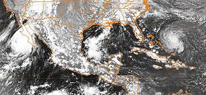
. The tropical storm moved generally northwestward while steadily intensifying. After turning to the north, approaching the Mexican coast, Lester attained hurricane status. The hurricane reached peak winds of 85 mph (140 km/h) before making landfall on west-central Baja California
. The system weakened while moving across the peninsula and then over northwestern Mexico. Not long after entering Arizona
, Lester weakened to a tropical depression, and dissipated on August 24 over New Mexico
.
In Mexico, the hurricane resulted in $3 million in damage (1992 USD, $4.7 million 2011 USD). It also left 5,000 people left homeless, and was responsible for three fatalities. The remnants of Lester also produced moderate rainfall and minor flooding across southern California
, Colorado
, Arizona and New Mexico, as well as rare August snow in the Rocky Mountains
.
moved off the coast of Africa
on August 7. It tracked across the Atlantic Ocean
and Caribbean Sea
without development due to strong wind shear
. The wave then split into two, with the northern portion dissipating over Cuba
on August 15 and the southern portion continuing westward. The wave crossed Central America
and entered the Pacific Ocean
on August 16. Deep convection increased over the wave upon entering the Pacific, and early on August 19 it started to become better organized. After the development of a low-level circulation, the system organized into Tropical Depression Fourteen-E on August 20 while located about 275 miles (445 km) south-southwest of Manzanillo, Colima
.
The depression gradually tracked northwestward at 15 mph (24 km/h). Although the center of the depression was initially uncertain, it slowly strengthened and steadily organized. The depression attained tropical storm status late on August 20, upon which the storm was named Lester
. The cyclone continued to the northwest, and passed directly over Socorro Island
on August 21. By early the next day, an eastward moving trough
weakened the ridge
to its north, resulting in a to turn to the north. Around this time, forecasters at the National Hurricane Center
predicted the storm would not strengthen to hurricane intensity before making landfall. Despite this, Lester intensified into a hurricane late on August 22 while located about 240 miles (385 km) west of La Paz
in Baja California Sur
.
 The hurricane continued to organize and banding-type eye
soon formed. Early on August 23 it attained peak winds of 85 mph (140 km/h) with a minimum central pressure of 985 mbar
(hPa; 29.09 inHg). Lester weakened steadily as the storm turned to the northeast, and made landfall as a minimal hurricane near Punta Abreojos, Baja California Sur
about ten hours after reaching peak intensity. It degenerated into a tropical storm while crossing the Baja California Peninsula
. After passing through the northern Gulf of California
, it made a second landfall near Isla Tiburon in the state of Sonora
. Lester entered Arizona
as a tropical storm on August 24, the first time since Hurricane Katrina in 1967
that an Eastern Pacific tropical cyclone
entered the United States
with winds of at least tropical storm intensity. Lester maintained tropical storm status until it weakened into a tropical depression near Tucson, Arizona
. Later that day, the low level circulation dissipated over New Mexico
, and Lester ceased to exist as a tropical cyclone. The storms remnants transitioned into an extratropical cyclone
as it continued to the north-northeast ahead of an approaching trough
, and merged with the remnants of Hurricane Andrew
on August 29 over Pennsylvania
.
for Baja California
on August 21. The following day, a hurricane warning was issued for the peninsula from Punta Eugenia
southward to Cabo San Lazaro
. The government of Mexico also issued a tropical storm warning for the Sonora
and Sinaloa
mainland from Cabo Tepopa
to Los Mochis
. All watches and warnings were discontinued as the storm weakened and dissipated. The threat of the hurricane prompted the evacuation of about 10,000 residents.
No observations exist for the duration when Lester, as a tropical depression, moved over Socorro Island
, while winds were estimated to have reached 37 mph (59 km/h). However, a station reported winds of 23 mph (37 km/h) six hours after Lester passed over Socorro Island. Several ships came in contact with Lester, with one in the eye
reporting hurricane force winds for 11 hours on August 22. The ship in the eye reported rough seas, causing it to roll 33° to each side and thus was responsible for a large amount of cargo to go overboard.
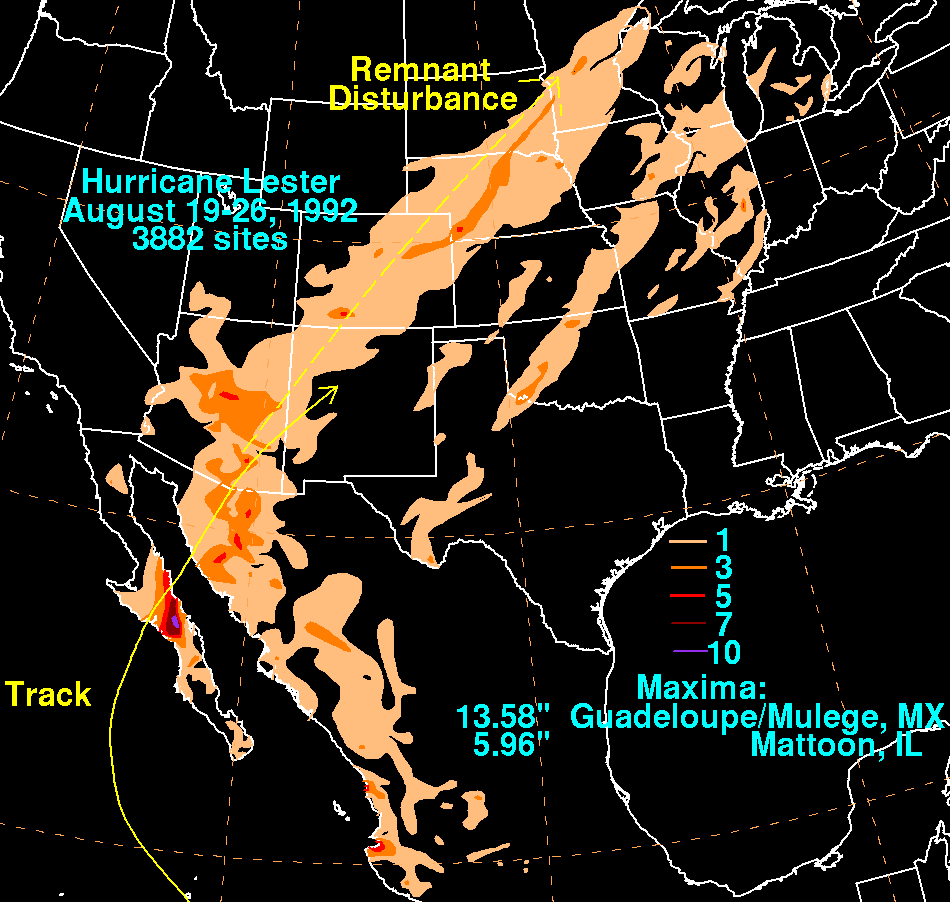
Hurricane Lester produced heavy rainfall across its path through the Baja California Peninsula
and Sonora
. Peak rainfall occurred in Mulege
with 13.58 in (344.9 mm). A weather station in Presa Rodriquez reported 8.66 inches (203 mm) of precipitation, with several other locations reporting over 2 inches (50 mm). The heavy rainfall caused extensive flood damage to the west of Hermosillo
, destroying some entire communities and flooding a large highway. Roads were washed out, and power lines were knocked out. Waves up to 20 ft (6.1 m) were recorded. Flash flooding from Lester caused 10,000 people to be evacuated from their homes. In addition, mudslides killed three people, and left 5,000 homeless. The storm resulted in $3 million (1992 USD
), equivalent to $4.7 million (2011 USD). The Mexican Army
provided relief efforts to residents after the storm.
. In Arizona
, rainfall amounted to over 5 inches (125 mm) near Phoenix
and Tucson
, with much of the rest of the state reporting over 1 inch (25 mm). Moderate rainfall was also reported in western New Mexico
and southern Utah
, while one location in southwestern Colorado
reported over 5 inches (125 mm) of precipitation. The rainfall caused moderate flooding in Denver. In addition to the rainfall, moisture from the remnants of Lester dropped 2 to 4 inches (50 to 100 mm) of snow across portions of Colorado, causing traffic problems in mountainous areas. A weather station on Mt. Harvard recorded about 4 inches (100 mm) of snow during Lester's passage through Colorado. Moisture enhanced from a cold front, the remnants Lester extended through the eastern United States
, with Mattoon, Illinois
reporting a peak of 5.96 inches (151 mm). In all, rain from Lester caused rainfall records in Minnesota
, Nebraska
, Colorado, and North Dakota
.
Pacific hurricane
A Pacific hurricane or tropical storm is a tropical cyclone that develops in the northeastern part of the Pacific Ocean. For organizational purposes, the northern Pacific Ocean is divided into three regions: the eastern, , central , and western...
to enter the United States
United States
The United States of America is a federal constitutional republic comprising fifty states and a federal district...
as a tropical storm since 1967. The twelfth named storm and seventh hurricane of the 1992 Pacific hurricane season
1992 Pacific hurricane season
The 1992 Pacific hurricane season was the most active Pacific hurricane season on record. The most notable storm was Hurricane Iniki, which caused billions of dollars of damage to the Hawaiian Islands. Hurricanes Lester, Virgil, Winifred, and Orlene also made landfall and killed several people, but...
, Lester formed on August 20 from a tropical wave
Tropical wave
Tropical waves, easterly waves, or tropical easterly waves, also known as African easterly waves in the Atlantic region, are a type of atmospheric trough, an elongated area of relatively low air pressure, oriented north to south, which move from east to west across the tropics causing areas of...
southwest of Mexico
Mexico
The United Mexican States , commonly known as Mexico , is a federal constitutional republic in North America. It is bordered on the north by the United States; on the south and west by the Pacific Ocean; on the southeast by Guatemala, Belize, and the Caribbean Sea; and on the east by the Gulf of...
. The tropical storm moved generally northwestward while steadily intensifying. After turning to the north, approaching the Mexican coast, Lester attained hurricane status. The hurricane reached peak winds of 85 mph (140 km/h) before making landfall on west-central Baja California
Baja California Peninsula
The Baja California peninsula , is a peninsula in northwestern Mexico. Its land mass separates the Pacific Ocean from the Gulf of California. The Peninsula extends from Mexicali, Baja California in the north to Cabo San Lucas, Baja California Sur in the south.The total area of the Baja California...
. The system weakened while moving across the peninsula and then over northwestern Mexico. Not long after entering Arizona
Arizona
Arizona ; is a state located in the southwestern region of the United States. It is also part of the western United States and the mountain west. The capital and largest city is Phoenix...
, Lester weakened to a tropical depression, and dissipated on August 24 over New Mexico
New Mexico
New Mexico is a state located in the southwest and western regions of the United States. New Mexico is also usually considered one of the Mountain States. With a population density of 16 per square mile, New Mexico is the sixth-most sparsely inhabited U.S...
.
In Mexico, the hurricane resulted in $3 million in damage (1992 USD, $4.7 million 2011 USD). It also left 5,000 people left homeless, and was responsible for three fatalities. The remnants of Lester also produced moderate rainfall and minor flooding across southern California
California
California is a state located on the West Coast of the United States. It is by far the most populous U.S. state, and the third-largest by land area...
, Colorado
Colorado
Colorado is a U.S. state that encompasses much of the Rocky Mountains as well as the northeastern portion of the Colorado Plateau and the western edge of the Great Plains...
, Arizona and New Mexico, as well as rare August snow in the Rocky Mountains
Rocky Mountains
The Rocky Mountains are a major mountain range in western North America. The Rocky Mountains stretch more than from the northernmost part of British Columbia, in western Canada, to New Mexico, in the southwestern United States...
.
Meteorological history
A weak tropical waveTropical wave
Tropical waves, easterly waves, or tropical easterly waves, also known as African easterly waves in the Atlantic region, are a type of atmospheric trough, an elongated area of relatively low air pressure, oriented north to south, which move from east to west across the tropics causing areas of...
moved off the coast of Africa
Africa
Africa is the world's second largest and second most populous continent, after Asia. At about 30.2 million km² including adjacent islands, it covers 6% of the Earth's total surface area and 20.4% of the total land area...
on August 7. It tracked across the Atlantic Ocean
Atlantic Ocean
The Atlantic Ocean is the second-largest of the world's oceanic divisions. With a total area of about , it covers approximately 20% of the Earth's surface and about 26% of its water surface area...
and Caribbean Sea
Caribbean Sea
The Caribbean Sea is a sea of the Atlantic Ocean located in the tropics of the Western hemisphere. It is bounded by Mexico and Central America to the west and southwest, to the north by the Greater Antilles, and to the east by the Lesser Antilles....
without development due to strong wind shear
Wind shear
Wind shear, sometimes referred to as windshear or wind gradient, is a difference in wind speed and direction over a relatively short distance in the atmosphere...
. The wave then split into two, with the northern portion dissipating over Cuba
Cuba
The Republic of Cuba is an island nation in the Caribbean. The nation of Cuba consists of the main island of Cuba, the Isla de la Juventud, and several archipelagos. Havana is the largest city in Cuba and the country's capital. Santiago de Cuba is the second largest city...
on August 15 and the southern portion continuing westward. The wave crossed Central America
Central America
Central America is the central geographic region of the Americas. It is the southernmost, isthmian portion of the North American continent, which connects with South America on the southeast. When considered part of the unified continental model, it is considered a subcontinent...
and entered the Pacific Ocean
Pacific Ocean
The Pacific Ocean is the largest of the Earth's oceanic divisions. It extends from the Arctic in the north to the Southern Ocean in the south, bounded by Asia and Australia in the west, and the Americas in the east.At 165.2 million square kilometres in area, this largest division of the World...
on August 16. Deep convection increased over the wave upon entering the Pacific, and early on August 19 it started to become better organized. After the development of a low-level circulation, the system organized into Tropical Depression Fourteen-E on August 20 while located about 275 miles (445 km) south-southwest of Manzanillo, Colima
Manzanillo, Colima
The name Manzanillo refers to the city as well as its surrounding municipality in the Mexican state of Colima. The city, located on the Pacific Ocean, contains Mexico's busiest port. Manzanillo was the third port created by the Spanish in the Pacific during the New Spain period...
.
The depression gradually tracked northwestward at 15 mph (24 km/h). Although the center of the depression was initially uncertain, it slowly strengthened and steadily organized. The depression attained tropical storm status late on August 20, upon which the storm was named Lester
Lester
Lester is a Scottish and Irish surname of Gaelic origin, which is a variant of the surname Lister.Lester may refer to:-Given name:*Lester Bangs , American music critic...
. The cyclone continued to the northwest, and passed directly over Socorro Island
Socorro Island
Socorro Island is a small volcanic island in the Revillagigedo Islands, a Mexican possession lying some 600 kilometers off the country's western coast at 18°48'N, 110°59'W. The size is 16.5 by 11.5 km, with an area of 132 km².- Geology :...
on August 21. By early the next day, an eastward moving trough
Trough (meteorology)
A trough is an elongated region of relatively low atmospheric pressure, often associated with fronts.Unlike fronts, there is not a universal symbol for a trough on a weather chart. The weather charts in some countries or regions mark troughs by a line. In the United States, a trough may be marked...
weakened the ridge
Ridge (meteorology)
A ridge is an elongated region of relatively high atmospheric pressure, the opposite of a trough....
to its north, resulting in a to turn to the north. Around this time, forecasters at the National Hurricane Center
National Hurricane Center
The National Hurricane Center , located at Florida International University in Miami, Florida, is the division of the National Weather Service responsible for tracking and predicting weather systems within the tropics between the Prime Meridian and the 140th meridian west poleward to the 30th...
predicted the storm would not strengthen to hurricane intensity before making landfall. Despite this, Lester intensified into a hurricane late on August 22 while located about 240 miles (385 km) west of La Paz
La Paz, Baja California Sur
La Paz is the capital city of the Mexican state of Baja California Sur and an important regional commercial center. The city had a 2010 census population of 215,178 persons, but its metropolitan population is somewhat larger because of surrounding towns like el Centenario, el Zacatal and San Pedro...
in Baja California Sur
Baja California Sur
Baja California Sur , is one of the 31 states which, with the Federal District, comprise the 32 Federal Entities of Mexico. Before becoming a state on October 8, 1974, the area was known as the South Territory of Baja California. It has an area of , or 3.57% of the land mass of Mexico and comprises...
.
Eye (cyclone)
The eye is a region of mostly calm weather found at the center of strong tropical cyclones. The eye of a storm is a roughly circular area and typically 30–65 km in diameter. It is surrounded by the eyewall, a ring of towering thunderstorms where the second most severe weather of a cyclone...
soon formed. Early on August 23 it attained peak winds of 85 mph (140 km/h) with a minimum central pressure of 985 mbar
Bar (unit)
The bar is a unit of pressure equal to 100 kilopascals, and roughly equal to the atmospheric pressure on Earth at sea level. Other units derived from the bar are the megabar , kilobar , decibar , centibar , and millibar...
(hPa; 29.09 inHg). Lester weakened steadily as the storm turned to the northeast, and made landfall as a minimal hurricane near Punta Abreojos, Baja California Sur
Mulegé (municipality)
Mulegé is the northernmost municipality of the Mexican state of Baja California Sur. It is the second-largest municipality by area in the country, with an area of 32,092.2 km² . In the census of 2010 it had a population of 59,114 inhabitants...
about ten hours after reaching peak intensity. It degenerated into a tropical storm while crossing the Baja California Peninsula
Baja California Peninsula
The Baja California peninsula , is a peninsula in northwestern Mexico. Its land mass separates the Pacific Ocean from the Gulf of California. The Peninsula extends from Mexicali, Baja California in the north to Cabo San Lucas, Baja California Sur in the south.The total area of the Baja California...
. After passing through the northern Gulf of California
Gulf of California
The Gulf of California is a body of water that separates the Baja California Peninsula from the Mexican mainland...
, it made a second landfall near Isla Tiburon in the state of Sonora
Sonora
Sonora officially Estado Libre y Soberano de Sonora is one of the 31 states which, with the Federal District, comprise the 32 Federal Entities of Mexico. It is divided into 72 municipalities; the capital city is Hermosillo....
. Lester entered Arizona
Arizona
Arizona ; is a state located in the southwestern region of the United States. It is also part of the western United States and the mountain west. The capital and largest city is Phoenix...
as a tropical storm on August 24, the first time since Hurricane Katrina in 1967
1967 Pacific hurricane season
The 1967 Pacific hurricane season started on June 1 and ended on November 30, 1967. The season was of little note except for Hurricanes Katrina and Olivia. Katrina made landfall on the Baja Peninsula, killing at least 60 and make 2,500 homeless. Olivia made landfall on the Eastern side of the Baja...
that an Eastern Pacific tropical cyclone
Pacific hurricane
A Pacific hurricane or tropical storm is a tropical cyclone that develops in the northeastern part of the Pacific Ocean. For organizational purposes, the northern Pacific Ocean is divided into three regions: the eastern, , central , and western...
entered the United States
United States
The United States of America is a federal constitutional republic comprising fifty states and a federal district...
with winds of at least tropical storm intensity. Lester maintained tropical storm status until it weakened into a tropical depression near Tucson, Arizona
Tucson, Arizona
Tucson is a city in and the county seat of Pima County, Arizona, United States. The city is located 118 miles southeast of Phoenix and 60 miles north of the U.S.-Mexico border. The 2010 United States Census puts the city's population at 520,116 with a metropolitan area population at 1,020,200...
. Later that day, the low level circulation dissipated over New Mexico
New Mexico
New Mexico is a state located in the southwest and western regions of the United States. New Mexico is also usually considered one of the Mountain States. With a population density of 16 per square mile, New Mexico is the sixth-most sparsely inhabited U.S...
, and Lester ceased to exist as a tropical cyclone. The storms remnants transitioned into an extratropical cyclone
Extratropical cyclone
Extratropical cyclones, sometimes called mid-latitude cyclones or wave cyclones, are a group of cyclones defined as synoptic scale low pressure weather systems that occur in the middle latitudes of the Earth having neither tropical nor polar characteristics, and are connected with fronts and...
as it continued to the north-northeast ahead of an approaching trough
Trough (meteorology)
A trough is an elongated region of relatively low atmospheric pressure, often associated with fronts.Unlike fronts, there is not a universal symbol for a trough on a weather chart. The weather charts in some countries or regions mark troughs by a line. In the United States, a trough may be marked...
, and merged with the remnants of Hurricane Andrew
Hurricane Andrew
Hurricane Andrew was the third Category 5 hurricane to make landfall in the United States, after the Labor Day Hurricane of 1935 and Hurricane Camille in 1969. Andrew was the first named storm and only major hurricane of the otherwise inactive 1992 Atlantic hurricane season...
on August 29 over Pennsylvania
Pennsylvania
The Commonwealth of Pennsylvania is a U.S. state that is located in the Northeastern and Mid-Atlantic regions of the United States. The state borders Delaware and Maryland to the south, West Virginia to the southwest, Ohio to the west, New York and Ontario, Canada, to the north, and New Jersey to...
.
Preparations and Impact
Mexico
The Government of Mexico issued tropical storm watches and warningsTropical cyclone warnings and watches
Warnings and watches are two levels of alert issued by national weather forecasting bodies to coastal areas threatened by the imminent approach of a tropical cyclone of tropical storm or hurricane intensity. They are notices to the local population and civil authorities to make appropriate...
for Baja California
Baja California
Baja California officially Estado Libre y Soberano de Baja California is one of the 31 states which, with the Federal District, comprise the 32 Federal Entities of Mexico. It is both the northernmost and westernmost state of Mexico. Before becoming a state in 1953, the area was known as the North...
on August 21. The following day, a hurricane warning was issued for the peninsula from Punta Eugenia
Mulegé (municipality)
Mulegé is the northernmost municipality of the Mexican state of Baja California Sur. It is the second-largest municipality by area in the country, with an area of 32,092.2 km² . In the census of 2010 it had a population of 59,114 inhabitants...
southward to Cabo San Lazaro
Baja California Sur
Baja California Sur , is one of the 31 states which, with the Federal District, comprise the 32 Federal Entities of Mexico. Before becoming a state on October 8, 1974, the area was known as the South Territory of Baja California. It has an area of , or 3.57% of the land mass of Mexico and comprises...
. The government of Mexico also issued a tropical storm warning for the Sonora
Sonora
Sonora officially Estado Libre y Soberano de Sonora is one of the 31 states which, with the Federal District, comprise the 32 Federal Entities of Mexico. It is divided into 72 municipalities; the capital city is Hermosillo....
and Sinaloa
Sinaloa
Sinaloa officially Estado Libre y Soberano de Sinaloa is one of the 31 states which, with the Federal District, comprise the 32 Federal Entities of Mexico. It is divided in 18 municipalities and its capital city is Culiacán Rosales....
mainland from Cabo Tepopa
Sonora
Sonora officially Estado Libre y Soberano de Sonora is one of the 31 states which, with the Federal District, comprise the 32 Federal Entities of Mexico. It is divided into 72 municipalities; the capital city is Hermosillo....
to Los Mochis
Los Mochis
Los Mochis is a coastal city in northern Sinaloa, Mexico. It serves as the municipal seat of the municipality of Ahome. As of the 2010 census, the population was 256,613, which was 61 percent of the municipality's population....
. All watches and warnings were discontinued as the storm weakened and dissipated. The threat of the hurricane prompted the evacuation of about 10,000 residents.
No observations exist for the duration when Lester, as a tropical depression, moved over Socorro Island
Socorro Island
Socorro Island is a small volcanic island in the Revillagigedo Islands, a Mexican possession lying some 600 kilometers off the country's western coast at 18°48'N, 110°59'W. The size is 16.5 by 11.5 km, with an area of 132 km².- Geology :...
, while winds were estimated to have reached 37 mph (59 km/h). However, a station reported winds of 23 mph (37 km/h) six hours after Lester passed over Socorro Island. Several ships came in contact with Lester, with one in the eye
Eye (cyclone)
The eye is a region of mostly calm weather found at the center of strong tropical cyclones. The eye of a storm is a roughly circular area and typically 30–65 km in diameter. It is surrounded by the eyewall, a ring of towering thunderstorms where the second most severe weather of a cyclone...
reporting hurricane force winds for 11 hours on August 22. The ship in the eye reported rough seas, causing it to roll 33° to each side and thus was responsible for a large amount of cargo to go overboard.
Hurricane Lester produced heavy rainfall across its path through the Baja California Peninsula
Baja California Peninsula
The Baja California peninsula , is a peninsula in northwestern Mexico. Its land mass separates the Pacific Ocean from the Gulf of California. The Peninsula extends from Mexicali, Baja California in the north to Cabo San Lucas, Baja California Sur in the south.The total area of the Baja California...
and Sonora
Sonora
Sonora officially Estado Libre y Soberano de Sonora is one of the 31 states which, with the Federal District, comprise the 32 Federal Entities of Mexico. It is divided into 72 municipalities; the capital city is Hermosillo....
. Peak rainfall occurred in Mulege
Mulegé
Mulegé is an oasis town in the Mexican state of Baja California Sur, situated at the mouth of the Río de Santa Rosalía. It is the fourth-largest community in Mulegé Municipality...
with 13.58 in (344.9 mm). A weather station in Presa Rodriquez reported 8.66 inches (203 mm) of precipitation, with several other locations reporting over 2 inches (50 mm). The heavy rainfall caused extensive flood damage to the west of Hermosillo
Hermosillo
Hermosillo is a city and municipality located centrally in the northwestern Mexican state of Sonora. It is the capital and main economic center for the state and region. It contains almost all of the state's manufacturing and has thirty percent of its population...
, destroying some entire communities and flooding a large highway. Roads were washed out, and power lines were knocked out. Waves up to 20 ft (6.1 m) were recorded. Flash flooding from Lester caused 10,000 people to be evacuated from their homes. In addition, mudslides killed three people, and left 5,000 homeless. The storm resulted in $3 million (1992 USD
United States dollar
The United States dollar , also referred to as the American dollar, is the official currency of the United States of America. It is divided into 100 smaller units called cents or pennies....
), equivalent to $4.7 million (2011 USD). The Mexican Army
Mexico
The United Mexican States , commonly known as Mexico , is a federal constitutional republic in North America. It is bordered on the north by the United States; on the south and west by the Pacific Ocean; on the southeast by Guatemala, Belize, and the Caribbean Sea; and on the east by the Gulf of...
provided relief efforts to residents after the storm.
United States
The remnants of Lester produced heavy rainfall across the Southwestern United StatesSouthwestern United States
The Southwestern United States is a region defined in different ways by different sources. Broad definitions include nearly a quarter of the United States, including Arizona, California, Colorado, Nevada, New Mexico, Oklahoma, Texas and Utah...
. In Arizona
Arizona
Arizona ; is a state located in the southwestern region of the United States. It is also part of the western United States and the mountain west. The capital and largest city is Phoenix...
, rainfall amounted to over 5 inches (125 mm) near Phoenix
Phoenix, Arizona
Phoenix is the capital, and largest city, of the U.S. state of Arizona, as well as the sixth most populated city in the United States. Phoenix is home to 1,445,632 people according to the official 2010 U.S. Census Bureau data...
and Tucson
Tucson, Arizona
Tucson is a city in and the county seat of Pima County, Arizona, United States. The city is located 118 miles southeast of Phoenix and 60 miles north of the U.S.-Mexico border. The 2010 United States Census puts the city's population at 520,116 with a metropolitan area population at 1,020,200...
, with much of the rest of the state reporting over 1 inch (25 mm). Moderate rainfall was also reported in western New Mexico
New Mexico
New Mexico is a state located in the southwest and western regions of the United States. New Mexico is also usually considered one of the Mountain States. With a population density of 16 per square mile, New Mexico is the sixth-most sparsely inhabited U.S...
and southern Utah
Utah
Utah is a state in the Western United States. It was the 45th state to join the Union, on January 4, 1896. Approximately 80% of Utah's 2,763,885 people live along the Wasatch Front, centering on Salt Lake City. This leaves vast expanses of the state nearly uninhabited, making the population the...
, while one location in southwestern Colorado
Colorado
Colorado is a U.S. state that encompasses much of the Rocky Mountains as well as the northeastern portion of the Colorado Plateau and the western edge of the Great Plains...
reported over 5 inches (125 mm) of precipitation. The rainfall caused moderate flooding in Denver. In addition to the rainfall, moisture from the remnants of Lester dropped 2 to 4 inches (50 to 100 mm) of snow across portions of Colorado, causing traffic problems in mountainous areas. A weather station on Mt. Harvard recorded about 4 inches (100 mm) of snow during Lester's passage through Colorado. Moisture enhanced from a cold front, the remnants Lester extended through the eastern United States
United States
The United States of America is a federal constitutional republic comprising fifty states and a federal district...
, with Mattoon, Illinois
Mattoon, Illinois
Mattoon is a city in Coles County, Illinois, United States. The population was 18,555 as of the 2010 census. It is a principal city of the Charleston–Mattoon Micropolitan Statistical Area.Mattoon was the site of the "Mad Gasser" attacks of the 1940s....
reporting a peak of 5.96 inches (151 mm). In all, rain from Lester caused rainfall records in Minnesota
Minnesota
Minnesota is a U.S. state located in the Midwestern United States. The twelfth largest state of the U.S., it is the twenty-first most populous, with 5.3 million residents. Minnesota was carved out of the eastern half of the Minnesota Territory and admitted to the Union as the thirty-second state...
, Nebraska
Nebraska
Nebraska is a state on the Great Plains of the Midwestern United States. The state's capital is Lincoln and its largest city is Omaha, on the Missouri River....
, Colorado, and North Dakota
North Dakota
North Dakota is a state located in the Midwestern region of the United States of America, along the Canadian border. The state is bordered by Canada to the north, Minnesota to the east, South Dakota to the south and Montana to the west. North Dakota is the 19th-largest state by area in the U.S....
.
See also
- List of Baja California Peninsula hurricanes
- List of Pacific hurricanes