

Hudson Highlands State Park
Encyclopedia
Hudson Highlands State Park is a non-contiguous state park
in the U.S. state of New York
, located on the east side of the Hudson River
. The park runs from Peekskill
in Westchester County
, through Putnam County
, to Beacon
in Dutchess County
, in the eastern section of the Hudson Highlands
.
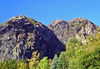
The park's lands, heavily mined, logged
and quarried
in the past, were assembled over the mid-20th century from different purchases by the state, totaling 7400 acres (2,994.7 ha) today. They range from riverside salt marsh
es to mountain summits, including the highest in the Highlands, the 1610 feet (490.7 m) south summit of Beacon Mountain
. It is managed by the New York State Office of Parks, Recreation and Historic Preservation
(NYSOPRHP) from offices at Fahnestock State Park to the east. Its parcels adjoin others owned by other public agencies and private preserves, some of which are managed by NYSOPRHP as well and open to the public.
Due to its proximity to New York City
, panoramic views of the river and mountains, and easy access by both automobile and rail, it has become a very popular destination for day hikes
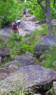
. The park's best known trail
makes a steep, rocky ascent up Breakneck Ridge
. Other trails climb neighboring Bull Hill
and follow the cliffs of Anthony's Nose
. The Appalachian Trail
(AT) also goes through the southeast corner of the park.
, abutting the New York National Guard's Camp Smith
, following the Bear Mountain Highway (US 6
and 202
) around the lower slopes of Anthony's Nose
. In Putnam County
, it serves as the AT's corridor along the north of the mountain and on Canada Hill. In the land above Manitoga, the former estate of industrial designer Russel Wright
, the AT interconnects with its trail system and follows the border with another parcel known as the Osborn Preserve, formerly part of Wing & Wing, the estate of 19th-century Illinois Central railroad president William Osborn.
The AT leaves the state park for a National Park Service
-owned corridor here, and the other trails provide access to Sugarloaf Hill
, whose 760 feet (231.6 m) summit looks across the river at the village of Highland Falls
and the United States Military Academy
at West Point
. Here, near Garrison
, the southern parcels end.
North of the villages of Cold Spring
and Nelsonville
is the central and largest section. Starting at the Little Stony Point area along the river, it is Broken slightly by the easement
for the New York City water supply system's Catskill Aqueduct
, it contains Bull Hill and Breakneck Ridge, with Breakneck Brook between them, then sprawls into Dutchess County
, where it includes Pollepel Island
, Sugarloaf Mountain, the south summit of Beacon Mountain
and Beacon Reservoir, reaching its northern terminus at the Dry Brook trailhead
at the end of Pocket Road in the city of Beacon
. It is complemented by Storm King State Park
across the river.
The Fishkill Ridge Conservation Area, owned by the environmental organization Scenic Hudson but managed by NYSOPRHP, bridges the gap between that central tract and the northern tract, a trail-less parcel on Sour Mountain at the Highlands' northern end, reaching almost to Interstate 84
at the bottom of the slope.
Also in Beacon is the 66 acres (26.7 ha) Denning Point parcel. This small wooded promontory
is located where Fishkill Creek
drains into the Hudson.
sailed up the Hudson in 1749 and wrote one of the earliest accounts of the eastern Highlands:
Kalm landed in the area and wrote the first scientific description of mountain laurel, a plant species still abundant in the area.
For most of American history, the Highlands were harvested for their natural resources, particularly mineral. Iron and copper were mined from them. Some of the former was used to make cannon
s by the Continental Army
during the Revolutionary War
, and the West Point Foundry
in Cold Spring continued making them under the direction of Robert Parrott through the late 19th century. Quarries
were also carved out of the slopes, most notably on Breakneck Ridge and Bull Hill.
 By the beginning of the 20th century, the eastern Highlands had been mostly tapped out as an easy source of minerals and were reforesting
. Early hikers began to explore them, following the abandoned paths and roads from the earlier extractions. One, William T. Howell, catalogued their history and lore. In 1910, he pleaded for the land to be left alone and preserved in near-wilderness condition as summer vacationers started to head north looking for green spaces:
to the southwest and Fahnestock to the east. Much of the present Hudson Highlands State Park was either part of large estates
or owned by commercial interests seeking to exploit their mineral resources. An organization called the Hudson River Conservation Society (HRCS) worked to preserve the lands by persuading owners to donate them to the state or include clauses in deed
s that forbade or greatly restricting quarrying and mining operations on the property.
In 1938 the society made its first significant accomplishment when it persuaded Rosalie Loew Whitney to give the state Conservation Department
177 acres (71.6 ha) on the northwest face of Breakneck Ridge from the estate of Thomas Nelson, the local landowner from whom Nelsonville took its name. The next year, an appeal to save Anthony's Nose raised enough money to purchase 200 acres (80.9 ha) of its northern slope.
No more major land acquisitions took place until the 1960s, when the State Parks Council, forerunner of NYSOPRHP, formed the temporary Hudson River Valley Study Committee to develop a comprehensive plan in response to increasing industrial interest in the area, exemplified by Consolidated Edison
's proposal to excavate a large chunk of Storm King Mountain, across from Breakneck, for a hydroelectric
plant, which would have involved running power lines across the river and into the eastern Highlands. In 1967 the state acquired the Little Stony Point property to prevent its development.
The park finally began to come together towards its present form in the next few years, as the Rockefeller family
's Jackson Hole Preserve foundation gave New York a deed of trust
for land purchases in the Hudson Highlands. Approximately 2500 acres (1,011.7 ha) were acquired this way, primarily in the large central parcel of the park along the Dutchess-Putnam county line. In 1974 William Henry Osborn II, a past HRCS president, donated the 1033 acres (418 ha) preserve that bears his family name to the state. Scenic Hudson acquired the 923 acres (373.5 ha) Fishkill Ridge Conservation Area in 1992 with assistance from the Lila Acheson and Dewitt Wallace
Fund for the Hudson Highlands.
The north end of the park became the center of a local controversy in the late 1990s. It is home to a den
of Eastern rattlesnakes
, a New York State threatened species
. The state's Department of Environmental Conservation
brought suit to stop the snake-proof fences a local quarry operator had put up while it was applying for permission to mine stone from the operation. In 1999 then-Attorney General
Elliot Spitzer persuaded a court to order the fence be torn down. It survived appeal, and became a legal precedent
establishing New York's right to enforce the state's Endangered Species Act on private property.
in the park comes from its collection of different biome
s, ranging from brackish tidal marsh
and mudflat
s along the river's edge to pitch pine-oak-heath rocky summit
forest and rocky grassland
s at higher elevations. In between the mountain slopes are dominated by oak hickory
and chestnut oak
forests.
Besides rattlesnakes, the park also supports some other state-listed threatened species, such as the bald eagle
and least bittern
. Three of New York's five known eastern fence lizard
communities are found in Hudson Highlands State Park, near the northern end of its range
.
, but also birding. Limited hunting
is allowed: bowhunters
make take deer
during that season
in the late fall, and shotgun
s may be used during spring turkey
season. Some areas near the riverside are accessible by kayak
, and there is a state-owned launch for them off the Annsville Circle, where US 9 meets routes 6 and 202, north of Peekskill. Camping
and open fires are prohibited, as are vehicles of any kind, and there are no designated campsites or shelters in the park.
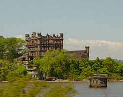 Pollepel Island
, while accessible by water a short distance from the east bank of the river, is the only area of the park to which access is restricted. It and the ruins of Bannerman's Castle, listed on the National Register of Historic Places
, can only be visited by making advance arrangements through NYSOPRHP for a guided tour.
runs near or along its boundaries, particularly between Cold Spring and Breakneck Ridge, and two of its major trailhead
s are along that section at Little Stony and Breakneck points. The Osborn Preserve and Anthony's Nose sections have trailheads along the Bear Mountain Highway and at the Appalachian Trail crossing at South Mountain Pass Road south of Canada Hill. The AT's junction with US 9 and NY 403
allows access from the east. In Garrison it is also possible to use the trails from Manitoga and the Castle Rock Unique Area to reach the park parcels on the ridgetops.
The Fishkill Ridge areas and Mount Beacon are commonly climbed from the east either by following the Fishkill Ridge trail from its northern terminus at Pocket Road in Beacon. From the west, they can be reached from the Wilkinson Memorial Trail on Old Albany Post Road North just south of the county line along US 9.
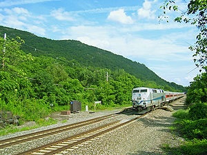 Hikers coming from the south also have the option of taking the train to the trails from as far away as Grand Central Terminal
in midtown Manhattan
. Metro-North Railroad
's Hudson Line
parallels NY 9D and the east bank of the river, where request stop
s have been built at Breakneck Ridge
and Manitou
, south of Garrison along the river. The former is a short distance from the trailhead and parking lot; the latter is at river's edge, requiring a short climb up to the Manitoga and Canada Hill areas. Service to those stations is weekends-only, with northbound trains making stops in the mornings and southbound ones taking returning hikers in the evening. At other times hikers can use the Cold Spring station
, with regularly scheduled trains.
with NYSOPRHP plastic disks, except for the Appalachian Trail which uses white paint blazes.
Many take advantage of the ridgetop topography and thinly wooded summits to offer panoramic viewpoints over the river and region. Some of the longer and more frequently-hiked trails in the park are:
State park
State parks are parks or other protected areas managed at the federated state level within those nations which use "state" as a political subdivision. State parks are typically established by a state to preserve a location on account of its natural beauty, historic interest, or recreational...
in the U.S. state of New York
New York
New York is a state in the Northeastern region of the United States. It is the nation's third most populous state. New York is bordered by New Jersey and Pennsylvania to the south, and by Connecticut, Massachusetts and Vermont to the east...
, located on the east side of the Hudson River
Hudson River
The Hudson is a river that flows from north to south through eastern New York. The highest official source is at Lake Tear of the Clouds, on the slopes of Mount Marcy in the Adirondack Mountains. The river itself officially begins in Henderson Lake in Newcomb, New York...
. The park runs from Peekskill
Peekskill, New York
Peekskill is a city in Westchester County, New York. It is situated on a bay along the east side of the Hudson River, across from Jones Point.This community was known to be an early American industrial center, primarily for its iron plow and stove products...
in Westchester County
Westchester County, New York
Westchester County is a county located in the U.S. state of New York. Westchester covers an area of and has a population of 949,113 according to the 2010 Census, residing in 45 municipalities...
, through Putnam County
Putnam County, New York
Putnam County is a county located in the U.S. state of New York, in the lower Hudson River Valley. Putnam county formed in 1812, when it detached from Dutchess County. , the population was 99,710. It is part of the New York Metropolitan Area. The county seat is the hamlet of Carmel...
, to Beacon
Beacon, New York
Beacon is a city located in Dutchess County, New York, United States. The 2010 census placed the city total population at 15,541. Beacon is part of the Poughkeepsie–Newburgh–Middletown, NY Metropolitan Statistical Area as well as the larger New York–Newark–Bridgeport,...
in Dutchess County
Dutchess County, New York
Dutchess County is a county located in the U.S. state of New York, in the state's Mid-Hudson Region of the Hudson Valley. The 2010 census lists the population as 297,488...
, in the eastern section of the Hudson Highlands
Hudson Highlands
The Hudson Highlands are mountains on both sides of the Hudson River in the U.S. state of New York, between Newburgh Bay and Haverstraw Bay, which form the northern region of the New York - New Jersey Highlands....
.
The park's lands, heavily mined, logged
Logging
Logging is the cutting, skidding, on-site processing, and loading of trees or logs onto trucks.In forestry, the term logging is sometimes used in a narrow sense concerning the logistics of moving wood from the stump to somewhere outside the forest, usually a sawmill or a lumber yard...
and quarried
Quarry
A quarry is a type of open-pit mine from which rock or minerals are extracted. Quarries are generally used for extracting building materials, such as dimension stone, construction aggregate, riprap, sand, and gravel. They are often collocated with concrete and asphalt plants due to the requirement...
in the past, were assembled over the mid-20th century from different purchases by the state, totaling 7400 acres (2,994.7 ha) today. They range from riverside salt marsh
Salt marsh
A salt marsh is an environment in the upper coastal intertidal zone between land and salt water or brackish water, it is dominated by dense stands of halophytic plants such as herbs, grasses, or low shrubs. These plants are terrestrial in origin and are essential to the stability of the salt marsh...
es to mountain summits, including the highest in the Highlands, the 1610 feet (490.7 m) south summit of Beacon Mountain
Beacon Mountain
Beacon Mountain, sometimes Mount Beacon, is the highest peak of the Hudson Highlands, located behind the City of Beacon, New York, in the Town of Fishkill. Its two summits rise above the Hudson River behind the city and can easily be seen from Newburgh across the river and many other places in the...
. It is managed by the New York State Office of Parks, Recreation and Historic Preservation
New York State Office of Parks, Recreation and Historic Preservation
The New York State Office of Parks, Recreation and Historic Preservation operates :*168 state parks*35 state historic sites*76 developed beaches*53 water recreational facilities*27 golf courses*39 full service cottages*818 cabins...
(NYSOPRHP) from offices at Fahnestock State Park to the east. Its parcels adjoin others owned by other public agencies and private preserves, some of which are managed by NYSOPRHP as well and open to the public.
Due to its proximity to New York City
New York City
New York is the most populous city in the United States and the center of the New York Metropolitan Area, one of the most populous metropolitan areas in the world. New York exerts a significant impact upon global commerce, finance, media, art, fashion, research, technology, education, and...
, panoramic views of the river and mountains, and easy access by both automobile and rail, it has become a very popular destination for day hikes
Hiking
Hiking is an outdoor activity which consists of walking in natural environments, often in mountainous or other scenic terrain. People often hike on hiking trails. It is such a popular activity that there are numerous hiking organizations worldwide. The health benefits of different types of hiking...
. The park's best known trail
Trail
A trail is a path with a rough beaten or dirt/stone surface used for travel. Trails may be for use only by walkers and in some places are the main access route to remote settlements...
makes a steep, rocky ascent up Breakneck Ridge
Breakneck Ridge
Breakneck Ridge is a mountain along the Hudson River between Beacon and Cold Spring, New York, straddling the boundary between Dutchess and Putnam counties...
. Other trails climb neighboring Bull Hill
Bull Hill
Bull Hill, also known as Mount Taurus, is a mountain north of the village of Cold Spring on the Hudson River in Putnam County in the State of New York. It is part of the river-straddling range known as the Hudson Highlands. The original name came after a bull that used to terrorize the mountain was...
and follow the cliffs of Anthony's Nose
Anthony's Nose (Westchester)
Anthony's Nose is a peak along the Hudson River at the north end of Westchester County, New York.- Topography :Anthony's Nose, together with Dunderberg Mountain, comprises the South Gate of the Hudson Highlands...
. The Appalachian Trail
Appalachian Trail
The Appalachian National Scenic Trail, generally known as the Appalachian Trail or simply the AT, is a marked hiking trail in the eastern United States extending between Springer Mountain in Georgia and Mount Katahdin in Maine. It is approximately long...
(AT) also goes through the southeast corner of the park.
Geography
The park is composed of four separate tracts of land, two of which are contiguous, reflecting its piecemeal acquisition. The southernmost section begins just north of PeekskillPeekskill, New York
Peekskill is a city in Westchester County, New York. It is situated on a bay along the east side of the Hudson River, across from Jones Point.This community was known to be an early American industrial center, primarily for its iron plow and stove products...
, abutting the New York National Guard's Camp Smith
Camp Smith (New York)
Camp Smith is a military installation of the New York Army National Guard in Cortlandt Manor near Peekskill, NY, about north of New York City, at the northern border of Westchester County, and consists of...
, following the Bear Mountain Highway (US 6
U.S. Route 6 in New York
U.S. Route 6 is a part of the U.S. Highway System that runs from Bishop, California, to Provincetown, Massachusetts. In New York, US 6 extends from the Pennsylvania state line at Port Jervis to the Connecticut state line east of Brewster...
and 202
U.S. Route 202 in New York
U.S. Route 202 is a part of the U.S. Highway System that runs from New Castle, Delaware, to Bangor, Maine. In the U.S. state of New York, US 202 extends from the New Jersey state line near Suffern to the Connecticut state line east of Brewster. While most of US 202 is signed...
) around the lower slopes of Anthony's Nose
Anthony's Nose (Westchester)
Anthony's Nose is a peak along the Hudson River at the north end of Westchester County, New York.- Topography :Anthony's Nose, together with Dunderberg Mountain, comprises the South Gate of the Hudson Highlands...
. In Putnam County
Putnam County, New York
Putnam County is a county located in the U.S. state of New York, in the lower Hudson River Valley. Putnam county formed in 1812, when it detached from Dutchess County. , the population was 99,710. It is part of the New York Metropolitan Area. The county seat is the hamlet of Carmel...
, it serves as the AT's corridor along the north of the mountain and on Canada Hill. In the land above Manitoga, the former estate of industrial designer Russel Wright
Russel Wright
Russel Wright was an American Industrial designer during the 20th century. Beginning in the late 1920s through the 1960s, Russel Wright created a succession of artistically distinctive and commercially successful items that helped bring modern design to the general public.-Designer:Russel...
, the AT interconnects with its trail system and follows the border with another parcel known as the Osborn Preserve, formerly part of Wing & Wing, the estate of 19th-century Illinois Central railroad president William Osborn.
The AT leaves the state park for a National Park Service
National Park Service
The National Park Service is the U.S. federal agency that manages all national parks, many national monuments, and other conservation and historical properties with various title designations...
-owned corridor here, and the other trails provide access to Sugarloaf Hill
Sugarloaf Hill (Hudson Highlands)
Sugarloaf Hill is a peak along the Hudson River in Putnam County, New York, part of the Hudson Highlands. It was named by the Dutch for its resemblance in outline to a sugarloaf when sailing up the river towards it.-Topography:...
, whose 760 feet (231.6 m) summit looks across the river at the village of Highland Falls
Highland Falls, New York
Highland Falls, formerly named Buttermilk Falls, is a village in Orange County, New York, United States. The population was 3,678 at the 2000 census. The village was founded in 1906...
and the United States Military Academy
United States Military Academy
The United States Military Academy at West Point is a four-year coeducational federal service academy located at West Point, New York. The academy sits on scenic high ground overlooking the Hudson River, north of New York City...
at West Point
West Point, New York
West Point is a federal military reservation established by President of the United States Thomas Jefferson in 1802. It is a census-designated place located in Town of Highlands in Orange County, New York, United States. The population was 7,138 at the 2000 census...
. Here, near Garrison
Garrison, New York
Garrison is a hamlet in Putnam County, New York, United States. It is part of the town of Philipstown and is on the east side of the Hudson River, across from the United States Military Academy at West Point...
, the southern parcels end.
North of the villages of Cold Spring
Cold Spring, New York
Cold Spring is a village located in the Town of Philipstown in Putnam County, New York. The population was 1,983 at the 2000 census. It borders the smaller village of Nelsonville...
and Nelsonville
Nelsonville, New York
Nelsonville is a Hudson Highlands village located in the Town of Philipstown in Putnam County, New York. The population was 565 at the time of the 2000 census.The Village of Nelsonville is directly east of the Village of Cold Spring...
is the central and largest section. Starting at the Little Stony Point area along the river, it is Broken slightly by the easement
Easement
An easement is a certain right to use the real property of another without possessing it.Easements are helpful for providing pathways across two or more pieces of property or allowing an individual to fish in a privately owned pond...
for the New York City water supply system's Catskill Aqueduct
Catskill Aqueduct
The Catskill Aqueduct, part of the New York City water supply system, brings water from the Catskill Mountains to Yonkers where it connects to other parts of the system.-History:Construction commenced in 1907...
, it contains Bull Hill and Breakneck Ridge, with Breakneck Brook between them, then sprawls into Dutchess County
Dutchess County, New York
Dutchess County is a county located in the U.S. state of New York, in the state's Mid-Hudson Region of the Hudson Valley. The 2010 census lists the population as 297,488...
, where it includes Pollepel Island
Pollepel Island
Pollepel Island is an island in the Hudson River.Also known as Pollopel Island, Pollopel's Island, and Bannerman Island, it is the site of Bannerman's Castle...
, Sugarloaf Mountain, the south summit of Beacon Mountain
Beacon Mountain
Beacon Mountain, sometimes Mount Beacon, is the highest peak of the Hudson Highlands, located behind the City of Beacon, New York, in the Town of Fishkill. Its two summits rise above the Hudson River behind the city and can easily be seen from Newburgh across the river and many other places in the...
and Beacon Reservoir, reaching its northern terminus at the Dry Brook trailhead
Trailhead
A trailhead is the point at which a trail begins, where the trail is often intended for hiking, biking, horseback riding, or off-road vehicles...
at the end of Pocket Road in the city of Beacon
Beacon, New York
Beacon is a city located in Dutchess County, New York, United States. The 2010 census placed the city total population at 15,541. Beacon is part of the Poughkeepsie–Newburgh–Middletown, NY Metropolitan Statistical Area as well as the larger New York–Newark–Bridgeport,...
. It is complemented by Storm King State Park
Storm King State Park
Storm King State Park is a state park in Orange County, New York in the USA. The park is in the southeast part of the Town of Cornwall, next to the Hudson River.The park is undeveloped, with limited parking, and offers hiking, and seasonal deer hunting....
across the river.
The Fishkill Ridge Conservation Area, owned by the environmental organization Scenic Hudson but managed by NYSOPRHP, bridges the gap between that central tract and the northern tract, a trail-less parcel on Sour Mountain at the Highlands' northern end, reaching almost to Interstate 84
Interstate 84 in New York
Interstate 84 is a part of the Interstate Highway System that runs from Dunmore, Pennsylvania, to Sturbridge, Massachusetts, in the Eastern United States. In New York, I-84 extends from the Pennsylvania state line at Port Jervis to the Connecticut state line east of Brewster...
at the bottom of the slope.
Also in Beacon is the 66 acres (26.7 ha) Denning Point parcel. This small wooded promontory
Promontory
Promontory may refer to:*Promontory, a prominent mass of land which overlooks lower lying land or a body of water*Promontory, Utah, the location where the United States first Transcontinental Railroad was completed...
is located where Fishkill Creek
Fishkill Creek
Fishkill Creek is a tributary of the Hudson River in Dutchess County, New York, United States. At it is the second longest stream in the county, after Wappinger Creek. It rises in the town of Union Vale and flows generally southwest to a small estuary on the Hudson just south of Beacon. Part of...
drains into the Hudson.
The Eastern Highlands before the 20th century
Swedish botanist Pehr KalmPehr Kalm
Pehr Kalm was a Swedish-Finnish explorer, botanist, naturalist, and agricultural economist. He was one of most important apostles of Carl Linnaeus...
sailed up the Hudson in 1749 and wrote one of the earliest accounts of the eastern Highlands:
Kalm landed in the area and wrote the first scientific description of mountain laurel, a plant species still abundant in the area.
For most of American history, the Highlands were harvested for their natural resources, particularly mineral. Iron and copper were mined from them. Some of the former was used to make cannon
Cannon
A cannon is any piece of artillery that uses gunpowder or other usually explosive-based propellents to launch a projectile. Cannon vary in caliber, range, mobility, rate of fire, angle of fire, and firepower; different forms of cannon combine and balance these attributes in varying degrees,...
s by the Continental Army
Continental Army
The Continental Army was formed after the outbreak of the American Revolutionary War by the colonies that became the United States of America. Established by a resolution of the Continental Congress on June 14, 1775, it was created to coordinate the military efforts of the Thirteen Colonies in...
during the Revolutionary War
American Revolutionary War
The American Revolutionary War , the American War of Independence, or simply the Revolutionary War, began as a war between the Kingdom of Great Britain and thirteen British colonies in North America, and ended in a global war between several European great powers.The war was the result of the...
, and the West Point Foundry
West Point Foundry
The West Point Foundry was an early ironworks in Cold Spring, New York that operated from 1817 to 1911. Set up to remedy deficiencies in national armaments production after the War of 1812, it became most famous for its production of Parrott rifles and other munitions during the Civil War, although...
in Cold Spring continued making them under the direction of Robert Parrott through the late 19th century. Quarries
Quarry
A quarry is a type of open-pit mine from which rock or minerals are extracted. Quarries are generally used for extracting building materials, such as dimension stone, construction aggregate, riprap, sand, and gravel. They are often collocated with concrete and asphalt plants due to the requirement...
were also carved out of the slopes, most notably on Breakneck Ridge and Bull Hill.
Reforestation
Reforestation is the natural or intentional restocking of existing forests and woodlands that have been depleted, usually through deforestation....
. Early hikers began to explore them, following the abandoned paths and roads from the earlier extractions. One, William T. Howell, catalogued their history and lore. In 1910, he pleaded for the land to be left alone and preserved in near-wilderness condition as summer vacationers started to head north looking for green spaces:
Creation of park
As New York began creating its first state parks in the 1910s and 20s, it concentrated its efforts on larger tracts it had acquired such as Harriman and Bear MountainBear Mountain State Park
Bear Mountain State Park is located on the west side of the Hudson River in Orange and Rockland counties of New York. The park offers biking, hiking, boating, picnicking, swimming, cross-country skiing, cross-country running, sledding and ice skating...
to the southwest and Fahnestock to the east. Much of the present Hudson Highlands State Park was either part of large estates
Estate (house)
An estate comprises the houses and outbuildings and supporting farmland and woods that surround the gardens and grounds of a very large property, such as a country house or mansion. It is the modern term for a manor, but lacks the latter's now abolished jurisdictional authority...
or owned by commercial interests seeking to exploit their mineral resources. An organization called the Hudson River Conservation Society (HRCS) worked to preserve the lands by persuading owners to donate them to the state or include clauses in deed
Deed
A deed is any legal instrument in writing which passes, or affirms or confirms something which passes, an interest, right, or property and that is signed, attested, delivered, and in some jurisdictions sealed...
s that forbade or greatly restricting quarrying and mining operations on the property.
In 1938 the society made its first significant accomplishment when it persuaded Rosalie Loew Whitney to give the state Conservation Department
New York State Department of Environmental Conservation
The New York State Department of Environmental Conservation is responsible for the conservation, improvement, and protection of natural resources within the U.S. state of New York. It was founded in 1970, replacing the previous Conservation Department...
177 acres (71.6 ha) on the northwest face of Breakneck Ridge from the estate of Thomas Nelson, the local landowner from whom Nelsonville took its name. The next year, an appeal to save Anthony's Nose raised enough money to purchase 200 acres (80.9 ha) of its northern slope.
No more major land acquisitions took place until the 1960s, when the State Parks Council, forerunner of NYSOPRHP, formed the temporary Hudson River Valley Study Committee to develop a comprehensive plan in response to increasing industrial interest in the area, exemplified by Consolidated Edison
Consolidated Edison
Consolidated Edison, Inc. is one of the largest investor-owned energy companies in the United States, with approximately $14 billion in annual revenues and $36 billion in assets...
's proposal to excavate a large chunk of Storm King Mountain, across from Breakneck, for a hydroelectric
Hydroelectricity
Hydroelectricity is the term referring to electricity generated by hydropower; the production of electrical power through the use of the gravitational force of falling or flowing water. It is the most widely used form of renewable energy...
plant, which would have involved running power lines across the river and into the eastern Highlands. In 1967 the state acquired the Little Stony Point property to prevent its development.
The park finally began to come together towards its present form in the next few years, as the Rockefeller family
Rockefeller family
The Rockefeller family , the Cleveland family of John D. Rockefeller and his brother William Rockefeller , is an American industrial, banking, and political family of German origin that made one of the world's largest private fortunes in the oil business during the late 19th and early 20th...
's Jackson Hole Preserve foundation gave New York a deed of trust
Trust deed (real estate)
In real estate in the United States, a trust deed or deed of trust is a deed wherein legal title in real property is transferred to a trustee, which holds it as security for a loan between a borrower and lender...
for land purchases in the Hudson Highlands. Approximately 2500 acres (1,011.7 ha) were acquired this way, primarily in the large central parcel of the park along the Dutchess-Putnam county line. In 1974 William Henry Osborn II, a past HRCS president, donated the 1033 acres (418 ha) preserve that bears his family name to the state. Scenic Hudson acquired the 923 acres (373.5 ha) Fishkill Ridge Conservation Area in 1992 with assistance from the Lila Acheson and Dewitt Wallace
DeWitt Wallace
DeWitt Wallace , also known as William Roy was a United States magazine publisher. He co-founded Reader's Digest with his wife Lila Wallace and published the first issue in 1922.Born in St...
Fund for the Hudson Highlands.
The north end of the park became the center of a local controversy in the late 1990s. It is home to a den
Lair
Lair may refer to:*An animal's lair or home; see :Category:Shelters built or used by animals*Lair , a 2007 video game*In Scots language, lair refers to a burial-plot in a graveyard...
of Eastern rattlesnakes
Crotalus horridus
Crotalus horridus, the timber rattlesnake, is a species of venomous pitviper found in the eastern United States. This is the only rattlesnake species in most of the populous northeastern United States. No subspecies are currently recognized....
, a New York State threatened species
Threatened species
Threatened species are any speciesg animals, plants, fungi, etc.) which are vulnerable to endangerment in the near future.The World Conservation Union is the foremost authority on threatened species, and treats threatened species not as a single category, but as a group of three categories,...
. The state's Department of Environmental Conservation
New York State Department of Environmental Conservation
The New York State Department of Environmental Conservation is responsible for the conservation, improvement, and protection of natural resources within the U.S. state of New York. It was founded in 1970, replacing the previous Conservation Department...
brought suit to stop the snake-proof fences a local quarry operator had put up while it was applying for permission to mine stone from the operation. In 1999 then-Attorney General
New York State Attorney General
The New York State Attorney General is the chief legal officer of the State of New York. The office has been in existence in some form since 1626, under the Dutch colonial government of New York.The current Attorney General is Eric Schneiderman...
Elliot Spitzer persuaded a court to order the fence be torn down. It survived appeal, and became a legal precedent
Precedent
In common law legal systems, a precedent or authority is a principle or rule established in a legal case that a court or other judicial body may apply when deciding subsequent cases with similar issues or facts...
establishing New York's right to enforce the state's Endangered Species Act on private property.
Flora and fauna
BiodiversityBiodiversity
Biodiversity is the degree of variation of life forms within a given ecosystem, biome, or an entire planet. Biodiversity is a measure of the health of ecosystems. Biodiversity is in part a function of climate. In terrestrial habitats, tropical regions are typically rich whereas polar regions...
in the park comes from its collection of different biome
Biome
Biomes are climatically and geographically defined as similar climatic conditions on the Earth, such as communities of plants, animals, and soil organisms, and are often referred to as ecosystems. Some parts of the earth have more or less the same kind of abiotic and biotic factors spread over a...
s, ranging from brackish tidal marsh
Brackish marsh
Brackish marshes develop by salt marshes where a significant freshwater influx dilute the seawater to brackish levels of salinity. This commonly happens upstream salt marshes by estuaries of coastal rivers or near the mouths of coastal rivers with heavy freshwater discharges in the conditions of...
and mudflat
Mudflat
Mudflats or mud flats, also known as tidal flats, are coastal wetlands that form when mud is deposited by tides or rivers. They are found in sheltered areas such as bays, bayous, lagoons, and estuaries. Mudflats may be viewed geologically as exposed layers of bay mud, resulting from deposition of...
s along the river's edge to pitch pine-oak-heath rocky summit
Pine barrens
Pine barrens, pine plains, sand plains, or pinelands occur throughout the northeastern U.S. from New Jersey to Maine as well as the Midwest and Canada....
forest and rocky grassland
Grassland
Grasslands are areas where the vegetation is dominated by grasses and other herbaceous plants . However, sedge and rush families can also be found. Grasslands occur naturally on all continents except Antarctica...
s at higher elevations. In between the mountain slopes are dominated by oak hickory
Oak-hickory forest
The oak-hickory forest is a general type of North American forest ecosystem with a range extending from southern New England and New York, west to Iowa, and south to Northern Georgia. Smaller, isolated Oak-Hickory communities can also be found as far west as North Dakota, south to Florida and...
and chestnut oak
Chestnut oak
Quercus prinus , the chestnut oak, is a species of oak in the white oak group, Quercus sect. Quercus. It is native to the eastern United States, where it is one of the most important ridgetop trees from southern Maine southwest to central Mississippi, with an outlying northwestern population in...
forests.
Besides rattlesnakes, the park also supports some other state-listed threatened species, such as the bald eagle
Bald Eagle
The Bald Eagle is a bird of prey found in North America. It is the national bird and symbol of the United States of America. This sea eagle has two known sub-species and forms a species pair with the White-tailed Eagle...
and least bittern
Least Bittern
The Least Bittern is a small wading bird, the smallest heron found in the Americas.This bird's underparts and throat are white with light brown streaks. Their face and the sides of the neck are light brown; they have yellow eyes and a yellow bill. The adult male is glossy greenish black on the...
. Three of New York's five known eastern fence lizard
Eastern fence lizard
The eastern fence lizard is a medium-sized species of lizard found along forest edges, rock piles, and rotting logs or stumps in the eastern United States...
communities are found in Hudson Highlands State Park, near the northern end of its range
Range (biology)
In biology, the range or distribution of a species is the geographical area within which that species can be found. Within that range, dispersion is variation in local density.The term is often qualified:...
.
Public use and access
The park is open during daylight hours year-round. It is used mainly for passive recreation, mostly hikingHiking
Hiking is an outdoor activity which consists of walking in natural environments, often in mountainous or other scenic terrain. People often hike on hiking trails. It is such a popular activity that there are numerous hiking organizations worldwide. The health benefits of different types of hiking...
, but also birding. Limited hunting
Hunting
Hunting is the practice of pursuing any living thing, usually wildlife, for food, recreation, or trade. In present-day use, the term refers to lawful hunting, as distinguished from poaching, which is the killing, trapping or capture of the hunted species contrary to applicable law...
is allowed: bowhunters
Bowhunting
Bowhunting is the practice of killing game animals by archery. It has been a normal use of archery in every culture that had bows.- Technique :...
make take deer
White-tailed Deer
The white-tailed deer , also known as the Virginia deer or simply as the whitetail, is a medium-sized deer native to the United States , Canada, Mexico, Central America, and South America as far south as Peru...
during that season
Hunting season
A hunting season is the time when it is legal to hunt and kill a particular species.In the United States, each state has primary responsibility and authority over the hunting of wildlife that resides within state boundaries. State wildlife agencies that sell hunting licenses are the best source of...
in the late fall, and shotgun
Shotgun
A shotgun is a firearm that is usually designed to be fired from the shoulder, which uses the energy of a fixed shell to fire a number of small spherical pellets called shot, or a solid projectile called a slug...
s may be used during spring turkey
Wild Turkey
The Wild Turkey is native to North America and is the heaviest member of the Galliformes. It is the same species as the domestic turkey, which derives from the South Mexican subspecies of wild turkey .Adult wild turkeys have long reddish-yellow to grayish-green...
season. Some areas near the riverside are accessible by kayak
Kayak
A kayak is a small, relatively narrow, human-powered boat primarily designed to be manually propelled by means of a double blade paddle.The traditional kayak has a covered deck and one or more cockpits, each seating one paddler...
, and there is a state-owned launch for them off the Annsville Circle, where US 9 meets routes 6 and 202, north of Peekskill. Camping
Camping
Camping is an outdoor recreational activity. The participants leave urban areas, their home region, or civilization and enjoy nature while spending one or several nights outdoors, usually at a campsite. Camping may involve the use of a tent, caravan, motorhome, cabin, a primitive structure, or no...
and open fires are prohibited, as are vehicles of any kind, and there are no designated campsites or shelters in the park.
Pollepel Island
Pollepel Island is an island in the Hudson River.Also known as Pollopel Island, Pollopel's Island, and Bannerman Island, it is the site of Bannerman's Castle...
, while accessible by water a short distance from the east bank of the river, is the only area of the park to which access is restricted. It and the ruins of Bannerman's Castle, listed on the National Register of Historic Places
National Register of Historic Places
The National Register of Historic Places is the United States government's official list of districts, sites, buildings, structures, and objects deemed worthy of preservation...
, can only be visited by making advance arrangements through NYSOPRHP for a guided tour.
Access
The park is most frequently entered from its western side. NY 9DNew York State Route 9D
New York State Route 9D , also known as the Bear Mountain – Beacon Highway, is a north–south state highway that runs along the eastern shore of the Hudson River in New York in the United States. It starts at the eastern end of the Bear Mountain Bridge at U.S...
runs near or along its boundaries, particularly between Cold Spring and Breakneck Ridge, and two of its major trailhead
Trailhead
A trailhead is the point at which a trail begins, where the trail is often intended for hiking, biking, horseback riding, or off-road vehicles...
s are along that section at Little Stony and Breakneck points. The Osborn Preserve and Anthony's Nose sections have trailheads along the Bear Mountain Highway and at the Appalachian Trail crossing at South Mountain Pass Road south of Canada Hill. The AT's junction with US 9 and NY 403
New York State Route 403
New York State Route 403 is a short state highway located entirely within Putnam County. It connects NY 9D in Philipstown at its northern/western end to US 9 in Graymoor, where the Appalachian Trail crosses both highways...
allows access from the east. In Garrison it is also possible to use the trails from Manitoga and the Castle Rock Unique Area to reach the park parcels on the ridgetops.
The Fishkill Ridge areas and Mount Beacon are commonly climbed from the east either by following the Fishkill Ridge trail from its northern terminus at Pocket Road in Beacon. From the west, they can be reached from the Wilkinson Memorial Trail on Old Albany Post Road North just south of the county line along US 9.
Grand Central Terminal
Grand Central Terminal —often incorrectly called Grand Central Station, or shortened to simply Grand Central—is a terminal station at 42nd Street and Park Avenue in Midtown Manhattan in New York City, United States...
in midtown Manhattan
Midtown Manhattan
Midtown Manhattan, or simply Midtown, is an area of Manhattan, New York City home to world-famous commercial zones such as Rockefeller Center, Broadway, and Times Square...
. Metro-North Railroad
Metro-North Railroad
The Metro-North Commuter Railroad , trading as MTA Metro-North Railroad, or, more commonly, Metro-North, is a suburban commuter rail service that is run and managed by the Metropolitan Transportation Authority , an authority of New York State. It is the busiest commuter railroad in the United...
's Hudson Line
Hudson Line (Metro-North)
Metro-North Railroad's Hudson Line is a commuter rail line running north from New York City along the east shore of the Hudson River. Metro-North service ends at Poughkeepsie, with Amtrak's Empire Corridor trains continuing north to and beyond Albany...
parallels NY 9D and the east bank of the river, where request stop
Request stop
In public transport, a request stop or flag stop describes a stopping point at which trains or buses stop only on an as-need or request basis; that is, only if there are passengers to be picked up or dropped off. In this way, infrequently used stopping points can be served efficiently.Trains save...
s have been built at Breakneck Ridge
Breakneck Ridge (Metro-North station)
The Breakneck Ridge Metro-North Railroad station serves hikers and campers traveling to and from Breakneck Ridge, north of Cold Spring, New York, via the Hudson Line. Trains stop there on Saturdays, Sundays and holidays only...
and Manitou
Manitou (Metro-North station)
The Manitou Metro-North Railroad station , open part-time serves the residents of that hamlet in the southwestern corner of the Town of Philipstown in Putnam County, New York, via the Metro-North Hudson Line...
, south of Garrison along the river. The former is a short distance from the trailhead and parking lot; the latter is at river's edge, requiring a short climb up to the Manitoga and Canada Hill areas. Service to those stations is weekends-only, with northbound trains making stops in the mornings and southbound ones taking returning hikers in the evening. At other times hikers can use the Cold Spring station
Cold Spring (Metro-North station)
Cold Spring is a Metro-North Railroad station that serves the residents of Cold Spring, New York via the Hudson Line. Trains leave for New York City every hour on weekdays, and about every 25 minutes during rush hour...
, with regularly scheduled trains.
Trails
The trails of the park are maintained by volunteers from the New York-New Jersey Trail Conference, which also publishes detailed maps. Some follow, in whole or part, old woods roads left over from the quarrying and mining operations; at other times they climb the steep and rocky peaks directly. They are blazedTrail blazing
Trail blazing, or trailblazing, is the practice of marking paths in outdoor recreational areas with blazes, markings that follow each other at certain — though not necessarily exactly defined — distances and mark the direction of the trail...
with NYSOPRHP plastic disks, except for the Appalachian Trail which uses white paint blazes.
Many take advantage of the ridgetop topography and thinly wooded summits to offer panoramic viewpoints over the river and region. Some of the longer and more frequently-hiked trails in the park are:
- Appalachian TrailAppalachian TrailThe Appalachian National Scenic Trail, generally known as the Appalachian Trail or simply the AT, is a marked hiking trail in the eastern United States extending between Springer Mountain in Georgia and Mount Katahdin in Maine. It is approximately long...
(AT): A 5.1 miles (8.2 km) section of the Georgia-to-Maine long-distance trail passes through the southern portion of the park near the Osborn Preserve. From NY 9D just north of the Bear Mountain BridgeBear Mountain BridgeThe Bear Mountain Bridge is a toll suspension bridge in New York State, carrying U.S. Highways 202 and 6 across the Hudson River between Rockland and Westchester counties...
, it ascends Canada Hill and follows that ridge for two miles before descending to the US 9/NY 403 junction at Graymoor. - Breakneck Ridge Trail: One of the most popular trails in the park, due to the challenge of the westernmost section, which climbs 1250 feet (381 m) in its first 0.75 miles (1.2 km) through steep rocky chutes that require scramblingScramblingScrambling is a method of ascending rocky faces and ridges. It is an ambiguous term that lies somewhere between hillwalking and rock climbing. It is often distinguished from hillwalking by defining a scramble as a route where hands must be used in the ascent...
and offer views of Storm King and Newburgh BayNewburgh BayNewburgh Bay is in the Hudson River approximately 60 miles north of New York City, just upriver from the Hudson Highlands. It takes its name from Newburgh, for many years the major port on this section of the river....
. The entire trail, 4.6 miles (7.4 km) in length, continues over the mountain along the ridgetop to South Beacon Mountain. - Camp Smith Trail: This 3.7 miles (6 km) trail follows a narrow corridor through of parkland between the National Guard baseCamp Smith (New York)Camp Smith is a military installation of the New York Army National Guard in Cortlandt Manor near Peekskill, NY, about north of New York City, at the northern border of Westchester County, and consists of...
and the Bear Mountain HighwayBear Mountain Bridge RoadBear Mountain Bridge Road is a three-mile , two-lane section of US 6/202 from the west approach to Bear Mountain Bridge to a former toll house in the Town of Cortlandt, New York, United States. It winds around the steep, rocky slopes of Anthony's Nose, the southernmost peak of the Hudson Highlands...
, traversing Anthony's Nose. It has many steep and rocky sections with views of Bear MountainBear Mountain (New York)According to the , the state of New York in the United States has 11 peaks named Bear Mountain. The most widely known is in the Hudson Highlands of Orange County, just north of the New York metropolitan area and from which the name for Bear Mountain State Park is derived....
, the bridge and Haverstraw BayHaverstraw BayHaverstraw Bay, located in New York, is the widest portion of the Hudson River. The width of Haverstraw Bay is approximately 3.4 miles . The length approximately 5 miles from river kilometer 58 at Croton Point to river kilometer 66 at Stony Point...
to the south. - Fishkill Ridge Trail: Starting from the Pocket Road trailhead in Beacon, this 4.9 miles (7.9 km) trail makes a large loop over that mountain, offering some views over Fishkill and southern Dutchess County along the way.
- Notch Trail: Fornerly the Three Notch Trail, this 5.8 miles (9.3 km) trail follows wood roads from near the summit of Bull Hill, down into the col and up the north face of Breakneck Ridge. There it joins that trail for 1.3 miles (2.1 km) along the ridge, then descends the face of Sunset Point to Squirrel Hollow Brook and continues a long traverse across the lower slopes of South Beacon Mountain to reach Route 9D in Dutchess Junction south of Beacon, near Melzingah Brook.
- Osborn Loop: This 3.4 miles (5.5 km) trail connects to the AT near Canada Hill at both ends. It can be reached from Manitoga, the AT, or the trails around Sugarloaf Mountain.
- Undercliff Trail: A four-mile (6.4 km) route from Nelsonville to Breakneck Ridge that crosses the shoulder of Bull Hill along the way. It takes its name from the many cliffs whose foot it passes.
- Washburn Trail: The main route up Bull Hill from the Little Stony Point trailhead just north of Cold Spring climbs the mountain's 1420 feet (432.8 m) in almost 2.3 miles (3.7 km). This is the greatest vertical ascent of any trail within the park.
- Wilkinson Memorial Trail: Longest trail in Hudson Highlands State Park at 9.5 miles (15.3 km). It begins along NY 9D just north of Breakneck Ridge and gradually ascends to cross all the summits of Scofield Ridge, the highest peak in Putnam County, located outside the park. It descends from there to Old Albany Post Road North, just off US 9 near the county line.
External links
- New York State Parks: Hudson Highlands State Park
- Hudson Highlands Hiking, from the Putnam County News & Recorder
- NY-NJTC: Hudson Highlands State Park | Trail, Park and Volunteer Opportunity info