

Geography of the Netherlands
Encyclopedia
Netherlands
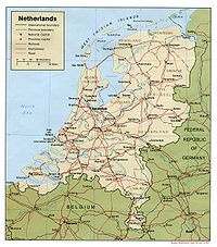
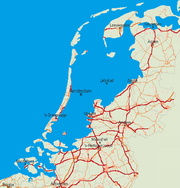
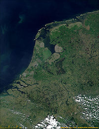
The Netherlands is a constituent country of the Kingdom of the Netherlands, located mainly in North-West Europe and with several islands in the Caribbean. Mainland Netherlands borders the North Sea to the north and west, Belgium to the south, and Germany to the east, and shares maritime borders...
is unusual in that much of its land has been reclaimed from the sea and is below sea level
Sea level
Mean sea level is a measure of the average height of the ocean's surface ; used as a standard in reckoning land elevation...
, protected by dikes. Another factor that has influenced its physical appearance is that the country is among the most densely populated on earth. It is ranked 15th overall on that scale, but is behind only three countries having a population over 10 million. Necessarily, the Netherlands is highly urbanised.
Landscape
The country can be split into two areas:- the low and flat lands in the west and north. These lands, including the reclaimed polderPolderA polder is a low-lying tract of land enclosed by embankments known as dikes, that forms an artificial hydrological entity, meaning it has no connection with outside water other than through manually-operated devices...
s and river deltaRiver deltaA delta is a landform that is formed at the mouth of a river where that river flows into an ocean, sea, estuary, lake, reservoir, flat arid area, or another river. Deltas are formed from the deposition of the sediment carried by the river as the flow leaves the mouth of the river...
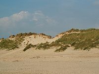
s, make up about half of its surface area and are less than 1 m (3.2 ft) above sea level, much of it actually below sea level. An extensive range of seawallSeawallA seawall is a form of coastal defence constructed where the sea, and associated coastal processes, impact directly upon the landforms of the coast. The purpose of a seawall is to protect areas of human habitation, conservation and leisure activities from the action of tides and waves...
s and coastal duneDuneIn physical geography, a dune is a hill of sand built by wind. Dunes occur in different forms and sizes, formed by interaction with the wind. Most kinds of dunes are longer on the windward side where the sand is pushed up the dune and have a shorter "slip face" in the lee of the wind...
s protect the Netherlands from the sea, and levees and dikes along the rivers protect against river flooding. - the higher lands with minor hills in the east and south. Even this portion is mostly flat; only in the extreme south of the country does the land rise to any significant extent, in the foothills of the ArdennesArdennesThe Ardennes is a region of extensive forests, rolling hills and ridges formed within the Givetian Ardennes mountain range, primarily in Belgium and Luxembourg, but stretching into France , and geologically into the Eifel...
mountains. This is where VaalserbergVaalserbergThe Vaalserberg is a hill 322.7 metres in height and the highest point in the European part of the Netherlands. The Vaalserberg is located in the province of Limburg, at the south-easternmost edge of the country in the municipality of Vaals, near the eponymous town, some three kilometres west of...
is located, the highest point on the European part of the Netherlands at 322.7 metres (1,058.7 ft) above sea level.
Statistics
Geographic coordinates: ca. 51° – 53° N, 4° – 7° E- 1 degree = 111 km NS, 68 km EW (the ratio is 0.61, the cosine of the latitude)
- 1 minute = 1,850 m NS (ca. 1 nautical mile), 1,140 m EW
- 1 second = 31 m NS, 19 m EW
The Dutch RD coordinate system (Rijksdriehoeksmeting) is also in common use; see https://rdinfo.kadaster.nl/pdf/rd_brochure.pdf (pdf, in Dutch; see little map on p. 1) and converter. There is a west-east coordinate between 0 and 280 km, and a south-north coordinate between 300 and 620 km.
The reference point is the Onze-Lieve-Vrouwentoren (Our Lady's Tower) in Amersfoort
Amersfoort
Amersfoort is a municipality and the second largest city of the province of Utrecht in central Netherlands. The city is growing quickly but has a well-preserved and protected medieval centre. Amersfoort is one of the largest railway junctions in the country, because of its location on two of the...
, with RD coordinates (155.000, 463.000) and geographic coordinates approximately 52°9′N 5°23′E.
Rate of change of solar time
Solar time
Solar time is a reckoning of the passage of time based on the Sun's position in the sky. The fundamental unit of solar time is the day. Two types of solar time are apparent solar time and mean solar time .-Introduction:...
: 1 minute per 17 km EW.
Highest altitude
Altitude
Altitude or height is defined based on the context in which it is used . As a general definition, altitude is a distance measurement, usually in the vertical or "up" direction, between a reference datum and a point or object. The reference datum also often varies according to the context...
of the Sun varies at the center from 38.5 − 23.5 = 15 degrees in December to 38.5 + 23.5 = 62 degrees in June. This occurs, depending on east-west location, at ca. 11:40 UTC, i.e. local time 12:40 in winter and 13:40 in summer.
Europe
Europe
Europe is, by convention, one of the world's seven continents. Comprising the westernmost peninsula of Eurasia, Europe is generally 'divided' from Asia to its east by the watershed divides of the Ural and Caucasus Mountains, the Ural River, the Caspian and Black Seas, and the waterways connecting...
Area:
total: 41526 km² (16,033 sq mi)
land: 33883 km² (13,082 sq mi)
water: 7643 km² (2,951 sq mi)
Land boundaries:
total: 1027 km (638 mi)
border countries:
- BelgiumBelgiumBelgium , officially the Kingdom of Belgium, is a federal state in Western Europe. It is a founding member of the European Union and hosts the EU's headquarters, and those of several other major international organisations such as NATO.Belgium is also a member of, or affiliated to, many...
450 km (280 mi) - GermanyGermanyGermany , officially the Federal Republic of Germany , is a federal parliamentary republic in Europe. The country consists of 16 states while the capital and largest city is Berlin. Germany covers an area of 357,021 km2 and has a largely temperate seasonal climate...
577 km (359 mi)
Coastline: 451 km (280 mi)
Maritime claims:
exclusive fishing zone: 200 nmi (370.4 km; 230.2 mi)
territorial sea: 12 nmi (22.2 km; 13.8 mi)
Climate: temperate
Temperate
In geography, temperate or tepid latitudes of the globe lie between the tropics and the polar circles. The changes in these regions between summer and winter are generally relatively moderate, rather than extreme hot or cold...
; marine; cool summers and mild winters
Terrain: mostly coastal lowland and reclaimed land (polder
Polder
A polder is a low-lying tract of land enclosed by embankments known as dikes, that forms an artificial hydrological entity, meaning it has no connection with outside water other than through manually-operated devices...
s); some hills in southeast
Elevation extremes:
lowest point: Zuidplaspolder (Nieuwerkerk aan den IJssel
Nieuwerkerk aan den IJssel
Nieuwerkerk aan den IJssel is a town and former municipality in the western Netherlands, in the province of South Holland...
) -7 m, below sea level.
highest point: Mount Scenery
Mount Scenery
Mount Scenery is a potentially active volcano in the Caribbean Netherlands. Its lava dome forms the summit of the Saba island stratovolcano. At an elevation of 877 m, it is the highest point in both the Kingdom of the Netherlands, and, since the dissolution of the Netherlands Antilles on 10...
877 m (2,877.3 ft) above sea level.
highest point on European mainland: Vaalserberg
Vaalserberg
The Vaalserberg is a hill 322.7 metres in height and the highest point in the European part of the Netherlands. The Vaalserberg is located in the province of Limburg, at the south-easternmost edge of the country in the municipality of Vaals, near the eponymous town, some three kilometres west of...
322.7 m (1,058.7 ft) above sea level.
Natural resources: natural gas
Natural gas
Natural gas is a naturally occurring gas mixture consisting primarily of methane, typically with 0–20% higher hydrocarbons . It is found associated with other hydrocarbon fuel, in coal beds, as methane clathrates, and is an important fuel source and a major feedstock for fertilizers.Most natural...
, petroleum
Petroleum
Petroleum or crude oil is a naturally occurring, flammable liquid consisting of a complex mixture of hydrocarbons of various molecular weights and other liquid organic compounds, that are found in geologic formations beneath the Earth's surface. Petroleum is recovered mostly through oil drilling...
, arable land
Land use: (1996 est.)
arable land: 25%
permanent crops: 3%
permanent pastures: 25%
forests and woodland: 8%
other: 39%
Irrigated land (1996 est.): 6000 km² (2,317 sq mi)
Natural hazards: flooding by sea and rivers is a constant danger. The extensive system of dikes, dams, and sand dunes protect nearly one-half of the total area from being flooded during the heavy autumn storms from the north-west.
Environment – current issues: water pollution
Water pollution
Water pollution is the contamination of water bodies . Water pollution occurs when pollutants are discharged directly or indirectly into water bodies without adequate treatment to remove harmful compounds....
in the form of heavy metals
Heavy metals
A heavy metal is a member of a loosely-defined subset of elements that exhibit metallic properties. It mainly includes the transition metals, some metalloids, lanthanides, and actinides. Many different definitions have been proposed—some based on density, some on atomic number or atomic weight,...
, organic compounds, and fetilisers such as nitrates and phosphates; air pollution from vehicles and refining activities; acid rain
Acid rain
Acid rain is a rain or any other form of precipitation that is unusually acidic, meaning that it possesses elevated levels of hydrogen ions . It can have harmful effects on plants, aquatic animals, and infrastructure. Acid rain is caused by emissions of carbon dioxide, sulfur dioxide and nitrogen...
Environment – international agreements:
party to:
Air Pollution, Air Pollution-Nitrogen Oxides, Air Pollution-Sulphur 85, Air Pollution-Sulphur 94, Air Pollution-Volatile Organic Compounds, Antarctic-Environmental Protocol, Antarctic Treaty, Biodiversity, Climate Change, Desertification, Endangered Species, Environmental Modification, Hazardous Wastes, Law of the Sea, Marine Dumping, Marine Life Conservation, Nuclear Test Ban, Ozone Layer Protection, Ship Pollution, Tropical Timber 83, Tropical Timber 94, Wetlands, Whaling
signed, but not ratified:
Air Pollution-Persistent Organic Pollutants, Biodiversity, Climate Change-Kyoto Protocol
Geography – note: located at mouths of three major European rivers (Rhine, Maas or Meuse, and Scheldt
Scheldt
The Scheldt is a 350 km long river in northern France, western Belgium and the southwestern part of the Netherlands...
)
Largest cities
Sources are CBS basedsee https://www.cbs.nl/NR/rdonlyres/4A8AA094-7050-44...; and
2005grootstedelijkeagglomeratiesstadsgewestenafgebakendart.pdf
2004k4v4p037art.pdf
with their provinces in 2006:
- AmsterdamAmsterdamAmsterdam is the largest city and the capital of the Netherlands. The current position of Amsterdam as capital city of the Kingdom of the Netherlands is governed by the constitution of August 24, 1815 and its successors. Amsterdam has a population of 783,364 within city limits, an urban population...
(North Holland) 744,740 inhabitants - RotterdamRotterdamRotterdam is the second-largest city in the Netherlands and one of the largest ports in the world. Starting as a dam on the Rotte river, Rotterdam has grown into a major international commercial centre...
(South Holland) 581,615 inh. - The HagueThe HagueThe Hague is the capital city of the province of South Holland in the Netherlands. With a population of 500,000 inhabitants , it is the third largest city of the Netherlands, after Amsterdam and Rotterdam...
('s-Gravenhage) (South Holland) 474,245 inh. - UtrechtUtrecht (city)Utrecht city and municipality is the capital and most populous city of the Dutch province of Utrecht. It is located in the eastern corner of the Randstad conurbation, and is the fourth largest city of the Netherlands with a population of 312,634 on 1 Jan 2011.Utrecht's ancient city centre features...
(Utrecht) 290,529 inh. - Eindhoven (North Brabant) 209,601 inh.
- TilburgTilburgTilburg is a landlocked municipality and a city in the Netherlands, located in the southern province of Noord-Brabant.Tilburg municipality also includes the villages of Berkel-Enschot and Udenhout....
(North Brabant) 200,975 inh. - AlmereAlmereAlmere is a planned city and municipality in the province of Flevoland, the Netherlands, bordering Lelystad and Zeewolde. The municipality of Almere comprises the districts Almere Stad, Almere Haven, Almere Buiten, Almere Hout, Almere Poort and Almere Pampus .Almere is the youngest city in the...
(Flevoland) 181,990 inh. - Groningen (Groningen) 180,824 inh.
- BredaBredaBreda is a municipality and a city in the southern part of the Netherlands. The name Breda derived from brede Aa and refers to the confluence of the rivers Mark and Aa. As a fortified city, the city was of strategic military and political significance...
(North Brabant) 170,451 inh. - Nijmegen (Gelderland) 160,732 inh.
- ApeldoornApeldoornApeldoorn is a municipality and city in the province of Gelderland, about 60 miles south east of Amsterdam, in the centre of the Netherlands. It is a regional centre and has 155,000 . The municipality of Apeldoorn, including villages like Beekbergen, Loenen and Hoenderloo, has over 155,000...
(Gelderland) 155,328 inh. - EnschedeEnschedeEnschede , also known as Eanske in the local dialect of Twents, is a municipality and a city in the eastern Netherlands in the province of Overijssel and in the Twente region...
(Overijssel) 154,311 inh. - HaarlemHaarlemHaarlem is a municipality and a city in the Netherlands. It is the capital of the province of North Holland, the northern half of Holland, which at one time was the most powerful of the seven provinces of the Dutch Republic...
(North Holland) 147,179 inh. - ArnhemArnhemArnhem is a city and municipality, situated in the eastern part of the Netherlands. It is the capital of the province of Gelderland and located near the river Nederrijn as well as near the St. Jansbeek, which was the source of the city's development. Arnhem has 146,095 residents as one of the...
(Gelderland) 142,638 inh. - ZaanstadZaanstadZaanstad is a municipality in the Netherlands, in the province of North Holland. Its main town is Zaandam. It is part of the metropolitan area of Amsterdam.-Population centres:...
(North Holland) 141,829 inh. - AmersfoortAmersfoortAmersfoort is a municipality and the second largest city of the province of Utrecht in central Netherlands. The city is growing quickly but has a well-preserved and protected medieval centre. Amersfoort is one of the largest railway junctions in the country, because of its location on two of the...
(Utrecht) 139,914 inh. - HaarlemmermeerHaarlemmermeerHaarlemmermeer is a municipality in the Netherlands, in the province of North Holland. It is a polder, consisting of land reclaimed from water, and the name Haarlemmermeer means Haarlem's Lake, still referring to the body of water from which the region was reclaimed in the 19th century.Its main...
(municipal seat: HoofddorpHoofddorpHoofddorp is the main town of the Haarlemmermeer municipality in the province of North Holland in the Netherlands. In 2009, the population was just over 73,000...
) (North Holland) 139,396 inh. - 's-Hertogenbosch (North Brabant) 135,787 inh.
- ZoetermeerZoetermeerZoetermeer is a city in the western Netherlands, in the province of South Holland. The municipality covers an area of 37.06 km² . A small village until the late 1960s, it had 6,392 inhabitants in 1950...
(South Holland) 118,534 inh. - DordrechtDordrechtDordrecht , colloquially Dordt, historically in English named Dort, is a city and municipality in the western Netherlands, located in the province of South Holland. It is the fourth largest city of the province, having a population of 118,601 in 2009...
(South Holland) 118,443 inh. - MaastrichtMaastrichtMaastricht is situated on both sides of the Meuse river in the south-eastern part of the Netherlands, on the Belgian border and near the German border...
(Limburg) 118,378 inh. - Leiden (South Holland) 117,363 inh.
- ZwolleZwolleZwolle is a municipality and the capital city of the province of Overijssel, Netherlands, 120 kilometers northeast of Amsterdam. Zwolle has about 120,000 citizens.-History:...
(Overijssel) 115,144 inh. - EdeEde, Netherlands' is a municipality and a town in the center of the Netherlands, in the province of Gelderland.- Population centres :Community :* Bennekom: 14.749* De Klomp: 508* Deelen: 50* Ede : 67.812* Ederveen: 3.167* Harskamp: 3.464...
(Gelderland) 107,528 inh. - VenloVenloVenlo is a municipality and a city in the southeastern Netherlands, next to the German border. It is situated in the province of Limburg.In 2001, the municipalities of Belfeld and Tegelen were merged into the municipality of Venlo. Tegelen was originally part of the Duchy of Jülich centuries ago,...
(Limburg) 100,271 inh. - Westland (municipal seat: NaaldwijkNaaldwijkNaaldwijk is a town in the Dutch province of South Holland. It is a part of the municipality of Westland, and lies about 10 km southwest of The Hague.Naaldwijk lies in the heart of Westland. The largest economic sector is greenhouse horticulture...
) (South Holland) 99,067 inh. - DeventerDeventerDeventer is a municipality and city in the Salland region of the Dutch province of Overijssel. Deventer is largely situated on the east bank of the river IJssel, but also has a small part of its territory on the west bank. In 2005 the municipality of Bathmen Deventer is a municipality and city in...
(Overijssel) 96,958 inh. - Sittard-GeleenSittard-GeleenSittard-Geleen is a municipality in the southeastern Netherlands. It was formed in 2001 from the former municipalities Sittard, Geleen and Born....
(municipal seat: SittardSittardSittard is a city in the Dutch province of Limburg, which is the southernmost province of the Netherlands.On the east Sittard borders on Germany . It has some 48,400 inhabitants . Sittard is part of the municipality of Sittard-Geleen...
) (Limburg) 96,024 inh. - DelftDelftDelft is a city and municipality in the province of South Holland , the Netherlands. It is located between Rotterdam and The Hague....
(South Holland) 95,237 inh. - AlkmaarAlkmaarAlkmaar is a municipality and a city in the Netherlands, in the province of Noord Holland. Alkmaar is well known for its traditional cheese market. For tourists, it is a popular cultural destination.-History:...
(North Holland) 93,986 inh.
Largest agglomerations
Sources are based on CBSsee https://www.cbs.nl/NR/rdonlyres/4A8AA094-7050-44... and
- AmsterdamAmsterdamAmsterdam is the largest city and the capital of the Netherlands. The current position of Amsterdam as capital city of the Kingdom of the Netherlands is governed by the constitution of August 24, 1815 and its successors. Amsterdam has a population of 783,364 within city limits, an urban population...
(Amsterdam, Amstelveen, Diemen, Landsmeer, Oostzaan, Wormerland, Zaanstad) - RotterdamRotterdamRotterdam is the second-largest city in the Netherlands and one of the largest ports in the world. Starting as a dam on the Rotte river, Rotterdam has grown into a major international commercial centre...
(Rotterdam, Barendrecht, Capelle aan den IJssel, Krimpen aan den IJssel, Spijkenisse, Schiedam, Vlaardingen, Maasland, Maassluis, Rozenburg) - The HagueThe HagueThe Hague is the capital city of the province of South Holland in the Netherlands. With a population of 500,000 inhabitants , it is the third largest city of the Netherlands, after Amsterdam and Rotterdam...
('s-Gravenhage, Rijswijk, Wateringen, Voorburg, Leidschendam, Wassenaar) - UtrechtUtrecht (agglomeration)The city of Utrecht and the surrounding cities, villages, and townships form an agglomeration in the middle of The Netherlands. It is located entirely in the province of Utrecht, and is the eastern part of so-called North Wing the larger Randstad urban area....
(Utrecht, Nieuwegein, IJsselstein, Maarssen) - Eindhoven (Eindhoven, Veldhoven, Geldrop, Son en Breugel, Waalre)
- BredaBredaBreda is a municipality and a city in the southern part of the Netherlands. The name Breda derived from brede Aa and refers to the confluence of the rivers Mark and Aa. As a fortified city, the city was of strategic military and political significance...
(Breda, Oosterhout, Etten-Leur, Drimmelen, Zundert) - TilburgTilburgTilburg is a landlocked municipality and a city in the Netherlands, located in the southern province of Noord-Brabant.Tilburg municipality also includes the villages of Berkel-Enschot and Udenhout....
(Tilburg, Goirle) - HaarlemHaarlemHaarlem is a municipality and a city in the Netherlands. It is the capital of the province of North Holland, the northern half of Holland, which at one time was the most powerful of the seven provinces of the Dutch Republic...
(Haarlem, Heemstede, Bloemendaal) - Groningen (Groningen, Haren)
- ArnhemArnhemArnhem is a city and municipality, situated in the eastern part of the Netherlands. It is the capital of the province of Gelderland and located near the river Nederrijn as well as near the St. Jansbeek, which was the source of the city's development. Arnhem has 146,095 residents as one of the...
(Arnhem, Rozendaal) - Leiden (Leiden, Katwijk, Voorschoten, Leiderdorp, Oegstgeest, Rijnsburg, Valkenburg, Warmond)
- DordrechtDordrechtDordrecht , colloquially Dordt, historically in English named Dort, is a city and municipality in the western Netherlands, located in the province of South Holland. It is the fourth largest city of the province, having a population of 118,601 in 2009...
(Dordrecht, 's-Gravendeel, Hardinxveld-Giessendam, Papendrecht, Sliedrecht, Zwijndrecht) - HeerlenHeerlenHeerlen is a city and a municipality in the southeastern Netherlands. The municipality is the second largest in the province of Limburg. It forms part of Parkstad Limburg, , an agglomeration of about 220,000 inhabitants.After its early Roman beginnings and a rather modest medieval period, Heerlen...
(Heerlen, Kerkrade, Landgraaf, Brunssum) - 's-Hertogenbosch ('s-Hertogenbosch, Vught)
- Sittard-GeleenSittard-GeleenSittard-Geleen is a municipality in the southeastern Netherlands. It was formed in 2001 from the former municipalities Sittard, Geleen and Born....
(Sittard-Geleen, Beek, Stein) - AmersfoortAmersfoortAmersfoort is a municipality and the second largest city of the province of Utrecht in central Netherlands. The city is growing quickly but has a well-preserved and protected medieval centre. Amersfoort is one of the largest railway junctions in the country, because of its location on two of the...
(Amersfoort, Leusden)
See also
- List of islands of the Netherlands
- List of places in the Netherlands
- Extreme points of the NetherlandsExtreme points of the NetherlandsThis is a list of the extreme points of the Netherlands, the points that are farther north, south, east or west than any other location.-European part of the Netherlands:*Northernmost Point — Rottumerplaat...
- Netherlands: Climate
External links
- Map showing first two digits of postal codes (see List of postal codes in the Netherlands), ditto
- Locate town or village; find municipality it is part of, range of postal codes, and some other basic data
- Lists of "places" (towns, villages, and various smaller entities), with municipality: alphabetical (ca. 4,800) – by province (extended, ca. 7,000)
Maps
- Routenet.nl Most used website for maps and directions in the Netherlands, also gives address range for a full postal code, and shows the four-digit parts of the postal codes on the maps. Published by Locatienet BV
- Multimap – shows geographic coordinates and allows a direct link to a map for a given location and with a given zoom level; shows all railways from scale 1:500k, all railway stations from 1:50k
- http://www.map24.nl/index.php?language=en
- http://www.welkeafslag.nl (Online website which can calcalute the directions to travel between two addresses)
- http://www.routemaster.nl/ ; similar or the same:
- http://route.anwb.nl/zoek_plattegrond.html
- maps of public transport planner http://www.9292ov.nl
- http://www.mapquest.com/maps/map.adp?country=NL&zoom=3
- to link directly to a city: http://www.mapquest.com/maps/map.adp?country=NL&city=, type city at the end of the URL
- to link directly to a postal code: http://www.mapquest.com/maps/map.adp?country=NL&zipcode=, type four-digit code at the end of the URL
- to link to given geographic coordinates: latlongtype=decimal&latitude=...&longitude=... – a red star shows the location on the map; in the largest scale one pixel is ca. 1.5 m or from 0.000015 degrees; therefore for the number of degrees up to five decimals can make sense for exact pinpointing (although the star size is 16x16 pixels and not transparent, hence a small map detail and ca. one letter of text may be covered by the star)
- specify zoom level 0–9: add "&zoom=zoom level" (note that the zoom level in MapQuest's hoverbox have numbers which are one more, the range is 1–10)
- http://de.maps.yahoo.com/py/maps.py?country=nl
- Michelin
- Yellow pages / Telephone directory – A map (plattegrond) is provided after searching for a company or person
- Topographical Service map selection tool (can to some extent be used as a map by itself)
- See also the links of:
- http://www.landkaartenindex.nl/nederland/nederland.htm ; includes http://www.landkaartenindex.nl/nederland/nl_stadsplattegrond.htm, a list of links to towns maps
- Detailed town maps of Rijnland/Citoplan (note that on the overview maps, for enlargement one can often either select a box or a town and then a box)
For public transport maps see Transportation in the Netherlands#External links.
Satellite images and aerial photographs
Google MapsGoogle Maps
Google Maps is a web mapping service application and technology provided by Google, free , that powers many map-based services, including the Google Maps website, Google Ride Finder, Google Transit, and maps embedded on third-party websites via the Google Maps API...
http://maps.google.co.uk/maps?ll=51.569824,5.031738&spn=4.529663,6.470947&t=k&hl=en has aerial photographs of the entire country, combined with a full map with town and street names. This is also available through Google Earth
Google Earth
Google Earth is a virtual globe, map and geographical information program that was originally called EarthViewer 3D, and was created by Keyhole, Inc, a Central Intelligence Agency funded company acquired by Google in 2004 . It maps the Earth by the superimposition of images obtained from satellite...
.
Footnotes and References
↑ [3] [4]:- 2006bevolkingskerneninnederlandart.pdf (pdf, in Dutch) on: http://www.cbs.nl/NR/rdonlyres/61D32380-5CFC-4C..., look for stedelijke agglomeraties
- 2005grootstedelijkeagglomeratiesstadsgewestenafgebakendart.pdf (pdf, in Dutch)
from: [cbs.nl/nl-NL/menu/themas/dossiers/nederland-regionaal/publicaties/artikelen/archief/2005/2005-grootstedelijke-agglomeraties-en-stadsgewesten-afgebakend-art.htm] on: http://www.google.com/search?q=cache:de6tZFw7d-sJ:www.cbs.nl/nl-NL/menu/themas/dossiers/nederland-regionaal/publicaties/artikelen/archief/2005/2005-grootstedelijke-agglomeraties-en-stadsgewesten-afgebakend-art.htm+stedelijke+agglomeraties+cbs&hl=nl&ct=clnk&cd=2&gl=nl - 2004k4v4p037art.pdf (pdf, in Dutch) on: http://www.cbs.nl/NR/rdonlyres/386F5564-D24F-488...; look for stedelijke agglomeraties