

Extreme points of the Netherlands
Encyclopedia
Netherlands
The Netherlands is a constituent country of the Kingdom of the Netherlands, located mainly in North-West Europe and with several islands in the Caribbean. Mainland Netherlands borders the North Sea to the north and west, Belgium to the south, and Germany to the east, and shares maritime borders...
, the points that are farther north, south, east or west than any other location.
European part of the Netherlands
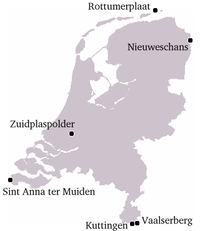
- Northernmost Point — RottumerplaatRottumerplaatRottumerplaat is one of the three islands that make up Rottum in the West Frisian Islands. The island is located in the North Sea off the Dutch coast. Access to the island is prohibited since Rottemerplaat is a resting and forage area for numerous bird species...
(53°33′18"N 6°28′41"E) - Northernmost Point (mainland) — near RoodeschoolRoodeschoolRoodeschool is a community situated in the northeast of Groningen province in the Netherlands and forming part of the municipality of Eemsmond...
(53°27′56"N 6°44′48"E) - Southernmost Point — boundary markerBoundary markerA boundary marker, boundary stone or border stone is a robust physical marker that identifies the start of a land boundary or the change in a boundary, especially a change in a direction of a boundary...
12, near Kuttingen, municipality of Gulpen-WittemGulpen-WittemGulpen-Wittem is a municipality in the southeastern Netherlands with 14.677 inhabitants as of 2008.Gulpen-Wittem came into being after the merger of the municipalities Gulpen and Wittem. This took place after a request of both municipalities. At the time of the merger, both municipalities had...
, LimburgLimburg (Netherlands)Limburg is the southernmost of the twelve provinces of the Netherlands. It is located in the southeastern part of the country and bordered by the province of Gelderland to the north, Germany to the east, Belgium to the south and part of the west, andthe Dutch province of North Brabant partly to...
(50°45′01.5"N 5°54′54.0"E) - Westernmost Point — Sint Anna ter MuidenSint Anna ter MuidenSint Anna ter Muiden is a village about 1 km west of Sluis, in the municipality of the same name. It is located on the westernmost point of the Netherlands, in the province of Zeeland. It has a population of 50 ....
(51°18′57"N 3°21′30"E) - Easternmost Point — Bad Nieuweschans (53°10′49"N 7°13′40"E)
- Highest Point — VaalserbergVaalserbergThe Vaalserberg is a hill 322.7 metres in height and the highest point in the European part of the Netherlands. The Vaalserberg is located in the province of Limburg, at the south-easternmost edge of the country in the municipality of Vaals, near the eponymous town, some three kilometres west of...
(322.7 m above sea level) (50°45′17"N 6°01′15"E) - Lowest point — ZuidplaspolderZuidplaspolderThe Zuidplaspolder is a polder in the Netherlands, containing the lowest point of Western Europe and in the entire European Union...
near Nieuwerkerk aan den IJsselNieuwerkerk aan den IJsselNieuwerkerk aan den IJssel is a town and former municipality in the western Netherlands, in the province of South Holland...
(6.76 m below sea level) (51°59′09"N 4°37′54"E)
Netherlands
When in the list above the special municipalitiesBES islands
The Caribbean Netherlands collectively refers to the three special municipalities of the Netherlands that are located overseas, in the Caribbean: Bonaire, Sint Eustatius and Saba...
in the Caribbean are included, the western- and southernmost points change to locations on the island Bonaire, whereas the highest point is on the island Saba. The approximate locations are:
- Westernmost Point — west of Lake Goto (12°17′2"N 68°24′52"W)
- Southernmost Point — Willemstoren Lighthouse Bonaire (12°1′26"N 68°14′52"W)
- Highest Point — Mount SceneryMount SceneryMount Scenery is a potentially active volcano in the Caribbean Netherlands. Its lava dome forms the summit of the Saba island stratovolcano. At an elevation of 877 m, it is the highest point in both the Kingdom of the Netherlands, and, since the dissolution of the Netherlands Antilles on 10...
(877 m above sea level) (17°38′06"N 63°14′21"W)
Kingdom of the Netherlands
When all countries of the Kingdom of the NetherlandsKingdom of the Netherlands
The Kingdom of the Netherlands is a sovereign state and constitutional monarchy with territory in Western Europe and in the Caribbean. The four parts of the Kingdom—Aruba, Curaçao, the Netherlands, and Sint Maarten—are referred to as "countries", and participate on a basis of equality...
are taken into account, the Westermost point moves to Aruba
Aruba
Aruba is a 33 km-long island of the Lesser Antilles in the southern Caribbean Sea, located 27 km north of the coast of Venezuela and 130 km east of Guajira Peninsula...
.
- Westernmost Point — Divi village, ArubaArubaAruba is a 33 km-long island of the Lesser Antilles in the southern Caribbean Sea, located 27 km north of the coast of Venezuela and 130 km east of Guajira Peninsula...
(12°32′24"N 70°3′48"W)