

Geography of Serbia
Encyclopedia
Serbia
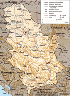
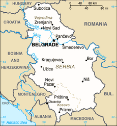
Serbia , officially the Republic of Serbia , is a landlocked country located at the crossroads of Central and Southeast Europe, covering the southern part of the Carpathian basin and the central part of the Balkans...
is country located in the Balkans
Balkans
The Balkans is a geopolitical and cultural region of southeastern Europe...
(a historical and geographical region of southeastern Europe
Europe
Europe is, by convention, one of the world's seven continents. Comprising the westernmost peninsula of Eurasia, Europe is generally 'divided' from Asia to its east by the watershed divides of the Ural and Caucasus Mountains, the Ural River, the Caspian and Black Seas, and the waterways connecting...
) and in the Pannonian Plain (a region of central Europe). It shares borders with Bosnia-Herzegovina, Bulgaria
Bulgaria
Bulgaria , officially the Republic of Bulgaria , is a parliamentary democracy within a unitary constitutional republic in Southeast Europe. The country borders Romania to the north, Serbia and Macedonia to the west, Greece and Turkey to the south, as well as the Black Sea to the east...
, Croatia
Croatia
Croatia , officially the Republic of Croatia , is a unitary democratic parliamentary republic in Europe at the crossroads of the Mitteleuropa, the Balkans, and the Mediterranean. Its capital and largest city is Zagreb. The country is divided into 20 counties and the city of Zagreb. Croatia covers ...
, Hungary
Hungary
Hungary , officially the Republic of Hungary , is a landlocked country in Central Europe. It is situated in the Carpathian Basin and is bordered by Slovakia to the north, Ukraine and Romania to the east, Serbia and Croatia to the south, Slovenia to the southwest and Austria to the west. The...
, the Republic of Macedonia
Republic of Macedonia
Macedonia , officially the Republic of Macedonia , is a country located in the central Balkan peninsula in Southeast Europe. It is one of the successor states of the former Yugoslavia, from which it declared independence in 1991...
, Montenegro
Montenegro
Montenegro Montenegrin: Crna Gora Црна Гора , meaning "Black Mountain") is a country located in Southeastern Europe. It has a coast on the Adriatic Sea to the south-west and is bordered by Croatia to the west, Bosnia and Herzegovina to the northwest, Serbia to the northeast and Albania to the...
, and Romania
Romania
Romania is a country located at the crossroads of Central and Southeastern Europe, on the Lower Danube, within and outside the Carpathian arch, bordering on the Black Sea...
. Serbia claims a border with Albania
Albania
Albania , officially known as the Republic of Albania , is a country in Southeastern Europe, in the Balkans region. It is bordered by Montenegro to the northwest, Kosovo to the northeast, the Republic of Macedonia to the east and Greece to the south and southeast. It has a coast on the Adriatic Sea...
as well through its disputed territory of Kosovo
Kosovo
Kosovo is a region in southeastern Europe. Part of the Ottoman Empire for more than five centuries, later the Autonomous Province of Kosovo and Metohija within Serbia...
. It is landlocked
Landlocked
A landlocked country is a country entirely enclosed by land, or whose only coastlines lie on closed seas. There are 48 landlocked countries in the world, including partially recognized states...
, although access to the Adriatic is available through Montenegro
Montenegro
Montenegro Montenegrin: Crna Gora Црна Гора , meaning "Black Mountain") is a country located in Southeastern Europe. It has a coast on the Adriatic Sea to the south-west and is bordered by Croatia to the west, Bosnia and Herzegovina to the northwest, Serbia to the northeast and Albania to the...
, and the Danube River provides shipping access to inland Europe and the Black Sea
Black Sea
The Black Sea is bounded by Europe, Anatolia and the Caucasus and is ultimately connected to the Atlantic Ocean via the Mediterranean and the Aegean seas and various straits. The Bosphorus strait connects it to the Sea of Marmara, and the strait of the Dardanelles connects that sea to the Aegean...
.
General geographical information
Serbia covers a total of 88,361 km², which places it at 113th place in the world. Its total border length amounts to 2,027 km (Albania 115 km, Bosnia and Herzegovina 302 km, Bulgaria 318 km, Croatia 241 km, Hungary 151 km, Macedonia 221 km, Montenegro 203 km and Romania 476 km). All of Serbia's border with Albania, and parts of the borders with Macedonia, Montenegro, are under control of the United Nations Mission in Kosovo. It has 6,167 registered settlements, 207 urban and 5960 others (rural).Arable land
Arable land
In geography and agriculture, arable land is land that can be used for growing crops. It includes all land under temporary crops , temporary meadows for mowing or pasture, land under market and kitchen gardens and land temporarily fallow...
covers 19,194 km², and woods
Woodland
Ecologically, a woodland is a low-density forest forming open habitats with plenty of sunlight and limited shade. Woodlands may support an understory of shrubs and herbaceous plants including grasses. Woodland may form a transition to shrubland under drier conditions or during early stages of...
cover 19,499 km² of the territory of Serbia without Kosovo.
Extreme points:
- North: 46°11'N (near HajdukovoHajdukovoHajdukovo is a village located in the Subotica municipality, in the North Bačka District of Serbia. It is situated in the autonomous province of Vojvodina. The village has a Hungarian ethnic majority and its population numbering 2,482 people .-External links:*...
) - South: 41°52' N (near PrizrenPrizrenPrizren is a historical city located in southern Kosovo. It is the administrative center of the eponymous municipality and district.The city has a population of around 131,247 , mostly Albanians...
) - East: 23°01'E (Senokos near DimitrovgradDimitrovgrad, SerbiaDimitrovgrad is a town and 483 km² large municipality located in the Pirot District of the Republic of Serbia. According to 2011 census, the municipality of Dimitrovgrad has a population of 10,056 people and the town 6,247.-Name:...
) - West: 18°51'E (near BezdanBezdanBezdan is a village located in Bačka, Vojvodina, Serbia. It is situated in the Sombor municipality, West Bačka District...
in Vojvodina)
Terrain
Serbia's terrain ranges from rich, fertile plains of the northern VojvodinaVojvodina
Vojvodina, officially called Autonomous Province of Vojvodina is an autonomous province of Serbia. Its capital and largest city is Novi Sad...
region, limestone ranges and basins in the east, and in the southeast ancient mountains and hills. The north is dominated by the Danube River. A tributary, the Morava River flows through the more mountainous southern regions.
In Central Serbia
Central Serbia
Central Serbia , also referred to as Serbia proper , was the region of Serbia from 1945 to 2009. It included central parts of Serbia outside of the autonomous provinces of Kosovo and Vojvodina. The region of Central Serbia was not an administrative division of Serbia as such; it was under the...
, the terrain consists chiefly of hills, low and medium-high mountains, interspersed with numerous rivers and creeks. The main communication and development line stretches southeast of Belgrade, towards Niš
Niš
Niš is the largest city of southern Serbia and third-largest city in Serbia . According to the data from 2011, the city of Niš has a population of 177,972 inhabitants, while the city municipality has a population of 257,867. The city covers an area of about 597 km2, including the urban area,...
and Skopje
Skopje
Skopje is the capital and largest city of the Republic of Macedonia with about a third of the total population. It is the country's political, cultural, economic, and academic centre...
(in Republic of Macedonia
Republic of Macedonia
Macedonia , officially the Republic of Macedonia , is a country located in the central Balkan peninsula in Southeast Europe. It is one of the successor states of the former Yugoslavia, from which it declared independence in 1991...
), along the valley of Great and South Morava river. Most major cities are located on or around that line, as well as the main railroad and highway
European route E75
European route E 75 is part of the International E-road network, which is a series of main roads in Europe.The E 75 starts from Vardø, Norway in the Barents Sea and runs south through Finland, Poland, Czech Republic, Slovakia, Hungary, Serbia and Republic of Macedonia to Sitia, Greece on...
. On the East of it, the terrain quickly rises to limestone ranges of Stara Planina and Serbian Carpathians
Serbian Carpathians
Serbian Carpathians is a mountain range in eastern Central Serbia. It presents an extension of proper Carpathian Mountains across the Danube, connecting them with the Balkan Mountains in the southeast. They stretch in north-south direction in the eastern Serbia, west of the Great Morava valley and...
, relatively sparsely populated. On the West, height of mountains slowly rises towards southwest, but they do not form real ridge
Ridge
A ridge is a geological feature consisting of a chain of mountains or hills that form a continuous elevated crest for some distance. Ridges are usually termed hills or mountains as well, depending on size. There are several main types of ridges:...
s. The highest mountains of that area are Zlatibor
Zlatibor
Zlatibor is a mountain region situated in the western part of Serbia, a part of the Dinaric Alps.The mountain range spreads over an area of 300 km², 27 miles in length, southeast to northwest, and up to 23 miles in width. The highest peak is Tornik at 1496 m...
and Kopaonik
Kopaonik
Kopaonik ; is one of the larger mountain ranges of Serbia. It is located in the central part of Serbia, while a small portion extendeds to North Kosovo. Its highest point, Pančić's Peak, is above sea level....
.
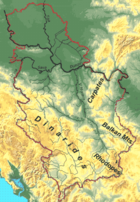
Mountains
Dinaric Alps
The Dinaric Alps or Dinarides form a mountain chain in Southern Europe, spanning areas of Slovenia, Croatia, Bosnia and Herzegovina, Serbia, Kosovo, Albania and Montenegro....
in the west cover the greatest territory, and stretch from northwest to southeast. Carpathian Mountains
Carpathian Mountains
The Carpathian Mountains or Carpathians are a range of mountains forming an arc roughly long across Central and Eastern Europe, making them the second-longest mountain range in Europe...
and Balkan Mountains
Balkan Mountains
The Balkan mountain range is a mountain range in the eastern part of the Balkan Peninsula. The Balkan range runs 560 km from the Vrashka Chuka Peak on the border between Bulgaria and eastern Serbia eastward through central Bulgaria to Cape Emine on the Black Sea...
stretch in north-south direction in the eastern Serbia, west of the Morava valley. Ancient mountains along the South Morava belong to Rilo-Rhodope Mountain system.
The most significant mountains in Serbia are:
- DivčibareDivcibareDivčibare is a mountain resort situated on the mountain Maljen in western Serbia, south-east of Valjevo, at the altitude of 980 metres above sea level...
- TaraTara MountainTara , is a mountain located in western Serbia. It is part of Dinaric Alps and stands at 1,000-1,500 metres above sea level. The mountain's slopes are clad in dense forests with numerous high-altitude clearings and meadows, steep cliffs, deep ravines carved by the nearby Drina River and many karst,...
- ZlatiborZlatiborZlatibor is a mountain region situated in the western part of Serbia, a part of the Dinaric Alps.The mountain range spreads over an area of 300 km², 27 miles in length, southeast to northwest, and up to 23 miles in width. The highest peak is Tornik at 1496 m...
- KopaonikKopaonikKopaonik ; is one of the larger mountain ranges of Serbia. It is located in the central part of Serbia, while a small portion extendeds to North Kosovo. Its highest point, Pančić's Peak, is above sea level....
- BrezovicaBrezovicaBrezovica or Brezovitsa may refer to:* Brezovica Municipality, Slovenia* Brezovica, Hrpelje – Kozina Slovenia* Brezovica, Radovljica Slovenia* Brezovica, Velika Polana in Slovenia* Brezovica, Sabinov, a village in Sabinov District in Slovakia...
- Fruška GoraFruška GoraFruška Gora is a mountain in north Syrmia. Most part of the territory is located within Vojvodina, Serbia, but a smaller part on its western side overlaps the territory of Croatia...
The highest peak in Serbia is Đeravica on Prokletije
Prokletije
Prokletije or Albanian Alps is a mountain range in the Balkans that extends from northern Albania, to southwestern Serbia and eastern Montenegro. Its highest point, Jezercë in Albania at , is the tallest peak in the entire Dinaric Alps...
(2,656 m) in Kosovo
Kosovo
Kosovo is a region in southeastern Europe. Part of the Ottoman Empire for more than five centuries, later the Autonomous Province of Kosovo and Metohija within Serbia...
.
Hydrology
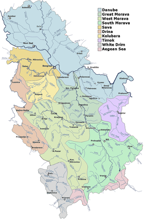
Danube
The Danube is a river in the Central Europe and the Europe's second longest river after the Volga. It is classified as an international waterway....
(Black Sea
Black Sea
The Black Sea is bounded by Europe, Anatolia and the Caucasus and is ultimately connected to the Atlantic Ocean via the Mediterranean and the Aegean seas and various straits. The Bosphorus strait connects it to the Sea of Marmara, and the strait of the Dardanelles connects that sea to the Aegean...
) drainage basin
Drainage basin
A drainage basin is an extent or an area of land where surface water from rain and melting snow or ice converges to a single point, usually the exit of the basin, where the waters join another waterbody, such as a river, lake, reservoir, estuary, wetland, sea, or ocean...
, an area in Kosovo (5%) belongs to the Adriatic drainage basin, chiefly through the White Drin river, and the rest (3%) in Kosovo and southern Serbia belongs to Aegean
Aegean Sea
The Aegean Sea[p] is an elongated embayment of the Mediterranean Sea located between the southern Balkan and Anatolian peninsulas, i.e., between the mainlands of Greece and Turkey. In the north, it is connected to the Marmara Sea and Black Sea by the Dardanelles and Bosporus...
basin, chiefly via the Vardar
Vardar
The Vardar or Axios is the longest and major river in the Republic of Macedonia and also a major river of Greece. It is long, and drains an area of around . The maximum depth of river is ....
river.
Apart from the Danube, which flows 588 km through Serbia or as a border river (with Croatia
Croatia
Croatia , officially the Republic of Croatia , is a unitary democratic parliamentary republic in Europe at the crossroads of the Mitteleuropa, the Balkans, and the Mediterranean. Its capital and largest city is Zagreb. The country is divided into 20 counties and the city of Zagreb. Croatia covers ...
on its northwestern flow and Romania
Romania
Romania is a country located at the crossroads of Central and Southeastern Europe, on the Lower Danube, within and outside the Carpathian arch, bordering on the Black Sea...
on southeast), the chief rivers are its tributaries Sava (incoming from West), Tisa
Tisá
Tisá is a village and municipality in Ústí nad Labem District in the Ústí nad Labem Region of the Czech Republic.The municipality covers an area of , and has a population of 786 ....
(incoming from North), Drina
Drina
The Drina is a 346 kilometer long river, which forms most of the border between Bosnia and Herzegovina and Serbia. It is the longest tributary of the Sava River and the longest karst river in the Dinaric Alps which belongs to the Danube river watershed...
(incoming from South, forming a natural border
Natural border
A natural border is a border between states which is composed of natural formations such as rivers, mountain ranges, or deserts.Having a natural border is strategically very useful, as invading armies can have a hard time crossing such a border...
with Bosnia and Herzegovina
Bosnia and Herzegovina
Bosnia and Herzegovina , sometimes called Bosnia-Herzegovina or simply Bosnia, is a country in Southern Europe, on the Balkan Peninsula. Bordered by Croatia to the north, west and south, Serbia to the east, and Montenegro to the southeast, Bosnia and Herzegovina is almost landlocked, except for the...
) and Morava
Velika Morava
The Great Morava is the final section of the Morava , a major river system in Serbia.- Length :...
; only the latter flowing (almost) entirely through Serbia. Their tributaries form a dense network of smaller rivers and creeks, covering most of the country.
Due to the configuration of the terrain, natural lake
Lake
A lake is a body of relatively still fresh or salt water of considerable size, localized in a basin, that is surrounded by land. Lakes are inland and not part of the ocean and therefore are distinct from lagoons, and are larger and deeper than ponds. Lakes can be contrasted with rivers or streams,...
s are sparse and small; most of them are located in Vojvodina
Vojvodina
Vojvodina, officially called Autonomous Province of Vojvodina is an autonomous province of Serbia. Its capital and largest city is Novi Sad...
, like the glacial lake
Glacial lake
A glacial lake is a lake with origins in a melted glacier. Near the end of the last glacial period, roughly 10,000 years ago, glaciers began to retreat. A retreating glacier often left behind large deposits of ice in hollows between drumlins or hills. As the ice age ended, these melted to create...
Palić
Palic Lake
The Palić lake is a lake situated from Subotica, near the town of Palić, in Serbia. It covers an area of . The average depth of the lake is .-History and development:...
or numerous oxbow lake
Oxbow lake
An oxbow lake is a U-shaped body of water formed when a wide meander from the main stem of a river is cut off to create a lake. This landform is called an oxbow lake for the distinctive curved shape, named after part of a yoke for oxen. In Australia, an oxbow lake is called a billabong, derived...
s along river flows. However, there are numerous artificial lakes, mostly due to hydroelectric dams, the biggest being Đerdap on the Danube, Perućac
Perucac
Perućac is a village in western Serbia in the immediate proximity of the border with Bosnia and Herzegovina. It is situated near the 346 km-long Drina River, which constitutes the natural border between Serbia and Bosnia....
on the Drina and Vlasina Lake
Vlasina Lake
Vlasina Lake is a semi-artificial lake in Southeast Serbia. Lying at the altitude of 1211 m, with the area of 16 km², it is the highest and largest artificial lake in Serbia...
.
Abundance of relatively unpolluted surface waters and numerous underground natural and mineral water sources of high water quality
Water quality
Water quality is the physical, chemical and biological characteristics of water. It is a measure of the condition of water relative to the requirements of one or more biotic species and or to any human need or purpose. It is most frequently used by reference to a set of standards against which...
presents a chance for export and economy improvement; however, more extensive exploitation and production of bottled water began only recently. Despite this, many Serbian cities still suffer from water supply problems, due to mismanagement and low investments in the past, as well as water pollution (like the pollution of the Ibar River
Ibar River
The Ibar is a river that flows through eastern Montenegro and Serbia, with a total length of . The river begins in the Hajla mountain, eastern Montenegro, passes through Kosovo and flows into the West Morava river, Central Serbia, near Kraljevo....
from the Trepča
Trepça
- Basketball Hall :The club currently plays in the sport and youth center "Palestra e Sporteve Minatori", in the center of Mitrovica, with a capacity for around 3500 spectators.- Roster :-Notable players:- External links :**...
zinc
Zinc
Zinc , or spelter , is a metallic chemical element; it has the symbol Zn and atomic number 30. It is the first element in group 12 of the periodic table. Zinc is, in some respects, chemically similar to magnesium, because its ion is of similar size and its only common oxidation state is +2...
-lead
Lead
Lead is a main-group element in the carbon group with the symbol Pb and atomic number 82. Lead is a soft, malleable poor metal. It is also counted as one of the heavy metals. Metallic lead has a bluish-white color after being freshly cut, but it soon tarnishes to a dull grayish color when exposed...
combinate, affecting the city of Kraljevo
Kraljevo
Kraljevo is a city and municipality in central Serbia, built beside the river Ibar, 7 km west of its confluence with the Western Morava. It is located in the midst of an upland valley, between the mountains of Kotlenik in the north, and Stolovi in the south.In 2011 the city has population of...
, or the presence of natural arsenic
Arsenic
Arsenic is a chemical element with the symbol As, atomic number 33 and relative atomic mass 74.92. Arsenic occurs in many minerals, usually in conjunction with sulfur and metals, and also as a pure elemental crystal. It was first documented by Albertus Magnus in 1250.Arsenic is a metalloid...
in underground waters in Zrenjanin
Zrenjanin
Zrenjanin is a city and municipality located in the eastern part of Serbian province of Vojvodina. It is the administrative centre of the Central Banat District of Serbia...
).
The hydroenergetic potential of Serbia is around 17,000 GWh, of which around 10,000 GWh (60%) is utilized in power plants, chiefly big ones. The remaining unused potential can be realized using small and medium power plants (<25 MW), whose building by the private sector is seen as a chance for improvement of Serbia's economy and energy reliability.
Serbia also has a huge geothermal potential, which is only partially and sporadically utilized. The use of geothermal waters is chiefly for balneological purposes: there are around 60 spa
Spa
The term spa is associated with water treatment which is also known as balneotherapy. Spa towns or spa resorts typically offer various health treatments. The belief in the curative powers of mineral waters goes back to prehistoric times. Such practices have been popular worldwide, but are...
s, which are seen as a great chance for improvement of the tourism
Tourism
Tourism is travel for recreational, leisure or business purposes. The World Tourism Organization defines tourists as people "traveling to and staying in places outside their usual environment for not more than one consecutive year for leisure, business and other purposes".Tourism has become a...
sector.
Climate
Climate of Serbia is moderate continentalContinental climate
Continental climate is a climate characterized by important annual variation in temperature due to the lack of significant bodies of water nearby...
with a diversity on local level, caused by geographic location, relief, terrain exposition, presence of river and lake systems, vegetation, urbanization etc. Proximity of the mountain ranges of Alps
Alps
The Alps is one of the great mountain range systems of Europe, stretching from Austria and Slovenia in the east through Italy, Switzerland, Liechtenstein and Germany to France in the west....
, Carpathians
Carpathian Mountains
The Carpathian Mountains or Carpathians are a range of mountains forming an arc roughly long across Central and Eastern Europe, making them the second-longest mountain range in Europe...
, Rhodopes, as well as Adriatic Sea
Adriatic Sea
The Adriatic Sea is a body of water separating the Italian Peninsula from the Balkan peninsula, and the system of the Apennine Mountains from that of the Dinaric Alps and adjacent ranges...
and Pannonian plain affect the climate. Location of river ravines and plains in the northern area of the country enable occasional deep southward protrusion of polar air masses on winters, while hot Sahara
Sahara
The Sahara is the world's second largest desert, after Antarctica. At over , it covers most of Northern Africa, making it almost as large as Europe or the United States. The Sahara stretches from the Red Sea, including parts of the Mediterranean coasts, to the outskirts of the Atlantic Ocean...
n air often intrudes over the Mediterranean Sea
Mediterranean Sea
The Mediterranean Sea is a sea connected to the Atlantic Ocean surrounded by the Mediterranean region and almost completely enclosed by land: on the north by Anatolia and Europe, on the south by North Africa, and on the east by the Levant...
on summers.
Average annual air temperature for the period 1961-1990 for the area with the altitude of up to 300 m amounts to 11 °C (51.8 °F). The areas with the altitudes of 300 to 500 m (984.3 to 1,640.4 ft) have average annual temperature of around 10.5 °C (50.9 °F), and over 1000 m (3,281 ft) of altitude around 6 °C (42.8 °F).
Annual precipitation
Precipitation (meteorology)
In meteorology, precipitation In meteorology, precipitation In meteorology, precipitation (also known as one of the classes of hydrometeors, which are atmospheric water phenomena is any product of the condensation of atmospheric water vapor that falls under gravity. The main forms of precipitation...
, generally, rises with altitude
Altitude
Altitude or height is defined based on the context in which it is used . As a general definition, altitude is a distance measurement, usually in the vertical or "up" direction, between a reference datum and a point or object. The reference datum also often varies according to the context...
. In lower regions, it ranges in the interval from 540 to 820 mm (21.3 to 32.3 in), areas on altitude over 1000 m (3,281 ft) receive in average 700 to 1000 mm (27.6 to 39.4 in), and some mountainous summits in southwestern Serbia up to 1500 mm (59.1 in). Major part of Serbia has continental precipitation regimen, with peak in the earlier summer period, except for southwest, which receives highest precipitation autumn. May–June is the rainiest month, with the average of 12 to 13% of total annual amount. February and October have the least precipitation. Snow cover can occurs from late November to early March, and majority of days with snow cover is in January.
Annual sums of solar radiation are in the interval from 1 500 to 2 200 hours annually.
Surface air circulation is largely influenced by orographic lift
Orographic lift
Orographic lift occurs when an air mass is forced from a low elevation to a higher elevation as it moves over rising terrain. As the air mass gains altitude it quickly cools down adiabatically, which can raise the relative humidity to 100% and create clouds and, under the right conditions,...
. In warmer part of the year, winds from northwest and west prevail. In Vojvodina and Sumadija, east-southeast wind, Košava
Košava (wind)
Košava is a cold, very squally southeastern wind found in Serbia and some nearby countries. It starts in the Carpathian Mountains and follows the Danube northwest through the Iron Gate region where it gains a jet effect, then continues to Belgrade. It can spread as far north as Hungary and as...
, dominates over autumn and winter. Southwestern winds prevail in mountainous part of southwestern Serbia.
Nature preservation areas and parks
Serbia has four national parkNational park
A national park is a reserve of natural, semi-natural, or developed land that a sovereign state declares or owns. Although individual nations designate their own national parks differently A national park is a reserve of natural, semi-natural, or developed land that a sovereign state declares or...
s and many national nature reserves encompassing 5% of the territory.
National parks:
- Fruška GoraFruška GoraFruška Gora is a mountain in north Syrmia. Most part of the territory is located within Vojvodina, Serbia, but a smaller part on its western side overlaps the territory of Croatia...
(250 km²) - KopaonikKopaonikKopaonik ; is one of the larger mountain ranges of Serbia. It is located in the central part of Serbia, while a small portion extendeds to North Kosovo. Its highest point, Pančić's Peak, is above sea level....
(120 km²) - Tara (220 km²)
- Đerdap (Iron GateIron Gate (Danube)The Iron Gates The gorge lies between Romania in the north and Serbia in the south. At this point, the river separates the southern Carpathian Mountains from the northwestern foothills of the Balkan Mountains. The Romanian, Hungarian, Slovakian, Turkish, German and Bulgarian names literally mean...
) (640 km²)
Nature parks:
- ProkletijeProkletijeProkletije or Albanian Alps is a mountain range in the Balkans that extends from northern Albania, to southwestern Serbia and eastern Montenegro. Its highest point, Jezercë in Albania at , is the tallest peak in the entire Dinaric Alps...
(1000 km²) - Gornje PodunavljeGornje podunavljethumb|right|400pxGornje Podunavlje Special Nature Reserve is a large protected area of wetland in the northwest of Serbia...
(100 km²) - Stara Planina (1420 km²)
- GolijaGolijaGolija is a mountain in southwestern Serbia, between towns of Ivanjica and Novi Pazar. It belongs to the Dinaric mountain range. The mountain is heavily forested, with significant biodiversity and it hosts the Golija-Studenica Biosphere Reserve, the first UNESCO-MAB registered biosphere reserve in...
(750 km²) - Kučajske planineKučajske planineKučaj mountains is a mountain range in eastern Serbia. Its highest peak, Velika Tresta has an altitude of 1284 metres above sea level. They belong to Serbian extension of Carpathians...
(1150 km²)
Special nature reservations:
- Deliblato Sands (300 km²)
- Ludaš LakeLudaš LakeLudaš or Ludoš Lake is a shallow lake in the province of Vojvodina in northern Serbia, near Subotica. It is a special natural preserve and, since 1977, designated as a swamp area of international significance by the Ramsar Convention...
(5.93 km²) - Obedska PondObedska PondObedska bara is a large swamp-forest area and natural reserve stretching along the Sava River in Southern Syrmia , some 40 km west of Belgrade....
(175.01 km²) - Stari Begej – Carska Bara (17.67 km²)
Nature monuments:
- Đavolja Varoš (0.64 km²)
See also
- Geography of EuropeGeography of EuropeEurope is traditionally reckoned as one of seven continents. Physiographically, however, it is the northwestern peninsula of the larger landmass known as Eurasia : Asia occupies the eastern bulk of this continuous landmass and all share a common continental shelf...
- Geography of VojvodinaGeography of VojvodinaVojvodina is an autonomous region within Serbia located in the Pannonian plain, a region of central Europe. It shares borders with Romania in the east, Hungary in the north, Croatia in the west, and Bosnia and Herzegovina in the southwest...
- Regions of Serbia
- Geology of SerbiaGeology of SerbiaThe geology of Serbia is complex for a relatively small country. In a tectonic sense, Serbia is part of the Alpine orogenic belt of Southeastern Europe...