
Velika Morava
Encyclopedia
The Great Morava is the final section of the Morava (Cyrillic: Морава), a major river system in Serbia
.
, a major railway junction in central Serbia. From there to its confluence with the Danube
northeast of the city of Smederevo
, the Velika Morava is 185 km long. With its longer branch, the West Morava, it is 493 km long. The South Morava, which represent the natural headwaters of the Morava, used to be longer than the West Morava, but due to the regulations of river bed and melioration, today it is shorter. Regulations were made on all three branches, and they all used to be much longer, so the Morava was over 600 km long. Today, the most distant water source in the Morava watershed is the source of the river Ibar
, right and longest tributary of the Zapadna Morava, originating in Montenegro
, which gives the Ibar-West Morava-Great Morava river system a length of 550 km, which still makes it the longest waterway in the Balkan Peninsula.
. Pomoravlje actually was formed in a fossil bay of a vast, ancient Pannonian Sea
which dried out 200,000 years ago. On about half of its length it passes through beautiful Bagrdan gorge (Bagrdanska klisura). In past centuries, it was known for its seemingly endless forests, but there is almost nothing left today of those big old woods. It flows into the Danube between villages of Kulič & Dubravica, in a big coal mining basin of Kostolac
, one of two major in its drainage basin, other one being Resava coal basin, in valley of the Velika Morava's right tributary Resava
. Average discharge of Velika Morava on its confluence with Danube is 255 m³/s (120 m³/s brought by Zapadna Morava, 100 m³/s by Južna Morava, and 35 m³/s amounted by Velika Morava itself).
and Resavica
(or Resavčina). Left tributaries are more numerous, including: Kalenićka reka, Lugomir
, Belica River
, Lepenica
, Rača, and Jasenica
. Many of them don't carry much water, but in rainy years, they are known for causing major floods, which is the big problem of the whole Morava river system. Before it meets Danube, Velika Morava splits, creating 47 km long arm called Jezava, which flows into the Danube separately, in the town of Smederevo, and it's joined by longer (51 km) river Ralja
, from the left.
The river bed is 80–200 m wide, and the depth as much as 10 m. Notorious for its flooding, the Morava has changed its course many times, and old river bends have become small lakes, known as moravište. Južna Morava, with extremely high erosion in its drainage basin, brings huge amounts of materials which are elevating Velika Morava's river bed, making floods even more frequent.
Beginning in 1966, huge works began on all three rivers to prevent future floodings. Series of reservoirs were made on tributaries (lakes Bovan, Ćelije, Gazivode, etc.), and meanders were cut through, making river courses straightened, which made them shorter (in case of Velika Morava, from 245 to 185 km). It was projected that it will shorten by as much as 152 km, and that it will become navigable again.
Altogether, 18 reservoirs are projected, 23 meanders are to be cut, a series of embankments built and intensive afforestation started. However, since the late 1980s and especially since the 1990s, with economic crises and wars in former Yugoslavia, this all stopped.
The Morava and its tributaries still flood often, so its bed still is elevated, despite dozens of gravel-digging companies in cities and villages near the river's upper course (Lozovik
, Lugavčina
, Lučica
, Velika Plana
, etc.).
 Today, Velika Morava is navigable for only 3 km from its mouth. In the past it was navigable all the way to the city of Ćuprija
, for about 3/4 of its length. But, as mentioned before, Velika Morava literally gets buried under the materials brought by Južna Morava. When melioration program began in 1966, it was projected it would become navigable again, in the first phase to Ćuprija
, and in the next all the way to Stalać
, making it 100% navigable. Even at that time this didn't seem very likely and was probably nothing but a wishful thinking of some local politician, which was common during the Communist period. None of it has been accomplished. From time to time, the idea of digging Danube
-Morava-Vardar
-Aegean Sea
* http://www.danube-cooperation.com/library/93jovanovski.htm navigable canal pops up in the media. Technical problems of making this waterway would be enormous (neither Morava or Vardar are navigable), it is not sure how much it would be used, and presumably it would cost (4.4 billion dolars) way too much, so it remains mostly as a sort of popular curiosity.
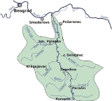
, Jagodina
, Batočina
, Lapovo
, Svilajnac
, Velika Plana
, Požarevac
and Smederevo
. Smaller places and villages include: Varvarin
, Glogovac, Markovac, Veliko Orašje, Miloševac and Lozovik
.
), etc. Oj Moravo may be the most characteristic:
Serbia
Serbia , officially the Republic of Serbia , is a landlocked country located at the crossroads of Central and Southeast Europe, covering the southern part of the Carpathian basin and the central part of the Balkans...
.
Length
The Velika (Great) Morava is created by the confluence of the South Morava and the West Morava, located near the small town of StalaćStalać
Stalać is a village in the municipality of Ćićevac, western Serbia. According to the 2002 census, the village has a population of 1828 people.Stalać lies at the banks of South Morava, near its confluence with West Morava into Great Morava...
, a major railway junction in central Serbia. From there to its confluence with the Danube
Danube
The Danube is a river in the Central Europe and the Europe's second longest river after the Volga. It is classified as an international waterway....
northeast of the city of Smederevo
Smederevo
Smederevo is a city and municipality in Serbia, on the right bank of the Danube, about 40 km downstream of the capital Belgrade. According to official results of the 2011 census, the city has a population of 107,528...
, the Velika Morava is 185 km long. With its longer branch, the West Morava, it is 493 km long. The South Morava, which represent the natural headwaters of the Morava, used to be longer than the West Morava, but due to the regulations of river bed and melioration, today it is shorter. Regulations were made on all three branches, and they all used to be much longer, so the Morava was over 600 km long. Today, the most distant water source in the Morava watershed is the source of the river Ibar
Ibar River
The Ibar is a river that flows through eastern Montenegro and Serbia, with a total length of . The river begins in the Hajla mountain, eastern Montenegro, passes through Kosovo and flows into the West Morava river, Central Serbia, near Kraljevo....
, right and longest tributary of the Zapadna Morava, originating in Montenegro
Montenegro
Montenegro Montenegrin: Crna Gora Црна Гора , meaning "Black Mountain") is a country located in Southeastern Europe. It has a coast on the Adriatic Sea to the south-west and is bordered by Croatia to the west, Bosnia and Herzegovina to the northwest, Serbia to the northeast and Albania to the...
, which gives the Ibar-West Morava-Great Morava river system a length of 550 km, which still makes it the longest waterway in the Balkan Peninsula.
Geography
The area of drainage basin of Velika Morava is 6,126 km², and of whole Morava system 37,444 km² (of that, 1,237 km² in Bulgaria and 44 km² in Macedonia), which covers 42,38% of Serbia. Velika Morava flows through the most fertile and densely populated area of Central Serbia, called Morava river valley, or PomoravljePomoravlje
Pomoravlje may refer to:* Pomoravlje , a geographical area around the Morava river, Serbia* Pomoravlje District, a district in Serbia...
. Pomoravlje actually was formed in a fossil bay of a vast, ancient Pannonian Sea
Pannonian Sea
The Pannonian Sea was a shallow ancient sea located in the area today known as the Pannonian Plain in Central Europe. The Pannonian Sea existed during the Miocene and Pliocene epochs, when three to four kilometres of marine sediments were deposited in the Pannonian Basin.-History:The Pannonian Sea...
which dried out 200,000 years ago. On about half of its length it passes through beautiful Bagrdan gorge (Bagrdanska klisura). In past centuries, it was known for its seemingly endless forests, but there is almost nothing left today of those big old woods. It flows into the Danube between villages of Kulič & Dubravica, in a big coal mining basin of Kostolac
Kostolac
Kostolac is a small Serbian town on the Danube river in the Braničevo District. The remains of the Roman capital of the province of Moesia Superior Viminacium are located near Stari Kostolac some 2 km to the east of Kostolac. Kostolac is situated in the municipality of Požarevac...
, one of two major in its drainage basin, other one being Resava coal basin, in valley of the Velika Morava's right tributary Resava
Resava
Resava refers to several toponyms and related topics, all of them located around the river Resava in central Serbia:* Resava , a river* Resava, a region, surrounding the river* Resava, a monastery...
. Average discharge of Velika Morava on its confluence with Danube is 255 m³/s (120 m³/s brought by Zapadna Morava, 100 m³/s by Južna Morava, and 35 m³/s amounted by Velika Morava itself).
Tributaries
Tributaries of the Velika Morava are short in length, longest one being the Jasenica (79 km) and others rarely exceeding 50 km. Right tributaries are: Jovanovačka reka, Crnica, Ravanica, ResavaResava
Resava refers to several toponyms and related topics, all of them located around the river Resava in central Serbia:* Resava , a river* Resava, a region, surrounding the river* Resava, a monastery...
and Resavica
Resavica
Resavica may refer to:* Resavica River , a river in Serbia, tributary to the Resava River* Resavica River , or Resavčina, river in Serbia, tributary to the Velika Morava* Resavica , a town in Serbia...
(or Resavčina). Left tributaries are more numerous, including: Kalenićka reka, Lugomir
Lugomir
The Lugomir is a river in central Serbia, a 57 km-long right tributary to the Velika Morava river.- Origin :The Lugomir originates from two headstreams, the Dulenska rekaand the Županjevačka reka....
, Belica River
Belica River
The Belica is a left tributary of the Great Morava in Central Serbia. It is created by the confluence of smaller rivers Voljavica and Bešnjaja, floes through a deforested valley to the town Jagodina.- References :...
, Lepenica
Lepenica
Lepenica may refer to:*Lepenica , in Serbia*Lepenica *Lepenica, Pčinja*Lepenica, Mačva...
, Rača, and Jasenica
Jasenica
The Jasenica is a river is central Serbia. It's 79 km long left tributary of the Velika Morava and gives the name to the Jasenica region.- River :...
. Many of them don't carry much water, but in rainy years, they are known for causing major floods, which is the big problem of the whole Morava river system. Before it meets Danube, Velika Morava splits, creating 47 km long arm called Jezava, which flows into the Danube separately, in the town of Smederevo, and it's joined by longer (51 km) river Ralja
Ralja
The Ralja is a river in Šumadija region of Serbia, a 51 km-long left tributary to the Jezava, the left arm of the Velika Morava river...
, from the left.
Improvements
The Velika Morava represents a text book example of a meandering river. It used to be 245 km long, but from its origin, to the Danube, there is only 118 km in distance, so its meandering ratio is 118:245, one of the highest in Europe.The river bed is 80–200 m wide, and the depth as much as 10 m. Notorious for its flooding, the Morava has changed its course many times, and old river bends have become small lakes, known as moravište. Južna Morava, with extremely high erosion in its drainage basin, brings huge amounts of materials which are elevating Velika Morava's river bed, making floods even more frequent.
Beginning in 1966, huge works began on all three rivers to prevent future floodings. Series of reservoirs were made on tributaries (lakes Bovan, Ćelije, Gazivode, etc.), and meanders were cut through, making river courses straightened, which made them shorter (in case of Velika Morava, from 245 to 185 km). It was projected that it will shorten by as much as 152 km, and that it will become navigable again.
Altogether, 18 reservoirs are projected, 23 meanders are to be cut, a series of embankments built and intensive afforestation started. However, since the late 1980s and especially since the 1990s, with economic crises and wars in former Yugoslavia, this all stopped.
The Morava and its tributaries still flood often, so its bed still is elevated, despite dozens of gravel-digging companies in cities and villages near the river's upper course (Lozovik
Lozovik
Lozovik is a small town in the municipality of Velika Plana, Serbia. According to the 2002 census, the town has a population of 5607 people....
, Lugavčina
Lugavčina
Lugavčina is a village in the municipality of Smederevo, Serbia. According to the 2002 census, the village has a population of 3384 people....
, Lučica
Lučica
Lučica is a village in Karlovac County in central Croatia....
, Velika Plana
Velika Plana
Velika Plana , is a town and municipality located in the Podunavlje District of Serbia. In 2011, the population of the municipality is 40,578 . It is estimated that about 5,500-6,500 IDP's from Kosovo & Metohija also live in Velika Plana but are unregistered...
, etc.).
Navigation
Cuprija
Ćuprija is a town and administrative district in Serbia, at 43.93° North, 21.38° East...
, for about 3/4 of its length. But, as mentioned before, Velika Morava literally gets buried under the materials brought by Južna Morava. When melioration program began in 1966, it was projected it would become navigable again, in the first phase to Ćuprija
Cuprija
Ćuprija is a town and administrative district in Serbia, at 43.93° North, 21.38° East...
, and in the next all the way to Stalać
Stalać
Stalać is a village in the municipality of Ćićevac, western Serbia. According to the 2002 census, the village has a population of 1828 people.Stalać lies at the banks of South Morava, near its confluence with West Morava into Great Morava...
, making it 100% navigable. Even at that time this didn't seem very likely and was probably nothing but a wishful thinking of some local politician, which was common during the Communist period. None of it has been accomplished. From time to time, the idea of digging Danube
Danube
The Danube is a river in the Central Europe and the Europe's second longest river after the Volga. It is classified as an international waterway....
-Morava-Vardar
Vardar
The Vardar or Axios is the longest and major river in the Republic of Macedonia and also a major river of Greece. It is long, and drains an area of around . The maximum depth of river is ....
-Aegean Sea
Aegean Sea
The Aegean Sea[p] is an elongated embayment of the Mediterranean Sea located between the southern Balkan and Anatolian peninsulas, i.e., between the mainlands of Greece and Turkey. In the north, it is connected to the Marmara Sea and Black Sea by the Dardanelles and Bosporus...
* http://www.danube-cooperation.com/library/93jovanovski.htm navigable canal pops up in the media. Technical problems of making this waterway would be enormous (neither Morava or Vardar are navigable), it is not sure how much it would be used, and presumably it would cost (4.4 billion dolars) way too much, so it remains mostly as a sort of popular curiosity.
Settlements
Even though Morava valley has always been the most populous part of Serbia, disastrous floodings prevented people from settling on the river banks itself. The only urban settlement on the river banks is Ćuprija, but it often suffers from floods (including several times in the 1990s). Others urban settlements, built a little further away from the river itself, include: ParaćinParacin
Paraćin is a town and municipality in Serbia, located in the valley of the Velika Morava river, north of Kruševac and southeast of Kragujevac. In 2011 the town has total population of 24,573 and it has a civil airport, also known as Davidovac Airport....
, Jagodina
Jagodina
Jagodina is a city and municipality located in central Serbia, 136 km south of Belgrade, on the banks of Belica River. Its name stems from the word for strawberry in Serbian. It is the administrative centre of the Pomoravlje District of Serbia...
, Batočina
Batocina
Batočina is a small town and municipality located in the Šumadija District of Serbia. According to 2011 census, the population of the town is 5,836, while population of the municipality is 11,759.-Places in the Batočina municipailty:...
, Lapovo
Lapovo
Lapovo is a municipality located in the central part of Serbia and in east part of Šumadija district which it belongs to and extends to 5,522 acres. The population of the town is 7,404, according to 2011 census.-History:...
, Svilajnac
Svilajnac
Svilajnac is a town and municipality located in central Serbia at 44.13° North, 21.12° East, south-east of Belgrade, on the banks of the river Resava, and bordering the river Morava. Its name stems from the word for silk in Serbian. It is the de facto administrative center of the Resava region...
, Velika Plana
Velika Plana
Velika Plana , is a town and municipality located in the Podunavlje District of Serbia. In 2011, the population of the municipality is 40,578 . It is estimated that about 5,500-6,500 IDP's from Kosovo & Metohija also live in Velika Plana but are unregistered...
, Požarevac
Požarevac
Požarevac is a city and municipality in eastern Serbia. It is the administrative center of the Braničevo District of Serbia...
and Smederevo
Smederevo
Smederevo is a city and municipality in Serbia, on the right bank of the Danube, about 40 km downstream of the capital Belgrade. According to official results of the 2011 census, the city has a population of 107,528...
. Smaller places and villages include: Varvarin
Varvarin
Varvarin is a small town and municipality in the Šumadija region of central Serbia. Population of the town is 2,133, and population of the municipality is 17,772. It is part of the Rasina District of Serbia.-Features:...
, Glogovac, Markovac, Veliko Orašje, Miloševac and Lozovik
Lozovik
Lozovik is a small town in the municipality of Velika Plana, Serbia. According to the 2002 census, the town has a population of 5607 people....
.
Tradition
The Romans called it Margus (in addition to that, Zapadna Morava was named Brongus, and Južna Morava was Angrus). Present city of Ćuprija existed in Roman times as Horreum Margi (meaning The Granary of Morava). In Serbian history, its valley became the cradle of the modern Serbian state in the beginning of the 19th century (so called Moravian Serbia; Moravska Srbija). Many songs are written in celebration of Morava and its fertility, but most of them sing also about causalties and damages done by the river during floods. Songs are even made today about it, and the most famous are: Oj Moravo (Oh, Morava), Moravo, tija reko (Morava, you quiet river), Uz Moravu vetar duva (Wind blows up the Morava), Na Moravi vodenica stara (Old mill on Morava), Moravac kolo (Morava koloKolo
Koło is a town on the Warta River in central Poland with 23,101 inhabitants . It is situated in the Greater Poland Voivodship , having previously been in Konin Voivodship , and it is the capital of Koło County.-Early history:...
), etc. Oj Moravo may be the most characteristic:
- 'Oj Moravo, moje selo ravno,
- Kad si ravno što si vodoplavno
- Kiša pade, te Morava dođe,
- Te poplavi moje selo ravno
- A u selu Jovanove dvore,
- I u dvoru Jovanovu ljubu'
- Oh, Morava, my plain village,
- If it's so plain, why do you flood it
- Rains came, so Morava rose,
- And flooded my plain village
- And in the village it flooded Jovan's home,
- And in it, his loving wife
See also
- West Morava
- South Morava