

Finger Lakes National Forest
Encyclopedia
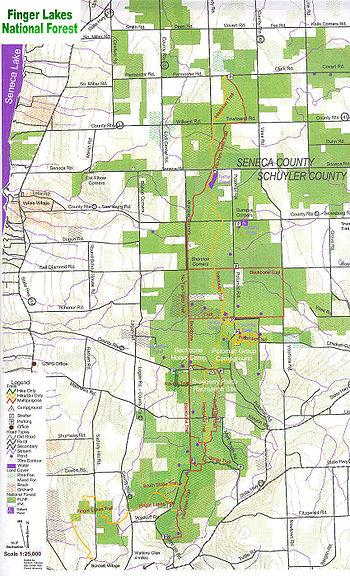
Seneca County, New York
As of the census of 2000, there were 33,342 people, 12,630 households, and 8,626 families residing in the county. The population density was 103 people per square mile . There were 14,794 housing units at an average density of 46 per square mile...
and Schuyler counties
Schuyler County, New York
As of the census of 2000, there were 19,224 people, 7,374 households, and 5,191 families residing in the county. The population density was 58 people per square mile . There were 9,181 housing units at an average density of 28 per square mile...
, nestled between Seneca Lake and Cayuga Lake
Cayuga Lake
Cayuga Lake is the longest of central New York's glacial Finger Lakes, and is the second largest in surface area and second largest in volume. It is just under 40 miles long. Its average width is 1.7 miles , and it is at its widest point near Aurora...
in the Finger Lakes
Finger Lakes
The Finger Lakes are a pattern of lakes in the west-central section of Upstate New York in the United States. They are a popular tourist destination. The lakes are long and thin , each oriented roughly on a north-south axis. The two longest, Cayuga Lake and Seneca Lake, are among the deepest in...
Region of New York
New York
New York is a state in the Northeastern region of the United States. It is the nation's third most populous state. New York is bordered by New Jersey and Pennsylvania to the south, and by Connecticut, Massachusetts and Vermont to the east...
State in the United States of America. The forest has over 30 miles (50 km) of interconnecting trails that traverse gorges, ravine
Ravine
A ravine is a landform narrower than a canyon and is often the product of streamcutting erosion. Ravines are typically classified as larger in scale than gullies, although smaller than valleys. A ravine is generally a fluvial slope landform of relatively steep sides, on the order of twenty to...
s, pasture
Pasture
Pasture is land used for grazing. Pasture lands in the narrow sense are enclosed tracts of farmland, grazed by domesticated livestock, such as horses, cattle, sheep or swine. The vegetation of tended pasture, forage, consists mainly of grasses, with an interspersion of legumes and other forbs...
s, and woodland
Woodland
Ecologically, a woodland is a low-density forest forming open habitats with plenty of sunlight and limited shade. Woodlands may support an understory of shrubs and herbaceous plants including grasses. Woodland may form a transition to shrubland under drier conditions or during early stages of...
s.
Although about 3.2 million acres (1300 km²) of New York state is in State Forest
State forest
A state forest is a forest that is administered or protected by some agency of a sovereign state.The precise application of the term varies by jurisdiction...
Preserves, Wildlife Management Areas
New York State Wildlife Management Areas
New York State owns and maintains more than 85 Wildlife Management Areas , with a total area of more than .The Wildlife Management Areas Program is administered by the Division of Fish, Wildlife and Marine Resources of the Department of Environmental Conservation...
, and Forests, there are few large areas of public land in the Finger Lakes
Finger Lakes
The Finger Lakes are a pattern of lakes in the west-central section of Upstate New York in the United States. They are a popular tourist destination. The lakes are long and thin , each oriented roughly on a north-south axis. The two longest, Cayuga Lake and Seneca Lake, are among the deepest in...
Region. The Finger Lakes National Forest (FLNF) is the only national forest
United States National Forest
National Forest is a classification of federal lands in the United States.National Forests are largely forest and woodland areas owned by the federal government and managed by the United States Forest Service, part of the United States Department of Agriculture. Land management of these areas...
in New York State, and the only public land that has had an explicit philosophy of multiple use.
Early history
The area around the Finger Lakes National Forest was originally inhabited by the IroquoisIroquois
The Iroquois , also known as the Haudenosaunee or the "People of the Longhouse", are an association of several tribes of indigenous people of North America...
Indians. Information of their use of the area within the current forest boundary is sketchy at best. It is thought that at least some hunting activity occurred. This area was a forested hunting territory for the Iroquois people a mere 250 years ago. Just 100 years ago it was nearly tree-less, the result of logging, farming, and grazing practices by Euro-American settlers. Today it is a mix of second growth
Ecological succession
Ecological succession, is the phenomenon or process by which a community progressively transforms itself until a stable community is formed. It is a fundamental concept in ecology, and refers to more or less predictable and orderly changes in the composition or structure of an ecological community...
woodland, pasture and lots which are in a transition from pasture-to-woodland. The cellar holes, stone walls, artifacts, and other material evidence of the former residents of this area are an unwritten reminder and historical record of their lives. They are protected by Federal Law. There are a number of archaeological
Archaeology
Archaeology, or archeology , is the study of human society, primarily through the recovery and analysis of the material culture and environmental data that they have left behind, which includes artifacts, architecture, biofacts and cultural landscapes...
sites on lands managed by the Finger Lakes National Forest, most from the post-Revolutionary period.
Prior to the European rediscovery of eastern North America, Native Americans
Native Americans in the United States
Native Americans in the United States are the indigenous peoples in North America within the boundaries of the present-day continental United States, parts of Alaska, and the island state of Hawaii. They are composed of numerous, distinct tribes, states, and ethnic groups, many of which survive as...
lived in this part of New York for more than 10,000 years. The Iroquois are the last in a series of Indian cultures to have lived here, and two of the six Iroquois Nations' homelands border the Forest. The lakes around which much Indian life took place now bear their names: Cayuga
Cayuga nation
The Cayuga people was one of the five original constituents of the Haudenosaunee , a confederacy of American Indians in New York. The Cayuga homeland lay in the Finger Lakes region along Cayuga Lake, between their league neighbors, the Onondaga to the east and the Seneca to the west...
and Seneca. The lack of reliable water sources and lime-rich soils (good for corn agriculture) precluded development of large year-round Iroquois villages within the Forest's present-day boundaries, but the original forest cover of pines and hardwoods (such as hickory
Hickory
Trees in the genus Carya are commonly known as hickory, derived from the Powhatan language of Virginia. The genus includes 17–19 species of deciduous trees with pinnately compound leaves and big nuts...
, elm
Elm
Elms are deciduous and semi-deciduous trees comprising the genus Ulmus in the plant family Ulmaceae. The dozens of species are found in temperate and tropical-montane regions of North America and Eurasia, ranging southward into Indonesia. Elms are components of many kinds of natural forests...
, beech
Beech
Beech is a genus of ten species of deciduous trees in the family Fagaceae, native to temperate Europe, Asia and North America.-Habit:...
, chestnut
Chestnut
Chestnut , some species called chinkapin or chinquapin, is a genus of eight or nine species of deciduous trees and shrubs in the beech family Fagaceae, native to temperate regions of the Northern Hemisphere. The name also refers to the edible nuts they produce.-Species:The chestnut belongs to the...
, oak
Oak
An oak is a tree or shrub in the genus Quercus , of which about 600 species exist. "Oak" may also appear in the names of species in related genera, notably Lithocarpus...
, and maple
Maple
Acer is a genus of trees or shrubs commonly known as maple.Maples are variously classified in a family of their own, the Aceraceae, or together with the Hippocastanaceae included in the family Sapindaceae. Modern classifications, including the Angiosperm Phylogeny Group system, favour inclusion in...
) would have made this a good hunting
Hunting
Hunting is the practice of pursuing any living thing, usually wildlife, for food, recreation, or trade. In present-day use, the term refers to lawful hunting, as distinguished from poaching, which is the killing, trapping or capture of the hunted species contrary to applicable law...
and nut-gathering territory for these people.
American Revolution
Because of the Iroquois alliance with the BritishGreat Britain
Great Britain or Britain is an island situated to the northwest of Continental Europe. It is the ninth largest island in the world, and the largest European island, as well as the largest of the British Isles...
during the American Revolution
American Revolution
The American Revolution was the political upheaval during the last half of the 18th century in which thirteen colonies in North America joined together to break free from the British Empire, combining to become the United States of America...
, George Washington
George Washington
George Washington was the dominant military and political leader of the new United States of America from 1775 to 1799. He led the American victory over Great Britain in the American Revolutionary War as commander-in-chief of the Continental Army from 1775 to 1783, and presided over the writing of...
assigned Generals Sullivan
John Sullivan
John Sullivan was the third son of Irish immigrants, a United States general in the Revolutionary War, a delegate in the Continental Congress and a United States federal judge....
and Clinton
James Clinton
James Clinton was an American Revolutionary War soldier who obtained the rank of major general.He was born in Ulster County in the colony of New York, in a location now part of Orange County, New York...
to mount a campaign against them. The Sullivan Campaign
Sullivan Expedition
The Sullivan Expedition, also known as the Sullivan-Clinton Expedition, was an American campaign led by Major General John Sullivan and Brigadier General James Clinton against Loyalists and the four nations of the Iroquois who had sided with the British in the American Revolutionary War.The...
of 1779 was major military undertaking which destroyed more than 40 villages and laid to waste hundreds of acres of cultivated fields and a large portion of the stored food and materials the Iroquois and British were dependent upon.
A secondary, non-military result of the neutralization of the Six Nations Iroquois in this region was that it created "new" lands to allot to Colonial soldiers after the war in partial payment or reward for their service. The land was divided up into "military lots", the one mile (1.6 km) square (2.6 km²) units that are still the basis for the road (and much of the trail) system present on the Finger Lakes National Forest today. In 1790, the area was divided into 600 acre (2.4 km²) military lots and distributed among Revolutionary War veterans as payment for their services. These early settlers cleared the land for production of hay and small grains such as buckwheat
Buckwheat
Buckwheat refers to a variety of plants in the dicot family Polygonaceae: the Eurasian genus Fagopyrum, the North American genus Eriogonum, and the Northern Hemisphere genus Fallopia. Either of the latter two may be referred to as "wild buckwheat"...
. As New York City
New York City
New York is the most populous city in the United States and the center of the New York Metropolitan Area, one of the most populous metropolitan areas in the world. New York exerts a significant impact upon global commerce, finance, media, art, fashion, research, technology, education, and...
grew, a strong market for these products developed, encouraging more intensive agriculture. The farmers prospered until the mid-19th century, when a series of unfortunate events occurred - the popularity of motorized transportation in urban centers (reducing the number of horses to be fed), gradual depletion of the soil resource, and competition from the midwest.
Federal purchase of the land
Between 1890 and the Great DepressionGreat Depression
The Great Depression was a severe worldwide economic depression in the decade preceding World War II. The timing of the Great Depression varied across nations, but in most countries it started in about 1929 and lasted until the late 1930s or early 1940s...
, over 1 million acres (4000 km²) of farmland was abandoned in south central New York State. In the 1930s it was recognized that farmers in many parts of the country could no longer make a living from their exhausted land. Environmental damage was occurring as they cultivated the land more and more intensively to make ends meet. Several pieces of legislation were passed, including the Federal Emergency Relief Act of 1933, and the Bankhead-Jones Farm Tenant Act of 1937 to address these problems. One result was the formation of a government agency, the Resettlement Administration, to carry out the new laws. This agency directed the relocation of farmers to better !and or other jobs, and the purchase of marginal farm
Farm
A farm is an area of land, or, for aquaculture, lake, river or sea, including various structures, devoted primarily to the practice of producing and managing food , fibres and, increasingly, fuel. It is the basic production facility in food production. Farms may be owned and operated by a single...
land by the Federal government. Between 1938 and 1941, over 100 farms were purchased in the area now in the National Forest. Because this was done on a willing-seller, willing-buyer basis, the resulting Federal ownership resembled a patchwork quilt. This was especially true in the Seneca County
Seneca County, New York
As of the census of 2000, there were 33,342 people, 12,630 households, and 8,626 families residing in the county. The population density was 103 people per square mile . There were 14,794 housing units at an average density of 46 per square mile...
end of the Forest, where soils were more productive, and some families elected to stay. This ownership pattern still exists today.
The newly acquired Federal land, named the Hector Land Use Area (LUA), was initially managed by the Soil Conservation Service. The emphasis was on stabilization of the soil
Soil
Soil is a natural body consisting of layers of mineral constituents of variable thicknesses, which differ from the parent materials in their morphological, physical, chemical, and mineralogical characteristics...
by planting conifers, and development of a grazing program. Previously cultivated fields were converted to improved pastures to demonstrate how less intensive agriculture could still make productive use of the land. In 1943, the Hector Cooperative Grazing Association was formed. This organization was issued a long term lease to manage grazing on the (LUA). They coordinated use of the pastures by as many as 120 individual livestock
Livestock
Livestock refers to one or more domesticated animals raised in an agricultural setting to produce commodities such as food, fiber and labor. The term "livestock" as used in this article does not include poultry or farmed fish; however the inclusion of these, especially poultry, within the meaning...
owners within a 100 mile (160 km) radius of the (LUA).
In 1996, the property associated with the former Camp Fossenvue was added to the forest. On that property is the Queen's Castle
Queen's Castle
Queen's Castle, also known as Camp Fossenvue or simply Fossenvue, is the remnant of a historic camp located at Lodi in Seneca County, New York. It is a rustic, lakeside camp structure built about 1881 on the shore of Seneca Lake. It is a one story, roughly square, 17 feet, 6 inches by 18...
, a structure listed on the National Register of Historic Places
National Register of Historic Places
The National Register of Historic Places is the United States government's official list of districts, sites, buildings, structures, and objects deemed worthy of preservation...
in 1999.
Creation of the national forest
By the 1950s, many of the original objectives of the Hector (LUA) had been met. Farmers had been resettled, the eroding soil stabilized, and alternative agriculture uses demonstrated. At the same time, the public was becoming interested in the concept of multiple uses of public land. Management and appropriate ownership of the Hector LUA was reevaluated. The decision was made in 1954 to transfer administrative responsibilities to the U.S. Forest Service, which already had a fairly long history of multiple use management. Initially this was carried out by the Regional Office in Upper Darby, Pennsylvania. When this region was later consolidated within the Forest Service's Northeast Region, Hector became an administrative unit of the Green Mountain National Forest in VermontVermont
Vermont is a state in the New England region of the northeastern United States of America. The state ranks 43rd in land area, , and 45th in total area. Its population according to the 2010 census, 630,337, is the second smallest in the country, larger only than Wyoming. It is the only New England...
.
In 1982, the Federal land management agencies were directed to identify isolated parcels of federal land that could be sold without significantly affecting the resource base or public service. The intent was to dispose of lands that were inefficient to manage, and to generate revenue. The Hector Land Use Area was one parcel studied for possible disposal under this "Assets Management" program. When public meetings were held to evaluate this idea, there was strong local support for continued federal ownership. Local and regional citizens had come to depend on Hector for wood products, forage, recreation, and other benefits. Because of this public support, Congress enacted legislation to make it a permanent part of the National Forest
United States National Forest
National Forest is a classification of federal lands in the United States.National Forests are largely forest and woodland areas owned by the federal government and managed by the United States Forest Service, part of the United States Department of Agriculture. Land management of these areas...
System. The Hector Ranger District, Green Mountain National Forest, had been created. Local citizens asked the Forest Service to change the name to Hector Ranger District, Finger Lakes National Forest, so it would be less confusing to visitors, and promote local pride about the area. This change was made in October 1985.
The forest today
The national forest is a public use resource in both Seneca CountySeneca County, New York
As of the census of 2000, there were 33,342 people, 12,630 households, and 8,626 families residing in the county. The population density was 103 people per square mile . There were 14,794 housing units at an average density of 46 per square mile...
and Schuyler County
Schuyler County, New York
As of the census of 2000, there were 19,224 people, 7,374 households, and 5,191 families residing in the county. The population density was 58 people per square mile . There were 9,181 housing units at an average density of 28 per square mile...
, lying between Cayuga Lake
Cayuga Lake
Cayuga Lake is the longest of central New York's glacial Finger Lakes, and is the second largest in surface area and second largest in volume. It is just under 40 miles long. Its average width is 1.7 miles , and it is at its widest point near Aurora...
and Seneca Lake.
The Finger Lakes National Forest is still an administrative unit of the Green Mountain National Forest
Green Mountain National Forest
Green Mountain National Forest is a national forest located in Vermontwhich supports a variety of wildlife, including beaver, moose, black bear, and white tailed deer. It also supports an abundant variety of bird species. The forest has been referred to as the 'granite backbone' of the state...
. Both are managed by the Forest Service from offices in Rutland, Vermont. The Forest has continued the management mix of pasture, forest, recreation and wildlife and includes the preservation of historic and archaeological sites. It is the second-smallest National Forest in the United States, larger than only the Tuskegee National Forest
Tuskegee National Forest
The Tuskegee National Forest is a U.S. National Forest located in Macon County, Alabama, just north of Tuskegee and west of Auburn. The topography is level to moderately sloping, with broad ridges with stream terraces and broad floodplains....
in Alabama.