

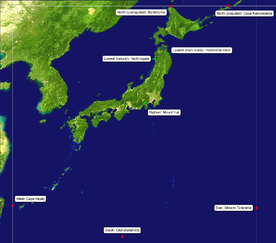
Extreme points of Japan
Encyclopedia
Kuril Islands dispute
The Kuril Islands dispute , also known as the , is a dispute between Japan and Russia over sovereignty over the South Kuril Islands. The disputed islands, which were occupied by Soviet forces during the Manchurian Strategic Offensive Operation at the end of World War II, are under Russian...
, as both Japan and Russia
Russia
Russia or , officially known as both Russia and the Russian Federation , is a country in northern Eurasia. It is a federal semi-presidential republic, comprising 83 federal subjects...
have claimed Iturup
Iturup
Iturup is the largest island of the South Kuril Islands. It is the northernmost island in the southern Kuril/Chishima islands, and though it is presently controlled by Russia, Japan also claims this island...
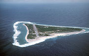
, the island on which the point is located. The southern-most point is Okinotorishima
Okinotorishima
is an atoll, which in English has multiple designations . Its original name was Parece Vela Spanish for "looks like a sail"...
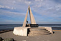
; the western-most is Cape Irizaki
Cape Irizaki
is the western tip of Yonaguni island and the westernmost point in Japan. It is located at .It is open to the public. There is a lighthouse, an observation platform, and a monument. Taiwan, which is about 110 kilometers away, is visible on a clear day....
in Okinawa Prefecture
Okinawa Prefecture
is one of Japan's southern prefectures. It consists of hundreds of the Ryukyu Islands in a chain over long, which extends southwest from Kyūshū to Taiwan. Okinawa's capital, Naha, is located in the southern part of Okinawa Island...
, and the eastern-most is Minami Torishima
Minami Torishima
or Marcus Island is an isolated Japanese coral atoll in the northwestern Pacific Ocean, located some SE of Tokyo and east of the closest Japanese island, South Iwo Jima of the Ogasawara Islands, and nearly on a straight line between Tokyo and Wake Island, which is east southeast...
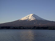
. The highest point in Japan is the summit of Mount Fuji
Mount Fuji
is the highest mountain in Japan at . An active stratovolcano that last erupted in 1707–08, Mount Fuji lies about south-west of Tokyo, and can be seen from there on a clear day. Mount Fuji's exceptionally symmetrical cone is a well-known symbol of Japan and it is frequently depicted in art and...
at 3,776 metres (12,388 ft). At 150 m (492 ft) below sea level
Sea level
Mean sea level is a measure of the average height of the ocean's surface ; used as a standard in reckoning land elevation...
, the bottom of Hachinohe mine
Hachinohe mine
The is an open-pit mine in Hachinohe, Aomori Prefecture, Japan. It is mined for limestone and currently operated by the Sumimetal Mining Company.The mine is the lowest point in Japan at 160 meters below sea level, and digging still continues. It is known locally as the "Hachinohe Canyon."-External...
is the country's lowest point. The surface of Hachirōgata
Hachirogata
Hachirōgata is a lake in the Akita Prefecture in northern Japan. Its formal name is Lake Hachirō , but it is also called Hachirōgata Regulating Pond . At 4 meters below sea level, Hachirōgata is now the lowest point in Japan.Hachirōgata was the second-largest lake in Japan after Lake Biwa...
is Japan's lowest natural point at 4 m (13 ft) below sea level. With the exception of Cape Irizaki
Cape Irizaki
is the western tip of Yonaguni island and the westernmost point in Japan. It is located at .It is open to the public. There is a lighthouse, an observation platform, and a monument. Taiwan, which is about 110 kilometers away, is visible on a clear day....
, the western-most location of Japan, all other extreme locations are uninhabited.
The coordinates used in this article are sourced from Google Earth
Google Earth
Google Earth is a virtual globe, map and geographical information program that was originally called EarthViewer 3D, and was created by Keyhole, Inc, a Central Intelligence Agency funded company acquired by Google in 2004 . It maps the Earth by the superimposition of images obtained from satellite...
, which makes use of the World Geodetic System
World Geodetic System
The World Geodetic System is a standard for use in cartography, geodesy, and navigation. It comprises a standard coordinate frame for the Earth, a standard spheroidal reference surface for raw altitude data, and a gravitational equipotential surface that defines the nominal sea level.The latest...
(WGS) 84.
Extreme points

Kuril Islands dispute
The Kuril Islands dispute , also known as the , is a dispute between Japan and Russia over sovereignty over the South Kuril Islands. The disputed islands, which were occupied by Soviet forces during the Manchurian Strategic Offensive Operation at the end of World War II, are under Russian...
island of Iturup
Iturup
Iturup is the largest island of the South Kuril Islands. It is the northernmost island in the southern Kuril/Chishima islands, and though it is presently controlled by Russia, Japan also claims this island...
. Japan's claim to the three southern-most islands of the Kuril Islands
Kuril Islands
The Kuril Islands , in Russia's Sakhalin Oblast region, form a volcanic archipelago that stretches approximately northeast from Hokkaidō, Japan, to Kamchatka, Russia, separating the Sea of Okhotsk from the North Pacific Ocean. There are 56 islands and many more minor rocks. It consists of Greater...
is disputed by Russia, who currently controls the islands. This list provides the northern-most point as claimed by Japan as well as the northern-most undisputed point in Japan.
Overall
| Heading | Location | Prefecture Prefectures of Japan The prefectures of Japan are the country's 47 subnational jurisdictions: one "metropolis" , Tokyo; one "circuit" , Hokkaidō; two urban prefectures , Osaka and Kyoto; and 43 other prefectures . In Japanese, they are commonly referred to as... |
Bordering entity | Coordinates | Ref |
|---|---|---|---|---|---|
| North (disputed) |
Cape Kamoiwakka Cape Koritskiy Cape Koritsky is the northernmost point of Iturup, one of the Kuril Islands. In Japanese, the cape is called either or .The Southern Kuril Islands, including Iturup, are currently administrated by Russia. However, Japan also claims these islands... |
Hokkaido Hokkaido , formerly known as Ezo, Yezo, Yeso, or Yesso, is Japan's second largest island; it is also the largest and northernmost of Japan's 47 prefectural-level subdivisions. The Tsugaru Strait separates Hokkaido from Honshu, although the two islands are connected by the underwater railway Seikan Tunnel... |
Sea of Okhotsk Sea of Okhotsk The Sea of Okhotsk is a marginal sea of the western Pacific Ocean, lying between the Kamchatka Peninsula on the east, the Kuril Islands on the southeast, the island of Hokkaidō to the far south, the island of Sakhalin along the west, and a long stretch of eastern Siberian coast along the west and... |
45°33′25.87"N 148°45′8.52"E | |
| North (undisputed) |
Bentenjima Bentenjima (Wakkanai) is a small deserted island west by northwest of Cape Sōya, Wakkanai, Hokkaidō, Japan. It is the northernmost piece of land under Japanese control. The island is 1km north of Sannai settlement. Another island called lies southeast of Bentenjima.... |
Hokkaidō Hokkaido , formerly known as Ezo, Yezo, Yeso, or Yesso, is Japan's second largest island; it is also the largest and northernmost of Japan's 47 prefectural-level subdivisions. The Tsugaru Strait separates Hokkaido from Honshu, although the two islands are connected by the underwater railway Seikan Tunnel... |
La Pérouse Strait La Perouse Strait La Pérouse Strait is a strait dividing the southern part of the Russian island of Sakhalin from the northern part of the Japanese island of Hokkaidō, and connecting the Sea of Japan on the west with the Sea of Okhotsk on the east.... |
45°31′38.41"N 141°55′5.56"E | |
| South | Okinotorishima Okinotorishima is an atoll, which in English has multiple designations . Its original name was Parece Vela Spanish for "looks like a sail"... |
Tokyo Tokyo , ; officially , is one of the 47 prefectures of Japan. Tokyo is the capital of Japan, the center of the Greater Tokyo Area, and the largest metropolitan area of Japan. It is the seat of the Japanese government and the Imperial Palace, and the home of the Japanese Imperial Family... |
Philippine Sea Philippine Sea The Philippine Sea is a marginal sea east and north of the Philippines occupying an estimated surface area of 2 million mi² on the western part of the North Pacific Ocean... |
20°25′31"N 136°04′11"E | |
| East | Minami Torishima Minami Torishima or Marcus Island is an isolated Japanese coral atoll in the northwestern Pacific Ocean, located some SE of Tokyo and east of the closest Japanese island, South Iwo Jima of the Ogasawara Islands, and nearly on a straight line between Tokyo and Wake Island, which is east southeast... |
Tokyo Tokyo , ; officially , is one of the 47 prefectures of Japan. Tokyo is the capital of Japan, the center of the Greater Tokyo Area, and the largest metropolitan area of Japan. It is the seat of the Japanese government and the Imperial Palace, and the home of the Japanese Imperial Family... |
Pacific Ocean Pacific Ocean The Pacific Ocean is the largest of the Earth's oceanic divisions. It extends from the Arctic in the north to the Southern Ocean in the south, bounded by Asia and Australia in the west, and the Americas in the east.At 165.2 million square kilometres in area, this largest division of the World... |
24°16′59"N 153°59′11"E | |
| West | Cape Irizaki Cape Irizaki is the western tip of Yonaguni island and the westernmost point in Japan. It is located at .It is open to the public. There is a lighthouse, an observation platform, and a monument. Taiwan, which is about 110 kilometers away, is visible on a clear day.... |
Okinawa Okinawa Prefecture is one of Japan's southern prefectures. It consists of hundreds of the Ryukyu Islands in a chain over long, which extends southwest from Kyūshū to Taiwan. Okinawa's capital, Naha, is located in the southern part of Okinawa Island... |
East China Sea East China Sea The East China Sea is a marginal sea east of China. It is a part of the Pacific Ocean and covers an area of 1,249,000 km² or 750,000 square miles.-Geography:... |
24°26′58"N 122°56′01"E |
Four main islands
Hokkaido
, formerly known as Ezo, Yezo, Yeso, or Yesso, is Japan's second largest island; it is also the largest and northernmost of Japan's 47 prefectural-level subdivisions. The Tsugaru Strait separates Hokkaido from Honshu, although the two islands are connected by the underwater railway Seikan Tunnel...
, Honshū
Honshu
is the largest island of Japan. The nation's main island, it is south of Hokkaido across the Tsugaru Strait, north of Shikoku across the Inland Sea, and northeast of Kyushu across the Kanmon Strait...
, Kyūshū
Kyushu
is the third largest island of Japan and most southwesterly of its four main islands. Its alternate ancient names include , , and . The historical regional name is referred to Kyushu and its surrounding islands....
and Shikoku
Shikoku
is the smallest and least populous of the four main islands of Japan, located south of Honshū and east of the island of Kyūshū. Its ancient names include Iyo-no-futana-shima , Iyo-shima , and Futana-shima...
. All of these points are accessible to public.
| Heading | Location | Prefecture Prefectures of Japan The prefectures of Japan are the country's 47 subnational jurisdictions: one "metropolis" , Tokyo; one "circuit" , Hokkaidō; two urban prefectures , Osaka and Kyoto; and 43 other prefectures . In Japanese, they are commonly referred to as... |
Bordering entity | Coordinates | Ref |
|---|---|---|---|---|---|
| North | Cape Sōya Cape Soya is the northernmost point of the island of Hokkaidō, Japan. It is situated in Wakkanai, Sōya Subprefecture. The is at the cape, although the true northernmost point under Japanese control is a small deserted island called Bentenjima, 1 km northwest... |
Hokkaidō Hokkaido , formerly known as Ezo, Yezo, Yeso, or Yesso, is Japan's second largest island; it is also the largest and northernmost of Japan's 47 prefectural-level subdivisions. The Tsugaru Strait separates Hokkaido from Honshu, although the two islands are connected by the underwater railway Seikan Tunnel... |
La Pérouse Strait La Perouse Strait La Pérouse Strait is a strait dividing the southern part of the Russian island of Sakhalin from the northern part of the Japanese island of Hokkaidō, and connecting the Sea of Japan on the west with the Sea of Okhotsk on the east.... |
45°31′22"N 141°56′11"E | |
| South | Cape Sata Cape Sata Cape Sata is a cape at the southern tip of the Osumi Peninsula of Kyūshū island, Japan, and is the southernmost point of the island, just south of 31 degrees latitude.... |
Kagoshima Kagoshima Prefecture is a prefecture of Japan located on the island of Kyushu. The capital is the city of Kagoshima.- Geography :Kagoshima Prefecture is located at the southwest tip of Kyushu and includes a chain of islands stretching further to the southwest for a few hundred kilometers... |
East China Sea East China Sea The East China Sea is a marginal sea east of China. It is a part of the Pacific Ocean and covers an area of 1,249,000 km² or 750,000 square miles.-Geography:... |
30°59′39"N 130°39′38.3"E | |
| East | Cape Nosappu | Hokkaidō Hokkaido , formerly known as Ezo, Yezo, Yeso, or Yesso, is Japan's second largest island; it is also the largest and northernmost of Japan's 47 prefectural-level subdivisions. The Tsugaru Strait separates Hokkaido from Honshu, although the two islands are connected by the underwater railway Seikan Tunnel... |
Pacific Ocean Pacific Ocean The Pacific Ocean is the largest of the Earth's oceanic divisions. It extends from the Arctic in the north to the Southern Ocean in the south, bounded by Asia and Australia in the west, and the Americas in the east.At 165.2 million square kilometres in area, this largest division of the World... |
43°23′06"N 145°49′03"E | |
| West | Kōzakihana Kozakihana is a cape located in Sasebo, Nagasaki, Japan. It is the western-most point of the island Kyūshū as well as the western-most point of Japan's four main islands.-See also:* Extreme points of Japan... |
Nagasaki Nagasaki Prefecture is a prefecture of Japan located on the island of Kyūshū. The capital is the city of Nagasaki.- History :Nagasaki Prefecture was created by merging of the western half of the former province of Hizen with the island provinces of Tsushima and Iki... |
East China Sea East China Sea The East China Sea is a marginal sea east of China. It is a part of the Pacific Ocean and covers an area of 1,249,000 km² or 750,000 square miles.-Geography:... |
33°13′4"N 129°33′9"E |
Hokkaidō
| Heading | Location | Prefecture Prefectures of Japan The prefectures of Japan are the country's 47 subnational jurisdictions: one "metropolis" , Tokyo; one "circuit" , Hokkaidō; two urban prefectures , Osaka and Kyoto; and 43 other prefectures . In Japanese, they are commonly referred to as... |
Bordering entity | Coordinates | Ref |
|---|---|---|---|---|---|
| North | Cape Sōya Cape Soya is the northernmost point of the island of Hokkaidō, Japan. It is situated in Wakkanai, Sōya Subprefecture. The is at the cape, although the true northernmost point under Japanese control is a small deserted island called Bentenjima, 1 km northwest... |
Hokkaidō Hokkaido , formerly known as Ezo, Yezo, Yeso, or Yesso, is Japan's second largest island; it is also the largest and northernmost of Japan's 47 prefectural-level subdivisions. The Tsugaru Strait separates Hokkaido from Honshu, although the two islands are connected by the underwater railway Seikan Tunnel... |
La Pérouse Strait La Perouse Strait La Pérouse Strait is a strait dividing the southern part of the Russian island of Sakhalin from the northern part of the Japanese island of Hokkaidō, and connecting the Sea of Japan on the west with the Sea of Okhotsk on the east.... |
45°31′22"N 141°56′11"E | |
| South | Cape Shirakami Cape Shirakami is a cape located on the southern-most tip of the Oshima Peninsula in Matsumae, Hokkaidō, Japan. It is the southern-most point of Hokkaidō.-See also:*Extreme points of Japan... |
Hokkaidō Hokkaido , formerly known as Ezo, Yezo, Yeso, or Yesso, is Japan's second largest island; it is also the largest and northernmost of Japan's 47 prefectural-level subdivisions. The Tsugaru Strait separates Hokkaido from Honshu, although the two islands are connected by the underwater railway Seikan Tunnel... |
Tsugaru Strait Tsugaru Strait is a channel between Honshu and Hokkaido in northern Japan connecting the Sea of Japan with the Pacific Ocean. It was named after the western part of Aomori Prefecture... |
41°23′50.5"N 140°11′50.6"E | |
| East | Cape Nosappu | Hokkaidō Hokkaido , formerly known as Ezo, Yezo, Yeso, or Yesso, is Japan's second largest island; it is also the largest and northernmost of Japan's 47 prefectural-level subdivisions. The Tsugaru Strait separates Hokkaido from Honshu, although the two islands are connected by the underwater railway Seikan Tunnel... |
Pacific Ocean Pacific Ocean The Pacific Ocean is the largest of the Earth's oceanic divisions. It extends from the Arctic in the north to the Southern Ocean in the south, bounded by Asia and Australia in the west, and the Americas in the east.At 165.2 million square kilometres in area, this largest division of the World... |
43°23′06"N 145°49′03"E | |
| West | Cape Obana | Hokkaidō Hokkaido , formerly known as Ezo, Yezo, Yeso, or Yesso, is Japan's second largest island; it is also the largest and northernmost of Japan's 47 prefectural-level subdivisions. The Tsugaru Strait separates Hokkaido from Honshu, although the two islands are connected by the underwater railway Seikan Tunnel... |
Sea of Japan Sea of Japan The Sea of Japan is a marginal sea of the western Pacific Ocean, between the Asian mainland, the Japanese archipelago and Sakhalin. It is bordered by Japan, North Korea, Russia and South Korea. Like the Mediterranean Sea, it has almost no tides due to its nearly complete enclosure from the Pacific... |
42°18′11.4"N 139°46′1"E |
Honshū
Northernmost point, ŌmaOma, Aomori
is a town located in northeastern Aomori in Tōhoku region of Japan. As of 2009, the town had an estimated population of 5,950 and a density of 114 persons per km². Its total area was 52.06 km².-Geography:...
, Aomori Prefecture
Aomori Prefecture
is a prefecture of Japan located in the Tōhoku Region. The capital is the city of Aomori.- History :Until the Meiji Restoration, the area of Aomori prefecture was known as Mutsu Province....
Southernmost point, Kushimoto
Kushimoto, Wakayama
-Demographics:The population of Kushimoto is 20,618, consisting of 9,561 men and 11,057 women. There are a total of 9,397 families.-Junior high schools:*Kushimoto Junior High School*Kushimoto-Nishi Junior High School*Nishi-Mukai Junior High School...
, Wakayama Prefecture
Wakayama Prefecture
is a prefecture of Japan located on the Kii Peninsula in the Kansai region on Honshū island. The capital is the city of Wakayama.- History :Present-day Wakayama is mostly the western part of the province of Kii.- 1953 Wakayama Prefecture flood disaster :...
Westernmost point, Shimonoseki
Shimonoseki, Yamaguchi
is a city located in Yamaguchi Prefecture, Japan. It is at the southwestern tip of Honshū, facing the Tsushima Strait and also Kitakyushu across the Kanmon Straits....
, Yamaguchi Prefecture
Yamaguchi Prefecture
is a prefecture of Japan in the Chūgoku region on Honshū island. The capital is the city of Yamaguchi, in the center of the prefecture. The largest city, however, is Shimonoseki.- History :...
Easternmost point, Miyako
Miyako, Iwate
is a city located in Iwate, Japan.It was founded on February 11, 1941.The city lies along the coast where the flows into the Pacific Ocean. It is connected to Morioka by an east-west train line and highway and the coastal highway also goes through the town...
, Iwate Prefecture
Iwate Prefecture
is the second largest prefecture of Japan after Hokkaido. It is located in the Tōhoku region of Honshū island and contains the island's easternmost point. The capital is Morioka. Iwate has the lowest population density of any prefecture outside Hokkaido...
Shikoku
| Heading | Location | Prefecture Prefectures of Japan The prefectures of Japan are the country's 47 subnational jurisdictions: one "metropolis" , Tokyo; one "circuit" , Hokkaidō; two urban prefectures , Osaka and Kyoto; and 43 other prefectures . In Japanese, they are commonly referred to as... |
Bordering entity | Coordinates | Ref |
|---|---|---|---|---|---|
| North | Cape Takei | Kagawa Kagawa Prefecture is a prefecture of Japan located on Shikoku island. The capital is Takamatsu.- History :Kagawa was formerly known as Sanuki Province.For a brief period between August 1876 and December 1888, Kagawa was made a part of Ehime Prefecture.-Battle of Yashima:... |
Bungo Channel Bungo Channel The is a strait separating the Japanese islands of Kyūshū and Shikoku. It connects the Pacific Ocean and Seto Inland Sea. The narrowest part of this channel is the Hōyo Strait.... |
34°24′01.25"N 134°08′12.05"E | |
| South | Cape Ashizuri Ashizuri-Uwakai National Park is a national park at the southwestern tip of the island of Shikoku, Japan. The main attraction is Cape Ashizuri, the southernmost point of the island, with craggy cliffs and views over the endless expanse of the Pacific Ocean... |
Kōchi Kochi Prefecture is a prefecture of Japan located on the south coast of Shikoku. The capital is the city of Kōchi.- History :Prior to the Meiji Restoration, Kōchi was known as Tosa Province and was controlled by the Chosokabe clan in the Sengoku period and the Yamauchi family during the Edo period.- Geography... |
Philippine Sea Philippine Sea The Philippine Sea is a marginal sea east and north of the Philippines occupying an estimated surface area of 2 million mi² on the western part of the North Pacific Ocean... |
32°43′19.36"N 133°00′18.93"E | |
| East | Cape Gamōda | Tokushima Tokushima Prefecture is a prefecture of Japan located on Shikoku island. The capital is the city of Tokushima.- Tokushima Prefecture and Myodo Prefecture :Long ago, Tokushima City belonged to a region known as Myōdō-gun... |
Kii Channel Kii Channel The is a strait separating the Japanese Home Islands of Honshū and Shikoku. This channel connects the Inland Sea with the Pacific Ocean.... |
33°50′3.30"N 134°44′59.92"E | |
| West | Cape Sada | Ehime Ehime Prefecture is a prefecture in northwestern Shikoku, Japan. The capital is Matsuyama.-History:Until the Meiji Restoration, Ehime prefecture was known as Iyo Province... |
Hōyo Strait Hoyo Strait The is the strait at the narrowest part of the Bungo Channel in Japan.... |
33°20′38"N 132°00′44.57"E |
Kyūshū
Northernmost point, Kitakyūshū, Fukuoka PrefectureFukuoka Prefecture
is a prefecture of Japan located on Kyūshū Island. The capital is the city of Fukuoka.- History :Fukuoka Prefecture includes the former provinces of Chikugo, Chikuzen, and Buzen....
Southernmost point, Minamiōsumi, Kagoshima Prefecture 30°59′10"N 130°39′42"E
Westernmost point, Sasebo, Nagasaki Prefecture 33°12′51"N 129°33′18"E
Easternmost point, Saiki
Saiki, Oita
is a city located in Ōita Prefecture, Japan.As of 2003, the former city had an estimated population of 49,183 and the density of 249.19 persons per km²...
, Ōita Prefecture
Oita Prefecture
is a prefecture of Japan on Kyūshū Island. The prefectural capital is the city of Ōita.- History :Around the 6th century Kyushu consisted of four regions: Tsukushi-no-kuni 筑紫国, Hi-no-kuni 肥国, and Toyo no kuni...
Extreme altitudes
| Extremity | Name | Altitude | Prefecture Prefectures of Japan The prefectures of Japan are the country's 47 subnational jurisdictions: one "metropolis" , Tokyo; one "circuit" , Hokkaidō; two urban prefectures , Osaka and Kyoto; and 43 other prefectures . In Japanese, they are commonly referred to as... |
Coordinates | Ref |
|---|---|---|---|---|---|
| Highest | Mount Fuji Mount Fuji is the highest mountain in Japan at . An active stratovolcano that last erupted in 1707–08, Mount Fuji lies about south-west of Tokyo, and can be seen from there on a clear day. Mount Fuji's exceptionally symmetrical cone is a well-known symbol of Japan and it is frequently depicted in art and... |
3776 m (12,388 ft) | Yamanashi Yamanashi Prefecture is a prefecture of Japan located in the Chūbu region of the island of Honshū. The capital is the city of Kōfu.-Pre-history to the 14th century:People have been living in the Yamanashi area for about 30,000 years... |
35°21′28.8"N 138°43′51.6"E | |
| Lowest (man-made) |
Hachinohe mine Hachinohe mine The is an open-pit mine in Hachinohe, Aomori Prefecture, Japan. It is mined for limestone and currently operated by the Sumimetal Mining Company.The mine is the lowest point in Japan at 160 meters below sea level, and digging still continues. It is known locally as the "Hachinohe Canyon."-External... |
−150 m (−492 ft) | Aomori Aomori Prefecture is a prefecture of Japan located in the Tōhoku Region. The capital is the city of Aomori.- History :Until the Meiji Restoration, the area of Aomori prefecture was known as Mutsu Province.... |
40°27′10.4"N 141°32′15.8"E | |
| Lowest (natural) |
Hachirōgata Hachirogata Hachirōgata is a lake in the Akita Prefecture in northern Japan. Its formal name is Lake Hachirō , but it is also called Hachirōgata Regulating Pond . At 4 meters below sea level, Hachirōgata is now the lowest point in Japan.Hachirōgata was the second-largest lake in Japan after Lake Biwa... |
−4 m (−13 ft) | Akita Akita Prefecture is a prefecture of Japan located in the Tōhoku Region of northern Honshu, the main island of Japan. The capital is the city of Akita.- History :The area of Akita has been created from the ancient provinces of Dewa and Mutsu.... |
39°54′50"N 140°01′15"E |
See also
- Geography of JapanGeography of JapanJapan is an island nation in East Asia comprising a stratovolcanic archipelago extending along the Pacific coast of Asia. Measured from the geographic coordinate system, Japan stretches from 24° to 46° north latitude and from 123° to 146° east longitude...
- Extreme points of Asia
- Kuril Islands disputeKuril Islands disputeThe Kuril Islands dispute , also known as the , is a dispute between Japan and Russia over sovereignty over the South Kuril Islands. The disputed islands, which were occupied by Soviet forces during the Manchurian Strategic Offensive Operation at the end of World War II, are under Russian...