
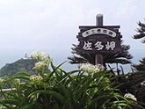
Cape Sata
Encyclopedia

Osumi Peninsula
thumb|right|240px|Satellite image of Osumi PeninsulaThe projects south from the Japanese island of Kyūshū and includes the southernmost point on the island, Cape Sata. Its east coast lies on the Pacific Ocean, while to the west it faces the Satsuma Peninsula across Kagoshima Bay...
of Kyūshū
Kyushu
is the third largest island of Japan and most southwesterly of its four main islands. Its alternate ancient names include , , and . The historical regional name is referred to Kyushu and its surrounding islands....
island, Japan, and is the southernmost point of the island, just south of 31 degrees latitude
31st parallel north
The 31st parallel north is a circle of latitude that is 31 degrees north of the Earth's equatorial plane. It crosses Africa, Asia, the Pacific Ocean, North America and the Atlantic Ocean.Part of the border between Iran and Iraq is defined by the parallel....
.
Cape Sata is home to a lighthouse
Lighthouse
A lighthouse is a tower, building, or other type of structure designed to emit light from a system of lamps and lenses or, in older times, from a fire, and used as an aid to navigation for maritime pilots at sea or on inland waterways....
built in 1871, designed by the Scotsman Richard Henry Brunton
Richard Henry Brunton
Richard Henry Brunton FRGS MICE was the so-called "Father of Japanese lighthouses". Brunton was born in Muchalls, Kincardineshire, Scotland...
.
The land is currently under the jurisdiction of a private company, and costs 300 yen to enter with open hours between 9 and 5.
Alan Booth
Alan Booth
Alan Booth was a well-known English travel writer, who wrote two insightful books on his journeys by foot through the Japanese countryside. The better-known of the two, The Roads to Sata is about his travels from the northernmost cape in Hokkaidō to the southern tip of Kyūshū in Cape Sata...
's 1986 book The Roads to Sata
The Roads to Sata
The Roads to Sata, written in 1985 by Alan Booth , tells the story of his journey, on foot, from Cape Soya in Hokkaidō, the northernmost point of Japan, to Sata, the southernmost point of Japan. Booth's journey lasted 128 days and covered 2,000 miles...
details his walk from Cape Soya
Cape Soya
is the northernmost point of the island of Hokkaidō, Japan. It is situated in Wakkanai, Sōya Subprefecture. The is at the cape, although the true northernmost point under Japanese control is a small deserted island called Bentenjima, 1 km northwest...
at the northern tip of Hokkaidō
Hokkaido
, formerly known as Ezo, Yezo, Yeso, or Yesso, is Japan's second largest island; it is also the largest and northernmost of Japan's 47 prefectural-level subdivisions. The Tsugaru Strait separates Hokkaido from Honshu, although the two islands are connected by the underwater railway Seikan Tunnel...
south to Cape Sata.
See also
- Extreme points of JapanExtreme points of JapanThe extreme points of Japan include the coordinates that are farthest north, south, east and west in Japan, and the ones that are at the highest and the lowest elevations in the country. Japan's northern-most point is disputed, as both Japan and Russia have claimed Iturup, the island on which the...