
Prefectures of Japan
Overview
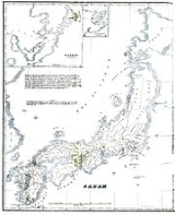
Japan
Japan is an island nation in East Asia. Located in the Pacific Ocean, it lies to the east of the Sea of Japan, China, North Korea, South Korea and Russia, stretching from the Sea of Okhotsk in the north to the East China Sea and Taiwan in the south...
are the country's 47 subnational jurisdiction
Jurisdiction
Jurisdiction is the practical authority granted to a formally constituted legal body or to a political leader to deal with and make pronouncements on legal matters and, by implication, to administer justice within a defined area of responsibility...
s: one "metropolis" (都 to), Tokyo
Tokyo
, ; officially , is one of the 47 prefectures of Japan. Tokyo is the capital of Japan, the center of the Greater Tokyo Area, and the largest metropolitan area of Japan. It is the seat of the Japanese government and the Imperial Palace, and the home of the Japanese Imperial Family...
; one "circuit" (道 dō), Hokkaidō
Hokkaido
, formerly known as Ezo, Yezo, Yeso, or Yesso, is Japan's second largest island; it is also the largest and northernmost of Japan's 47 prefectural-level subdivisions. The Tsugaru Strait separates Hokkaido from Honshu, although the two islands are connected by the underwater railway Seikan Tunnel...
; two urban prefecture
Prefecture
A prefecture is an administrative jurisdiction or subdivision in any of various countries and within some international church structures, and in antiquity a Roman district governed by an appointed prefect.-Antiquity:...
s (府 fu), Osaka
Osaka Prefecture
is a prefecture located in the Kansai region on Honshū, the main island of Japan. The capital is the city of Osaka. It is the center of Osaka-Kobe-Kyoto area.- History :...
and Kyoto
Kyoto Prefecture
is a prefecture of Japan located in the Kansai region of the island of Honshu. The capital is the city of Kyoto.- History :Until the Meiji Restoration, the area of Kyoto prefecture was known as Yamashiro....
; and 43 other prefectures (県 ken). In Japanese
Japanese language
is a language spoken by over 130 million people in Japan and in Japanese emigrant communities. It is a member of the Japonic language family, which has a number of proposed relationships with other languages, none of which has gained wide acceptance among historical linguists .Japanese is an...
, they are commonly referred to as . Prefecture
Prefecture
A prefecture is an administrative jurisdiction or subdivision in any of various countries and within some international church structures, and in antiquity a Roman district governed by an appointed prefect.-Antiquity:...
s are governmental bodies larger than cities
Cities of Japan
||A is a local administrative unit in Japan. Cities are ranked on the same level as and , with the difference that they are not a component of...
, towns
Towns of Japan
A town is a local administrative unit in Japan. It is a local public body along with prefecture , city , and village...
, and villages
Villages of Japan
A is a local administrative unit in Japan.It is a local public body along with , , and . Geographically, a village's extent is contained within a prefecture....
.
The chief executive of each prefecture is a directly elected . Ordinances and budgets are enacted by a single-chamber whose elected members serve four-year terms.
Under the current Local Autonomy Law
Local Autonomy Law
The Local Autonomy Law of Japan was passed as Law No. 67 on April 17, 1947, an Act of Devolution that established most of Japan's contemporary local government structures, including prefectures, municipalities and other entities....
, each prefecture is further subdivided into cities (市 shi) and districts (郡 gun).
Unanswered Questions