
California State Route 123
Encyclopedia
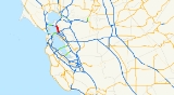
State Route 123 is a state highway
in the U.S. state
of California
in the San Francisco Bay Area
. Named San Pablo Avenue for virtually its entire length, SR 123 is a major north–south state highway along the flats of the urban East Bay in the U.S. state
of California
. Route 123 runs a relatively short 7.39 miles (11.9 km) between Interstate 580
in the south and Interstate 80 in the north. San Pablo Avenue itself, a portion of Historic US 40, continues well past these termini but without the Route 123 designation.
, Emeryville
, Berkeley
, Albany
, El Cerrito
, and Richmond
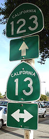
. It is sometimes used as an alternate route to the Eastshore Freeway (Interstate 80) when that freeway becomes very congested. Major intersections along this route include 40th Street, Ashby Avenue (State Route 13
), University Avenue (which leads to UC Berkeley
), Gilman Street, Marin Avenue, Central Avenue and Cutting Boulevard.
Continuing on San Pablo Avenue past Route 123's southern terminus eventually leads to downtown Oakland and Oakland City Hall where San Pablo Avenue ends. Continuing on San Pablo Avenue past Route 123's northern terminus leads to the cities of San Pablo
, Pinole
, Hercules
, Rodeo
, and Crockett
. In Hercules, San Pablo Avenue meets the terminus of State Route 4
near Interstate 80, and, after a discontinuity bridged by Parker Avenue in Rodeo, the road approaches the Carquinez Bridge
and arrives in Crockett as Pomona Street.
An AC Transit
Rapid Bus (72R-San Pablo Rapid) runs along San Pablo Ave. from Downtown Oakland to Contra Costa College
in San Pablo. The express bus line was put in place after a Metropolitan Transportation Commission
study determined that it would be more cost-effective than a previous proposal to install light rail
along the route. The BART
system runs its Richmond leg parallel
to the route up to the El Cerrito Del Norte station..
 The Alvarado Adobe is located by the San Pablo
City Hall on the corner of San Pablo Avenue and Church Lane.
and the settlement around the Mission in San Francisco) and was legally a "camino real" ("royal road", i.e., property of the Spanish crown) until Mexico won its independence in 1821. It ran from the Encinal ("Oakland") landings of the Rancho San Antonio northward (actually northwestward) along the bayshore, then eastward just inland of the Carquinez Strait
. It was the principal thoroughfare for the scattered ranches throughout this part of the East Bay.
The name persisted into the American era when it was still called the "Contra Costa Road". On July 15, 1852, the Court of Sessions
of Contra Costa County ordered the construction of a more direct and somewhat improved road along the same general route between the Rancho San Pablo
and Oakland, which consequently became known as "The San Pablo Road". This segment subsequently became today's "San Pablo Avenue".
In 1927, this road was designated as part of the Lincoln Highway
, the nation's first transcontinental road upon the opening of the new highway bridge
across the Carquinez Strait
.
Prior to the construction of the Eastshore Highway, San Pablo Avenue was the main north–south route through the northern East Bay, carrying the designation U.S. Route 40 north of University Avenue in Berkeley (US 40 proceeded down to the foot of University and the end of the Berkeley Pier
where an auto ferry transported motorists to the Hyde Street Pier
in San Francisco). U.S. 40 was moved to the new highway after it was built (1930s), and about 25 years later took its current designation of Interstate 80. San Pablo Avenue was Business U.S. 40 until 1964.
During 2005-06, San Pablo Avenue was repaved and otherwise rehabilitated by Caltrans.
Portions of San Pablo Avenue, particularly in Berkeley, Albany, and El Cerrito, are slowly transforming, with a mix of trendy shops, restaurants and condominium developments.
In the early part of the 20th century, a streetcar line ran on San Pablo between Richmond and Oakland. Part of the Oakland segment of these tracks up to Grayson Street in Berkeley were used during World War II for the Shipyard Railway
of the Key System
which transported workers from the Key System's hub in Emeryville to the Kaiser Shipyards
in Richmond.
{| class=wikitable
!County
!Location
!Postmile
!Destinations
!Notes
|-
|rowspan=6|Alameda
ALA 0.00-5.18
|rowspan=4|Oakland
|0.00
|San Pablo Avenue
|Continuation beyond I-580
|-
|0.00
|
|Interchange
|-
|
|.svg.png) MacArthur Boulevard to I-80 east
MacArthur Boulevard to I-80 east
|
|-
|1.12
| Stanford Avenue to I-80
|
|-
|rowspan=2|Berkeley
|1.91
|
|
|-
|3.15
|University Avenue
|Serves UC Berkeley
|-
|rowspan=4|Contra Costa
CC 0.00-2.20
|rowspan=2|El Cerrito
|0.29
|Central Avenue
|
|-
|2.10
|San Pablo Avenue, Cutting Boulevard
|San Pablo Avenue was former US 40 east
|-
|rowspan=2|Richmond
|2.20
|
|Interchange
|-
|2.20
|Cutting Boulevard – San Rafael
|Continuation beyond I-80
State highway
State highway, state road or state route can refer to one of three related concepts, two of them related to a state or provincial government in a country that is divided into states or provinces :#A...
in the U.S. state
U.S. state
A U.S. state is any one of the 50 federated states of the United States of America that share sovereignty with the federal government. Because of this shared sovereignty, an American is a citizen both of the federal entity and of his or her state of domicile. Four states use the official title of...
of California
California
California is a state located on the West Coast of the United States. It is by far the most populous U.S. state, and the third-largest by land area...
in the San Francisco Bay Area
San Francisco Bay Area
The San Francisco Bay Area, commonly known as the Bay Area, is a populated region that surrounds the San Francisco and San Pablo estuaries in Northern California. The region encompasses metropolitan areas of San Francisco, Oakland, and San Jose, along with smaller urban and rural areas...
. Named San Pablo Avenue for virtually its entire length, SR 123 is a major north–south state highway along the flats of the urban East Bay in the U.S. state
U.S. state
A U.S. state is any one of the 50 federated states of the United States of America that share sovereignty with the federal government. Because of this shared sovereignty, an American is a citizen both of the federal entity and of his or her state of domicile. Four states use the official title of...
of California
California
California is a state located on the West Coast of the United States. It is by far the most populous U.S. state, and the third-largest by land area...
. Route 123 runs a relatively short 7.39 miles (11.9 km) between Interstate 580
Interstate 580 (California)
Interstate 580 is an 80-mile east–west Interstate Highway in Northern California. The heavily traveled spur route of Interstate 80 runs from San Rafael in the San Francisco Bay Area to Interstate 5 near Tracy in the Central Valley...
in the south and Interstate 80 in the north. San Pablo Avenue itself, a portion of Historic US 40, continues well past these termini but without the Route 123 designation.
Route description
Route 123 is a four-lane boulevard with a median strip for its entire length. From south to north, it passes through the cities of OaklandOakland, California
Oakland is a major West Coast port city on San Francisco Bay in the U.S. state of California. It is the eighth-largest city in the state with a 2010 population of 390,724...
, Emeryville
Emeryville, California
Emeryville is a small city located in Alameda County, California, in the United States. It is located in a corridor between the cities of Berkeley and Oakland, extending to the shore of San Francisco Bay. Its proximity to San Francisco, the Bay Bridge, the University of California, Berkeley, and...
, Berkeley
Berkeley, California
Berkeley is a city on the east shore of the San Francisco Bay in Northern California, United States. Its neighbors to the south are the cities of Oakland and Emeryville. To the north is the city of Albany and the unincorporated community of Kensington...
, Albany
Albany, California
Albany is a city in Alameda County, California, United States. The population was 18,539 at the 2010 census.-History:In 1908, a group of local women protested the dumping of Berkeley garbage in their community...
, El Cerrito
El Cerrito, California
-Transportation:The city's primary transportation infrastructure consists of the El Cerrito Plaza and El Cerrito del Norte BART stations along with several local bus lines, operated by AC Transit, providing access to the surrounding area and the nearby cities of Albany, Berkeley and Richmond...
, and Richmond
Richmond, California
Richmond is a city in western Contra Costa County, California, United States. The city was incorporated on August 7, 1905. It is located in the East Bay, part of the San Francisco Bay Area. It is a residential inner suburb of San Francisco, as well as the site of heavy industry, which has been...
. It is sometimes used as an alternate route to the Eastshore Freeway (Interstate 80) when that freeway becomes very congested. Major intersections along this route include 40th Street, Ashby Avenue (State Route 13
State Route 13 (California)
State Route 13 is a state highway in California. It is a short loop in Alameda County currently built from Interstate 580 in Oakland to Interstate 80/Interstate 580 in Berkeley....
), University Avenue (which leads to UC Berkeley
University of California, Berkeley
The University of California, Berkeley , is a teaching and research university established in 1868 and located in Berkeley, California, USA...
), Gilman Street, Marin Avenue, Central Avenue and Cutting Boulevard.
Continuing on San Pablo Avenue past Route 123's southern terminus eventually leads to downtown Oakland and Oakland City Hall where San Pablo Avenue ends. Continuing on San Pablo Avenue past Route 123's northern terminus leads to the cities of San Pablo
San Pablo, California
San Pablo is a city in Contra Costa County, California, United States. The city of Richmond surrounds nearly the whole city. The population was 29,139 at the 2010 census. The current Mayor is Paul V. Morris, and the current Vice Mayor is Cecilia Valdez. Current Councilmembers include Arturo M....
, Pinole
Pinole, California
Pinole is a city in Contra Costa County, California, United States. The population was 18,390 at the 2010 census. It is one of many small “bedroom communities” along the I-80 corridor in Western Contra Costa County. It is located about northeast of San Francisco, and approximately a half-hour...
, Hercules
Hercules, California
Hercules is a city in western Contra Costa County, California. Situated along the coast of San Pablo Bay, it is located in the eastern region of the San Francisco Bay Area, about northeast of San Francisco. The city has a 2010 population of 24,060 according to the U.S...
, Rodeo
Rodeo, California
Rodeo is a census-designated place located in Contra Costa County, California on the shore of San Pablo Bay. The population was 8,679 at the 2010 census. The town is named for the livestock roundups common in the late 19th century...
, and Crockett
Crockett, California
Crockett is a census-designated place in Contra Costa County, California, United States. The population was 3,094 at the 2010 census...
. In Hercules, San Pablo Avenue meets the terminus of State Route 4
State Route 4 (California)
State Route 4 is a state highway in the U.S. state of California, routed from Interstate 80 in the San Francisco Bay Area to State Route 89 in the Sierra Nevada. It passes through Ebbetts Pass and contains the Ebbetts Pass Scenic Byway, a National Scenic Byway.SR 4 roughly parallels the...
near Interstate 80, and, after a discontinuity bridged by Parker Avenue in Rodeo, the road approaches the Carquinez Bridge
Carquinez Bridge
The Carquinez Bridge refers to parallel bridges spanning the Carquinez Strait, forming part of Interstate 80 between Crockett and Vallejo, California. The name originally referred to a single cantilever bridge built in 1927, helping to form a direct route between San Francisco and Sacramento. A...
and arrives in Crockett as Pomona Street.
An AC Transit
AC Transit
AC Transit is an Oakland-based regional public transit agency serving the western half of Alameda County and parts of western Contra Costa County in the western, Bay-side area of the East Bay of the San Francisco Bay Area...
Rapid Bus (72R-San Pablo Rapid) runs along San Pablo Ave. from Downtown Oakland to Contra Costa College
Contra Costa College
Contra Costa College, in San Pablo, California, is the west campus of the Contra Costa Community College District. It is part of the California community colleges system, one of the three college systems in California.- History :...
in San Pablo. The express bus line was put in place after a Metropolitan Transportation Commission
Metropolitan Transportation Commission (San Francisco Bay Area)
The Metropolitan Transportation Commission is a regional planning, financing, and funding government agency in the San Francisco Bay Area. It was created in 1970 to coordinate the transit systems in the area's nine counties...
study determined that it would be more cost-effective than a previous proposal to install light rail
Light rail
Light rail or light rail transit is a form of urban rail public transportation that generally has a lower capacity and lower speed than heavy rail and metro systems, but higher capacity and higher speed than traditional street-running tram systems...
along the route. The BART
Bay Area Rapid Transit
Bay Area Rapid Transit is a rapid transit system serving the San Francisco Bay Area. The heavy-rail public transit and subway system connects San Francisco with cities in the East Bay and suburbs in northern San Mateo County. BART operates five lines on of track with 44 stations in four counties...
system runs its Richmond leg parallel
Parallel (geometry)
Parallelism is a term in geometry and in everyday life that refers to a property in Euclidean space of two or more lines or planes, or a combination of these. The assumed existence and properties of parallel lines are the basis of Euclid's parallel postulate. Two lines in a plane that do not...
to the route up to the El Cerrito Del Norte station..
San Pablo, California
San Pablo is a city in Contra Costa County, California, United States. The city of Richmond surrounds nearly the whole city. The population was 29,139 at the 2010 census. The current Mayor is Paul V. Morris, and the current Vice Mayor is Cecilia Valdez. Current Councilmembers include Arturo M....
City Hall on the corner of San Pablo Avenue and Church Lane.
History
San Pablo Avenue is one of the oldest existing roads in the East Bay. It originated in the Spanish colonial era as the Camino de la Contra Costa ("road of the opposite shore", i.e. opposite from the Presidio of San FranciscoPresidio of San Francisco
The Presidio of San Francisco is a park on the northern tip of the San Francisco Peninsula in San Francisco, California, within the Golden Gate National Recreation Area...
and the settlement around the Mission in San Francisco) and was legally a "camino real" ("royal road", i.e., property of the Spanish crown) until Mexico won its independence in 1821. It ran from the Encinal ("Oakland") landings of the Rancho San Antonio northward (actually northwestward) along the bayshore, then eastward just inland of the Carquinez Strait
Carquinez Strait
The Carquinez Strait is a narrow tidal strait in northern California. It is part of the tidal estuary of the Sacramento and the San Joaquin rivers as they drain into the San Francisco Bay...
. It was the principal thoroughfare for the scattered ranches throughout this part of the East Bay.
The name persisted into the American era when it was still called the "Contra Costa Road". On July 15, 1852, the Court of Sessions
Court of Sessions (California)
The Court of Sessions system was introduced in each county of California shortly after the attainment of statehood in 1850. The Court of Sessions was largely a provisional device for governing California counties prior to the first election of boards of supervisors. Thus its powers extended beyond...
of Contra Costa County ordered the construction of a more direct and somewhat improved road along the same general route between the Rancho San Pablo
Rancho San Pablo
Rancho San Pablo was a land grant in present day Contra Costa County, California given in 1823 by Governor Luís Antonio Argüello to Francisco María Castro , a former soldier at the San Francisco Presidio and one-time alcalde of the Pueblo of San José. The grant was reconfirmed by Governor José...
and Oakland, which consequently became known as "The San Pablo Road". This segment subsequently became today's "San Pablo Avenue".
In 1927, this road was designated as part of the Lincoln Highway
Lincoln Highway
The Lincoln Highway was the first road across the United States of America.Conceived and promoted by entrepreneur Carl G. Fisher, the Lincoln Highway spanned coast-to-coast from Times Square in New York City to Lincoln Park in San Francisco, originally through 13 states: New York, New Jersey,...
, the nation's first transcontinental road upon the opening of the new highway bridge
Carquinez Bridge
The Carquinez Bridge refers to parallel bridges spanning the Carquinez Strait, forming part of Interstate 80 between Crockett and Vallejo, California. The name originally referred to a single cantilever bridge built in 1927, helping to form a direct route between San Francisco and Sacramento. A...
across the Carquinez Strait
Carquinez Strait
The Carquinez Strait is a narrow tidal strait in northern California. It is part of the tidal estuary of the Sacramento and the San Joaquin rivers as they drain into the San Francisco Bay...
.
Prior to the construction of the Eastshore Highway, San Pablo Avenue was the main north–south route through the northern East Bay, carrying the designation U.S. Route 40 north of University Avenue in Berkeley (US 40 proceeded down to the foot of University and the end of the Berkeley Pier
Berkeley Pier
The Berkeley Pier is a pier in Berkeley, California. When constructed, the pier extended 3.5 miles into San Francisco Bay from the end of University Avenue. Due to extensive filling of the bay and the creation of the Berkeley Marina, it presently extends only 2.5 miles...
where an auto ferry transported motorists to the Hyde Street Pier
Hyde Street Pier
The Hyde Street Pier is a historic ferry pier located on the northern waterfront of San Francisco, California, amidst the tourist zone of Fisherman's Wharf....
in San Francisco). U.S. 40 was moved to the new highway after it was built (1930s), and about 25 years later took its current designation of Interstate 80. San Pablo Avenue was Business U.S. 40 until 1964.
During 2005-06, San Pablo Avenue was repaved and otherwise rehabilitated by Caltrans.
Portions of San Pablo Avenue, particularly in Berkeley, Albany, and El Cerrito, are slowly transforming, with a mix of trendy shops, restaurants and condominium developments.
In the early part of the 20th century, a streetcar line ran on San Pablo between Richmond and Oakland. Part of the Oakland segment of these tracks up to Grayson Street in Berkeley were used during World War II for the Shipyard Railway
Shipyard Railway
The Shipyard Railway was an electric railroad line, rapidly constructed during World War II to transport workers to and from the Kaiser Shipyards located in the city of Richmond, California....
of the Key System
Key System
The Key System was a privately owned company which provided mass transit in the cities of Oakland, Berkeley, Alameda, Emeryville, Piedmont, San Leandro, Richmond, Albany and El Cerrito in the eastern San Francisco Bay Area from 1903 until 1960, when the system was sold to a newly formed public...
which transported workers from the Key System's hub in Emeryville to the Kaiser Shipyards
Kaiser Shipyards
The Kaiser Shipyards were seven major shipbuilding yards located mostly on the U.S. west coast during World War II. They were owned by the Kaiser Shipbuilding Company, a creation of American industrialist Henry J...
in Richmond.
Major intersections
- Note: Except where prefixed with a letter, postmiles were measured in 1964, based on the alignment as it existed at that time, and do not necessarily reflect current mileage. The numbers reset at county lines; the start and end postmiles in each county are given in the county column.
{| class=wikitable
!County
!Location
!Postmile
!Destinations
!Notes
|-
|rowspan=6|Alameda
Alameda County, California
Alameda County is a county in the U.S. state of California. It occupies most of the East Bay region of the San Francisco Bay Area. As of the 2010 census it had a population of 1,510,271, making it the 7th most populous county in the state...
ALA 0.00-5.18
|rowspan=4|Oakland
Oakland, California
Oakland is a major West Coast port city on San Francisco Bay in the U.S. state of California. It is the eighth-largest city in the state with a 2010 population of 390,724...
|0.00
|San Pablo Avenue
|Continuation beyond I-580
|-
|0.00
|
|Interchange
|-
|
|
|
|-
|1.12
|
|
|-
|rowspan=2|Berkeley
Berkeley, California
Berkeley is a city on the east shore of the San Francisco Bay in Northern California, United States. Its neighbors to the south are the cities of Oakland and Emeryville. To the north is the city of Albany and the unincorporated community of Kensington...
|1.91
|
|
|-
|3.15
|University Avenue
|Serves UC Berkeley
University of California, Berkeley
The University of California, Berkeley , is a teaching and research university established in 1868 and located in Berkeley, California, USA...
|-
|rowspan=4|Contra Costa
Contra Costa County, California
Contra Costa County is a primarily suburban county in the San Francisco Bay Area of the U.S. state of California. As of the 2010 census, it had a population of 1,049,025...
CC 0.00-2.20
|rowspan=2|El Cerrito
El Cerrito, California
-Transportation:The city's primary transportation infrastructure consists of the El Cerrito Plaza and El Cerrito del Norte BART stations along with several local bus lines, operated by AC Transit, providing access to the surrounding area and the nearby cities of Albany, Berkeley and Richmond...
|0.29
|Central Avenue
|
|-
|2.10
|San Pablo Avenue, Cutting Boulevard
|San Pablo Avenue was former US 40 east
|-
|rowspan=2|Richmond
Richmond, California
Richmond is a city in western Contra Costa County, California, United States. The city was incorporated on August 7, 1905. It is located in the East Bay, part of the San Francisco Bay Area. It is a residential inner suburb of San Francisco, as well as the site of heavy industry, which has been...
|2.20
|
|Interchange
|-
|2.20
|Cutting Boulevard – San Rafael
San Rafael, California
San Rafael is a city and the county seat of Marin County, California, United States. The city is located in the North Bay region of the San Francisco Bay Area...
|Continuation beyond I-80