
California State Route 82
Encyclopedia
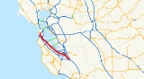
State Route 82 is a state highway
in the U.S. state
of California
that runs from U.S. Route 101 at Blossom Hill Road in San Jose
to Interstate 280
in San Francisco
following the San Francisco Peninsula
. It forms part of El Camino Real
.
 Route 82 begins its journey at US 101 and Blossom Hill Road, where it heads north onto Monterey Highway, later known as Monterey Road north of Capitol Expressway. At Alma Avenue the road becomes South First Street, and Route 82 veers onto Market Street upon approaching downtown San Jose just north of Interstate 280
(which has no direct interchange with Route 82). In less than a mile, Route 82 turns west on San Carlos Street past Downtown San Jose's hotels and convention center, then soon turns north on Montgomery Street and Autumn Street where it quickly turns again west onto The Alameda at the HP Pavilion.
Once it enters Santa Clara
, Route 82 bends northward around the city's downtown and onto El Camino Real
, where it continues for the remainder of its trip up the San Francisco Peninsula
. Route 82, referred to by local residents almost always as "El Camino," runs through a number of cities on the Peninsula, including Palo Alto
(passing by Stanford University
), San Carlos
, San Mateo
, Burlingame
, and Millbrae
, and it is a central artery of the Peninsula communities through which it passes.
In Daly City
, Route 82 becomes Mission Street, connecting with San Francisco's Mission Street
, but then quickly flows onto San Jose Avenue, crossing Alemany Boulevard
, and terminating at I-280.
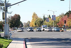
Route 82 takes an inland course paralleling the Bayshore Freeway (US 101). The entire route is at street
level with at least four lanes of traffic; no portions of it exist as a freeway, although the route is occasionally a divided highway. The Bayshore Freeway and the Interstate 280
tend to provide faster alternatives than Route 82 even during traffic jams on those freeways.
From 1964 to 1968, Route 82 continued past its current end north on Alemany Boulevard to Bayshore Boulevard in San Francisco (see below).
after World War II
, including urbanization of the towns along its path, made it completely inadequate for the needs of traffic
. The Bayshore Highway to the east was later upgraded to a freeway and was originally built as "Bypass U.S. 101".
In 1964, U.S. Route 101 was officially moved onto the Bayshore Freeway (now Route 101), and its former alignment on El Camino Real became California Route 82. It was defined as two portions: From Route 101 near Ford Road south of San Jose to Route 101 in San Francisco (which today corresponds to the Alemany Maze
), and from Route 101 near Alemany Boulevard to Route 87 (current unbuilt State Route 230) in San Francisco. In 1968, the portions from Route 280 (at current Route 82) to Route 101 and from Route 101 to Route 87 were transferred to Route 280. Route 82 today is designated as part of El Camino Real
.
{| class=wikitable
!County
!Location
!Postmile
!Destinations
!Notes
|-
|rowspan=21|Santa Clara
SCL R0.00-26.37
|rowspan=11|San Jose
|R0.00
|Silver Creek Valley Road
|Continuation beyond US 101
|-
|R0.00
|
|Interchange
|-
|R0.36
|Monterey Road, Blossom Hill Road (CR G10), Cottle Road
|Interchange
|-
|2.81
|Capitol Expressway (CR G21)
|Interchange
|-
|6.06
|
|
|-
|6.90
|
|Interchange
|-
|R7.31
|San Carlos Street, Market Street
|
|-
|R7.72
|
|Interchange
|-
|R8.08
|Bird Avenue, San Carlos Street
|
|-
|R8.61
|Santa Clara Street
|
|-
|9.90
|
|Interchange
|-
|rowspan=3|Santa Clara
|11.38
|.svg.png) De la Cruz Boulevard, Coleman Avenue to US 101
De la Cruz Boulevard, Coleman Avenue to US 101
|Interchange
|-
|
|
|
|-
|14.30
|Lawrence Expressway (CR G2)
|Interchange
|-
|Sunnyvale
|17.04
|Mathilda Avenue
|Former SR 85
|-
|rowspan=3|Mountain View
|18.84
|
|Interchange
|-
|19.13
|
|
|-
|rowspan=2|21.84
|rowspan=2|San Antonio Road
|rowspan=2|
|-
|Los Altos
|-
|rowspan=2|Palo Alto
|24.04
|
|
|-
|25.88
|Palm Drive, University Avenue – Stanford University
, Palo Alto Caltrain Station
|Interchange
|-
|rowspan=16|San Mateo
SM 0.00-25.15
|Menlo Park
|bgcolor=#ffdddd|0.77
|bgcolor=#ffdddd|Santa Cruz Avenue
|bgcolor=#ffdddd|No left turns from SR 82
|-
|Atherton
|1.89
|Atherton Avenue
|
|-
|Redwood City
|3.44
|
|Interchange
|-
|San Carlos
|6.57
|Holly Street
|
|-
|Belmont
|7.69
|Ralston Avenue
|Former Legislative Route 214
|-
|rowspan=2|San Mateo
|9.33
|Hillsdale Boulevard
|Interchange
|-
|10.55
|
|Interchange
|-
|Burlingame
|12.96
|Peninsula Avenue
|
|-
|Millbrae
|15.95
|Millbrae Avenue
|
|-
|rowspan=3|San Bruno
|18.60
|San Bruno Avenue
|
|-
|18.96
|
|Interchange
|-
|
|Sneath Lane
|
|-
|South San Francisco
|21.91
|Hickey Boulevard
|
|-
|Colma
|
|Serramonte Boulevard
|
|-
|rowspan=2|Daly City
|24.85
|John Daly Boulevard, Hillside Boulevard
|
|-
|24.93
|Mission Street
|
|-
|rowspan=3 colspan=2|San Francisco
SF 0.00-R0.21
|bgcolor=#ffdddd|
|bgcolor=#ffdddd|Alemany Boulevard
|bgcolor=#ffdddd|Former SR 82 north; no left turn from SR 82 south to Alemany Boulevard
|-bgcolor=#ffdddd
|R0.21
|
|Interchange; northbound exit and southbound entrance
|-
|R0.21
|San Jose Avenue
|Continuation beyond I-280
State highway
State highway, state road or state route can refer to one of three related concepts, two of them related to a state or provincial government in a country that is divided into states or provinces :#A...
in the U.S. state
U.S. state
A U.S. state is any one of the 50 federated states of the United States of America that share sovereignty with the federal government. Because of this shared sovereignty, an American is a citizen both of the federal entity and of his or her state of domicile. Four states use the official title of...
of California
California
California is a state located on the West Coast of the United States. It is by far the most populous U.S. state, and the third-largest by land area...
that runs from U.S. Route 101 at Blossom Hill Road in San Jose
San Jose, California
San Jose is the third-largest city in California, the tenth-largest in the U.S., and the county seat of Santa Clara County which is located at the southern end of San Francisco Bay...
to Interstate 280
Interstate 280 (California)
Interstate 280 is a 57-mile long north–south Interstate Highway in the San Francisco Bay Area of Northern California. It connects San Jose and San Francisco, running along just to the west of the cities of San Francisco Peninsula for most of its route.I-280 from its northern end at King...
in San Francisco
San Francisco, California
San Francisco , officially the City and County of San Francisco, is the financial, cultural, and transportation center of the San Francisco Bay Area, a region of 7.15 million people which includes San Jose and Oakland...
following the San Francisco Peninsula
San Francisco Peninsula
The San Francisco Peninsula is a peninsula in the San Francisco Bay Area that separates the San Francisco Bay from the Pacific Ocean. On its northern tip is the City and County of San Francisco. Its southern base is in Santa Clara County, including the cities of Palo Alto, Los Altos, and Mountain...
. It forms part of El Camino Real
El Camino Real (California)
El Camino Real and sometimes associated with Calle Real usually refers to the 600-mile California Mission Trail, connecting the former Alta California's 21 missions , 4 presidios, and several pueblos, stretching from Mission San Diego de Alcalá in San Diego...
.
Route description
Interstate 280 (California)
Interstate 280 is a 57-mile long north–south Interstate Highway in the San Francisco Bay Area of Northern California. It connects San Jose and San Francisco, running along just to the west of the cities of San Francisco Peninsula for most of its route.I-280 from its northern end at King...
(which has no direct interchange with Route 82). In less than a mile, Route 82 turns west on San Carlos Street past Downtown San Jose's hotels and convention center, then soon turns north on Montgomery Street and Autumn Street where it quickly turns again west onto The Alameda at the HP Pavilion.
Once it enters Santa Clara
Santa Clara, California
Santa Clara , founded in 1777 and incorporated in 1852, is a city in Santa Clara County, in the U.S. state of California. The city is the site of the eighth of 21 California missions, Mission Santa Clara de Asís, and was named after the mission. The Mission and Mission Gardens are located on the...
, Route 82 bends northward around the city's downtown and onto El Camino Real
El Camino Real (California)
El Camino Real and sometimes associated with Calle Real usually refers to the 600-mile California Mission Trail, connecting the former Alta California's 21 missions , 4 presidios, and several pueblos, stretching from Mission San Diego de Alcalá in San Diego...
, where it continues for the remainder of its trip up the San Francisco Peninsula
San Francisco Peninsula
The San Francisco Peninsula is a peninsula in the San Francisco Bay Area that separates the San Francisco Bay from the Pacific Ocean. On its northern tip is the City and County of San Francisco. Its southern base is in Santa Clara County, including the cities of Palo Alto, Los Altos, and Mountain...
. Route 82, referred to by local residents almost always as "El Camino," runs through a number of cities on the Peninsula, including Palo Alto
Palo Alto, California
Palo Alto is a California charter city located in the northwest corner of Santa Clara County, in the San Francisco Bay Area of California, United States. The city shares its borders with East Palo Alto, Mountain View, Los Altos, Los Altos Hills, Stanford, Portola Valley, and Menlo Park. It is...
(passing by Stanford University
Stanford University
The Leland Stanford Junior University, commonly referred to as Stanford University or Stanford, is a private research university on an campus located near Palo Alto, California. It is situated in the northwestern Santa Clara Valley on the San Francisco Peninsula, approximately northwest of San...
), San Carlos
San Carlos, California
San Carlos is a city in San Mateo County, California, USA on the San Francisco Peninsula, about halfway between San Francisco and San Jose. It is an affluent small residential suburb located between Belmont to the north and Redwood City to the south. San Carlos' ZIP code is 94070, and it is within...
, San Mateo
San Mateo, California
San Mateo is a city in San Mateo County, California, United States, in the San Francisco Bay Area. With a population of approximately 100,000 , it is one of the larger suburbs on the San Francisco Peninsula, located between Burlingame to the north, Foster City to the east, Belmont to the south,...
, Burlingame
Burlingame, California
Burlingame is a city in San Mateo County, California. It is located on the San Francisco Peninsula and has a significant shoreline on San Francisco Bay. The city is named after diplomat Anson Burlingame. It is renowned for its many surviving examples of Victorian architecture, its affluence, and...
, and Millbrae
Millbrae, California
Millbrae is a city in San Mateo County, California, United States, just west of San Francisco Bay, with San Bruno on the north and Burlingame on the south. The population was 21,532 at the 2010 census.-History:...
, and it is a central artery of the Peninsula communities through which it passes.
In Daly City
Daly City, California
Daly City is the largest city in San Mateo County, California, United States, with a 2010 population of 101,123. Located immediately south of San Francisco, it is named in honor of businessman and landowner John Daly.-History:...
, Route 82 becomes Mission Street, connecting with San Francisco's Mission Street
Mission Street
Mission Street is a north-south arterial thoroughfare in San Francisco, California that runs from the city's southern border to its northeast corner. The street and the Mission District through which it runs were named for the Spanish Mission Dolores, several blocks away from the modern route. Only...
, but then quickly flows onto San Jose Avenue, crossing Alemany Boulevard
Alemany Boulevard
Alemany Boulevard is an east–west street in San Francisco, California. The boulevard was named for Archbishop Joseph Sadoc Alemany, the first bishop of the Roman Catholic Archdiocese of San Francisco....
, and terminating at I-280.
Route 82 takes an inland course paralleling the Bayshore Freeway (US 101). The entire route is at street
Street
A street is a paved public thoroughfare in a built environment. It is a public parcel of land adjoining buildings in an urban context, on which people may freely assemble, interact, and move about. A street can be as simple as a level patch of dirt, but is more often paved with a hard, durable...
level with at least four lanes of traffic; no portions of it exist as a freeway, although the route is occasionally a divided highway. The Bayshore Freeway and the Interstate 280
Interstate 280 (California)
Interstate 280 is a 57-mile long north–south Interstate Highway in the San Francisco Bay Area of Northern California. It connects San Jose and San Francisco, running along just to the west of the cities of San Francisco Peninsula for most of its route.I-280 from its northern end at King...
tend to provide faster alternatives than Route 82 even during traffic jams on those freeways.
From 1964 to 1968, Route 82 continued past its current end north on Alemany Boulevard to Bayshore Boulevard in San Francisco (see below).
History
Originally a segment of U.S. Route 101 (and before that, the historic El Camino Real), rapid growth of the San Francisco Bay AreaSan Francisco Bay Area
The San Francisco Bay Area, commonly known as the Bay Area, is a populated region that surrounds the San Francisco and San Pablo estuaries in Northern California. The region encompasses metropolitan areas of San Francisco, Oakland, and San Jose, along with smaller urban and rural areas...
after World War II
World War II
World War II, or the Second World War , was a global conflict lasting from 1939 to 1945, involving most of the world's nations—including all of the great powers—eventually forming two opposing military alliances: the Allies and the Axis...
, including urbanization of the towns along its path, made it completely inadequate for the needs of traffic
Traffic
Traffic on roads may consist of pedestrians, ridden or herded animals, vehicles, streetcars and other conveyances, either singly or together, while using the public way for purposes of travel...
. The Bayshore Highway to the east was later upgraded to a freeway and was originally built as "Bypass U.S. 101".
In 1964, U.S. Route 101 was officially moved onto the Bayshore Freeway (now Route 101), and its former alignment on El Camino Real became California Route 82. It was defined as two portions: From Route 101 near Ford Road south of San Jose to Route 101 in San Francisco (which today corresponds to the Alemany Maze
Alemany Maze
Alemany Maze is the name given to the interchange between the James Lick Freeway and the John F. Foran Freeway in the city of San Francisco...
), and from Route 101 near Alemany Boulevard to Route 87 (current unbuilt State Route 230) in San Francisco. In 1968, the portions from Route 280 (at current Route 82) to Route 101 and from Route 101 to Route 87 were transferred to Route 280. Route 82 today is designated as part of El Camino Real
El Camino Real (California)
El Camino Real and sometimes associated with Calle Real usually refers to the 600-mile California Mission Trail, connecting the former Alta California's 21 missions , 4 presidios, and several pueblos, stretching from Mission San Diego de Alcalá in San Diego...
.
Major intersections
- Note: Except where prefixed with a letter, postmiles were measured in 1964, based on the alignment as it existed at that time, and do not necessarily reflect current mileage. The numbers reset at county lines; the start and end postmiles in each county are given in the county column.
{| class=wikitable
!County
!Location
!Postmile
!Destinations
!Notes
|-
|rowspan=21|Santa Clara
Santa Clara County, California
Santa Clara County is a county located at the southern end of the San Francisco Bay Area in the U.S. state of California. As of 2010 it had a population of 1,781,642. The county seat is San Jose. The highly urbanized Santa Clara Valley within Santa Clara County is also known as Silicon Valley...
SCL R0.00-26.37
|rowspan=11|San Jose
San Jose, California
San Jose is the third-largest city in California, the tenth-largest in the U.S., and the county seat of Santa Clara County which is located at the southern end of San Francisco Bay...
|R0.00
|Silver Creek Valley Road
|Continuation beyond US 101
|-
|R0.00
|
|Interchange
|-
|R0.36
|Monterey Road, Blossom Hill Road (CR G10), Cottle Road
|Interchange
|-
|2.81
|Capitol Expressway (CR G21)
|Interchange
|-
|6.06
|
|
|-
|6.90
|
|Interchange
|-
|R7.31
|San Carlos Street, Market Street
|
|-
|R7.72
|
|Interchange
|-
|R8.08
|Bird Avenue, San Carlos Street
|
|-
|R8.61
|Santa Clara Street
|
|-
|9.90
|
|Interchange
|-
|rowspan=3|Santa Clara
Santa Clara, California
Santa Clara , founded in 1777 and incorporated in 1852, is a city in Santa Clara County, in the U.S. state of California. The city is the site of the eighth of 21 California missions, Mission Santa Clara de Asís, and was named after the mission. The Mission and Mission Gardens are located on the...
|11.38
|
|Interchange
|-
|
|
|
|-
|14.30
|Lawrence Expressway (CR G2)
|Interchange
|-
|Sunnyvale
Sunnyvale, California
Sunnyvale is a city in Santa Clara County, California, United States. It is one of the major cities that make up the Silicon Valley located in the San Francisco Bay Area...
|17.04
|Mathilda Avenue
|Former SR 85
California State Route 85
State Route 85 is a freeway which connects Mountain View and southern San Jose. The entire freeway is named the West Valley Freeway. The majority of the route is also named the Norman Y. Mineta Highway, with the exception of the portion of Highway 85 passing through Saratoga which is named the CHP...
|-
|rowspan=3|Mountain View
Mountain View, California
-Downtown:Mountain View has a pedestrian-friendly downtown centered on Castro Street. The downtown area consists of the seven blocks of Castro Street from the Downtown Mountain View Station transit center in the north to the intersection with El Camino Real in the south...
|18.84
|
|Interchange
|-
|19.13
|
|
|-
|rowspan=2|21.84
|rowspan=2|San Antonio Road
|rowspan=2|
|-
|Los Altos
Los Altos, California
Los Altos is a city at the southern end of the San Francisco Peninsula, in the San Francisco Bay Area. The city is in Santa Clara County, California, United States. The population was 28,976 according to the 2010 census....
|-
|rowspan=2|Palo Alto
Palo Alto, California
Palo Alto is a California charter city located in the northwest corner of Santa Clara County, in the San Francisco Bay Area of California, United States. The city shares its borders with East Palo Alto, Mountain View, Los Altos, Los Altos Hills, Stanford, Portola Valley, and Menlo Park. It is...
|24.04
|
|
|-
|25.88
|Palm Drive, University Avenue – Stanford University
Stanford University
The Leland Stanford Junior University, commonly referred to as Stanford University or Stanford, is a private research university on an campus located near Palo Alto, California. It is situated in the northwestern Santa Clara Valley on the San Francisco Peninsula, approximately northwest of San...
, Palo Alto Caltrain Station
|Interchange
|-
|rowspan=16|San Mateo
San Mateo County, California
San Mateo County is a county located in the San Francisco Bay Area of the U.S. state of California. It covers most of the San Francisco Peninsula just south of San Francisco, and north of Santa Clara County. San Francisco International Airport is located at the northern end of the county, and...
SM 0.00-25.15
|Menlo Park
Menlo Park, California
Menlo Park, California is a city at the eastern edge of San Mateo County, in the San Francisco Bay Area of California, in the United States. It is bordered by San Francisco Bay on the north and east; East Palo Alto, Palo Alto, and Stanford to the south; Atherton, North Fair Oaks, and Redwood City...
|bgcolor=#ffdddd|0.77
|bgcolor=#ffdddd|Santa Cruz Avenue
|bgcolor=#ffdddd|No left turns from SR 82
|-
|Atherton
Atherton, California
Atherton is an incorporated town in San Mateo County, California, United States. Its population was 6,914 at the 2010 census. In September 2010, Forbes magazine placed Atherton's zip code of 94027 at #2 on its annual list of America's most expensive zip codes, with a median home price of $4,010,200...
|1.89
|Atherton Avenue
|
|-
|Redwood City
Redwood City, California
Redwood City is a California charter city located on the San Francisco Peninsula in Northern California, approximately 27 miles south of San Francisco, and 24 miles north of San Jose. Redwood City's history spans from its earliest inhabitation by the Ohlone people, to its tradition as a port for...
|3.44
|
|Interchange
|-
|San Carlos
San Carlos, California
San Carlos is a city in San Mateo County, California, USA on the San Francisco Peninsula, about halfway between San Francisco and San Jose. It is an affluent small residential suburb located between Belmont to the north and Redwood City to the south. San Carlos' ZIP code is 94070, and it is within...
|6.57
|Holly Street
|
|-
|Belmont
Belmont, California
Belmont is a city in San Mateo County, California, United States. It is in the San Francisco Bay Area, located half-way down the San Francisco Peninsula between San Mateo and San Carlos. It was originally part of the Rancho de las Pulgas, for which one of its main roads, the Alameda de las Pulgas,...
|7.69
|Ralston Avenue
|Former Legislative Route 214
|-
|rowspan=2|San Mateo
San Mateo, California
San Mateo is a city in San Mateo County, California, United States, in the San Francisco Bay Area. With a population of approximately 100,000 , it is one of the larger suburbs on the San Francisco Peninsula, located between Burlingame to the north, Foster City to the east, Belmont to the south,...
|9.33
|Hillsdale Boulevard
|Interchange
|-
|10.55
|
|Interchange
|-
|Burlingame
Burlingame, California
Burlingame is a city in San Mateo County, California. It is located on the San Francisco Peninsula and has a significant shoreline on San Francisco Bay. The city is named after diplomat Anson Burlingame. It is renowned for its many surviving examples of Victorian architecture, its affluence, and...
|12.96
|Peninsula Avenue
|
|-
|Millbrae
Millbrae, California
Millbrae is a city in San Mateo County, California, United States, just west of San Francisco Bay, with San Bruno on the north and Burlingame on the south. The population was 21,532 at the 2010 census.-History:...
|15.95
|Millbrae Avenue
|
|-
|rowspan=3|San Bruno
San Bruno, California
San Bruno is a city in San Mateo County, California, United States. The population was 41,114 at the 2010 census.The city is adjacent to San Francisco International Airport and Golden Gate National Cemetery.-Geography:San Bruno is located at...
|18.60
|San Bruno Avenue
|
|-
|18.96
|
|Interchange
|-
|
|Sneath Lane
|
|-
|South San Francisco
South San Francisco, California
South San Francisco is a city in San Mateo County, California, United States, located on the San Francisco Peninsula in the San Francisco Bay Area...
|21.91
|Hickey Boulevard
|
|-
|Colma
Colma, California
Colma is a small incorporated town in San Mateo County, California, at the northern end of the San Francisco Peninsula in the San Francisco Bay Area. The population was 1,792 at the 2010 census. The town was founded as a necropolis in 1924....
|
|Serramonte Boulevard
|
|-
|rowspan=2|Daly City
Daly City, California
Daly City is the largest city in San Mateo County, California, United States, with a 2010 population of 101,123. Located immediately south of San Francisco, it is named in honor of businessman and landowner John Daly.-History:...
|24.85
|John Daly Boulevard, Hillside Boulevard
|
|-
|24.93
|Mission Street
Mission Street
Mission Street is a north-south arterial thoroughfare in San Francisco, California that runs from the city's southern border to its northeast corner. The street and the Mission District through which it runs were named for the Spanish Mission Dolores, several blocks away from the modern route. Only...
|
|-
|rowspan=3 colspan=2|San Francisco
San Francisco, California
San Francisco , officially the City and County of San Francisco, is the financial, cultural, and transportation center of the San Francisco Bay Area, a region of 7.15 million people which includes San Jose and Oakland...
SF 0.00-R0.21
|bgcolor=#ffdddd|
|bgcolor=#ffdddd|Alemany Boulevard
Alemany Boulevard
Alemany Boulevard is an east–west street in San Francisco, California. The boulevard was named for Archbishop Joseph Sadoc Alemany, the first bishop of the Roman Catholic Archdiocese of San Francisco....
|bgcolor=#ffdddd|Former SR 82 north; no left turn from SR 82 south to Alemany Boulevard
|-bgcolor=#ffdddd
|R0.21
|
|Interchange; northbound exit and southbound entrance
|-
|R0.21
|San Jose Avenue
|Continuation beyond I-280
See also
- El Camino Real (California)El Camino Real (California)El Camino Real and sometimes associated with Calle Real usually refers to the 600-mile California Mission Trail, connecting the former Alta California's 21 missions , 4 presidios, and several pueblos, stretching from Mission San Diego de Alcalá in San Diego...
- U.S. Route 101
- State Route 72, Route 82's sister route in Southern CaliforniaSouthern CaliforniaSouthern California is a megaregion, or megapolitan area, in the southern area of the U.S. state of California. Large urban areas include Greater Los Angeles and Greater San Diego. The urban area stretches along the coast from Ventura through the Southland and Inland Empire to San Diego...
.