

Effects of the 2009 Pacific typhoon season in the Philippines
Encyclopedia
The effects of the 2009 Pacific typhoon season
in the Philippines
were considered some of the worst in decades. Throughout the year, series of typhoons impacted the country, with the worst damage occurring during September and October from Typhoons Ketsana and Parma.
in early January, forcing 38,764 people to evacuate to shelters from their homes. The flooding destroyed 294 houses, killed two people, and left nine others missing. About 12,211 people were left stranded at ports due to dangerous conditions caused by the depression. An additional 14 trucks, 44 light cars, 75 passenger buses, 27 vessels and 295 rolling cargoes were also stranded. A total of 305 homes were destroyed and another 610 were damaged. In addition, an estimated 53 hectares (130.9 acres) of rice and 3.5 hectares (8.6 acres) of corn were damaged. About 43,851 people were affected by the depression and damages from the depression were estimated at PHP
23 million ($498,318 US$).
Late on February 14, the remnants of Tropical Depression Bising brought scattered rainshowers across Southern Luzon
, Bicol Region
, and Visayas
, then dissipated. The rainfall led to mudslides on Cebu Island
which blocked the Cebu Transcentral Highway. Heavy rains produced by the outer bands
of Tropical Depression Crising caused flooding in western areas of the Philippines, affecting an estimated 2,500 people. The worst flooding occurred in Lucena City
where ten villages were isolated. Areas along the Bucon and Inalmasinan Rivers were inundated and sustained significant crop losses. Several animals reportedly drowned in the region. Several roads were impassable due to landslides or were washed out by floodwaters. One bridge was destroyed in the town of Mercedes.
, Cagayan
, Apayao
, Ilocos Norte
, Aurora (further, these provinces received more than 200mm in 24 hours.) and Zambales
(received more than 135 mm in 24 hours). Rain was also heavy over Pampanga
(receiving 145 mm), Nueva Ecija
, Tarlac
, Bulacan
, Bataan
, Metro Manila
and parts of southern Luzon. Moderate rain was also experienced over Quezon
province and Bicol Region
. (Cagayan and Isabela are not specified but are also flooded which can mean it may have experienced more than 50 mm of rain. Moreover, Cagayan River
flooded). As of May 10, about 65,000 thousand people were left homeless in Ilocos Region
and in Cordillera region
.
 In Bataan
, the flood was up to the waistline. Some residents were also evacuated. As of May 8, at least 25 people were confirmed to have been killed by flooding and mudslides produced by Emong. Chan-hom further affected 4,000 people, caused 11 landslides, cost PHP
863,528 worth of crops in 55 hectares of land in Zambales
and PHP4.4 million worth of transmission lines in Pangasinan
.
On May 9, the number of fatalities increased to 26. Western Pangasinan was put under a state of calamity, with the whole province registering at least 16 deaths. Deaths included those who drowned, buried under their collapsed homes and got hit by flying debris. In the town of Anda
in Pangasinan, "90 percent" of houses got their roofs blown away, with mango trees uprooted and cultured fishes washed away to the sea. In Ifugao, at least 10 deaths were blamed on landslides, while the bridges linking Lamut
and Bagabag, Nueva Vizcaya
collapsed. In Isabela, "all work animals" in San Mateo
drowned when the town river overflowed.
The National Disaster Coordinating Council (NDCC) damage report update on 6:00 pm May 19 put dead at 60, injured at 53 and missing at 13 and damage worth 1,280,897,383 pesos of which 750,403,562 were in agriculture and 530,493,821 in infrastructure. It further affected 385,833 persons living in 615 barangays of 59 municipalities and 7 cities of 12 provinces of Region I (La Union and Pangasinan), Region II (Nueva Vizcaya, Isabela, Quirino and Cagayan), Region III (Zambales and Pampanga) and Cordillera Administrative Region (Ifugao, Kalinga, Mountain Province and Benguet) as well as damaged 56,160 houses of which 23,444 are totally destroyed and 32,716 partially damaged, and induced 11 landslides in Zambales and Ifugao.
of Nangka. In San Pascual, Bauan and Batangas City, large hail fell during a strong storm. Residents reported that they have never seen hail before. In Barangay, 4 in Bauan town, a rare tornado struck, downing several trees, damaging homes and signs. Heavy rains produced by the storm also flooded numerous regions, some reporting waist-deep water. Later reports confirmed the tornado destroyed 23 homes. In Cebu, one person was killed and seven were left missing. At least 500 people were also left homeless due to the storm. In Cavite,7000 was stranded on the port due to Nangka's winds and heavy rains. about 4 feet (1.2 m) is the water wave in Cavite. In Albay
, more than 300 ship passengers were also stranded at the Albay port, Tabaco, Albay. In Navotas and Malabon, the Navotas – Malabon river produced a 3 foot (0.9144 m) high tide in the area.
As of June 24, Nangka (Feria) has caused 6 deaths and left 11 people missing. Property damage from the storm is estimated at PHP 2.8 million (US$54,000).
In response to Tropical Storm Soudelor, the Philippine Atmospheric, Geophysical and Astronomical Services Administration
issued public storm signal one for nine regions of the northern Philippines. As a tropical depression, Soudelor brushed northern Luzon
in the Philippines, producing upwards of 330 mm (13 in) of rainfall which resulted in flash flooding and landslides. In Ilocos Norte
, major roadways were completely blocked by high waters. The storm affected 19,845 people throughout the Philippines and one person was killed after being swept away by a fast current. At least ten villages were flooded during the storm. Three homes were destroyed and two more were damaged by Soudelor. A total of 42 barangays were flooded by the storm, killing 21 cows and isolating low-lying areas. On July 10, a battalion from the army engineers were deployed to the affected region to repair infrastructure. Following the storm, the hardest hit town Bacarra, Ilocos Norte
, was put under a state of calamity and regional aid was deployed to the area.
In the Philippines Goni (Jolina) death toll is 8 with 5 more missing. Goni (Jolina) affected 38,589 families or 160,038 people in 119 villages in 25 towns and five cities in Ilocos Sur
, Batangas
, Cagayan
, Nueva Ecija
, Rizal
, Mindoro Occidental, Palawan
, Iloilo
, Negros Occidental
, Lanao del Sur
, and Sultan Kudarat town in Maguindanao
.
, ten villages (Paudpod, San Juan, Batonloc, Carael, Tampo, Paco, San Miguel, Bining, Bangan, and Capayawan) have been submerged in 4 to 5 ft (1.2 to 1.5 m) floods after the Pinatubo Dike overflowed. Joint military and police rescue teams rescued 3 Koreans and 9 Canadian nationals. About 30,000 families were affected by Morakot; eleven people are confirmed dead. Three French tourists and two Filipino guides were killed in a flashflood caused by a landslide. Thousands are trapped on rooftops or in trees awaiting helicopter rescue attempts and thousands have lost their homes. At least two have died from flooding. Landslides have claimed the lives of two children and five miners are still missing after a landslide destroyed their huts. Schools have suspended their classes in the hardest hit area, and highways have been closed due to landslides.
In western Luzon including Manila, a 48 hour rainfall were recorded upon the formation of Tropical Storm Mujigae as a depression. The depression enhanced the southwest monsoon that brought torrential rains in the area. In Laguna, two children were killed due to landslides caused by torrential rains brought by Maring. Late on September 8, both the JMA and the PAGASA declared the system was a minor tropical depression. Also, on September 9, all classes in Manila was suspended from Pre – school, Elementary school, and High school due to incessant raining and flooding. The National Disaster Coordinating Council reported that at least three villages in Malabon City were submerged in 18 inches (457.2 mm) floodwaters. At least four streets in the area were impassable to light vehicles. Also on that day, six provinces was raised in public storm signal no. 1.
In Valenzuela City, 15 low-lying barangays located in the city’s first district are underwater. In Bulacan, five towns and two cities of the province are flooded, with water as high as four feet. In Bataan, the town of Dinalupihan was placed under state of calamity after 22 barangays were affected by flash floods. In Pampanga, the NDCC placed the towns of Sta.Ana, San Luis, Minalin, Mexico, Macabebe, Masantol, Apalit, Guagua, Sasmuan, Lubao, and Bacolor in state of calamity due of rivers in Tarlac are swelling.
More than 300, 000 residents of four northern provinces were affected by floods, including about 3,300 people who fled to evacuation centers and more than 41,000 who moved in with their relatives and friends. Overall damages were estimated of 25 million Philippine Peso
in agricultural land.
and Philippine Coast Guard
dispatched teams to rescue stranded and trapped people. At that time, flood average was from two-feet to waist high, and in some areas are more than six feet.
The resulting landslides and severe flooding left at least 246 people dead and 38 others missing. Public and private roads were clogged by vehicles stuck in floodwater. Thousands of motorists and more than 500 passengers were stranded at the North Luzon Expressway
(NLEx). Distress calls and e-mails from thousands of Metro Manila and their worried relatives flooded TV and radio stations overnight as most of the power, communication and water lines were lost. Ketsana also caused the shutting down of flights and operations at the Ninoy Aquino International Airport
for almost a day.
The economic region of Metro Manila
and many adjoining provinces incurred damages to both infrastructure
and agriculture. Total damage of Ketsana as of September 28, 2009 is estimated at $100 million. Internet café
s, entertainment plazas, banks, food stores, building agencies and stores were soaked into flood and mud.
Compared to other storm-hit areas in the Philippines
, Marikina City
, was the most devastated region where almost all of the city's area was submerged in water not more than ten feet and tons of knee-deep mud. During the typhoon, Marikina River
broke off from its banks and transformed streets into rivers of flood. The breakage of the river from its dike causes heavy flooding on other Metro Manila streets. Marikina residential areas, particularly Provident Village, was highly spawned by flood were at least eight people were found dead. Marikina itself recorded 78 deaths, the highest among Metro Manila cities.
At the height of the flooding, around 100,000 liters bunker oil from the paper manufacturing firm Noah's Paper Mill in Marikina City
spilled when pressurized by the surge. Most of the oil battered the city's barangay
s and small comparable amount combined with the Marikina River
and basement of SM City Marikina
. The spill will later complicate rescue efforts in the city. On September 29, National Power Corporation Flood Forecasting and Warning System
released 500 cubic meters of stored water from the Angat Dam
in Bulacan
over a two day period. The dam accumulated 100 cubic meters of water when Ketsana hit the province.
In Mindanao
, several towns in Cotabato City
and nearby Sultan Kudarat municipalities were submerged. The closing of national highway in Bulalo, Cotabato City led to the isolation of connecting towns for several days.
On September 28, an 11 am advisory of PAG-ASA was issued canceling all public storm signals in the country when Ketsana left Philippine Area of Responsibility.
, where the first signal warning no.3 was raised, the province's power and communications were cut. Fallen trees were already in the main roads. About 30,000 families were evacuated. In addition also to the Bicol
region, more than 2,000 passengers were stranded in ferry stations. 39 provinces including Metro Manila were put to signal warnings, with each place experienced massive rainfall with strong winds. Parma made its landfall at Northeastern Cagayan at 3:00 pm PST/07:00 (UTC)In Cagayan
, at least 6,036 people in 39 barangays (villages) were affected, while P20.33 million worth of agricultural produce were destroyed. Also, in the Chico River was swelled due to the typhoon, making the Maguilling Overflow Bridge along the Cagayan-Apayao Road impassable. The Maharlika Highway in Ilagan, Isabela to Cagayan became hardly passable due to the trees and electric posts that fell when Pepeng battered the area. Total power interruption also crippled the provinces of Kalinga, Apayao, and the northern towns of Isabela. In Kalinga, landslides were reported on roads linking the provincial capital, Tabuk, to upland towns. In Zambales, at least 2,100 families were evacuated as Pepeng brought heavy rains causing the Bucao River to swell. The Carael section of the Zambales highway became impassable due to rising floodwaters. Due to heavy downpour, the San Roque Dam
in Eastern Pangasinan
and Pantabangan Dam
in Nueva Ecija
was forced to release huge amount of water. It caused flooding in Eastern and Central Pangasinan as well as Nueva Ecija. In Metro Manila
the area is still experienced torrential rains and strong winds. Floodwaters continue to rise in some areas in Metro Manila and Calabarzon
. In Pateros
, Muntinlupa, and Taguig, in Taytay
town in Rizal province, and in the towns of Biñan and San Pedro
in Laguna
province, the flood is not subsiding. The Laguna de Bay
is breaking a 90-year record in meters of water, which threatens to submerge more areas in Metro Manila. In Benguet
, a landslide killed at least 200 as Tropical Depression Parma continues to bring rain across northern Luzon
. by jhennivie
While Parma (Pepeng) was still drifting over northern Luzon, Melor
entered PAGASA's area of responsibility, and therefore was named Quedan. While it did not make lanfall on any part of the country, its interaction with Typhoon Parma would cause Melor to weaken and shift course to Japan while Parma crossed Northern Luzon three times, therefore bringing rain, wind and destruction over the area.
Lupit (Ramil) was the next typhoon to directly hit any part of the Philippines, having threatened the areas already ravaged by Typhoon Parma. While initially forecasted by PAGASA to cross Cagayan or Batanes by, Ramil eventually veered northeast in spite of strengthening, sparing the areas still recovering from Pepeng's wrath. However, it brought little to moderate rain from Cagayan to as far as Southern Luzon. Despite this incident, local governments in Northern Luzon prepared for the worst, even putting medical personnel on "Code Blue" (on-duty 24/7) and having Army contingents sent out by the national government It also forced planes and buses, especially those going north, to suspend trips. Dams also released water, exactly like when Parma hit the area.
Mirinae (Santi)
was the last significant storm to make landfall on any part of the country. It took the similar direction that Ondoy went through as it wreaked havoc over Philippines, and therefore again hitting the capital Manila and nearby provinces. Hitting just before the Philippine holiday, All Saints' Day, it went through Quezon Province, Batangas
and Cavite
. It lashed strong winds, rain, and added some more damage to the areas still recovering from Ondoy, especially flooded areas in Rizal Province and Laguna. But its passage is rather quick; this spared the affected areas from further devastation; however, it left at least 13 dead. Dams also released water, like what happened when Parma hit Northern Luzon. Power outages became widespread especially over Manila as Santi was over Southern Tagalog region; they were subsequently restored
Tropical depression Urduja brought torrential rain over Visayas, killing four people and making roads impassable over the affected areas.
Tropical depression Tino and Typhoon Nida (Vinta)
were observed over PAGASA's area of responsibility, but did little to no damage.
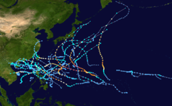
2009 Pacific typhoon season
The 2009 Pacific typhoon season was the period that tropical cyclones formed in the Western Pacific Ocean. The season ran throughout the year during 2009, with most tropical cyclones forming between May and November. The scope of this article is limited to the Pacific Ocean, north of the equator...
in the Philippines
Philippines
The Philippines , officially known as the Republic of the Philippines , is a country in Southeast Asia in the western Pacific Ocean. To its north across the Luzon Strait lies Taiwan. West across the South China Sea sits Vietnam...
were considered some of the worst in decades. Throughout the year, series of typhoons impacted the country, with the worst damage occurring during September and October from Typhoons Ketsana and Parma.
Seasonal activity
| Name | PAGASA name |
Dates of impact | Fatalities | Damages (Millions US$) |
Maximum intensity during passage |
|---|---|---|---|---|---|
| ---- | Auring Tropical Depression Auring (2009) Tropical Depression Auring formed as a tropical disturbance late on December 30, 2008, to the southeast of Manila in the Philippines. Over the next few days the disturbance gradually developed before early on January 3, the Philippine Atmospheric, Geophysical and Astronomical Services... |
|
|
|
|
| ---- | Bising | |
|
|
|
| ---- | Crising | |
|
|
|
| Kujira Typhoon Kujira (2009) Typhoon Kujira was first reported by the Joint Typhoon Warning Center on April 28. It is the fourth depression and the first typhoon of the season.The disturbance dissipated later that day however it regenerated early on April 30 within the southern islands of Luzon... |
Dante | |
|
|
|
| Chan-hom Typhoon Chan-hom (2009) Typhoon Chan-hom is the sixth tropical depression or the second tropical storm to develop during the 2009 Pacific typhoon season... |
Emong | |
|
|
|
| Nangka | Feria | |
|
|
|
| Soudelor Tropical Storm Soudelor (2009) Tropical Storm Soudelor was a weak tropical cyclone that produced deadly flooding in the Philippines, China and Vietnam. Forming out of an area of low pressure on July 9, Soudelor failed to maintain deep convection around its center for the duration of its existence... |
Gorio | |
|
|
|
| 06W | Huaning | |
|
|
|
| Molave | Isang | |
|
|
|
| Goni | Jolina | |
|
|
|
| Morakot Typhoon Morakot (2009) Typhoon Morakot was the deadliest typhoon to impact Taiwan in recorded history. It formed early on August 2, 2009 as an unnamed tropical depression... |
Kiko | |
|
|
|
| Dujuan | Labuyo | |
|
|
|
| Mujigae Tropical Storm Mujigae (2009) Tropical Storm Mujigae formed as a tropical disturbance during September 8, to the northwest of Manila in the Philippines it rapidly consolidated and was designated as Tropical Depression Maring later that day.-Meteorological history:Early on September 8, the Joint Typhoon Warning... |
Maring | |
|
|
|
| Koppu | Nando | |
|
|
|
| Ketsana Typhoon Ketsana (2009) Typhoon Ketsana was the most devastating typhoon in the 2009 Pacific typhoon season with a damage of $1.09 billion and 747 fatalities. The storm was the twenty-seventh tropical storm, eighth typhoon and the second major typhoon in the season... |
Ondoy | |
|
|
|
| Parma Typhoon Parma (2009) Typhoon Parma was the second typhoon to affect the Philippines within the span of a week during September 2009.... |
Pepeng | |
|
|
|
| Melor | Quedan | |
|
|
|
| Lupit | Ramil | |
|
|
|
| Mirinae | Santi | |
|
|
|
| 24W | Tino | |
|
|
|
| 27W | Urduja | |
|
|
|
| Nida Typhoon Nida (2009) Typhoon Nida was the strongest storm of the 2009 Pacific typhoon season and the most intense storm of 2009... |
Vinta | |
|
|
|
| |
|
December 3 |
|
|
|
January–April
Tropical Depression Auring, the first system to form in the western Pacific during 2009, produced heavy rainfall and flooding on MindanaoMindanao
Mindanao is the second largest and easternmost island in the Philippines. It is also the name of one of the three island groups in the country, which consists of the island of Mindanao and smaller surrounding islands. The other two are Luzon and the Visayas. The island of Mindanao is called The...
in early January, forcing 38,764 people to evacuate to shelters from their homes. The flooding destroyed 294 houses, killed two people, and left nine others missing. About 12,211 people were left stranded at ports due to dangerous conditions caused by the depression. An additional 14 trucks, 44 light cars, 75 passenger buses, 27 vessels and 295 rolling cargoes were also stranded. A total of 305 homes were destroyed and another 610 were damaged. In addition, an estimated 53 hectares (130.9 acres) of rice and 3.5 hectares (8.6 acres) of corn were damaged. About 43,851 people were affected by the depression and damages from the depression were estimated at PHP
Philippine peso
The peso is the currency of the Philippines. It is subdivided into 100 centavos . Before 1967, the language used on the banknotes and coins was English and so "peso" was the name used...
23 million ($498,318 US$).
Late on February 14, the remnants of Tropical Depression Bising brought scattered rainshowers across Southern Luzon
Luzon
Luzon is the largest island in the Philippines. It is located in the northernmost region of the archipelago, and is also the name for one of the three primary island groups in the country centered on the Island of Luzon...
, Bicol Region
Bicol Region
The Bicol Region or Bicolandia is one of the 17 regions of the Philippines. Its regional center is Legazpi City...
, and Visayas
Visayas
The Visayas or Visayan Islands and locally known as Kabisay-an gid, is one of the three principal geographical divisions of the Philippines, along with Mindanao and Luzon. It consists of several islands, primarily surrounding the Visayan Sea, although the Visayas are considered the northeast...
, then dissipated. The rainfall led to mudslides on Cebu Island
Cebu Island
Cebu is an island of the Philippines. It is the main island of Cebu Province at the center of the Visayan Islands, south of Manila.It lies to the east of Negros Island; to the east is Leyte and to the southeast is Bohol Island. It is flanked on both sides by the Cebu Strait and Tañon Strait...
which blocked the Cebu Transcentral Highway. Heavy rains produced by the outer bands
Rainband
A rainband is a cloud and precipitation structure associated with an area of rainfall which is significantly elongated. Rainbands can be stratiform or convective, and are generated by differences in temperature. When noted on weather radar imagery, this precipitation elongation is referred to as...
of Tropical Depression Crising caused flooding in western areas of the Philippines, affecting an estimated 2,500 people. The worst flooding occurred in Lucena City
Lucena City
Metro Lucena has an estimated population of 700,000 which is mostly concentrated in the flat south-central portion of Quezon, which includes the cities of Lucena and Tayabas, Sariaya, Candelaria, Lucban & Pagbilao . The people are often characterized as friendly and hardworking...
where ten villages were isolated. Areas along the Bucon and Inalmasinan Rivers were inundated and sustained significant crop losses. Several animals reportedly drowned in the region. Several roads were impassable due to landslides or were washed out by floodwaters. One bridge was destroyed in the town of Mercedes.
May
While in the Philippine area of responsibility, Typhoon Kujira caused some 625,709,464 worth of damage to crops and livestock in Albay, Camarines Norte, Masbate and Sorsogon. It also caused some 102 million pesos worth of damage to communal irrigation systems in the region. The NDCC update as of 6 am PST May 12 declared 28 dead, one missing and 5 injured. Further, 383,457 persons in 609 barangays of 60 municipalities and 4 cities in 5 provinces of Region V were affected by the storm. Damages are worth PhP 1,228,422,344 million or PhP1.228 billion of which PhP 625,709,464 are agricultural losses and PhP 529.525 million in infrastructural. Houses destroyed were at 2387, of which 138 were total and 2249 partial.Typhoon Chan-hom
A 48 hour rainfall was recorded throughout Luzon from May 6 to 8 peaking on May. 7 Winds of 85–140 km/h combined with heavy rain damaged the provinces of Abra, QuirinoQuirino
Quirino is a province of the Philippines located in the Cagayan Valley region in Luzon. Its capital is Cabarroguis and was named after Elpidio Quirino, the sixth President of the Philippines. The province borders Aurora to the southeast, Nueva Vizcaya to the west, and Isabela to the north...
, Cagayan
Cagayan
Cagayan , the "Land of Smiling Beauty", is a province of the Philippines in the Cagayan Valley region in Luzon. Its capital is Tuguegarao City and is located at the northeastern corner of the island of Luzon. Cagayan also includes the Babuyan Islands to the north. The province borders Ilocos Norte...
, Apayao
Apayao
Apayao is a landlocked province of the Philippines in the Cordillera Administrative Region in Luzon. Its administrative capital is Luna and founding capital Kabugao. It borders Cagayan to the north and east, Abra and Ilocos Norte to the west, and Kalinga to the south...
, Ilocos Norte
Ilocos Norte
Ilocos Norte is a province of the Philippines located in the Ilocos Region in Luzon. Its capital is Laoag City and is located at the northwest corner of Luzon Island, bordering Cagayan and Apayao to the east, and Abra and Ilocos Sur to the south...
, Aurora (further, these provinces received more than 200mm in 24 hours.) and Zambales
Zambales
Zambales is a province of the Philippines located in the Central Luzon region. Its capital is Iba. Zambales borders Pangasinan to the north, Tarlac and Pampanga to the east, and Bataan to the south. The province lies between the South China Sea and the Zambales Mountains. With a land area of...
(received more than 135 mm in 24 hours). Rain was also heavy over Pampanga
Pampanga
Pampanga is a province of the Philippines located in the Central Luzon region. Its capital is the City of San Fernando, Pampanga. Pampanga is bordered by the provinces of Bataan and Zambales to the west, Tarlac and Nueva Ecija to the north, and Bulacan to the southeast...
(receiving 145 mm), Nueva Ecija
Nueva Ecija
Nueva Ecija is a landlocked province of the Philippines located in the Central Luzon region. Its capital is Palayan City...
, Tarlac
Tarlac
Tarlac is a landlocked province of the Philippines located in the Luzon Island. Its capital is Tarlac City. Tarlac borders Pampanga to the south, Nueva Ecija to the east, Pangasinan to the north, and Zambales to the west...
, Bulacan
Bulacan
Bulacan , officially called the Province of Bulacan or simply Bulacan Province, is a first class province of the Republic of the Philippines located in the Central Luzon Region in the island of Luzon, north of Manila , and part of the Metro...
, Bataan
Bataan
Bataan is a province of the Philippines occupying the whole of the Bataan Peninsula on Luzon. The province is part of the Central Luzon region. The capital of Bataan is Balanga City and it is bordered by the provinces of Zambales and Pampanga to the north...
, Metro Manila
Metro Manila
Metropolitan Manila , the National Capital Region , or simply Metro Manila, is the metropolitan region encompassing the City of Manila and its surrounding areas in the Philippines...
and parts of southern Luzon. Moderate rain was also experienced over Quezon
Quezon
-History:Originally, what now forms Quezon was divided among the provinces of Batangas, Laguna, and Nueva Ecija. The area was first explored by Juan de Salcedo in 1571-1572, during his expedition from Laguna to Camarines provinces....
province and Bicol Region
Bicol Region
The Bicol Region or Bicolandia is one of the 17 regions of the Philippines. Its regional center is Legazpi City...
. (Cagayan and Isabela are not specified but are also flooded which can mean it may have experienced more than 50 mm of rain. Moreover, Cagayan River
Cagayan River
The Cagayan River is the longest and largest river in the Philippine Archipelago. It is located in the Cagayan Valley region in northeastern part of Luzon island and traverses the provinces of Nueva Vizcaya, Quirino, Isabela and Cagayan.-Topography:...
flooded). As of May 10, about 65,000 thousand people were left homeless in Ilocos Region
Ilocos Region
The Ilocos region or Region I is a Region of the Philippines and is located in the northwest of Luzon. It borders to the east the regions of the Cordillera Administrative Region and Cagayan Valley and to the south the region of Central Luzon...
and in Cordillera region
Cordillera Administrative Region
The Cordillera Administrative Region is a region in the Philippines composed of the provinces of Abra, Apayao, Benguet, Ifugao, Kalinga and Mountain Province, as well as Baguio City, the regional center. The Cordillera Administrative Region encompasses most of the areas within the Cordillera...
.
Bataan
Bataan is a province of the Philippines occupying the whole of the Bataan Peninsula on Luzon. The province is part of the Central Luzon region. The capital of Bataan is Balanga City and it is bordered by the provinces of Zambales and Pampanga to the north...
, the flood was up to the waistline. Some residents were also evacuated. As of May 8, at least 25 people were confirmed to have been killed by flooding and mudslides produced by Emong. Chan-hom further affected 4,000 people, caused 11 landslides, cost PHP
Philippine peso
The peso is the currency of the Philippines. It is subdivided into 100 centavos . Before 1967, the language used on the banknotes and coins was English and so "peso" was the name used...
863,528 worth of crops in 55 hectares of land in Zambales
Zambales
Zambales is a province of the Philippines located in the Central Luzon region. Its capital is Iba. Zambales borders Pangasinan to the north, Tarlac and Pampanga to the east, and Bataan to the south. The province lies between the South China Sea and the Zambales Mountains. With a land area of...
and PHP4.4 million worth of transmission lines in Pangasinan
Pangasinan
Pangasinan is a province of the Republic of the Philippines. The provincial capital is Lingayen. Pangasinan is located on the west central and peripheral area of the island of Luzon along the Lingayen Gulf, with the total land area being 5,368.82 square kilometers . According to the latest census,...
.
On May 9, the number of fatalities increased to 26. Western Pangasinan was put under a state of calamity, with the whole province registering at least 16 deaths. Deaths included those who drowned, buried under their collapsed homes and got hit by flying debris. In the town of Anda
Anda, Pangasinan
Anda is a 4th class island-municipality in the province of Pangasinan, Philippines. The people of Anda generally speak Bolinao. The island is near the Hundred Islands, a popular tourist destination for its caves and beaches....
in Pangasinan, "90 percent" of houses got their roofs blown away, with mango trees uprooted and cultured fishes washed away to the sea. In Ifugao, at least 10 deaths were blamed on landslides, while the bridges linking Lamut
Lamut, Ifugao
Lamut is a 4th class municipality in the province of Ifugao, Philippines. According to the latest census, it has a population of 22,109 people in 3,654 households....
and Bagabag, Nueva Vizcaya
Bagabag, Nueva Vizcaya
Bagabag is a 3rd class municipality in the province of Nueva Vizcaya, Philippines. According to the 2007 latest Philippine census, it has 32,787 population....
collapsed. In Isabela, "all work animals" in San Mateo
San Mateo, Isabela
San Mateo is a 1st class municipality in the province of Isabela, Philippines. According to the latest census, it has a population of 57,885 people in 11,283 households...
drowned when the town river overflowed.
The National Disaster Coordinating Council (NDCC) damage report update on 6:00 pm May 19 put dead at 60, injured at 53 and missing at 13 and damage worth 1,280,897,383 pesos of which 750,403,562 were in agriculture and 530,493,821 in infrastructure. It further affected 385,833 persons living in 615 barangays of 59 municipalities and 7 cities of 12 provinces of Region I (La Union and Pangasinan), Region II (Nueva Vizcaya, Isabela, Quirino and Cagayan), Region III (Zambales and Pampanga) and Cordillera Administrative Region (Ifugao, Kalinga, Mountain Province and Benguet) as well as damaged 56,160 houses of which 23,444 are totally destroyed and 32,716 partially damaged, and induced 11 landslides in Zambales and Ifugao.
June–July
In Eastern Samar, Tropical Storm Nangka left more than 800 people stranded after ferry service was canceled. High winds downed a large tree, destroying the roof of one home and damaging three cars. Unusually strong severe thunderstorms developed over parts of the Philippines along the outer bandsRainband
A rainband is a cloud and precipitation structure associated with an area of rainfall which is significantly elongated. Rainbands can be stratiform or convective, and are generated by differences in temperature. When noted on weather radar imagery, this precipitation elongation is referred to as...
of Nangka. In San Pascual, Bauan and Batangas City, large hail fell during a strong storm. Residents reported that they have never seen hail before. In Barangay, 4 in Bauan town, a rare tornado struck, downing several trees, damaging homes and signs. Heavy rains produced by the storm also flooded numerous regions, some reporting waist-deep water. Later reports confirmed the tornado destroyed 23 homes. In Cebu, one person was killed and seven were left missing. At least 500 people were also left homeless due to the storm. In Cavite,7000 was stranded on the port due to Nangka's winds and heavy rains. about 4 feet (1.2 m) is the water wave in Cavite. In Albay
Albay
Albay is a province of the Philippines located in the Bicol Region in Luzon. Its capital is Legazpi City and the province borders Camarines Sur to the north and Sorsogon to the south. Also to the northeast is Lagonoy Gulf....
, more than 300 ship passengers were also stranded at the Albay port, Tabaco, Albay. In Navotas and Malabon, the Navotas – Malabon river produced a 3 foot (0.9144 m) high tide in the area.
As of June 24, Nangka (Feria) has caused 6 deaths and left 11 people missing. Property damage from the storm is estimated at PHP 2.8 million (US$54,000).
In response to Tropical Storm Soudelor, the Philippine Atmospheric, Geophysical and Astronomical Services Administration
Philippine Atmospheric, Geophysical and Astronomical Services Administration
The Philippine Atmospheric, Geophysical and Astronomical Services Administration is a Philippine national institution dedicated to provide flood and typhoon warnings, public weather forecasts and advisories, meteorological, astronomical, climatological, and other specialized information and...
issued public storm signal one for nine regions of the northern Philippines. As a tropical depression, Soudelor brushed northern Luzon
Luzon
Luzon is the largest island in the Philippines. It is located in the northernmost region of the archipelago, and is also the name for one of the three primary island groups in the country centered on the Island of Luzon...
in the Philippines, producing upwards of 330 mm (13 in) of rainfall which resulted in flash flooding and landslides. In Ilocos Norte
Ilocos Norte
Ilocos Norte is a province of the Philippines located in the Ilocos Region in Luzon. Its capital is Laoag City and is located at the northwest corner of Luzon Island, bordering Cagayan and Apayao to the east, and Abra and Ilocos Sur to the south...
, major roadways were completely blocked by high waters. The storm affected 19,845 people throughout the Philippines and one person was killed after being swept away by a fast current. At least ten villages were flooded during the storm. Three homes were destroyed and two more were damaged by Soudelor. A total of 42 barangays were flooded by the storm, killing 21 cows and isolating low-lying areas. On July 10, a battalion from the army engineers were deployed to the affected region to repair infrastructure. Following the storm, the hardest hit town Bacarra, Ilocos Norte
Bacarra, Ilocos Norte
Bacarra is a 3rd class municipality in the province of Ilocos Norte, Philippines. According to the latest census, it has a population of 31,485 people in 6,289 households.-Barangays:Bacarra is politically subdivided into 43 barangays.-External links:*...
, was put under a state of calamity and regional aid was deployed to the area.
In the Philippines Goni (Jolina) death toll is 8 with 5 more missing. Goni (Jolina) affected 38,589 families or 160,038 people in 119 villages in 25 towns and five cities in Ilocos Sur
Ilocos Sur
Ilocos Sur is a province of the Philippines located in the Ilocos Region in Luzon. Vigan City, located on the mouth of the Mestizo River is the provincial capital...
, Batangas
Batangas
Batangas is a first class province of the Philippines located on the southwestern part of Luzon in the CALABARZON region. Its capital is Batangas City and it is bordered by the provinces of Cavite and Laguna to the north and Quezon to the east. Across the Verde Island Passages to the south is the...
, Cagayan
Cagayan
Cagayan , the "Land of Smiling Beauty", is a province of the Philippines in the Cagayan Valley region in Luzon. Its capital is Tuguegarao City and is located at the northeastern corner of the island of Luzon. Cagayan also includes the Babuyan Islands to the north. The province borders Ilocos Norte...
, Nueva Ecija
Nueva Ecija
Nueva Ecija is a landlocked province of the Philippines located in the Central Luzon region. Its capital is Palayan City...
, Rizal
Rizal
Rizal is a province located in the CALABARZON , just 16 kilometers east of Manila. The province was named after the country's national hero, José Rizal. Rizal Governor Casimiro A. Ynares III on June 17, 2008 announced the transfer of the Capitol from Pasig. Its P 270-million capitol building,...
, Mindoro Occidental, Palawan
Palawan
Palawan is an island province of the Philippines located in the MIMAROPA region or Region 4. Its capital is Puerto Princesa City, and it is the largest province in the country in terms of total area of jurisdiction. The islands of Palawan stretch from Mindoro in the northeast to Borneo in the...
, Iloilo
Iloilo
Iloilo is a province of the Philippines located in the Western Visayas region. Iloilo occupies the southeast portion of Panay Island and is bordered by Antique Province to the west and Capiz Province and the Jintotolo Channel to the north. Just off Iloilo's southeast coast is Guimaras Province,...
, Negros Occidental
Negros Occidental
Negros Occidental is a province of the Philippines located in the Western Visayas region. Its capital is Bacolod City and it occupies the northwestern half of Negros Island; Negros Oriental is at the southeastern half...
, Lanao del Sur
Lanao del Sur
Lanao del Sur is a province of the Philippines located in the Autonomous Region in Muslim Mindanao . Its capital is Marawi City and borders Lanao del Norte to the north, Bukidnon to the east, and Maguindanao and Cotabato to the south. To the southwest lies Illana Bay, an arm of the Moro Gulf...
, and Sultan Kudarat town in Maguindanao
Maguindanao
Maguindanao is a province of the Philippines located in the Autonomous Region in Muslim Mindanao . Its capital is Shariff Aguak. It borders Lanao del Sur to the north, Cotabato to the east, and Sultan Kudarat to the south....
.
August
Typhoon Morakot produced severe flooding in parts of the Philippines that left 26 people dead. In the PhilippinesPhilippines
The Philippines , officially known as the Republic of the Philippines , is a country in Southeast Asia in the western Pacific Ocean. To its north across the Luzon Strait lies Taiwan. West across the South China Sea sits Vietnam...
, ten villages (Paudpod, San Juan, Batonloc, Carael, Tampo, Paco, San Miguel, Bining, Bangan, and Capayawan) have been submerged in 4 to 5 ft (1.2 to 1.5 m) floods after the Pinatubo Dike overflowed. Joint military and police rescue teams rescued 3 Koreans and 9 Canadian nationals. About 30,000 families were affected by Morakot; eleven people are confirmed dead. Three French tourists and two Filipino guides were killed in a flashflood caused by a landslide. Thousands are trapped on rooftops or in trees awaiting helicopter rescue attempts and thousands have lost their homes. At least two have died from flooding. Landslides have claimed the lives of two children and five miners are still missing after a landslide destroyed their huts. Schools have suspended their classes in the hardest hit area, and highways have been closed due to landslides.
In western Luzon including Manila, a 48 hour rainfall were recorded upon the formation of Tropical Storm Mujigae as a depression. The depression enhanced the southwest monsoon that brought torrential rains in the area. In Laguna, two children were killed due to landslides caused by torrential rains brought by Maring. Late on September 8, both the JMA and the PAGASA declared the system was a minor tropical depression. Also, on September 9, all classes in Manila was suspended from Pre – school, Elementary school, and High school due to incessant raining and flooding. The National Disaster Coordinating Council reported that at least three villages in Malabon City were submerged in 18 inches (457.2 mm) floodwaters. At least four streets in the area were impassable to light vehicles. Also on that day, six provinces was raised in public storm signal no. 1.
In Valenzuela City, 15 low-lying barangays located in the city’s first district are underwater. In Bulacan, five towns and two cities of the province are flooded, with water as high as four feet. In Bataan, the town of Dinalupihan was placed under state of calamity after 22 barangays were affected by flash floods. In Pampanga, the NDCC placed the towns of Sta.Ana, San Luis, Minalin, Mexico, Macabebe, Masantol, Apalit, Guagua, Sasmuan, Lubao, and Bacolor in state of calamity due of rivers in Tarlac are swelling.
More than 300, 000 residents of four northern provinces were affected by floods, including about 3,300 people who fled to evacuation centers and more than 41,000 who moved in with their relatives and friends. Overall damages were estimated of 25 million Philippine Peso
PHP
PHP is a general-purpose server-side scripting language originally designed for web development to produce dynamic web pages. For this purpose, PHP code is embedded into the HTML source document and interpreted by a web server with a PHP processor module, which generates the web page document...
in agricultural land.
September–October
The most significant loss of life and damage took place during late September and early October from the combined effects of Typhoons Ketsana and Parma. Together, the two storms killed over 600 people and left more than $300 million in damages.Typhoon Ketsana
On the afternoon of September 26, Teodoro declared an over-all state of calamity in Metro Manila and other 25 provinces hit by the typhoon, allowing officials to utilize emergency funds for relief and rescue. Army troops, police and civilian volunteers were deployed to rescue victims. The Philippine National Red CrossPhilippine National Red Cross
Born officially in 1947, Philippine Red Cross , a member of the International Red Cross and Red Crescent Movement, has roots that trace back to the revolutionary days...
and Philippine Coast Guard
Philippine Coast Guard
The Philippine Coast Guard is a maritime law enforcement agency operating under the Department of Transportation and Communications of the Philippines....
dispatched teams to rescue stranded and trapped people. At that time, flood average was from two-feet to waist high, and in some areas are more than six feet.
The resulting landslides and severe flooding left at least 246 people dead and 38 others missing. Public and private roads were clogged by vehicles stuck in floodwater. Thousands of motorists and more than 500 passengers were stranded at the North Luzon Expressway
North Luzon Expressway
The North Luzon Expressway , and which is formerly called the North Diversion Road, and officially known as Radial Road 8 is a 4 to 8-lane limited-access toll expressway that connects Metro Manila to the provinces of the Central Luzon region in the Philippines...
(NLEx). Distress calls and e-mails from thousands of Metro Manila and their worried relatives flooded TV and radio stations overnight as most of the power, communication and water lines were lost. Ketsana also caused the shutting down of flights and operations at the Ninoy Aquino International Airport
Ninoy Aquino International Airport
The Ninoy Aquino International Airport or NAIA , also known as Manila International Airport , is the airport serving the general area of Manila and its surrounding metropolitan area...
for almost a day.
The economic region of Metro Manila
Metro Manila
Metropolitan Manila , the National Capital Region , or simply Metro Manila, is the metropolitan region encompassing the City of Manila and its surrounding areas in the Philippines...
and many adjoining provinces incurred damages to both infrastructure
Infrastructure
Infrastructure is basic physical and organizational structures needed for the operation of a society or enterprise, or the services and facilities necessary for an economy to function...
and agriculture. Total damage of Ketsana as of September 28, 2009 is estimated at $100 million. Internet café
Internet cafe
An Internet café or cybercafé is a place which provides internet access to the public, usually for a fee. These businesses usually provide snacks and drinks, hence the café in the name...
s, entertainment plazas, banks, food stores, building agencies and stores were soaked into flood and mud.
Compared to other storm-hit areas in the Philippines
Philippines
The Philippines , officially known as the Republic of the Philippines , is a country in Southeast Asia in the western Pacific Ocean. To its north across the Luzon Strait lies Taiwan. West across the South China Sea sits Vietnam...
, Marikina City
Marikina City
Marikina, officially the City of Marikina, known as the Shoe Capital of the Philippines, was former capital of the province of Manila during the declaration of Philippine Independence and one of the sixteen cities within the Manila Metropolitan Area. Marikina is part of Eastern Manila District of...
, was the most devastated region where almost all of the city's area was submerged in water not more than ten feet and tons of knee-deep mud. During the typhoon, Marikina River
Marikina River
The San Mateo - Marikina River is a main river system in Eastern Metro Manila, Philippines. A river stretching from Rodriguez, Rizal, to Pasig City that connects to Pasig River as major tributary near Napindan Area in Pasig City.San Mateo - Marikina River used to be an important transport route...
broke off from its banks and transformed streets into rivers of flood. The breakage of the river from its dike causes heavy flooding on other Metro Manila streets. Marikina residential areas, particularly Provident Village, was highly spawned by flood were at least eight people were found dead. Marikina itself recorded 78 deaths, the highest among Metro Manila cities.
At the height of the flooding, around 100,000 liters bunker oil from the paper manufacturing firm Noah's Paper Mill in Marikina City
Marikina City
Marikina, officially the City of Marikina, known as the Shoe Capital of the Philippines, was former capital of the province of Manila during the declaration of Philippine Independence and one of the sixteen cities within the Manila Metropolitan Area. Marikina is part of Eastern Manila District of...
spilled when pressurized by the surge. Most of the oil battered the city's barangay
Barangay
A barangay is the smallest administrative division in the Philippines and is the native Filipino term for a village, district or ward...
s and small comparable amount combined with the Marikina River
Marikina River
The San Mateo - Marikina River is a main river system in Eastern Metro Manila, Philippines. A river stretching from Rodriguez, Rizal, to Pasig City that connects to Pasig River as major tributary near Napindan Area in Pasig City.San Mateo - Marikina River used to be an important transport route...
and basement of SM City Marikina
SM City Marikina
SM City Marikina is a shopping mall owned and managed by SM Prime Holdings, and is located in Calumpang, Marikina, Philippines. SM Supermalls is owned by Henry Sy, Sr.. SM City Marikina is the first shopping mall that has a wi-fi connection. The mall was designed by dsgn associates, a firm based in...
. The spill will later complicate rescue efforts in the city. On September 29, National Power Corporation Flood Forecasting and Warning System
National Power Corporation
The National Power Corporation , also known as the NPC or Napocor, is a state-owned company that serves as the largest provider and generator of electricity in the Philippines...
released 500 cubic meters of stored water from the Angat Dam
Angat Dam
Angat Dam is a concrete water reservoir embankment hydroelectric dam that supplies the Manila metropolitan area water. It was a part of the Angat-Ipo-La Mesa water system...
in Bulacan
Bulacan
Bulacan , officially called the Province of Bulacan or simply Bulacan Province, is a first class province of the Republic of the Philippines located in the Central Luzon Region in the island of Luzon, north of Manila , and part of the Metro...
over a two day period. The dam accumulated 100 cubic meters of water when Ketsana hit the province.
In Mindanao
Mindanao
Mindanao is the second largest and easternmost island in the Philippines. It is also the name of one of the three island groups in the country, which consists of the island of Mindanao and smaller surrounding islands. The other two are Luzon and the Visayas. The island of Mindanao is called The...
, several towns in Cotabato City
Cotabato City
The City of Cotabato is one of the cities of the Philippines located in Mindanao. Cotabato City is an exclave of the SOCCSKSARGEN region found within the boundaries of Maguindanao province, but is independent of that province...
and nearby Sultan Kudarat municipalities were submerged. The closing of national highway in Bulalo, Cotabato City led to the isolation of connecting towns for several days.
On September 28, an 11 am advisory of PAG-ASA was issued canceling all public storm signals in the country when Ketsana left Philippine Area of Responsibility.
Typhoon Parma
Even though Parma would not make its landfall in northern Philippines, various transportation was suspended before the super typhoon drew near. In CatanduanesCatanduanes
Catanduanes is an island province of the Philippines located in the Bicol Region in Luzon. Its capital is Virac and the province lies to the east of Camarines Sur across Maqueda Channel. As of 2007, the population of the province is 232,757 people.-Etymology:"Isla de Cobos" was Catanduanes' first...
, where the first signal warning no.3 was raised, the province's power and communications were cut. Fallen trees were already in the main roads. About 30,000 families were evacuated. In addition also to the Bicol
Bicol Region
The Bicol Region or Bicolandia is one of the 17 regions of the Philippines. Its regional center is Legazpi City...
region, more than 2,000 passengers were stranded in ferry stations. 39 provinces including Metro Manila were put to signal warnings, with each place experienced massive rainfall with strong winds. Parma made its landfall at Northeastern Cagayan at 3:00 pm PST/07:00 (UTC)In Cagayan
Cagayan
Cagayan , the "Land of Smiling Beauty", is a province of the Philippines in the Cagayan Valley region in Luzon. Its capital is Tuguegarao City and is located at the northeastern corner of the island of Luzon. Cagayan also includes the Babuyan Islands to the north. The province borders Ilocos Norte...
, at least 6,036 people in 39 barangays (villages) were affected, while P20.33 million worth of agricultural produce were destroyed. Also, in the Chico River was swelled due to the typhoon, making the Maguilling Overflow Bridge along the Cagayan-Apayao Road impassable. The Maharlika Highway in Ilagan, Isabela to Cagayan became hardly passable due to the trees and electric posts that fell when Pepeng battered the area. Total power interruption also crippled the provinces of Kalinga, Apayao, and the northern towns of Isabela. In Kalinga, landslides were reported on roads linking the provincial capital, Tabuk, to upland towns. In Zambales, at least 2,100 families were evacuated as Pepeng brought heavy rains causing the Bucao River to swell. The Carael section of the Zambales highway became impassable due to rising floodwaters. Due to heavy downpour, the San Roque Dam
San Roque Dam (Philippines)
The San Roque Dam, operated under San Roque Multipurpose Project is a massive gated spillway of 200 meters height, 1.2 kilometer length embankment dam on the Agno River spanning the municipalities of San Manuel and San Nicolas, Pangasinan, nearly 200 km north of Metro Manila.The dam impounds...
in Eastern Pangasinan
Pangasinan
Pangasinan is a province of the Republic of the Philippines. The provincial capital is Lingayen. Pangasinan is located on the west central and peripheral area of the island of Luzon along the Lingayen Gulf, with the total land area being 5,368.82 square kilometers . According to the latest census,...
and Pantabangan Dam
Pantabangan Dam
Pantabangan Dam is an earth-fill embankment dam on the Pampanga River located near Pantabangan in Nueva Ecija province of the Philippines. The multi-purpose dam provides water for irrigation and hydroelectric power generation while its reservoir affords flood control. The reservoir is considered...
in Nueva Ecija
Nueva Ecija
Nueva Ecija is a landlocked province of the Philippines located in the Central Luzon region. Its capital is Palayan City...
was forced to release huge amount of water. It caused flooding in Eastern and Central Pangasinan as well as Nueva Ecija. In Metro Manila
Metro Manila
Metropolitan Manila , the National Capital Region , or simply Metro Manila, is the metropolitan region encompassing the City of Manila and its surrounding areas in the Philippines...
the area is still experienced torrential rains and strong winds. Floodwaters continue to rise in some areas in Metro Manila and Calabarzon
CALABARZON
CALABARZON is one of the regions of the Philippines. It is also designated as Region IV-A and its regional center is Calamba City in Laguna...
. In Pateros
Pateros, Metro Manila
The Municipality of Pateros is a First-class municipality in Metro Manila, Philippines. This small town is famous for its duck-raising industry and especially for producing balut, a Filipino delicacy that is boiled duck egg...
, Muntinlupa, and Taguig, in Taytay
Taytay, Rizal
The Municipality of Taytay is a first class, urban municipality in the province of Rizal, Philippines. It is currently the third second most populous town in Rizal after and Cainta. Taytay serves a the gateway of West Rizal to the cities of Pasig and Taguig...
town in Rizal province, and in the towns of Biñan and San Pedro
San Pedro, Laguna
The City of San Pedro is a first class Municipality in the province of Laguna, Philippines. It is named after its patron saint, Saint Peter. San Pedro is Laguna's gateway to Metro Manila since it lies on the boundary with Muntinlupa City, Metro Manila's southernmost city...
in Laguna
Laguna province
Laguna is a province of the Philippines found in the CALABARZON region in Luzon. Its capital is Santa Cruz and the province is located southeast of Metro Manila, south of the province of Rizal, west of Quezon, north of Batangas and east of Cavite. Laguna almost completely surrounds Laguna de Bay,...
province, the flood is not subsiding. The Laguna de Bay
Laguna de Bay
Laguna de Bay is the largest lake in the Philippines and the third largest freshwater lake in Southeast Asia after Tonle Sap in Cambodia and Lake Toba in Sumatra, Indonesia. It is on the island of Luzon between the provinces of Laguna to the south and Rizal to the north...
is breaking a 90-year record in meters of water, which threatens to submerge more areas in Metro Manila. In Benguet
Benguet
Benguet is a landlocked province of the Philippines in the Cordillera Administrative Region in Luzon. Its capital is La Trinidad and borders, clockwise from the south, Pangasinan, La Union, Ilocos Sur, Mountain Province, Ifugao, and Nueva Vizcaya....
, a landslide killed at least 200 as Tropical Depression Parma continues to bring rain across northern Luzon
Luzon
Luzon is the largest island in the Philippines. It is located in the northernmost region of the archipelago, and is also the name for one of the three primary island groups in the country centered on the Island of Luzon...
. by jhennivie
Rest of the year
The rest of the year saw six more storms, but only two made landfall and added some more damage already caused by Ketsana and Parma.While Parma (Pepeng) was still drifting over northern Luzon, Melor
Typhoon Melor (2009)
Typhoon Melor was the second category 5 typhoon in 2009...
entered PAGASA's area of responsibility, and therefore was named Quedan. While it did not make lanfall on any part of the country, its interaction with Typhoon Parma would cause Melor to weaken and shift course to Japan while Parma crossed Northern Luzon three times, therefore bringing rain, wind and destruction over the area.
Lupit (Ramil) was the next typhoon to directly hit any part of the Philippines, having threatened the areas already ravaged by Typhoon Parma. While initially forecasted by PAGASA to cross Cagayan or Batanes by, Ramil eventually veered northeast in spite of strengthening, sparing the areas still recovering from Pepeng's wrath. However, it brought little to moderate rain from Cagayan to as far as Southern Luzon. Despite this incident, local governments in Northern Luzon prepared for the worst, even putting medical personnel on "Code Blue" (on-duty 24/7) and having Army contingents sent out by the national government It also forced planes and buses, especially those going north, to suspend trips. Dams also released water, exactly like when Parma hit the area.
Mirinae (Santi)
Typhoon Mirinae (2009)
Typhoon Mirinae was the 34th depression and the 14th typhoon in the 2009 Pacific typhoon season.-Meterological history:...
was the last significant storm to make landfall on any part of the country. It took the similar direction that Ondoy went through as it wreaked havoc over Philippines, and therefore again hitting the capital Manila and nearby provinces. Hitting just before the Philippine holiday, All Saints' Day, it went through Quezon Province, Batangas
Batangas
Batangas is a first class province of the Philippines located on the southwestern part of Luzon in the CALABARZON region. Its capital is Batangas City and it is bordered by the provinces of Cavite and Laguna to the north and Quezon to the east. Across the Verde Island Passages to the south is the...
and Cavite
Cavite
Cavite is a province of the Philippines located on the southern shores of Manila Bay in the CALABARZON region in Luzon, just 30 kilometers south of Manila. Cavite is surrounded by Laguna to the east, Metro Manila to the northeast, and Batangas to the south...
. It lashed strong winds, rain, and added some more damage to the areas still recovering from Ondoy, especially flooded areas in Rizal Province and Laguna. But its passage is rather quick; this spared the affected areas from further devastation; however, it left at least 13 dead. Dams also released water, like what happened when Parma hit Northern Luzon. Power outages became widespread especially over Manila as Santi was over Southern Tagalog region; they were subsequently restored
Tropical depression Urduja brought torrential rain over Visayas, killing four people and making roads impassable over the affected areas.
Tropical depression Tino and Typhoon Nida (Vinta)
Typhoon Nida (2009)
Typhoon Nida was the strongest storm of the 2009 Pacific typhoon season and the most intense storm of 2009...
were observed over PAGASA's area of responsibility, but did little to no damage.