

Edgware Road (London)
Encyclopedia
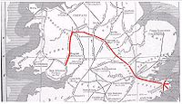
Edgware Road is a major street
which passes through the west of central London
, England, starting at Marble Arch
in the City of Westminster
(south end) and working its way up to Edgware
in the London Borough of Barnet
. It is also the divider of several North London boroughs. The route has its origins as a Roman Road
and today is part of the modern A5 road, undergoing several name changes along its length, including Maida Vale, Kilburn High Road, Shoot Up Hill and Cricklewood Broadway but the road is, as a whole, known as the Edgware Road, as it is the road to Edgware
.
The southern part of the road near Marble Arch
, noted for its distinct Middle Eastern cuisine
and many late-night bars and shisha
cafes, is known to Londoners by nicknames such as Little Cairo, Little Beirut and, especially near Camden
, Little Cyprus
.
, it runs north-west from Marble Arch
to Edgware
on the outskirts of London. It crosses the Harrow Road
and Marylebone Road
(passing beneath the Marylebone flyover). The road passes through the suburbs of Maida Vale, Kilburn and Cricklewood
. It is then joined by the North Circular Road
before West Hendon
at Staples Corner
. After this, the road continues even further north, through The Hyde, Colindale
, Burnt Oak
, and finally, to Edgware
.
The southernmost part of the Edgware Road forms part of the London Inner Ring Road
and as such is part of the boundary of the London congestion charge
zone. However, when the zone was extended in February 2007, the road became part of the "free through routes" which allows vehicles to cross the zone during its hours of operation without paying the charge.
As it passes through the suburbs, the road name changes several times, becoming Maida Vale, Kilburn High Road and Shoot-Up Hill (in Kilburn), and Cricklewood Broadway (in Cricklewood), before becoming Edgware Road once again with intermittent stretches as West Hendon Broadway, and The Hyde
. Along the entire route, it retains its identity as the A5 road under the Great Britain road numbering scheme
. The A5 continues beyond the end of the Edgware Road, following the old Roman route and finally terminating in Holyhead
, Wales
.
. The district's northern boundary is the Marylebone flyover
.
The postal codes
of the area are W1, W2 and NW1
.
The portion of the road stretching between Marble Arch and the Marylebone Flyover also separates the areas of Marylebone
and Bayswater
.
 Before the Romans
, today's Edgware Road began as an ancient trackway
within the Great Middlesex Forest
. The Romans later incorporated the track
into Watling Street
.
Centuries later, the road was improved by the Edgware-Kilburn turnpike trust
in 1711, and a number of the local inns functioned as a stop for coaches, some of which still exist.
During the 18th century, it was a destination for Huguenot migrants. By 1811, Thomas Telford
produced a re-design for what was then known as a section of the London to Holyhead road, a redesign considered one of the most important feats of pre-Victorian engineering.; Telford's redesign emerged only a year after the area saw the establishment of Great Britain's first Indian restaurant.
The area began to attract Arab migrants
in the late 19th century during a period of increased trade with the Ottoman Empire
. The trend continued with the arrival of Egyptians in the 1950s, and greatly expanded beginning in the 1970s and continuing to the present when events including the Lebanese Civil War
, the overthrow of the Shah of Iran
, and unrest in Algeria
brought more Arabs to the area. They established the present-day mix of bars and shisha
cafes, which make the area known to London
ers by nicknames such as "Little Cairo" and "Little Beirut." These shisha cafés have been hard hit by the enforcement of the England-wide smoking ban
in 2007.
One of the two Edgware Road tube station
s was one of the sites of the 7 July bombings
. A bomb was detonated on a train leaving the tube station serving the Circle, District
and Hammersmith & City
lines) and heading for Paddington tube station. Six people were killed in the blast: Colin Morley, 52, Jennifer Vanda Ann Nicholson, 22, Johnathan Downey, 34, Laura Webb, 29, Michael Brewster, 52, and David Foulkes, 22. The perpetrator was the ringleader of the 7 July bombings, Mohammed Siddique Khan. On the first anniversary of the bombings, a memorial plaque to the victims was unveiled at the station.
 The southernmost part of the road, south of the junction with Marylebone Road
, is noted for its distinct Middle East
ern flavour. Many Lebanese restaurant
s, shisha cafes and Arabic-themed nightclubs line the street. The Odeon
cinema, once the location of the biggest screen in London, often shows films in Arabic.
Edgware Road is unique as a district, rich in ethnic culture, yet also in a very central area of London. The area is known for its distinctive and diverse communities from across the Middle East and Africa
, with British Iranian comedian Omid Djalili
describing Edgware Road as "after Damascus
, Medina
and Mecca
, is probably the most Islamic place on the planet".
In addition to branches of the typical Starbucks
, Pret a Manger
, Subway
and Costa Coffee
chains, Edgware Road is home to several Maroush restaurants, a whisky
bar named Salt and a large variety of kebab
and shawarma
restaurants that remain open through the night. Edgware Road is noted for containing within it the famous Church Street Market.
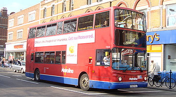 Edgware Road is a major thoroughfare for a number of London bus routes, and is intersected by several London Underground
lines along its length.
A number of schemes have been put forward in the past to construct an Underground railway line underneath Edgware Road, including a plan to extend the Bakerloo line
north to Cricklewood and an unusual proposal to build an underground monorail system, but these schemes did not succeed. Today, London Buses
provide the only public transport along the length of the road.
Day bus routes operating over a significant length of Edgware Road are:
Street
A street is a paved public thoroughfare in a built environment. It is a public parcel of land adjoining buildings in an urban context, on which people may freely assemble, interact, and move about. A street can be as simple as a level patch of dirt, but is more often paved with a hard, durable...
which passes through the west of central London
Central London
Central London is the innermost part of London, England. There is no official or commonly accepted definition of its area, but its characteristics are understood to include a high density built environment, high land values, an elevated daytime population and a concentration of regionally,...
, England, starting at Marble Arch
Marble Arch
Marble Arch is a white Carrara marble monument that now stands on a large traffic island at the junction of Oxford Street, Park Lane, and Edgware Road, almost directly opposite Speakers' Corner in Hyde Park in London, England...
in the City of Westminster
City of Westminster
The City of Westminster is a London borough occupying much of the central area of London, England, including most of the West End. It is located to the west of and adjoining the ancient City of London, directly to the east of the Royal Borough of Kensington and Chelsea, and its southern boundary...
(south end) and working its way up to Edgware
Edgware
Edgware is an area in London, situated north-northwest of Charing Cross. It forms part of both the London Borough of Barnet and the London Borough of Harrow. The area is identified in the London Plan as one of 35 major centres in Greater London....
in the London Borough of Barnet
London Borough of Barnet
The London Borough of Barnet is a London borough in North London and forms part of Outer London. It has a population of 331,500 and covers . It borders Hertfordshire to the north and five other London boroughs: Harrow and Brent to the west, Camden and Haringey to the south-east and Enfield to the...
. It is also the divider of several North London boroughs. The route has its origins as a Roman Road
Roman roads in Britain
Roman roads, together with Roman aqueducts and the vast standing Roman army , constituted the three most impressive features of the Roman Empire. In Britain, as in other provinces, the Romans constructed a comprehensive network of paved trunk roads Roman roads, together with Roman aqueducts and the...
and today is part of the modern A5 road, undergoing several name changes along its length, including Maida Vale, Kilburn High Road, Shoot Up Hill and Cricklewood Broadway but the road is, as a whole, known as the Edgware Road, as it is the road to Edgware
Edgware
Edgware is an area in London, situated north-northwest of Charing Cross. It forms part of both the London Borough of Barnet and the London Borough of Harrow. The area is identified in the London Plan as one of 35 major centres in Greater London....
.
The southern part of the road near Marble Arch
Marble Arch
Marble Arch is a white Carrara marble monument that now stands on a large traffic island at the junction of Oxford Street, Park Lane, and Edgware Road, almost directly opposite Speakers' Corner in Hyde Park in London, England...
, noted for its distinct Middle Eastern cuisine
Middle Eastern cuisine
Middle-Eastern cuisine, West Asian cuisine, or in some place in the United States, Persian-Mediterranean cuisine is the cuisine of the various countries and peoples of the Middle East . The cuisine of the region is diverse while having a degree of homogeneity...
and many late-night bars and shisha
Hookah
A hookah A hookah(Gujarati હૂકાહ) A hookah(Gujarati હૂકાહ) (Hindustani: हुक़्क़ा (Devanagari, (Nastaleeq) huqqah) also known as a waterpipe or narghile, is a single or multi-stemmed (often glass-based) instrument for smoking in which the smoke is cooled by water. The tobacco smoked is referred to...
cafes, is known to Londoners by nicknames such as Little Cairo, Little Beirut and, especially near Camden
London Borough of Camden
In 1801, the civil parishes that form the modern borough were already developed and had a total population of 96,795. This continued to rise swiftly throughout the 19th century, as the district became built up; reaching 270,197 in the middle of the century...
, Little Cyprus
Cyprus
Cyprus , officially the Republic of Cyprus , is a Eurasian island country, member of the European Union, in the Eastern Mediterranean, east of Greece, south of Turkey, west of Syria and north of Egypt. It is the third largest island in the Mediterranean Sea.The earliest known human activity on the...
.
The road
As a roadRoad
A road is a thoroughfare, route, or way on land between two places, which typically has been paved or otherwise improved to allow travel by some conveyance, including a horse, cart, or motor vehicle. Roads consist of one, or sometimes two, roadways each with one or more lanes and also any...
, it runs north-west from Marble Arch
Marble Arch
Marble Arch is a white Carrara marble monument that now stands on a large traffic island at the junction of Oxford Street, Park Lane, and Edgware Road, almost directly opposite Speakers' Corner in Hyde Park in London, England...
to Edgware
Edgware
Edgware is an area in London, situated north-northwest of Charing Cross. It forms part of both the London Borough of Barnet and the London Borough of Harrow. The area is identified in the London Plan as one of 35 major centres in Greater London....
on the outskirts of London. It crosses the Harrow Road
Harrow Road
The Harrow Road is an ancient route in Greater London which runs from Paddington in a northwesterly direction to Harrow. With minor deviations in the 19th and 20th centuries, the route remains otherwise unaltered...
and Marylebone Road
Marylebone Road
Marylebone Road is an important thoroughfare in central London, within the City of Westminster. It runs east-west from the Euston Road at Regent's Park to the A40 Westway at Paddington...
(passing beneath the Marylebone flyover). The road passes through the suburbs of Maida Vale, Kilburn and Cricklewood
Cricklewood
Cricklewood is a district of North London, England whose northeastern part is in the London Borough of Barnet, western part is the London Borough of Brent and southeastern part is in London Borough of Camden.-History:...
. It is then joined by the North Circular Road
A406 road
The A406 or the North Circular Road is a road which crosses North London, UK, linking West and East London. It, together with the South Circular Road, forms a ring road through the inner part of Outer London...
before West Hendon
West Hendon
West Hendon is a place in the London Borough of Barnet.-History:West Hendon was a settlement within that part of the ancient parish of Hendon known as the Hyde, and is now a part of the London Borough of Barnet. It was formally known, from 1878–1890, as New Hendon, a small railway development on...
at Staples Corner
Staples Corner
Staples Corner is a major road junction in London, United Kingdom.It has two linked roundabouts and flyovers, which connect the A406 North Circular Road with the A5 Edgware Road and the start of the M1 motorway...
. After this, the road continues even further north, through The Hyde, Colindale
Colindale
-Transport:*Colindale tube station, on the Northern Line Edgware branch, is situated on the north side of the east-west Colindale Lane.-Development:...
, Burnt Oak
Burnt Oak
Burnt Oak is a suburb predominantly in the London Borough of Barnet south of Edgware, although parts of it fall within Brent and Harrow.The name Burnt Oak was first used in 1754 and from then until the 1850s referred to no more than a field on the eastern side of the Edgware Road...
, and finally, to Edgware
Edgware
Edgware is an area in London, situated north-northwest of Charing Cross. It forms part of both the London Borough of Barnet and the London Borough of Harrow. The area is identified in the London Plan as one of 35 major centres in Greater London....
.
The southernmost part of the Edgware Road forms part of the London Inner Ring Road
London Inner Ring Road
The London Inner Ring Road is the name commonly given to a route formed from a number of major roads that encircle the centremost part of London...
and as such is part of the boundary of the London congestion charge
London congestion charge
The London congestion charge is a fee charged for some categories of motor vehicle to travel at certain times within the Congestion Charge Zone , a traffic area in London. The charge aims to reduce congestion, and raise investment funds for London's transport system...
zone. However, when the zone was extended in February 2007, the road became part of the "free through routes" which allows vehicles to cross the zone during its hours of operation without paying the charge.
As it passes through the suburbs, the road name changes several times, becoming Maida Vale, Kilburn High Road and Shoot-Up Hill (in Kilburn), and Cricklewood Broadway (in Cricklewood), before becoming Edgware Road once again with intermittent stretches as West Hendon Broadway, and The Hyde
The Hyde
The Hyde is a locality in the London Borough of Barnet in London, United Kingdom. The area is considered to form part of Hendon.-History:The name is first recorded in 1281 as la Hyde meaning the hide of land; the amount of land considered enough to support a family, around .-Geography:It is located...
. Along the entire route, it retains its identity as the A5 road under the Great Britain road numbering scheme
Great Britain road numbering scheme
The Great Britain road numbering scheme is a numbering scheme used to classify and identify all roads in Great Britain. Each road is given a single letter, which represents the road's category, and a subsequent number, with a length of between 1 and 4 digits. Originally introduced to arrange...
. The A5 continues beyond the end of the Edgware Road, following the old Roman route and finally terminating in Holyhead
Holyhead
Holyhead is the largest town in the county of Anglesey in the North Wales. It is also a major port adjacent to the Irish Sea serving Ireland....
, Wales
Wales
Wales is a country that is part of the United Kingdom and the island of Great Britain, bordered by England to its east and the Atlantic Ocean and Irish Sea to its west. It has a population of three million, and a total area of 20,779 km²...
.
The area
The name "Edgware Road" is also used to refer to an informal district of London, meaning the area around Marble Arch between Cumberland Gate, just south of Marble Arch, and the north-east corner of Hyde ParkHyde Park, London
Hyde Park is one of the largest parks in central London, United Kingdom, and one of the Royal Parks of London, famous for its Speakers' Corner.The park is divided in two by the Serpentine...
. The district's northern boundary is the Marylebone flyover
Marylebone Road
Marylebone Road is an important thoroughfare in central London, within the City of Westminster. It runs east-west from the Euston Road at Regent's Park to the A40 Westway at Paddington...
.
The postal codes
London postal district
The London postal district is the area in England, currently of , to which mail addressed to the LONDON post town is delivered. The area was initially devised in 1856 and throughout its history has been subject to periodic reorganisation, contraction and division into increasingly smaller postal...
of the area are W1, W2 and NW1
NW postcode area
The NW postcode area, also known as the London NW postcode area, is a group of postcode districts covering part of northwest London, England...
.
The portion of the road stretching between Marble Arch and the Marylebone Flyover also separates the areas of Marylebone
Marylebone
Marylebone is an affluent inner-city area of central London, located within the City of Westminster. It is sometimes written as St. Marylebone or Mary-le-bone....
and Bayswater
Bayswater
Bayswater is an area of west London in the City of Westminster and the Royal Borough of Kensington and Chelsea to the west . It is a built-up district located 3 miles west-north-west of Charing Cross, bordering the north of Hyde Park over Kensington Gardens and having a population density of...
.
History
Prehistoric Britain
For the purposes of this article, Prehistoric Britain is that period of time between the first arrival of humans on the land mass now known as Great Britain and the start of recorded British history...
, today's Edgware Road began as an ancient trackway
Ancient trackway
Ancient trackway can refer to any track or trail whose origin is lost in antiquity. Such paths existed from the earliest prehistoric times and in every inhabited part of the globe...
within the Great Middlesex Forest
Forest of Middlesex
The Forest of Middlesex was an ancient woodland covering much of the county of Middlesex, England that was north of the City of London and now forms the northern part of Greater London. A path was cut through the forest for the creation of Watling Street. At its ancient extent the forest stretched...
. The Romans later incorporated the track
Roman roads in Britain
Roman roads, together with Roman aqueducts and the vast standing Roman army , constituted the three most impressive features of the Roman Empire. In Britain, as in other provinces, the Romans constructed a comprehensive network of paved trunk roads Roman roads, together with Roman aqueducts and the...
into Watling Street
Watling Street
Watling Street is the name given to an ancient trackway in England and Wales that was first used by the Britons mainly between the modern cities of Canterbury and St Albans. The Romans later paved the route, part of which is identified on the Antonine Itinerary as Iter III: "Item a Londinio ad...
.
Centuries later, the road was improved by the Edgware-Kilburn turnpike trust
Turnpike trust
Turnpike trusts in the United Kingdom were bodies set up by individual Acts of Parliament, with powers to collect road tolls for maintaining the principal highways in Britain from the 17th but especially during the 18th and 19th centuries...
in 1711, and a number of the local inns functioned as a stop for coaches, some of which still exist.
During the 18th century, it was a destination for Huguenot migrants. By 1811, Thomas Telford
Thomas Telford
Thomas Telford FRS, FRSE was a Scottish civil engineer, architect and stonemason, and a noted road, bridge and canal builder.-Early career:...
produced a re-design for what was then known as a section of the London to Holyhead road, a redesign considered one of the most important feats of pre-Victorian engineering.; Telford's redesign emerged only a year after the area saw the establishment of Great Britain's first Indian restaurant.
The area began to attract Arab migrants
Arab diaspora
Arab diaspora refers to Arab immigrants, and their descendants who, voluntarily or as refugees, emigrated from their native lands and now reside in non-Arab countries, primarily in Latin America, and Europe, as well as North America and South Asia, parts of Southeast Asia, the Caribbean, and West...
in the late 19th century during a period of increased trade with the Ottoman Empire
Ottoman Empire
The Ottoman EmpireIt was usually referred to as the "Ottoman Empire", the "Turkish Empire", the "Ottoman Caliphate" or more commonly "Turkey" by its contemporaries...
. The trend continued with the arrival of Egyptians in the 1950s, and greatly expanded beginning in the 1970s and continuing to the present when events including the Lebanese Civil War
Lebanese Civil War
The Lebanese Civil War was a multifaceted civil war in Lebanon. The war lasted from 1975 to 1990 and resulted in an estimated 150,000 to 230,000 civilian fatalities. Another one million people were wounded, and today approximately 350,000 people remain displaced. There was also a mass exodus of...
, the overthrow of the Shah of Iran
Iranian Revolution
The Iranian Revolution refers to events involving the overthrow of Iran's monarchy under Shah Mohammad Reza Pahlavi and its replacement with an Islamic republic under Ayatollah Ruhollah Khomeini, the leader of the...
, and unrest in Algeria
Algerian Civil War
The Algerian Civil War was an armed conflict between the Algerian government and various Islamist rebel groups which began in 1991. It is estimated to have cost between 150,000 and 200,000 lives, in a population of about 25,010,000 in 1990 and 31,193,917 in 2000.More than 70 journalists were...
brought more Arabs to the area. They established the present-day mix of bars and shisha
Hookah
A hookah A hookah(Gujarati હૂકાહ) A hookah(Gujarati હૂકાહ) (Hindustani: हुक़्क़ा (Devanagari, (Nastaleeq) huqqah) also known as a waterpipe or narghile, is a single or multi-stemmed (often glass-based) instrument for smoking in which the smoke is cooled by water. The tobacco smoked is referred to...
cafes, which make the area known to London
London
London is the capital city of :England and the :United Kingdom, the largest metropolitan area in the United Kingdom, and the largest urban zone in the European Union by most measures. Located on the River Thames, London has been a major settlement for two millennia, its history going back to its...
ers by nicknames such as "Little Cairo" and "Little Beirut." These shisha cafés have been hard hit by the enforcement of the England-wide smoking ban
Smoking ban
Smoking bans are public policies, including criminal laws and occupational safety and health regulations, which prohibit tobacco smoking in workplaces and/or other public spaces...
in 2007.
One of the two Edgware Road tube station
Edgware Road tube station
Edgware Road station is a London Underground station on the corner of Chapel Street and Cabbell Street Road in Travelcard Zone 1 serving the Circle, District and Hammersmith & City lines. The separate Edgware Road tube station is about 150 metres away on the opposite side of the Marylebone Road...
s was one of the sites of the 7 July bombings
7 July 2005 London bombings
The 7 July 2005 London bombings were a series of co-ordinated suicide attacks in the United Kingdom, targeting civilians using London's public transport system during the morning rush hour....
. A bomb was detonated on a train leaving the tube station serving the Circle, District
District Line
The District line is a line of the London Underground, coloured green on the Tube map. It is a "sub-surface" line, running through the central area in shallow cut-and-cover tunnels. It is the busiest of the sub-surface lines. Out of the 60 stations served, 25 are underground...
and Hammersmith & City
Hammersmith & City Line
The Hammersmith & City line is a subsurface London Underground line. It connects Hammersmith in the west with Barking in the east, running through the northern part of central London. It is coloured salmon pink on the Tube map...
lines) and heading for Paddington tube station. Six people were killed in the blast: Colin Morley, 52, Jennifer Vanda Ann Nicholson, 22, Johnathan Downey, 34, Laura Webb, 29, Michael Brewster, 52, and David Foulkes, 22. The perpetrator was the ringleader of the 7 July bombings, Mohammed Siddique Khan. On the first anniversary of the bombings, a memorial plaque to the victims was unveiled at the station.
Culture
Marylebone Road
Marylebone Road is an important thoroughfare in central London, within the City of Westminster. It runs east-west from the Euston Road at Regent's Park to the A40 Westway at Paddington...
, is noted for its distinct Middle East
Middle East
The Middle East is a region that encompasses Western Asia and Northern Africa. It is often used as a synonym for Near East, in opposition to Far East...
ern flavour. Many Lebanese restaurant
Lebanese cuisine
Lebanese cuisine includes an abundance of starches, fruits, vegetables, fresh fish and seafood; animal fats are consumed sparingly. Poultry is eaten more often than red meat, and when red meat is eaten it is usually lamb on the coast and goat meat in the mountain regions...
s, shisha cafes and Arabic-themed nightclubs line the street. The Odeon
Odeon Cinemas
Odeon Cinemas is a British chain of cinemas, one of the largest in Europe. It is owned by Odeon & UCI Cinemas Group whose ultimate parent is Terra Firma Capital Partners.-History:Odeon Cinemas was created in 1928 by Oscar Deutsch...
cinema, once the location of the biggest screen in London, often shows films in Arabic.
Edgware Road is unique as a district, rich in ethnic culture, yet also in a very central area of London. The area is known for its distinctive and diverse communities from across the Middle East and Africa
Africa
Africa is the world's second largest and second most populous continent, after Asia. At about 30.2 million km² including adjacent islands, it covers 6% of the Earth's total surface area and 20.4% of the total land area...
, with British Iranian comedian Omid Djalili
Omid Djalili
Omid Djalili is a British Iranian stand-up comedian, actor, television producer and writer.-Personal life:Djalili was born in Chelsea, London to Iranian Bahá'í parents and is a Bahá'í himself...
describing Edgware Road as "after Damascus
Damascus
Damascus , commonly known in Syria as Al Sham , and as the City of Jasmine , is the capital and the second largest city of Syria after Aleppo, both are part of the country's 14 governorates. In addition to being one of the oldest continuously inhabited cities in the world, Damascus is a major...
, Medina
Medina
Medina , or ; also transliterated as Madinah, or madinat al-nabi "the city of the prophet") is a city in the Hejaz region of western Saudi Arabia, and serves as the capital of the Al Madinah Province. It is the second holiest city in Islam, and the burial place of the Islamic Prophet Muhammad, and...
and Mecca
Mecca
Mecca is a city in the Hijaz and the capital of Makkah province in Saudi Arabia. The city is located inland from Jeddah in a narrow valley at a height of above sea level...
, is probably the most Islamic place on the planet".
In addition to branches of the typical Starbucks
Starbucks
Starbucks Corporation is an international coffee and coffeehouse chain based in Seattle, Washington. Starbucks is the largest coffeehouse company in the world, with 17,009 stores in 55 countries, including over 11,000 in the United States, over 1,000 in Canada, over 700 in the United Kingdom, and...
, Pret a Manger
Pret A Manger
Pret a Manger is a British sandwich retail chain based in the City of Westminster, London, United Kingdom. The name "Pret a Manger" comes from the French prêt à manger, meaning "ready to eat", a reference to prêt-à-porter .The company was founded in London in 1986 by friends Sinclair Beecham and...
, Subway
Subway (restaurant)
Subway is an American restaurant franchise that primarily sells submarine sandwiches and salads. It is owned and operated by Doctor's Associates, Inc. . Subway is one of the fastest growing franchises in the world with 35,519 restaurants in 98 countries and territories as of October 25th, 2011...
and Costa Coffee
Costa Coffee
Costa Coffee is a British coffeehouse company founded in 1971 by Italian brothers Sergio and Bruno Costa, as a wholesale operation supplying roasted coffee to caterers and specialist Italian coffee shops. Since 1995 it has been a subsidiary of Whitbread, since when the company has grown to over...
chains, Edgware Road is home to several Maroush restaurants, a whisky
Whisky
Whisky or whiskey is a type of distilled alcoholic beverage made from fermented grain mash. Different grains are used for different varieties, including barley, malted barley, rye, malted rye, wheat, and corn...
bar named Salt and a large variety of kebab
Kebab
Kebab is a wide variety of meat dishes originating in Middle East and later on adopted by the Middle East, and Asia Minor, and now found worldwide. In English, kebab with no qualification generally refers more specifically to shish kebab served on the skewer...
and shawarma
Shawarma
Shawarma is a Levantine Arab sandwich-like wrap of shaved lamb, goat, chicken, turkey, beef, or mixed meats. The meat is placed on a spit, and may be grilled for as long as a day. It is eaten with pita bread, tabbouleh, fattoush, taboon bread, tomato and cucumber. Toppings include tahini, hummus,...
restaurants that remain open through the night. Edgware Road is noted for containing within it the famous Church Street Market.
Institutions of note
- A WetherspoonsWetherspoonsJ D Wetherspoon plc is a British pub chain based in Watford. Founded as a single pub in 1979 by Tim Martin, the company now owns 815 outlets. The chain champions cask ale, low prices, long opening hours, and no music. The company also operates the Lloyds No...
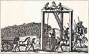
tavern, The Tyburn, is named after the 'TyburnTyburn, LondonTyburn was a village in the county of Middlesex close to the current location of Marble Arch in present-day London. It took its name from the Tyburn or Teo Bourne 'boundary stream', a tributary of the River Thames which is now completely covered over between its source and its outfall into the...
tree', once the principal site of execution in London. Today, three golden triangles indicate the location of the tree, at the southernmost end of Edgware Road. - A MarriottMarriott InternationalMarriott International, Inc. is a worldwide operator and franchisor of a broad portfolio of hotels and related lodging facilities. Founded by J. Willard Marriott, the company is now led by son J.W. Marriott, Jr...
Hotel is situated to the east of the road on George Street, between Marble ArchMarble ArchMarble Arch is a white Carrara marble monument that now stands on a large traffic island at the junction of Oxford Street, Park Lane, and Edgware Road, almost directly opposite Speakers' Corner in Hyde Park in London, England...
and the Marylebone flyover. - The Seymour Leisure Centre lies on Seymour Place.
- The University of LondonUniversity of London-20th century:Shortly after 6 Burlington Gardens was vacated, the University went through a period of rapid expansion. Bedford College, Royal Holloway and the London School of Economics all joined in 1900, Regent's Park College, which had affiliated in 1841 became an official divinity school of the...
has residences on Brown Street, east of Edgware Road, and in Sussex Gardens and Talbot Square, to its west. - The York Building is currently under construction. It will house luxury apartments, office space as well as retail area on its ground level.
- The Comfort Inn Edgware Road is located in a walkable distance from Edgware Road & Marble Arch tube station.
- The Hilton London Metropole Hotel is located in a walkable distance from both Edgware Road underground stations.
- The Grosvenor London Victoria Casino is located at 150-162 Edgware Road and is a popular casino for Londoners.
- The main campus of City of Westminster CollegeCity of Westminster CollegeCity of Westminster College is a further education college located in the borough of Westminster, central London. The College has two centres located in Paddington and Queen's Park...
is located on Paddington GreenPaddington Green conservation areaPaddington Green conservation area is a green space and geographic location in Westminster located off Edgware Road and adjacent to Westway. It is the oldest part of Paddington and became a separate conservation area in 1988, having previously formed part of Maida Vale conservation area...
, off Edgware Road.
Transport
London Underground
The London Underground is a rapid transit system serving a large part of Greater London and some parts of Buckinghamshire, Hertfordshire and Essex in England...
lines along its length.
A number of schemes have been put forward in the past to construct an Underground railway line underneath Edgware Road, including a plan to extend the Bakerloo line
Bakerloo Line
The Bakerloo line is a line of the London Underground, coloured brown on the Tube map. It runs partly on the surface and partly at deep level, from Elephant and Castle in the south-east to Harrow & Wealdstone in the north-west of London. The line serves 25 stations, of which 15 are underground...
north to Cricklewood and an unusual proposal to build an underground monorail system, but these schemes did not succeed. Today, London Buses
London Buses
London Buses is the subsidiary of Transport for London that manages bus services within Greater London, UK. Buses are required to carry similar red colour schemes and conform to the same fare scheme...
provide the only public transport along the length of the road.
London Underground
- Edgware Road (Bakerloo LineEdgware Road tube station (Bakerloo Line)Edgware Road is a London Underground station in the City of Westminster. It is served by the Bakerloo line and is between Paddington and Marylebone stations. It is in Travelcard Zone 1. The station is located on the north-east corner of the junction of Edgware Road, Harrow Road and Marylebone Road...
) (Circle, DistrictDistrict LineThe District line is a line of the London Underground, coloured green on the Tube map. It is a "sub-surface" line, running through the central area in shallow cut-and-cover tunnels. It is the busiest of the sub-surface lines. Out of the 60 stations served, 25 are underground...
and Hammersmith & City LinesHammersmith & City LineThe Hammersmith & City line is a subsurface London Underground line. It connects Hammersmith in the west with Barking in the east, running through the northern part of central London. It is coloured salmon pink on the Tube map...
) (Central LineCentral LineThe Central line is a London Underground line, coloured red on the tube map. It is a deep-level "tube" line, running east-west across London, and, at , has the greatest total length of track of any line on the Underground. Of the 49 stations served, 20 are below ground...
) (Bakerloo Line) (Bakerloo, Circle, District and Hammersmith & City Lines)
Bus routes
Night bus route 16 is the only route to run the full length of the Edgware Road, from Victoria station to Edgware.Day bus routes operating over a significant length of Edgware Road are:
- 6London Buses route 6London Buses route 6 is a Transport for London contracted bus route in London, United Kingdom. The service is currently contracted to Metroline.-History:...
- 16London Buses route 16London Buses route 16 is a Transport for London contracted bus route in London, England, United Kingdom. The service is currently contracted to Metroline.-History:...
- 32
- 36London Buses route 36London Buses route 36 is a Transport for London contracted bus route in London, United Kingdom. The service is currently contracted to Go-Ahead London.-The Beginning:...
- 98
- 189
- 332
- 414
External links
- Go west for a taste of Arabia – while it lasts from thelondonpaperThelondonpaperThe London Paper was a free daily newspaper, published by NI Free Newspapers Ltd, a subsidiary of News International...